More like 'Sambo's Pancake House'
Narrow Results By
Subject
- Accidents - Automobile Accidents 13
- Advertising Medium 2
- Advertising Medium - Signs and Signboards 11
- Aerial Photographs 1
- Agricultural Tools and Equipment - Gardening Equipment 1
- Agriculture 3
- Agriculture - Crops 2
- Agriculture - Farms 13
- Agriculture - Fruit and Berries 1
- Animals - Birds 4
- Animals - Cats 1
- Animals - Cows 1

Duncan & Margaret McGregor Estate 'Glen-Lyon' New Haven Barn
https://search.heritageburnaby.ca/link/landmark852
- Repository
- Burnaby Heritage Planning
- Description
- Designed in a vernacular architectural style, the New Haven Barn is a large gambrel-roofed barn located on the Edwardian era McGregor Estate 'Glen-Lyon,' overlooking the rich farmland of the Fraser River floodplain and near a ravine and forested area adjacent to Marine Drive in South Burnaby.
- Associated Dates
- 1939
- Formal Recognition
- Heritage Designation, Community Heritage Register
- Other Names
- Home of the Friendless, New Haven Borstal Home for Boys and Youthful Offenders, New Haven Correction Centre
- Street View URL
- Google Maps Street View
- Repository
- Burnaby Heritage Planning
- Other Names
- Home of the Friendless, New Haven Borstal Home for Boys and Youthful Offenders, New Haven Correction Centre
- Geographic Access
- Marine Drive
- Associated Dates
- 1939
- Formal Recognition
- Heritage Designation, Community Heritage Register
- Enactment Type
- Bylaw No. 12183
- Enactment Date
- 11/12/2006
- Description
- Designed in a vernacular architectural style, the New Haven Barn is a large gambrel-roofed barn located on the Edwardian era McGregor Estate 'Glen-Lyon,' overlooking the rich farmland of the Fraser River floodplain and near a ravine and forested area adjacent to Marine Drive in South Burnaby.
- Heritage Value
- The site is historically significant for its association with early social welfare and correctional reform. The estate was sold in 1926 to an inter-denominational religious organization called the Home of the Friendless, which used it as their B.C. headquarters. The organization was charged with several cases of abuse and neglect in 1937, after which a Royal Commission was formed that led to new legislation to regulate and license all private welfare institutions. 'Glen-Lyon' was sold to the provincial government, and was dedicated in 1939 by the Lt.-Gov. E.W. Hamber for use as the New Haven Borstal Home for Boys and Youthful Offenders (later renamed the New Haven Correction Centre). The Borstal movement originated in England in the late nineteenth century, as an alternative to sending young offenders and runaways to prisons by providing reformatories that focused on discipline and vocational skill. This site’s role as the first North American institution devoted to the Borstal School philosophy was historic, and influenced corrections programs across Canada. The New Haven Barn is a significant feature from its development in 1939 as the Borstal School, designed by Chief Provincial Architect Henry Whittaker of the Department of Public Works, and is the only remaining structure of its kind in Burnaby.
- Defining Elements
- Key elements that define the heritage character of the New Haven Barn include its: - gambrel-roofed barn with roof vent with finial, sliding hay loft and access doors, small multi-pane windows, and lapped wooden siding
- Historic Neighbourhood
- Fraser Arm (Historic Neighbourhood)
- Planning Study Area
- Big Bend Area
- Architect
- Henry Whittaker
- Function
- Primary Historic--Estate
- Community
- Burnaby
- Cadastral Identifier
- 003-004-661
- Boundaries
- 'Glen-Lyon' is comprised of a single residential lot located at 4250 Marine Drive, Burnaby.
- Area
- 230873.18
- Contributing Resource
- Building
- Ownership
- Private
- Names
- Whittaker, George
- New Haven Borstal Home for Boys and Youthful Offenders
- New Haven Correction Centre
- Borstal School
- Street Address
- 4250 Marine Drive
- Street View URL
- Google Maps Street View
Images


![Moscrop Secondary School, [2000] thumbnail](/media/hpo/_Data/_Archives_Images/_Unrestricted/535/535-2124-3.jpg?width=280)
Moscrop Secondary School
https://search.heritageburnaby.ca/link/archivedescription96500
- Repository
- City of Burnaby Archives
- Date
- [2000]
- Collection/Fonds
- Burnaby NewsLeader photograph collection
- Description Level
- File
- Physical Description
- 3 photographs (tiff) : b&w
- Scope and Content
- File contains photographs of Moscrop Secondary School. Photographs depict portables outside the school, with residential homes visible in the background; the school parking lot; and students gathering on the stairs and in the front lobby of the school.
- Repository
- City of Burnaby Archives
- Date
- [2000]
- Collection/Fonds
- Burnaby NewsLeader photograph collection
- Physical Description
- 3 photographs (tiff) : b&w
- Description Level
- File
- Record No.
- 535-2124
- Access Restriction
- No restrictions
- Reproduction Restriction
- No restrictions
- Accession Number
- 2018-12
- Scope and Content
- File contains photographs of Moscrop Secondary School. Photographs depict portables outside the school, with residential homes visible in the background; the school parking lot; and students gathering on the stairs and in the front lobby of the school.
- Names
- Moscrop Secondary School
- Media Type
- Photograph
- Notes
- Title based on caption
- Collected by editorial for use in a March 2000 issue of the Burnaby NewsLeader
- Geographic Access
- Moscrop Street
- Street Address
- 4433 Moscrop Street
- Planning Study Area
- Cascade-Schou Area
Images
![Moscrop Secondary School, [2000] thumbnail](/media/hpo/_Data/_Archives_Images/_Unrestricted/535/535-2124-3.jpg)
![City of Burnaby parking pay station, [2004] thumbnail](/media/hpo/_Data/_Archives_Images/_Unrestricted/535/535-2057.jpg?width=280)
City of Burnaby parking pay station
https://search.heritageburnaby.ca/link/archivedescription96387
- Repository
- City of Burnaby Archives
- Date
- [2004]
- Collection/Fonds
- Burnaby NewsLeader photograph collection
- Description Level
- Item
- Physical Description
- 1 photograph (tiff) : col.
- Scope and Content
- Photograph of Kevin Lusignan, traffic technician for parking in the City of Burnaby, and Dennis Wong, from Precise ParkLink. They are standing on Ledger Avenue next to one of the new parking pay stations that would replace parking meters.
- Repository
- City of Burnaby Archives
- Date
- [2004]
- Collection/Fonds
- Burnaby NewsLeader photograph collection
- Physical Description
- 1 photograph (tiff) : col.
- Description Level
- Item
- Record No.
- 535-2057
- Access Restriction
- No restrictions
- Reproduction Restriction
- No restrictions
- Accession Number
- 2018-12
- Scope and Content
- Photograph of Kevin Lusignan, traffic technician for parking in the City of Burnaby, and Dennis Wong, from Precise ParkLink. They are standing on Ledger Avenue next to one of the new parking pay stations that would replace parking meters.
- Subjects
- Occupations - Civic Workers
- Geographic Features - Automobile Parking Lots
- Public Services - Municipal Services
- Media Type
- Photograph
- Photographer
- Bartel, Mario
- Notes
- Title based on caption
- Collected by editorial for use in a March 2004 issue of the Burnaby NewsLeader
- Caption from metadata: "Kevin Lusignan, the traffic technician for parking in the City of Burnaby, checks out one of the new pay stations that will be installed along Ledger Ave., instead of parking meters. With him is Dennis Wong, of Precise ParkLink, the company supplying the pay stations."
- Geographic Access
- Ledger Avenue
- Historic Neighbourhood
- Burnaby Lake (Historic Neighbourhood)
- Planning Study Area
- Ardingley-Sprott Area
Images
![City of Burnaby parking pay station, [2004] thumbnail](/media/hpo/_Data/_Archives_Images/_Unrestricted/535/535-2057.jpg)
![Filmmakers Daljit DJ Parmar and Kabir Shaukat, [2001] thumbnail](/media/hpo/_Data/_Archives_Images/_Unrestricted/535/535-1842.jpg?width=280)
Filmmakers Daljit DJ Parmar and Kabir Shaukat
https://search.heritageburnaby.ca/link/archivedescription96145
- Repository
- City of Burnaby Archives
- Date
- [2001]
- Collection/Fonds
- Burnaby NewsLeader photograph collection
- Description Level
- Item
- Physical Description
- 1 photograph (tiff) : col.
- Scope and Content
- Photograph of filmmakers Daljit DJ Parmar and Kabir Shaukat seated on the hood of a yellow car in a parking lot.
- Repository
- City of Burnaby Archives
- Date
- [2001]
- Collection/Fonds
- Burnaby NewsLeader photograph collection
- Physical Description
- 1 photograph (tiff) : col.
- Description Level
- Item
- Record No.
- 535-1842
- Access Restriction
- No restrictions
- Reproduction Restriction
- No restrictions
- Accession Number
- 2018-12
- Scope and Content
- Photograph of filmmakers Daljit DJ Parmar and Kabir Shaukat seated on the hood of a yellow car in a parking lot.
- Media Type
- Photograph
- Notes
- Title based on caption
- Collected by editorial for use in a January 2005 issue of the Burnaby NewsLeader
- Caption from metadata for 535-1842: "Film makers Daljit DJ Parmar (right) and Kabir Shaukat produced an anti drinking and driving video."
Images
![Filmmakers Daljit DJ Parmar and Kabir Shaukat, [2001] thumbnail](/media/hpo/_Data/_Archives_Images/_Unrestricted/535/535-1842.jpg)
![3700 block of Hastings Street, [2000] thumbnail](/media/hpo/_Data/_Archives_Images/_Unrestricted/535/535-3066.jpg?width=280)
3700 block of Hastings Street
https://search.heritageburnaby.ca/link/archivedescription97940
- Repository
- City of Burnaby Archives
- Date
- [2000]
- Collection/Fonds
- Burnaby NewsLeader photograph collection
- Description Level
- Item
- Physical Description
- 1 photograph (tiff) : b&w
- Scope and Content
- Photograph of the 3700 block of Hastings Street in North Burnaby, looking southeast. Kato Japanese Chinese Restaurant is one of the visible businesses and some snow is on the ground.
- Repository
- City of Burnaby Archives
- Date
- [2000]
- Collection/Fonds
- Burnaby NewsLeader photograph collection
- Physical Description
- 1 photograph (tiff) : b&w
- Description Level
- Item
- Record No.
- 535-3066
- Access Restriction
- No restrictions
- Reproduction Restriction
- No restrictions
- Accession Number
- 2018-12
- Scope and Content
- Photograph of the 3700 block of Hastings Street in North Burnaby, looking southeast. Kato Japanese Chinese Restaurant is one of the visible businesses and some snow is on the ground.
- Subjects
- Geographic Features - Roads
- Buildings - Commercial
- Buildings - Commercial - Restaurants
- Buildings - Residential
- Media Type
- Photograph
- Notes
- Title based on contents of photograph
- Collected by editorial for use in a January 2000 issue of the Burnaby NewsLeader
- Geographic Access
- Hastings Street
- Street Address
- 3700 Hastings Street
- Historic Neighbourhood
- Vancouver Heights (Historic Neighbourhood)
- Planning Study Area
- Burnaby Heights Area
Images
![3700 block of Hastings Street, [2000] thumbnail](/media/hpo/_Data/_Archives_Images/_Unrestricted/535/535-3066.jpg)

Brown's guide to British Columbia
https://search.heritageburnaby.ca/link/museumlibrary4891
- Repository
- Burnaby Village Museum
- Collection
- Special Collection
- Material Type
- Textual Record
- Accession Code
- HV975.15.13
- Call Number
- 317.1 BRO
- Author
- Brown, Conway
- Place of Publication
- Ottawa
- Publisher
- Conway Brown
- Publication Date
- 1934
- Physical Description
- 112 p. : ill. (maps) : 17 cm.
- Library Subject (LOC)
- Guidebooks
- Canada, Western
- British Columbia
- British Columbia--Maps
- British Columbia--Politics and government
- Subjects
- Documentary Artifacts
- Documentary Artifacts - Booklets
- Elections
- Geographic Features - Districts - Electoral Districts
- Notes
- Includes index.
- "This issue contains federal electoral map of B.C. showing boundaries of new ridings clearly, so that every riding is easily distinguished." -- Cover
Images

![Delivery driver Dylan Dupuis, [2000] thumbnail](/media/hpo/_Data/_Archives_Images/_Unrestricted/535/535-2681.jpg?width=280)
Delivery driver Dylan Dupuis
https://search.heritageburnaby.ca/link/archivedescription97284
- Repository
- City of Burnaby Archives
- Date
- [2000]
- Collection/Fonds
- Burnaby NewsLeader photograph collection
- Description Level
- Item
- Physical Description
- 1 photograph (tiff) : col.
- Scope and Content
- Photograph of Dylan Dupuis, a Panagopoulos pizza delivery driver, posing in the door of his car in uniform with a pizza delivery bag and a sign for the Arco service station behind him, near Kingsway and Gilley.
- Repository
- City of Burnaby Archives
- Date
- [2000]
- Collection/Fonds
- Burnaby NewsLeader photograph collection
- Physical Description
- 1 photograph (tiff) : col.
- Description Level
- Item
- Record No.
- 535-2681
- Access Restriction
- No restrictions
- Reproduction Restriction
- Reproduce for fair dealing purposes only
- Accession Number
- 2018-12
- Scope and Content
- Photograph of Dylan Dupuis, a Panagopoulos pizza delivery driver, posing in the door of his car in uniform with a pizza delivery bag and a sign for the Arco service station behind him, near Kingsway and Gilley.
- Media Type
- Photograph
- Photographer
- Bartel, Mario
- Notes
- Title based on caption
- Collected by editorial for use in a September 2000 issue of the Burnaby NewsLeader
- Caption from metadata: "The high price of gas is making it difficult for delivery drivers, like Dylan Dupuis, to make any money, and businesses are facing raising their prices to cover their increased costs."
- Geographic Access
- Kingsway
- Gilley Avenue
- Historic Neighbourhood
- Edmonds (Historic Neighbourhood)
- Planning Study Area
- Kingsway-Beresford Area
Images
![Delivery driver Dylan Dupuis, [2000] thumbnail](/media/hpo/_Data/_Archives_Images/_Unrestricted/535/535-2681.jpg)
![Rick Boyd, [2000] thumbnail](/media/hpo/_Data/_Archives_Images/_Unrestricted/535/535-2130.jpg?width=280)
Rick Boyd
https://search.heritageburnaby.ca/link/archivedescription96506
- Repository
- City of Burnaby Archives
- Date
- [2000]
- Collection/Fonds
- Burnaby NewsLeader photograph collection
- Description Level
- Item
- Physical Description
- 1 photograph (tiff) : col.
- Scope and Content
- Photograph of Rick Boyd, the President of the BC and Yukon Hotel Association, tearing up a WorkSafe card that reads: "Effective January 1, 2000 this establishment will be smoke-free in accordance with the WCB second-hand smoke standards to protect workers." Boyd is standing in a restaurant with a b…
- Repository
- City of Burnaby Archives
- Date
- [2000]
- Collection/Fonds
- Burnaby NewsLeader photograph collection
- Physical Description
- 1 photograph (tiff) : col.
- Description Level
- Item
- Record No.
- 535-2130
- Access Restriction
- No restrictions
- Reproduction Restriction
- No restrictions
- Accession Number
- 2018-12
- Scope and Content
- Photograph of Rick Boyd, the President of the BC and Yukon Hotel Association, tearing up a WorkSafe card that reads: "Effective January 1, 2000 this establishment will be smoke-free in accordance with the WCB second-hand smoke standards to protect workers." Boyd is standing in a restaurant with a bar visible behind him.
- Subjects
- Buildings - Commercial - Hotels and Motels
- Buildings - Commercial - Restaurants
- Organizations
- Media Type
- Photograph
- Photographer
- Bartel, Mario
- Notes
- Title based on caption
- Collected by editorial for use in a March 2000 issue of the Burnaby NewsLeader
- Caption from metadata: "Rick Boyd, the President of the BC and Yukon Hotel Association, is pleased the BC Supreme Court has torn up the Worker's Compensation Board's smoking ban in pubs and restaurants."
Images
![Rick Boyd, [2000] thumbnail](/media/hpo/_Data/_Archives_Images/_Unrestricted/535/535-2130.jpg)
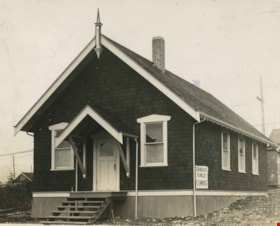
Tabernacle Church
https://search.heritageburnaby.ca/link/archivedescription38676
- Repository
- City of Burnaby Archives
- Date
- 1930
- Collection/Fonds
- Burnaby Historical Society fonds
- Description Level
- Item
- Physical Description
- 1 photograph : b&w postcard ; 9 x 10.8 cm
- Scope and Content
- Photographic postcard of the Union Tabernacle Church at 3891 Georgia Street.
- Repository
- City of Burnaby Archives
- Date
- 1930
- Collection/Fonds
- Burnaby Historical Society fonds
- Subseries
- North Burnaby Board of Trade subseries
- Physical Description
- 1 photograph : b&w postcard ; 9 x 10.8 cm
- Description Level
- Item
- Record No.
- 476-019
- Access Restriction
- No restrictions
- Reproduction Restriction
- No known restrictions
- Accession Number
- BHS2005-8
- Scope and Content
- Photographic postcard of the Union Tabernacle Church at 3891 Georgia Street.
- Names
- Grace Tabernacle Church
- Media Type
- Photograph
- Notes
- Title based on contents of photograph.
- Geographic Access
- Georgia Street
- Historic Neighbourhood
- Vancouver Heights (Historic Neighbourhood)
- Planning Study Area
- Willingdon Heights Area
Images
![Fire fighters at a car accident, [2006] thumbnail](/media/hpo/_Data/_Archives_Images/_Unrestricted/535/535-1894-2.jpg?width=280)
Fire fighters at a car accident
https://search.heritageburnaby.ca/link/archivedescription96197
- Repository
- City of Burnaby Archives
- Date
- [2006]
- Collection/Fonds
- Burnaby NewsLeader photograph collection
- Description Level
- File
- Physical Description
- 2 photographs (tiff) : col.
- Scope and Content
- File contains photographs of Burnaby fire fighters assisting in the aftermath of an automobile accident that occurred when a driver lost control and hit two cars in the parking lot of the Metrotown Mazda at Kingsway and Imperial.
- Repository
- City of Burnaby Archives
- Date
- [2006]
- Collection/Fonds
- Burnaby NewsLeader photograph collection
- Physical Description
- 2 photographs (tiff) : col.
- Description Level
- File
- Record No.
- 535-1894
- Access Restriction
- No restrictions
- Reproduction Restriction
- No restrictions
- Accession Number
- 2018-12
- Scope and Content
- File contains photographs of Burnaby fire fighters assisting in the aftermath of an automobile accident that occurred when a driver lost control and hit two cars in the parking lot of the Metrotown Mazda at Kingsway and Imperial.
- Subjects
- Occupations - Fire Fighters
- Accidents - Automobile Accidents
- Buildings - Commercial - Automobile Dealerships
- Names
- Burnaby Fire Department
- Media Type
- Photograph
- Photographer
- Bartel, Mario
- Notes
- Title based on caption
- Collected by editorial for use in a January 2006 issue of the Burnaby NewsLeader
- Caption from metadata for 535-1894-1: "Burnaby firefighters prepare the driver of a Lexus that lost control at Kingsway and Imperial and smashed into two cars on the lot at Metrotown Mazda for transport to hospital on Thursday."
- Caption from metadata for 535-1894-2: "A Burnaby firefighter works to secure a Lexus that lost control at Kingsway and Imperial on Thursday, smashing into two brand new Mazdas on the lot at Metrotown Mazda. The driver of the Lexus was transported to hospital with undertermined minor injuries."
- Geographic Access
- Kingsway
- Imperial Street
- Historic Neighbourhood
- Central Park (Historic Neighbourhood)
- Planning Study Area
- Maywood Area
Images
![Fire fighters at a car accident, [2006] thumbnail](/media/hpo/_Data/_Archives_Images/_Unrestricted/535/535-1894-2.jpg)
![Walsh Motors, [1936] (date of original), copied 1992 thumbnail](/media/hpo/_Data/_Archives_Images/_Unrestricted/315/315-033.jpg?width=280)
Walsh Motors
https://search.heritageburnaby.ca/link/archivedescription36678
- Repository
- City of Burnaby Archives
- Date
- [1936] (date of original), copied 1992
- Collection/Fonds
- Burnaby Historical Society fonds
- Description Level
- Item
- Physical Description
- 1 photograph : b&w ; 6.8 x 12.0 cm print
- Scope and Content
- Photograph of Walsh Motors, opened by Frank Walsh in the early 1930s at 4161 Hastings Street. In 1948, the site of Walsh Motors became Eagle Motors.
- Repository
- City of Burnaby Archives
- Date
- [1936] (date of original), copied 1992
- Collection/Fonds
- Burnaby Historical Society fonds
- Subseries
- Burnaby Centennial Anthology subseries
- Physical Description
- 1 photograph : b&w ; 6.8 x 12.0 cm print
- Description Level
- Item
- Record No.
- 315-033
- Access Restriction
- No restrictions
- Reproduction Restriction
- No known restrictions
- Accession Number
- BHS1994-04
- Scope and Content
- Photograph of Walsh Motors, opened by Frank Walsh in the early 1930s at 4161 Hastings Street. In 1948, the site of Walsh Motors became Eagle Motors.
- Names
- Walsh Motors
- Media Type
- Photograph
- Notes
- Title based on contents of photograph
- Geographic Access
- Hastings Street
- Street Address
- 4161 Hastings Street
- Historic Neighbourhood
- Vancouver Heights (Historic Neighbourhood)
- Planning Study Area
- Burnaby Heights Area
Images
![Walsh Motors, [1936] (date of original), copied 1992 thumbnail](/media/hpo/_Data/_Archives_Images/_Unrestricted/315/315-033.jpg)
![John Teti at the Shark Club, [2003] thumbnail](/media/hpo/_Data/_Archives_Images/_Unrestricted/535/535-2023.jpg?width=280)
John Teti at the Shark Club
https://search.heritageburnaby.ca/link/archivedescription96342
- Repository
- City of Burnaby Archives
- Date
- [2003]
- Collection/Fonds
- Burnaby NewsLeader photograph collection
- Description Level
- Item
- Physical Description
- 1 photograph (tiff) : col.
- Scope and Content
- Photograph of John Teti posing on the roof of the Shark Club. Two condominium towers are visible behind him.
- Repository
- City of Burnaby Archives
- Date
- [2003]
- Collection/Fonds
- Burnaby NewsLeader photograph collection
- Physical Description
- 1 photograph (tiff) : col.
- Description Level
- Item
- Record No.
- 535-2023
- Access Restriction
- No restrictions
- Reproduction Restriction
- No restrictions
- Accession Number
- 2018-12
- Scope and Content
- Photograph of John Teti posing on the roof of the Shark Club. Two condominium towers are visible behind him.
- Media Type
- Photograph
- Photographer
- Bartel, Mario
- Notes
- Title based on caption
- Collected by editorial for use in a February 2003 issue of the Burnaby NewsLeader
- Caption from metadata: "John Teti, of the Shark Club, is applying to the City of Burnaby to extend their operating hours to 2 AM. The Club is undergoing extensive rennovations in preparation for its March reopening. Teti says the club will also be enclosing its rooftop patio and installing soundproofing to be a good neighbor to the residents of the nearby condominium towers."
- Geographic Access
- Lougheed Highway
- Planning Study Area
- Brentwood Area
Images
![John Teti at the Shark Club, [2003] thumbnail](/media/hpo/_Data/_Archives_Images/_Unrestricted/535/535-2023.jpg)
![Copy of Official British Columbia Road Maps, [193-] thumbnail](/media/hpo/_Data/_BVM_Cartographic_Material/1972/1972_0179_0001_001.jpg?width=280)
Copy of Official British Columbia Road Maps
https://search.heritageburnaby.ca/link/museumdescription18945
- Repository
- Burnaby Village Museum
- Date
- [193-]
- Collection/Fonds
- Burnaby Village Museum Map collection
- Physical Description
- 1 map : lithographic print on sheet ; 43 x 56 cm folded to 22 x 11 cm
- Scope and Content
- Item consists of Road maps of British Columbia presented by Union Oil Company of Canada Limited. Includes seventeen maps printed on both sides of sheet. One side of sheet includes ten separate road maps titled "Cariboo"; "Chilcotin Plateau"; "150 Mile House to Prince George"; "Prince George - Burns…
- Repository
- Burnaby Village Museum
- Collection/Fonds
- Burnaby Village Museum Map collection
- Physical Description
- 1 map : lithographic print on sheet ; 43 x 56 cm folded to 22 x 11 cm
- Material Details
- Scale not defined
- Scope and Content
- Item consists of Road maps of British Columbia presented by Union Oil Company of Canada Limited. Includes seventeen maps printed on both sides of sheet. One side of sheet includes ten separate road maps titled "Cariboo"; "Chilcotin Plateau"; "150 Mile House to Prince George"; "Prince George - Burns Lake"; "Burns Lake - Hazelton"; "Similkameen - Nicola"; "Salmon Arm to Revelstoke"; "Ashcroft to Salmon Arm / Kamloops to Vernon"; "Okanagan Valley"; "Boundary District". Other side of sheet includes seven road maps titled "Vancouver Island"; "Vancouver to Yale"' "Fraser Canyon Section Cariboo Road"; "Lytton to 150 Mile House"; "Arrow and Kootenay Lakes"; "The Kootenays"; "Columbia Valley". When folded, cover of maps reads "COPY OF / OFFICIAL / BRITISH COLUMBIA / ROAD-MAPS" / Presented by / UNION OIL / COMPANY / of Canada Ltd."; verso of cover includes advertisement for Union Motor oil "MOTORITE"; inside cover includes advertisement for Union Gasoline with title reading "See Canada's Evergreen Playground".
- Responsibility
- Union Oil Company of Canada Limited
- Accession Code
- HV972.179.1
- Access Restriction
- No restrictions
- Reproduction Restriction
- No known restrictions
- Date
- [193-]
- Media Type
- Cartographic Material
- Scan Resolution
- 600
- Scan Date
- 2023-08-17
- Notes
- Title based on contents of map
Images
![Copy of Official British Columbia Road Maps, [193-] thumbnail](/media/hpo/_Data/_BVM_Cartographic_Material/1972/1972_0179_0001_001.jpg)

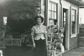
Highland Park station dinky store
https://search.heritageburnaby.ca/link/archivedescription35770
- Repository
- City of Burnaby Archives
- Date
- 1935
- Collection/Fonds
- Burnaby Historical Society fonds
- Description Level
- Item
- Physical Description
- 1 photograph : b&w ; 12.7 x 17.8 cm print
- Scope and Content
- Photograph of the "dinky" store (so-called because of its small size) at Highland Park Interurban station at Buller Avenue. In front: Margaret Thould. Lionel Thould, who opened this store, later opened a similar store at Fraser Arm Interurban station and gave up the Highland Park store when buses…
- Repository
- City of Burnaby Archives
- Date
- 1935
- Collection/Fonds
- Burnaby Historical Society fonds
- Subseries
- Pioneer Tales subseries
- Physical Description
- 1 photograph : b&w ; 12.7 x 17.8 cm print
- Description Level
- Item
- Record No.
- 204-628
- Access Restriction
- No restrictions
- Reproduction Restriction
- No known restrictions
- Accession Number
- BHS1988-03
- Scope and Content
- Photograph of the "dinky" store (so-called because of its small size) at Highland Park Interurban station at Buller Avenue. In front: Margaret Thould. Lionel Thould, who opened this store, later opened a similar store at Fraser Arm Interurban station and gave up the Highland Park store when buses replaced first street cars, then Interurban trams.
- Media Type
- Photograph
- Notes
- Title based on contents of photograph
- Geographic Access
- Buller Avenue
- Central Park Interurban line
- Planning Study Area
- Windsor Area
Images

![After 8 café, [2004] thumbnail](/media/hpo/_Data/_Archives_Images/_Unrestricted/535/535-1767-1.jpg?width=280)
After 8 café
https://search.heritageburnaby.ca/link/archivedescription96016
- Repository
- City of Burnaby Archives
- Date
- [2004]
- Collection/Fonds
- Burnaby NewsLeader photograph collection
- Description Level
- File
- Physical Description
- 2 photographs (tiff) : col.
- Scope and Content
- File contains photographs of Nilesh Bhathella, cardiologist and owner of the After 8 café in North Burnaby, seated at a bar counter inside of a café.
- Repository
- City of Burnaby Archives
- Date
- [2004]
- Collection/Fonds
- Burnaby NewsLeader photograph collection
- Physical Description
- 2 photographs (tiff) : col.
- Description Level
- File
- Record No.
- 535-1767
- Access Restriction
- No restrictions
- Reproduction Restriction
- No restrictions
- Accession Number
- 2018-12
- Scope and Content
- File contains photographs of Nilesh Bhathella, cardiologist and owner of the After 8 café in North Burnaby, seated at a bar counter inside of a café.
- Subjects
- Buildings - Commercial - Restaurants
- Media Type
- Photograph
- Photographer
- Bartel, Mario
- Notes
- Title based on caption
- Collected by editorial for use in a January 2004 issue of the Burnaby NewsLeader
- Caption from metadata: "Nilesh Bhathella is taking a break from his career as a cardiologist to open a new cafe in North Burnaby, After 8."
Images
![After 8 café, [2004] thumbnail](/media/hpo/_Data/_Archives_Images/_Unrestricted/535/535-1767-1.jpg)
![Boil water advisory at the Hop & Vine Neighbourhood Pub, [2001] thumbnail](/media/hpo/_Data/_Archives_Images/_Unrestricted/535/535-1655.jpg?width=280)
Boil water advisory at the Hop & Vine Neighbourhood Pub
https://search.heritageburnaby.ca/link/archivedescription95855
- Repository
- City of Burnaby Archives
- Date
- [2001]
- Collection/Fonds
- Burnaby NewsLeader photograph collection
- Description Level
- Item
- Physical Description
- 1 photograph (tiff) : col.
- Scope and Content
- Photograph of a bar manager holding up a glass of tap water to inspect it. Bottles of liquor on the bar shelf are visible in the background.
- Repository
- City of Burnaby Archives
- Date
- [2001]
- Collection/Fonds
- Burnaby NewsLeader photograph collection
- Physical Description
- 1 photograph (tiff) : col.
- Description Level
- Item
- Record No.
- 535-1655
- Access Restriction
- No restrictions
- Reproduction Restriction
- No restrictions
- Accession Number
- 2018-12
- Scope and Content
- Photograph of a bar manager holding up a glass of tap water to inspect it. Bottles of liquor on the bar shelf are visible in the background.
- Subjects
- Buildings - Commercial - Restaurants
- Media Type
- Photograph
- Photographer
- Bartel, Mario
- Notes
- Title based on caption
- Collected by editorial for use in a March 2001 issue of the Burnaby NewsLeader
- Caption from metadata: "Binnie Nastasi, the general manager of the Hop & Vine Neighborhood Pub, checks the tap water after residents and businesses in the area around Burnaby Mountain Golf Course had to endure a two-day boil water advisory."
- Planning Study Area
- Burnaby Mountain Area
Images
![Boil water advisory at the Hop & Vine Neighbourhood Pub, [2001] thumbnail](/media/hpo/_Data/_Archives_Images/_Unrestricted/535/535-1655.jpg)
![Chef John Garrett, [2002] thumbnail](/media/hpo/_Data/_Archives_Images/_Unrestricted/535/535-2806.jpg?width=280)
Chef John Garrett
https://search.heritageburnaby.ca/link/archivedescription97467
- Repository
- City of Burnaby Archives
- Date
- [2002]
- Collection/Fonds
- Burnaby NewsLeader photograph collection
- Description Level
- Item
- Physical Description
- 1 photograph (tiff) : col.
- Scope and Content
- Photograph of John Garrett, the head chef at Horizon's Restaurant, roasting peppers in the restaurant's kitchen.
- Repository
- City of Burnaby Archives
- Date
- [2002]
- Collection/Fonds
- Burnaby NewsLeader photograph collection
- Physical Description
- 1 photograph (tiff) : col.
- Description Level
- Item
- Record No.
- 535-2806
- Access Restriction
- No restrictions
- Reproduction Restriction
- No restrictions
- Accession Number
- 2018-12
- Scope and Content
- Photograph of John Garrett, the head chef at Horizon's Restaurant, roasting peppers in the restaurant's kitchen.
- Media Type
- Photograph
- Photographer
- Bartel, Mario
- Notes
- Title based on caption
- Collected by editorial for use in an October 2002 issue of the Burnaby NewsLeader
- Caption from metadata: "John Garrett, the head chef at Horizon's Restaurant on Burnaby Mountain, has just published his first book, featuring favorite recipes of dishes from the restaurant."
- Geographic Access
- Burnaby Mountain Conservation Area
- Centennial Way
- Street Address
- 100 Centennial Way
- Planning Study Area
- Burnaby Mountain Area
Images
![Chef John Garrett, [2002] thumbnail](/media/hpo/_Data/_Archives_Images/_Unrestricted/535/535-2806.jpg)
![Frank Abbinante at Puglia Cheese, [2001] thumbnail](/media/hpo/_Data/_Archives_Images/_Unrestricted/535/535-2973.jpg?width=280)
Frank Abbinante at Puglia Cheese
https://search.heritageburnaby.ca/link/archivedescription97698
- Repository
- City of Burnaby Archives
- Date
- [2001]
- Collection/Fonds
- Burnaby NewsLeader photograph collection
- Description Level
- Item
- Physical Description
- 1 photograph (tiff) : col.
- Scope and Content
- Photograph of chef Frank Abbinante cooking tortellini in a sauce at Puglia Cheese on Hastings Street.
- Repository
- City of Burnaby Archives
- Date
- [2001]
- Collection/Fonds
- Burnaby NewsLeader photograph collection
- Physical Description
- 1 photograph (tiff) : col.
- Description Level
- Item
- Record No.
- 535-2973
- Access Restriction
- No restrictions
- Reproduction Restriction
- No restrictions
- Accession Number
- 2018-12
- Scope and Content
- Photograph of chef Frank Abbinante cooking tortellini in a sauce at Puglia Cheese on Hastings Street.
- Media Type
- Photograph
- Photographer
- Bartel, Mario
- Notes
- Title based on caption
- Collected by editorial for use in a December 2001 issue of the Burnaby NewsLeader
- Caption from metadata: "Frank Abbinante cooks up tortellini in a tomato/basil sauce at Puglia Cheese on Hastings St. in North Burnaby."
- Geographic Access
- Hastings Street
- Street Address
- 6011 Hastings Street
- Historic Neighbourhood
- Capitol Hill (Historic Neighbourhood)
- Planning Study Area
- Capitol Hill Area
Images
![Frank Abbinante at Puglia Cheese, [2001] thumbnail](/media/hpo/_Data/_Archives_Images/_Unrestricted/535/535-2973.jpg)
![Hafez Tea House, [2005] thumbnail](/media/hpo/_Data/_Archives_Images/_Unrestricted/535/535-1855.jpg?width=280)
Hafez Tea House
https://search.heritageburnaby.ca/link/archivedescription96158
- Repository
- City of Burnaby Archives
- Date
- [2005]
- Collection/Fonds
- Burnaby NewsLeader photograph collection
- Description Level
- Item
- Physical Description
- 1 photograph (tiff) : col.
- Scope and Content
- Photograph of Abbas Adibi, owner of the Hafez Tea House on Hastings Street, seated at a table and smoking from a hookah.
- Repository
- City of Burnaby Archives
- Date
- [2005]
- Collection/Fonds
- Burnaby NewsLeader photograph collection
- Physical Description
- 1 photograph (tiff) : col.
- Description Level
- Item
- Record No.
- 535-1855
- Access Restriction
- No restrictions
- Reproduction Restriction
- No restrictions
- Accession Number
- 2018-12
- Scope and Content
- Photograph of Abbas Adibi, owner of the Hafez Tea House on Hastings Street, seated at a table and smoking from a hookah.
- Media Type
- Photograph
- Photographer
- Bartel, Mario
- Notes
- Title based on caption
- Collected by editorial for use in a January 2005 issue of the Burnaby NewsLeader
- Caption from metadata: "Abbas Adibi enjoys a smoke on a traditional Persian hookah water pipe at his North Burnaby cafe, The Hafez Tea House. He says his establishment should be exempt from smoking bylaws and Worker's Compensation Board regulations because socializing around a hookah is an integral part of Persian culture, and there are few carcinogens in the smoke."
- Geographic Access
- Hastings Street
- Street Address
- 6649 Hastings Street
- Historic Neighbourhood
- Lochdale (Historic Neighbourhood)
- Planning Study Area
- Westridge Area
Images
![Hafez Tea House, [2005] thumbnail](/media/hpo/_Data/_Archives_Images/_Unrestricted/535/535-1855.jpg)
![Myles of Beans Cafe & Coffee House, [2002] thumbnail](/media/hpo/_Data/_Archives_Images/_Unrestricted/535/535-2340.jpg?width=280)
Myles of Beans Cafe & Coffee House
https://search.heritageburnaby.ca/link/archivedescription96741
- Repository
- City of Burnaby Archives
- Date
- [2002]
- Collection/Fonds
- Burnaby NewsLeader photograph collection
- Description Level
- Item
- Physical Description
- 1 photograph (tiff) : col.
- Scope and Content
- Photograph of Kim Mostat posing outside of Myles of Beans Cafe & Coffee House on Kingsway & Griffiths Avenue. Mostat holds a musical instrument case and the cafe's sign is visible behind Mostat.
- Repository
- City of Burnaby Archives
- Date
- [2002]
- Collection/Fonds
- Burnaby NewsLeader photograph collection
- Physical Description
- 1 photograph (tiff) : col.
- Description Level
- Item
- Record No.
- 535-2340
- Access Restriction
- No restrictions
- Reproduction Restriction
- No restrictions
- Accession Number
- 2018-12
- Scope and Content
- Photograph of Kim Mostat posing outside of Myles of Beans Cafe & Coffee House on Kingsway & Griffiths Avenue. Mostat holds a musical instrument case and the cafe's sign is visible behind Mostat.
- Media Type
- Photograph
- Photographer
- Bartel, Mario
- Notes
- Title based on caption
- Collected by editorial for use in a May 2002 issue of the Burnaby NewsLeader
- Caption from metadata: "Kim Mostat, the owner of Myles of Beans Cafe, in Burnaby's Middletown area has kept her coffee shop alive as a venue for local musicians and poets to perform their works."
- Geographic Access
- Kingsway
- Historic Neighbourhood
- Edmonds (Historic Neighbourhood)
- Planning Study Area
- Stride Avenue Area
Images
![Myles of Beans Cafe & Coffee House, [2002] thumbnail](/media/hpo/_Data/_Archives_Images/_Unrestricted/535/535-2340.jpg)