Narrow Results By

Bird's Eye View of the Burnaby Lake Area
https://search.heritageburnaby.ca/link/museumdescription15144
- Repository
- Burnaby Village Museum
- Date
- 1977
- Collection/Fonds
- Century Park Museum Association fonds
- Description Level
- Item
- Physical Description
- 1 map : b&w print on paper ; 43 x 63.5 cm
- Scope and Content
- Item consists of a map titled "Birds Eye View of the Burnaby Lake Area Circa 1910". The overview of the Burnaby Lake area was compiled and drawn at Heritage Village by curator John Adams and artist, Carol Swan. The map identifies the Burnaby Lake inter-urban tram line; roads including: Sperling Ave…
- Repository
- Burnaby Village Museum
- Collection/Fonds
- Century Park Museum Association fonds
- Description Level
- Item
- Physical Description
- 1 map : b&w print on paper ; 43 x 63.5 cm
- Material Details
- Scale indeterminable
- Scope and Content
- Item consists of a map titled "Birds Eye View of the Burnaby Lake Area Circa 1910". The overview of the Burnaby Lake area was compiled and drawn at Heritage Village by curator John Adams and artist, Carol Swan. The map identifies the Burnaby Lake inter-urban tram line; roads including: Sperling Avenue (Pole Line Road); Gilpin Avenue; Douglas Road; trail to Vancouver Westminster Road (Kingsway); Buckingham Avenue; Haszard Street; various farms and residences including: Charles Sprott "Norland"; H.T. Ceperley "Fairacres"; Claude Hill's "Brookfield farm" and "Broadview"; F.J. Hart's "Avalon"; Miss Woodward's former and new home, school and post office; Councillor Edgar's hunting cabin; Edgar Sprott's "Mayfield farm" and "Mayfield Lodge"; F.J. Peers "Greyfriars"; Arthur de Windt Haszard; Bernard Hill's boathouse as well as other landmarks including: Doran's Mill; tram stations; Burnaby Lake Store; logging camps; wood cutter's shacks; ice houses; cranberry bog; Still Creek; Deer Lake; Burnaby Lake; Deer Lake Creek; Provincial Government Reserve Proposed Hospital (later Oakalla Prison).
- Creator
- Adams, John
- Swan, Carol
- Names
- Hill, Arthur Claude
- Sprott, Charles Frederick
- Sprott, Louis "Edgar"
- Hart, Frederick John, 1884-1945
- Ceperley, H.T.
- Woodward, Maude
- Woodward, Harriet
- Peers, Francis J.
- Haszard, Arthur de Windt
- Hill, Bernard R.
- Geographic Access
- Deer Lake Avenue
- Sperling Avenue
- Haszard Street
- Buckingham Avenue
- Accession Code
- BV021.1.3
- Access Restriction
- No restrictions
- Reproduction Restriction
- No known restrictions
- Date
- 1977
- Media Type
- Cartographic Material
- Historic Neighbourhood
- Burnaby Lake (Historic Neighbourhood)
- Planning Study Area
- Burnaby Lake Area
- Related Material
- See also: Life with the Moores of Hart House : pioneer days on Burnaby's Deer Lake
- Scan Resolution
- 600
- Scan Date
- 2021-11-12
- Scale
- 100
- Notes
- Transcribed title
- Compiled by John Adams; illustration by Carol Swan
- The map depicts the Burnaby Lake Tram Line as being double tracked, whereas in reality it was single tracked.
- Map is part of the book "Life with the Moores of Hart House : pioneer days on Burnaby's Deer Lake https://search.heritageburnaby.ca/permalink/museumlibrary6314-102
Images


Bird's Eye View of the Burnaby Lake Area
https://search.heritageburnaby.ca/link/museumdescription17543
- Repository
- Burnaby Village Museum
- Date
- 1977
- Collection/Fonds
- Century Park Museum Association fonds
- Description Level
- Item
- Physical Description
- 1 map : b&w print with watercolour ; 43 x 63.5 cm
- Scope and Content
- Item consists of a map titled "Birds Eye View of the Burnaby Lake Area Circa 1910". The overview of the Burnaby Lake area was compiled and drawn at Heritage Village by curator John Adams and artist, Carol Swan. The map identifies the Burnaby Lake inter-urban tram line; roads including: Sperling Ave…
- Repository
- Burnaby Village Museum
- Collection/Fonds
- Century Park Museum Association fonds
- Description Level
- Item
- Physical Description
- 1 map : b&w print with watercolour ; 43 x 63.5 cm
- Material Details
- Scale indeterminable
- Scope and Content
- Item consists of a map titled "Birds Eye View of the Burnaby Lake Area Circa 1910". The overview of the Burnaby Lake area was compiled and drawn at Heritage Village by curator John Adams and artist, Carol Swan. The map identifies the Burnaby Lake inter-urban tram line; roads including: Sperling Avenue (Pole Line Road); Gilpin Avenue; Douglas Road; trail to Vancouver Westminster Road (Kingsway); Buckingham Avenue; Haszard Street; various farms and residences including: Charles Sprott "Norland"; H.T. Ceperley "Fairacres"; Claude Hill's "Brookfield farm" and "Broadview"; F.J. Hart's "Avalon"; Miss Woodward's former and new home, school and post office; Councillor Edgar's hunting cabin; Edgar Sprott's "Mayfield farm" and "Mayfield Lodge"; F.J. Peers "Greyfriars"; Arthur de Windt Haszard; Bernard Hill's boathouse as well as other landmarks including: Doran's Mill; tram stations; Burnaby Lake Store; logging camps; wood cutter's shacks; ice houses; cranberry bog; Still Creek; Deer Lake; Burnaby Lake; Deer Lake Creek; Provincial Government Reserve Proposed Hospital (later Oakalla Prison).
- Creator
- Adams, John
- Swan, Carol
- Names
- Hill, Arthur Claude
- Sprott, Charles Frederick
- Sprott, Louis "Edgar"
- Hart, Frederick John, 1884-1945
- Ceperley, H.T.
- Woodward, Maude
- Woodward, Harriet
- Peers, Francis J.
- Haszard, Arthur de Windt
- Hill, Bernard R.
- Geographic Access
- Deer Lake Avenue
- Sperling Avenue
- Haszard Street
- Buckingham Avenue
- Accession Code
- BV021.1.4
- Access Restriction
- No restrictions
- Reproduction Restriction
- No known restrictions
- Date
- 1977
- Media Type
- Cartographic Material
- Historic Neighbourhood
- Burnaby Lake (Historic Neighbourhood)
- Planning Study Area
- Burnaby Lake Area
- Related Material
- See also: Life with the Moores of Hart House : pioneer days on Burnaby's Deer Lake
- Scan Resolution
- 600
- Scan Date
- 2021-11-12
- Scale
- 100
- Notes
- Transcribed title
- Compiled by John Adams; illustration by Carol Swan
- The map depicts the Burnaby Lake Tram Line as being double tracked, whereas in reality it was single tracked.
- Map is part of the book "Life with the Moores of Hart House : pioneer days on Burnaby's Deer Lake https://search.heritageburnaby.ca/permalink/museumlibrary6314-102
- This is a print made from original illustration and appears to be hand-coloured with watercolour at a later date.
Images

![Brunette River dam, [1930] (date of original), copied 1986 thumbnail](/media/hpo/_Data/_Archives_Images/_Unrestricted/204/204-325.jpg?width=280)
Brunette River dam
https://search.heritageburnaby.ca/link/archivedescription35467
- Repository
- City of Burnaby Archives
- Date
- [1930] (date of original), copied 1986
- Collection/Fonds
- Burnaby Historical Society fonds
- Description Level
- Item
- Physical Description
- 1 photograph : b&w ; 12.7 x 17.8 cm print
- Scope and Content
- Photograph of the Brunette River dam. The Picken family home, "Aintree," is faintly visible in the background, with the mailing address of 2600 Cariboo Road, R.R. 2, New Westminster. The number was later changed to 6825 Cariboo Road, and the mail redirected through Burnaby. The Picken family cons…
- Repository
- City of Burnaby Archives
- Date
- [1930] (date of original), copied 1986
- Collection/Fonds
- Burnaby Historical Society fonds
- Subseries
- Pioneer Tales subseries
- Physical Description
- 1 photograph : b&w ; 12.7 x 17.8 cm print
- Description Level
- Item
- Record No.
- 204-325
- Access Restriction
- No restrictions
- Reproduction Restriction
- No known restrictions
- Accession Number
- BHS1988-03
- Scope and Content
- Photograph of the Brunette River dam. The Picken family home, "Aintree," is faintly visible in the background, with the mailing address of 2600 Cariboo Road, R.R. 2, New Westminster. The number was later changed to 6825 Cariboo Road, and the mail redirected through Burnaby. The Picken family consisted of Stanley B. Picken (dam keeper on the Brunette River), his wife Isabel Picken (nee Ponton) and their children.
- Media Type
- Photograph
- Notes
- Title based on contents of photograph
- Geographic Access
- Cariboo Road
- Street Address
- 6825 Cariboo Road
- Historic Neighbourhood
- Burquitlam (Historic Neighbourhood)
- Planning Study Area
- Burnaby Lake Area
Images
![Brunette River dam, [1930] (date of original), copied 1986 thumbnail](/media/hpo/_Data/_Archives_Images/_Unrestricted/204/204-325.jpg)
![Cariboo Cloverleaf, Government Road and Gaglardi Way, [1978] thumbnail](/media/hpo/_Data/_Archives_Images/_Unrestricted/480/480-274.jpg?width=280)
Cariboo Cloverleaf, Government Road and Gaglardi Way
https://search.heritageburnaby.ca/link/archivedescription45379
- Repository
- City of Burnaby Archives
- Date
- [1978]
- Collection/Fonds
- Columbian Newspaper collection
- Description Level
- Item
- Physical Description
- 1 photograph : b&w ; 22.5 x 19 cm
- Scope and Content
- Aerial photograph of the Cariboo Cloverleaf, and the Government Road overpass construction that would join it with Gaglardi Way.
- Repository
- City of Burnaby Archives
- Date
- [1978]
- Collection/Fonds
- Columbian Newspaper collection
- Physical Description
- 1 photograph : b&w ; 22.5 x 19 cm
- Description Level
- Item
- Record No.
- 480-274
- Access Restriction
- No restrictions
- Reproduction Restriction
- No restrictions
- Accession Number
- 2003-02
- Scope and Content
- Aerial photograph of the Cariboo Cloverleaf, and the Government Road overpass construction that would join it with Gaglardi Way.
- Media Type
- Photograph
- Photographer
- King, Basil
- Notes
- Title based on contents of photograph
- Note on recto of photograph reads: "Cariboo cloverleaf in foreground and Government Road overpass construction (centre) will join with Gaglardi Way (top of pic)."
- Geographic Access
- Government Road
- Cariboo Road
- Gaglardi Way
- Historic Neighbourhood
- Burquitlam (Historic Neighbourhood)
- Planning Study Area
- Burnaby Lake Area
- Cariboo-Armstrong Area
- Cameron Area
Images
![Cariboo Cloverleaf, Government Road and Gaglardi Way, [1978] thumbnail](/media/hpo/_Data/_Archives_Images/_Unrestricted/480/480-274.jpg)

Cariboo Road Overpass
https://search.heritageburnaby.ca/link/archivedescription45378
- Repository
- City of Burnaby Archives
- Date
- 1977
- Collection/Fonds
- Columbian Newspaper collection
- Description Level
- Item
- Physical Description
- 1 photograph : b&w ; 12.5 x 24 cm
- Scope and Content
- Photograph of the Cariboo Road Overpass at the begining stage of its construction.
- Repository
- City of Burnaby Archives
- Date
- 1977
- Collection/Fonds
- Columbian Newspaper collection
- Physical Description
- 1 photograph : b&w ; 12.5 x 24 cm
- Description Level
- Item
- Record No.
- 480-273
- Access Restriction
- No restrictions
- Reproduction Restriction
- No restrictions
- Accession Number
- 2003-02
- Scope and Content
- Photograph of the Cariboo Road Overpass at the begining stage of its construction.
- Subjects
- Construction - Road Construction
- Media Type
- Photograph
- Photographer
- Hodge, Craig
- Notes
- Title based on contents of photograph
- Newspaper clipping attached to verso of photograph reads: "Road builders created a sandpile for a giant with the first stage of the $917, 000 Cariboo Rd. overpass in Burnaby. Started several weeks ago the overpass actually consists of two bridges - one crossing railway tracks and Government St., the other spanning the Brunette River - and is expected to be complete early next year."
- Geographic Access
- Cariboo Road
- Trans Canada Highway
- Planning Study Area
- Burnaby Lake Area
Images


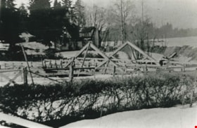
Construction of the Caribou Road to freeway link-up
https://search.heritageburnaby.ca/link/archivedescription45363
- Repository
- City of Burnaby Archives
- Date
- September 1977
- Collection/Fonds
- Columbian Newspaper collection
- Description Level
- Item
- Physical Description
- 1 photograph : b&w ; 10.5 x 18.5 cm
- Scope and Content
- Photograph of the construction of the Cariboo Road to 401 Freeway link-up. This was built in an effort to "ease [the] bottleneck of traffic at Stormount [sic] Interchange." The 401 Freeway is now known as the Trans Canada Highway.
- Repository
- City of Burnaby Archives
- Date
- September 1977
- Collection/Fonds
- Columbian Newspaper collection
- Physical Description
- 1 photograph : b&w ; 10.5 x 18.5 cm
- Description Level
- Item
- Record No.
- 480-258
- Access Restriction
- No restrictions
- Reproduction Restriction
- No restrictions
- Accession Number
- 2003-02
- Scope and Content
- Photograph of the construction of the Cariboo Road to 401 Freeway link-up. This was built in an effort to "ease [the] bottleneck of traffic at Stormount [sic] Interchange." The 401 Freeway is now known as the Trans Canada Highway.
- Subjects
- Construction - Road Construction
- Media Type
- Photograph
- Photographer
- Hodge, Craig
- Notes
- Title based on contents of photograph
- Newspaper clipping attached to verso of photograph reads: "Construction is now well underway on the new Caribou Road-freeway link-up which will ease bottleneck of traffic at Stormount [sic] Interchange."
- Geographic Access
- Trans Canada Highway
- Cariboo Road
- Planning Study Area
- Burnaby Lake Area
- Cariboo-Armstrong Area
Images

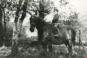
Mary Picken
https://search.heritageburnaby.ca/link/archivedescription35470
- Repository
- City of Burnaby Archives
- Date
- 1930 (date of original), copied 1986
- Collection/Fonds
- Burnaby Historical Society fonds
- Description Level
- Item
- Physical Description
- 1 photograph : b&w ; 12.7 x 17.8 cm print
- Scope and Content
- Photograph of Mary Picken (later Mary Healy) with her favourite riding horse, Foxy. Mary was the daughter of Stanley B. Picken and Isabel Picken.
- Repository
- City of Burnaby Archives
- Date
- 1930 (date of original), copied 1986
- Collection/Fonds
- Burnaby Historical Society fonds
- Subseries
- Pioneer Tales subseries
- Physical Description
- 1 photograph : b&w ; 12.7 x 17.8 cm print
- Description Level
- Item
- Record No.
- 204-328
- Access Restriction
- No restrictions
- Reproduction Restriction
- No known restrictions
- Accession Number
- BHS1988-03
- Scope and Content
- Photograph of Mary Picken (later Mary Healy) with her favourite riding horse, Foxy. Mary was the daughter of Stanley B. Picken and Isabel Picken.
- Subjects
- Animals - Horses
- Names
- Healy, Mary Picken
- Media Type
- Photograph
- Notes
- Title based on contents of photograph
- Geographic Access
- Cariboo Road
- Street Address
- 6825 Cariboo Road
- Historic Neighbourhood
- Burquitlam (Historic Neighbourhood)
- Planning Study Area
- Burnaby Lake Area
Images

Picken family home
https://search.heritageburnaby.ca/link/archivedescription35468
- Repository
- City of Burnaby Archives
- Date
- 1931 (date of original), copied 1986
- Collection/Fonds
- Burnaby Historical Society fonds
- Description Level
- Item
- Physical Description
- 1 photograph : b&w ; 12.7 x 17.8 cm print
- Scope and Content
- Photograph of the Picken family home, "Aintree" by the Brunette River, with the mailing address of 2600 Cariboo Road, R.R. 2, New Westminster. The number was later changed to 6825 Cariboo Road, and the mail redirected through Burnaby. The Picken family consisted of Stanley B. Picken (dam keeper …
- Repository
- City of Burnaby Archives
- Date
- 1931 (date of original), copied 1986
- Collection/Fonds
- Burnaby Historical Society fonds
- Subseries
- Pioneer Tales subseries
- Physical Description
- 1 photograph : b&w ; 12.7 x 17.8 cm print
- Description Level
- Item
- Record No.
- 204-326
- Access Restriction
- No restrictions
- Reproduction Restriction
- No known restrictions
- Accession Number
- BHS1988-03
- Scope and Content
- Photograph of the Picken family home, "Aintree" by the Brunette River, with the mailing address of 2600 Cariboo Road, R.R. 2, New Westminster. The number was later changed to 6825 Cariboo Road, and the mail redirected through Burnaby. The Picken family consisted of Stanley B. Picken (dam keeper on the Brunette River), his wife Isabel Picken (formerly Isabel Ponton) and their children.
- Media Type
- Photograph
- Notes
- Title based on contents of photograph
- Geographic Access
- Cariboo Road
- Street Address
- 6825 Cariboo Road
- Historic Neighbourhood
- Burquitlam (Historic Neighbourhood)
- Planning Study Area
- Burnaby Lake Area
Images


Stormont Overpass
https://search.heritageburnaby.ca/link/archivedescription45376
- Repository
- City of Burnaby Archives
- Date
- August 1978
- Collection/Fonds
- Columbian Newspaper collection
- Description Level
- Item
- Physical Description
- 1 photograph : b&w ; 12.5 x 24 cm
- Scope and Content
- Aerial photograph of Stormont Overpass which would provide a direct link from the Trans Canada Highway (previously named the 401 Freeway) to the Lougheed Highway and Simon Fraser University. This was taken when the excavation work was completed, and grading and paving still need to be done.
- Repository
- City of Burnaby Archives
- Date
- August 1978
- Collection/Fonds
- Columbian Newspaper collection
- Physical Description
- 1 photograph : b&w ; 12.5 x 24 cm
- Description Level
- Item
- Record No.
- 480-271
- Access Restriction
- No restrictions
- Reproduction Restriction
- No restrictions
- Accession Number
- 2003-02
- Scope and Content
- Aerial photograph of Stormont Overpass which would provide a direct link from the Trans Canada Highway (previously named the 401 Freeway) to the Lougheed Highway and Simon Fraser University. This was taken when the excavation work was completed, and grading and paving still need to be done.
- Media Type
- Photograph
- Photographer
- Hodge, Craig
- Notes
- Title based on contents of photograph
- Note in pencil on verso of photograph reads: "Altair Aviation / photo by / Craig Hodge"
- Geographic Access
- Cariboo Road
- Gaglardi Way
- Trans Canada Highway
- Historic Neighbourhood
- Burquitlam (Historic Neighbourhood)
- Planning Study Area
- Burnaby Lake Area
- Cameron Area
Images


Stormont Overpass
https://search.heritageburnaby.ca/link/archivedescription45377
- Repository
- City of Burnaby Archives
- Date
- August 1978
- Collection/Fonds
- Columbian Newspaper collection
- Description Level
- Item
- Physical Description
- 1 photograph : b&w ; 16.5 x 24 cm
- Scope and Content
- Aerial photograph of Stormont Overpass which would provide a direct link from the 401 Freeway to the Lougheed Highway and Simon Fraser University. This was taken when the excavation work was completed, and grading and paving still need to be done.
- Repository
- City of Burnaby Archives
- Date
- August 1978
- Collection/Fonds
- Columbian Newspaper collection
- Physical Description
- 1 photograph : b&w ; 16.5 x 24 cm
- Description Level
- Item
- Record No.
- 480-272
- Access Restriction
- No restrictions
- Reproduction Restriction
- No restrictions
- Accession Number
- 2003-02
- Scope and Content
- Aerial photograph of Stormont Overpass which would provide a direct link from the 401 Freeway to the Lougheed Highway and Simon Fraser University. This was taken when the excavation work was completed, and grading and paving still need to be done.
- Media Type
- Photograph
- Photographer
- Hodge, Craig
- Notes
- Title based on contents of photograph
- Newspaper clipping attached to verso of photograph reads: "After six years, work on the Stormont interchange in Burnaby is only a few weeks from completion. The huge clover-leaf junction of Gaglardi Way and the Freeway is on the top left-hand corner, with Gaglardi Way approaching from the bottom right where a bridge has been completed over the Burlington Northern tracks. An embankment linking that bridge with one over the Brunette River awaits only a layer of tarmac, and a path has been cleared through the woods to link up with the clover-leaf. The present access to the Freeway is along the road running from the left to right across the middle of the picture. The interchange will open next month."
- Note in pencil on verso of photograph reads: "Altair Aviation / photo by / Craig Hodge"
- Geographic Access
- Cariboo Road
- Gaglardi Way
- Trans Canada Highway
- Historic Neighbourhood
- Burquitlam (Historic Neighbourhood)
- Planning Study Area
- Burnaby Lake Area
- Cameron Area
Images

![Stormont Overpass, [1978] thumbnail](/media/hpo/_Data/_Archives_Images/_Unrestricted/480/480-275.jpg?width=280)
Stormont Overpass
https://search.heritageburnaby.ca/link/archivedescription45380
- Repository
- City of Burnaby Archives
- Date
- [1978]
- Collection/Fonds
- Columbian Newspaper collection
- Description Level
- Item
- Physical Description
- 1 photograph : b&w ; 16 x 24 cm
- Scope and Content
- Aerial photograph of Stormont Overpass which would provide a direct link from the Trans Canada Highway (previously named the 401 Freeway) to the Lougheed Highway and Simon Fraser University. This was taken when the excavation work was completed, and paving still need to be done.
- Repository
- City of Burnaby Archives
- Date
- [1978]
- Collection/Fonds
- Columbian Newspaper collection
- Physical Description
- 1 photograph : b&w ; 16 x 24 cm
- Description Level
- Item
- Record No.
- 480-275
- Access Restriction
- No restrictions
- Reproduction Restriction
- No restrictions
- Accession Number
- 2003-02
- Scope and Content
- Aerial photograph of Stormont Overpass which would provide a direct link from the Trans Canada Highway (previously named the 401 Freeway) to the Lougheed Highway and Simon Fraser University. This was taken when the excavation work was completed, and paving still need to be done.
- Media Type
- Photograph
- Photographer
- King, Basil
- Notes
- Title based on contents of photograph
- Note on verso of photograph reads: "One of the biggest Highways"
- Geographic Access
- Cariboo Road
- Gaglardi Way
- Trans Canada Highway
- Historic Neighbourhood
- Burquitlam (Historic Neighbourhood)
- Planning Study Area
- Burnaby Lake Area
- Cameron Area
Images
![Stormont Overpass, [1978] thumbnail](/media/hpo/_Data/_Archives_Images/_Unrestricted/480/480-275.jpg)