Narrow Results By
Subject
- Advertising Medium - Signs and Signboards 1
- Aerial Photographs 12
- Agriculture - Fruit and Berries 1
- Animals 4
- Animals - Cats 2
- Animals - Dogs 3
- Buildings - Commercial - General Stores 1
- Buildings - Commercial - Service Stations 2
- Buildings - Recreational 1
- Buildings - Residential - Cabins 1
- Buildings - Residential - Houses 6
- Buildings - Schools 2

Academic Quadrangle construction
https://search.heritageburnaby.ca/link/archivedescription38215
- Repository
- City of Burnaby Archives
- Date
- August 5, 1966 (date of original), copied 1991
- Collection/Fonds
- Burnaby Historical Society fonds
- Description Level
- Item
- Physical Description
- 1 photograph : b&w ; 3.3 x 4.1 cm print on contact sheet 20.5 x 26.8 cm
- Scope and Content
- Photograph of the construction of the Simon Fraser University (SFU) Academic Quadrangle building, phase two. Information at lower right corner of photograph reads, "Academic Quadrangle Building / Phase Two / Simon Fraser University, Burnaby, BC / Z.S. Kiss - Architect / Laing Construction & Equipme…
- Repository
- City of Burnaby Archives
- Date
- August 5, 1966 (date of original), copied 1991
- Collection/Fonds
- Burnaby Historical Society fonds
- Subseries
- Burnaby Image Bank subseries
- Physical Description
- 1 photograph : b&w ; 3.3 x 4.1 cm print on contact sheet 20.5 x 26.8 cm
- Description Level
- Item
- Record No.
- 370-802
- Access Restriction
- No restrictions
- Reproduction Restriction
- No restrictions
- Accession Number
- BHS1999-03
- Scope and Content
- Photograph of the construction of the Simon Fraser University (SFU) Academic Quadrangle building, phase two. Information at lower right corner of photograph reads, "Academic Quadrangle Building / Phase Two / Simon Fraser University, Burnaby, BC / Z.S. Kiss - Architect / Laing Construction & Equipment Ltd, General Contractors / No14 Date Aug 5, 1966, Facing E."
- Media Type
- Photograph
- Photographer
- Frank, Leonard
- Notes
- Title based on contents of photograph
- 1 b&w copy negative accompanying
- Geographic Access
- University Drive
- Street Address
- 8888 University Drive
- Planning Study Area
- Burnaby Mountain Area
Images


Across the inlet from Barnet
https://search.heritageburnaby.ca/link/museumdescription15222
- Repository
- Burnaby Village Museum
- Date
- July 1934 (date of original), copied 2004
- Collection/Fonds
- In the Shadow by the Sea collection
- Description Level
- Item
- Physical Description
- 1 photograph (tiff) : 300 dpi
- Scope and Content
- Photograph looking across Burrard Inlet from the Village of Barnet. The rugged coastline of the north shore of the inlet is visible with rock formations and forest.
- Repository
- Burnaby Village Museum
- Collection/Fonds
- In the Shadow by the Sea collection
- Description Level
- Item
- Physical Description
- 1 photograph (tiff) : 300 dpi
- Material Details
- Original photograph appears to be hand coloured
- Scope and Content
- Photograph looking across Burrard Inlet from the Village of Barnet. The rugged coastline of the north shore of the inlet is visible with rock formations and forest.
- Subjects
- Geographic Features - Inlets
- Geographic Features - Rock Formations
- Geographic Features - Forests
- Geographic Access
- Burrard Inlet
- Accession Code
- BV019.32.42
- Access Restriction
- No restrictions
- Reproduction Restriction
- No known restrictions
- Date
- July 1934 (date of original), copied 2004
- Media Type
- Photograph
- Historic Neighbourhood
- Barnet (Historic Neighbourhood)
- Planning Study Area
- Burnaby Mountain Area
- Notes
- Title based on contents of photograph
Images

Aerial photograph of Burnaby
https://search.heritageburnaby.ca/link/archivedescription84894
- Repository
- City of Burnaby Archives
- Date
- 1963
- Collection/Fonds
- Allan Amundsen collection
- Description Level
- Item
- Physical Description
- 1 photograph : b&w ; 22.5 x 22.5 cm
- Scope and Content
- Aerial photograph of Burnaby north of Broadway and west of Sperling Avenue.
- Repository
- City of Burnaby Archives
- Date
- 1963
- Collection/Fonds
- Allan Amundsen collection
- Physical Description
- 1 photograph : b&w ; 22.5 x 22.5 cm
- Description Level
- Item
- Record No.
- 561-015
- Access Restriction
- In Archives only
- Reproduction Restriction
- No reproduction permitted
- Accession Number
- 2014-08
- Scope and Content
- Aerial photograph of Burnaby north of Broadway and west of Sperling Avenue.
- Subjects
- Aerial Photographs
- Media Type
- Photograph
- Photographer
- Province of British Columbia
- Notes
- Title based on contents of photograph
- This photo is indentified as BC5061:120 and connects with B.C. air photograph BC5061:119 to the west and BC5061:121 to the east
- Geographic Access
- Burnaby Mountain Conservation Area
- Historic Neighbourhood
- Lozells (Historic Neighbourhood)
- Planning Study Area
- Sperling-Broadway Area
- Lake City Area
- Government Road Area
- Burnaby Mountain Area
Aerial photograph of Burnaby
https://search.heritageburnaby.ca/link/archivedescription84896
- Repository
- City of Burnaby Archives
- Date
- 1963
- Collection/Fonds
- Allan Amundsen collection
- Description Level
- Item
- Physical Description
- 1 photograph : b&w ; 22.5 x 22.5 cm
- Scope and Content
- Aerial photograph of Burnaby north of Broadway and west of Sperling Avenue.
- Repository
- City of Burnaby Archives
- Date
- 1963
- Collection/Fonds
- Allan Amundsen collection
- Physical Description
- 1 photograph : b&w ; 22.5 x 22.5 cm
- Description Level
- Item
- Record No.
- 561-016
- Access Restriction
- In Archives only
- Reproduction Restriction
- No reproduction permitted
- Accession Number
- 2014-08
- Scope and Content
- Aerial photograph of Burnaby north of Broadway and west of Sperling Avenue.
- Subjects
- Aerial Photographs
- Media Type
- Photograph
- Photographer
- Province of British Columbia
- Notes
- Title based on contents of photograph
- This photo is indentified as BC5061:121 and connects with B.C. air photograph BC5061:120 to the west and BC5061:122 to the east
- Geographic Access
- Burnaby Mountain Conservation Area
- Historic Neighbourhood
- Lozells (Historic Neighbourhood)
- Planning Study Area
- Sperling-Broadway Area
- Lake City Area
- Government Road Area
- Burnaby Mountain Area
Aerial photograph of Burnaby Mountain
https://search.heritageburnaby.ca/link/archivedescription84882
- Repository
- City of Burnaby Archives
- Date
- 1963
- Collection/Fonds
- Allan Amundsen collection
- Description Level
- Item
- Physical Description
- 1 photograph : b&w ; 22.5 x 22.5 cm
- Scope and Content
- Aerial photograph of Burnaby Mountain and surrounding area with Burrard Inlet to the north.
- Repository
- City of Burnaby Archives
- Date
- 1963
- Collection/Fonds
- Allan Amundsen collection
- Physical Description
- 1 photograph : b&w ; 22.5 x 22.5 cm
- Description Level
- Item
- Record No.
- 561-003
- Access Restriction
- In Archives only
- Reproduction Restriction
- No reproduction permitted
- Accession Number
- 2014-08
- Scope and Content
- Aerial photograph of Burnaby Mountain and surrounding area with Burrard Inlet to the north.
- Media Type
- Photograph
- Photographer
- Province of British Columbia
- Notes
- Title based on contents of photograph
- This photo is indentified as BC5061:83 and connects with B.C. air photograph BC5061:84 to the west and BC5061:82 to the east
- Geographic Access
- Burrard Inlet
- Burnaby Mountain Conservation Area
- Historic Neighbourhood
- Barnet (Historic Neighbourhood)
- Lochdale (Historic Neighbourhood)
- Planning Study Area
- Westridge Area
- Burnaby Mountain Area
- Lake City Area
Aerial photograph of Burnaby Mountain
https://search.heritageburnaby.ca/link/archivedescription84883
- Repository
- City of Burnaby Archives
- Date
- 1963
- Collection/Fonds
- Allan Amundsen collection
- Description Level
- Item
- Physical Description
- 1 photograph : b&w ; 22.5 x 22.5 cm
- Scope and Content
- Aerial photograph of Burnaby Mountain and surrounding area with Burrard Inlet to the north.
- Repository
- City of Burnaby Archives
- Date
- 1963
- Collection/Fonds
- Allan Amundsen collection
- Physical Description
- 1 photograph : b&w ; 22.5 x 22.5 cm
- Description Level
- Item
- Record No.
- 561-004
- Access Restriction
- In Archives only
- Reproduction Restriction
- No reproduction permitted
- Accession Number
- 2014-08
- Scope and Content
- Aerial photograph of Burnaby Mountain and surrounding area with Burrard Inlet to the north.
- Media Type
- Photograph
- Photographer
- Province of British Columbia
- Notes
- Title based on contents of photograph
- This photo is indentified as BC5061:82 and connects with B.C. air photograph BC5061:83 to the west and BC5061:81 to the east.
- Geographic Access
- Burrard Inlet
- Burnaby Mountain Conservation Area
- Historic Neighbourhood
- Barnet (Historic Neighbourhood)
- Planning Study Area
- Burnaby Mountain Area
- Lake City Area
Aerial photograph of Burnaby Mountain
https://search.heritageburnaby.ca/link/archivedescription84884
- Repository
- City of Burnaby Archives
- Date
- 1963
- Collection/Fonds
- Allan Amundsen collection
- Description Level
- Item
- Physical Description
- 1 photograph : b&w ; 22.5 x 22.5 cm
- Scope and Content
- Aerial photograph of Burnaby Mountain and surrounding area with Burrard Inlet to the north.
- Repository
- City of Burnaby Archives
- Date
- 1963
- Collection/Fonds
- Allan Amundsen collection
- Physical Description
- 1 photograph : b&w ; 22.5 x 22.5 cm
- Description Level
- Item
- Record No.
- 561-005
- Access Restriction
- In Archives only
- Reproduction Restriction
- No reproduction permitted
- Accession Number
- 2014-08
- Scope and Content
- Aerial photograph of Burnaby Mountain and surrounding area with Burrard Inlet to the north.
- Media Type
- Photograph
- Photographer
- Province of British Columbia
- Notes
- Title based on contents of photograph
- This photo is indentified as BC5061:81 and connects with B.C. air photograph BC5061:82 to the west and BC5061:80 to the east.
- Geographic Access
- Burrard Inlet
- Burnaby Mountain Conservation Area
- Historic Neighbourhood
- Barnet (Historic Neighbourhood)
- Planning Study Area
- Burnaby Mountain Area
Aerial photograph of Burnaby Mountain and Port Moody
https://search.heritageburnaby.ca/link/archivedescription84885
- Repository
- City of Burnaby Archives
- Date
- 1963
- Collection/Fonds
- Allan Amundsen collection
- Description Level
- Item
- Physical Description
- 1 photograph : b&w ; 22.5 x 22.5 cm
- Scope and Content
- Aerial photograph of Burnaby Mountain to the west, Burrard Inlet to the north and Port Moody to the east.
- Repository
- City of Burnaby Archives
- Date
- 1963
- Collection/Fonds
- Allan Amundsen collection
- Physical Description
- 1 photograph : b&w ; 22.5 x 22.5 cm
- Description Level
- Item
- Record No.
- 561-006
- Access Restriction
- In Archives only
- Reproduction Restriction
- No reproduction permitted
- Accession Number
- 2014-08
- Scope and Content
- Aerial photograph of Burnaby Mountain to the west, Burrard Inlet to the north and Port Moody to the east.
- Media Type
- Photograph
- Photographer
- Province of British Columbia
- Notes
- Title based on contents of photograph
- This photo is indentified as BC5061:80 and connects with B.C. air photograph BC5061:81 to the west and BC5061:79 to the east.
- Geographic Access
- Burrard Inlet
- Burnaby Mountain Conservation Area
- Historic Neighbourhood
- Barnet (Historic Neighbourhood)
- Planning Study Area
- Burnaby Mountain Area
Aerial photograph of Burnaby Mountain and Port Moody
https://search.heritageburnaby.ca/link/archivedescription84895
- Repository
- City of Burnaby Archives
- Date
- 1963
- Collection/Fonds
- Allan Amundsen collection
- Description Level
- Item
- Physical Description
- 1 photograph : b&w ; 22.5 x 22.5 cm
- Scope and Content
- Aerial photograph of Burnaby Mountain, north of Broadway .
- Repository
- City of Burnaby Archives
- Date
- 1963
- Collection/Fonds
- Allan Amundsen collection
- Physical Description
- 1 photograph : b&w ; 22.5 x 22.5 cm
- Description Level
- Item
- Record No.
- 561-017
- Access Restriction
- In Archives only
- Reproduction Restriction
- No reproduction permitted
- Accession Number
- 2014-08
- Scope and Content
- Aerial photograph of Burnaby Mountain, north of Broadway .
- Subjects
- Aerial Photographs
- Media Type
- Photograph
- Photographer
- Province of British Columbia
- Notes
- Title based on contents of photograph
- This photo is indentified as BC5061:122 and connects with B.C. air photograph BC5061:121 to the west and BC5061:123 to the east
- Geographic Access
- Burnaby Mountain Conservation Area
- Historic Neighbourhood
- Burquitlam (Historic Neighbourhood)
- Planning Study Area
- Lake City Area
- Burnaby Mountain Area
- Lyndhurst Area
Aerial photograph of Burnaby Mountain and Port Moody
https://search.heritageburnaby.ca/link/archivedescription84897
- Repository
- City of Burnaby Archives
- Date
- 1963
- Collection/Fonds
- Allan Amundsen collection
- Description Level
- Item
- Physical Description
- 1 photograph : b&w ; 22.5 x 22.5 cm
- Scope and Content
- Aerial photograph of North Road and Burnaby Mountain to the west and Port Moody to the east, north of Broadway (Como Lake Avenue).
- Repository
- City of Burnaby Archives
- Date
- 1963
- Collection/Fonds
- Allan Amundsen collection
- Physical Description
- 1 photograph : b&w ; 22.5 x 22.5 cm
- Description Level
- Item
- Record No.
- 561-018
- Access Restriction
- In Archives only
- Reproduction Restriction
- No reproduction permitted
- Accession Number
- 2014-08
- Scope and Content
- Aerial photograph of North Road and Burnaby Mountain to the west and Port Moody to the east, north of Broadway (Como Lake Avenue).
- Subjects
- Aerial Photographs
- Media Type
- Photograph
- Photographer
- Province of British Columbia
- Notes
- Title based on contents of photograph
- This photo is indentified as BC5061:123 and connects with B.C. air photograph BC5061:122 to the west and BC5061:124 to the east
- Geographic Access
- Burnaby Mountain Conservation Area
- Historic Neighbourhood
- Burquitlam (Historic Neighbourhood)
- Planning Study Area
- Lake City Area
- Burnaby Mountain Area
Aerial photograph of Port Moody
https://search.heritageburnaby.ca/link/archivedescription84886
- Repository
- City of Burnaby Archives
- Date
- 1963
- Collection/Fonds
- Allan Amundsen collection
- Description Level
- Item
- Physical Description
- 1 photograph : b&w ; 22.5 x 22.5 cm
- Scope and Content
- Aerial photograph of Port Moody with Burrard Inlet and Barnet Highway to the north and Burnaby Mountain to the east.
- Repository
- City of Burnaby Archives
- Date
- 1963
- Collection/Fonds
- Allan Amundsen collection
- Physical Description
- 1 photograph : b&w ; 22.5 x 22.5 cm
- Description Level
- Item
- Record No.
- 561-007
- Access Restriction
- In Archives only
- Reproduction Restriction
- No reproduction permitted
- Accession Number
- 2014-08
- Scope and Content
- Aerial photograph of Port Moody with Burrard Inlet and Barnet Highway to the north and Burnaby Mountain to the east.
- Media Type
- Photograph
- Photographer
- Province of British Columbia
- Notes
- Title based on contents of photograph
- This photo is indentified as BC5061:79 and connects with B.C. air photograph BC5061:80 to the west and BC5061:78 to the east
- Geographic Access
- Burrard Inlet
- Burnaby Mountain Conservation Area
- Planning Study Area
- Burnaby Mountain Area
![Audrey Wallace and Louise Irwin, [1937] (date of original), copied 2004 thumbnail](/media/hpo/_Data/_BVM_Images/2019/2019_0032_0066_001.jpg?width=280)
Audrey Wallace and Louise Irwin
https://search.heritageburnaby.ca/link/museumdescription15247
- Repository
- Burnaby Village Museum
- Date
- [1937] (date of original), copied 2004
- Collection/Fonds
- In the Shadow by the Sea collection
- Description Level
- Item
- Physical Description
- 1 photograph (tiff) : 300 dpi
- Scope and Content
- Photograph of Audrey Wallce (left) standing together with Louise Irwin (right) in front of the Irwin family home at Barnet mill.
- Repository
- Burnaby Village Museum
- Collection/Fonds
- In the Shadow by the Sea collection
- Description Level
- Item
- Physical Description
- 1 photograph (tiff) : 300 dpi
- Scope and Content
- Photograph of Audrey Wallce (left) standing together with Louise Irwin (right) in front of the Irwin family home at Barnet mill.
- Geographic Access
- Burrard Inlet
- Accession Code
- BV019.32.66
- Access Restriction
- No restrictions
- Reproduction Restriction
- No known restrictions
- Date
- [1937] (date of original), copied 2004
- Media Type
- Photograph
- Historic Neighbourhood
- Barnet (Historic Neighbourhood)
- Planning Study Area
- Burnaby Mountain Area
- Notes
- Title based on contents of photograph
Images
![Audrey Wallace and Louise Irwin, [1937] (date of original), copied 2004 thumbnail](/media/hpo/_Data/_BVM_Images/2019/2019_0032_0066_001.jpg)

Barnet mill
https://search.heritageburnaby.ca/link/museumdescription15219
- Repository
- Burnaby Village Museum
- Date
- 1934 (date of original), copied 2004
- Collection/Fonds
- In the Shadow by the Sea collection
- Description Level
- Item
- Physical Description
- 1 photograph (tiff) : 300 dpi
- Scope and Content
- Photograph of the Barnet Mill on the shore of Burrard Inlet. Mill buildings including lodgings are visible.
- Repository
- Burnaby Village Museum
- Collection/Fonds
- In the Shadow by the Sea collection
- Description Level
- Item
- Physical Description
- 1 photograph (tiff) : 300 dpi
- Scope and Content
- Photograph of the Barnet Mill on the shore of Burrard Inlet. Mill buildings including lodgings are visible.
- Names
- Barnet Mill
- Geographic Access
- Burrard Inlet
- Accession Code
- BV019.32.39
- Access Restriction
- No restrictions
- Reproduction Restriction
- No known restrictions
- Date
- 1934 (date of original), copied 2004
- Media Type
- Photograph
- Historic Neighbourhood
- Barnet (Historic Neighbourhood)
- Planning Study Area
- Burnaby Mountain Area
- Notes
- Title based on contents of photograph
- Historical information provided by Burnaby Heritage Planning - Barnet Neighbourhood
Images


Barnet mill burner
https://search.heritageburnaby.ca/link/museumdescription15221
- Repository
- Burnaby Village Museum
- Date
- 1937 (date of original), copied 2004
- Collection/Fonds
- In the Shadow by the Sea collection
- Description Level
- Item
- Physical Description
- 1 photograph (tiff) : 300 dpi
- Scope and Content
- Photograph of the site of the old Barnet Mill burner along the shore of Burrard Inlet. Pilings and rail tracks are visible along the shore. B.C. Electric transmisson towers are visible at the top of the site. Photograph is taken from the water looking south.
- Repository
- Burnaby Village Museum
- Collection/Fonds
- In the Shadow by the Sea collection
- Description Level
- Item
- Physical Description
- 1 photograph (tiff) : 300 dpi
- Scope and Content
- Photograph of the site of the old Barnet Mill burner along the shore of Burrard Inlet. Pilings and rail tracks are visible along the shore. B.C. Electric transmisson towers are visible at the top of the site. Photograph is taken from the water looking south.
- Names
- Barnet Mill
- Geographic Access
- Burrard Inlet
- Accession Code
- BV019.32.41
- Access Restriction
- No restrictions
- Reproduction Restriction
- No known restrictions
- Date
- 1937 (date of original), copied 2004
- Media Type
- Photograph
- Historic Neighbourhood
- Barnet (Historic Neighbourhood)
- Planning Study Area
- Burnaby Mountain Area
- Notes
- Title based on contents of photograph
- Historical information provided by Burnaby Heritage Planning - Barnet Neighbourhood
Images

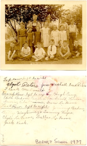
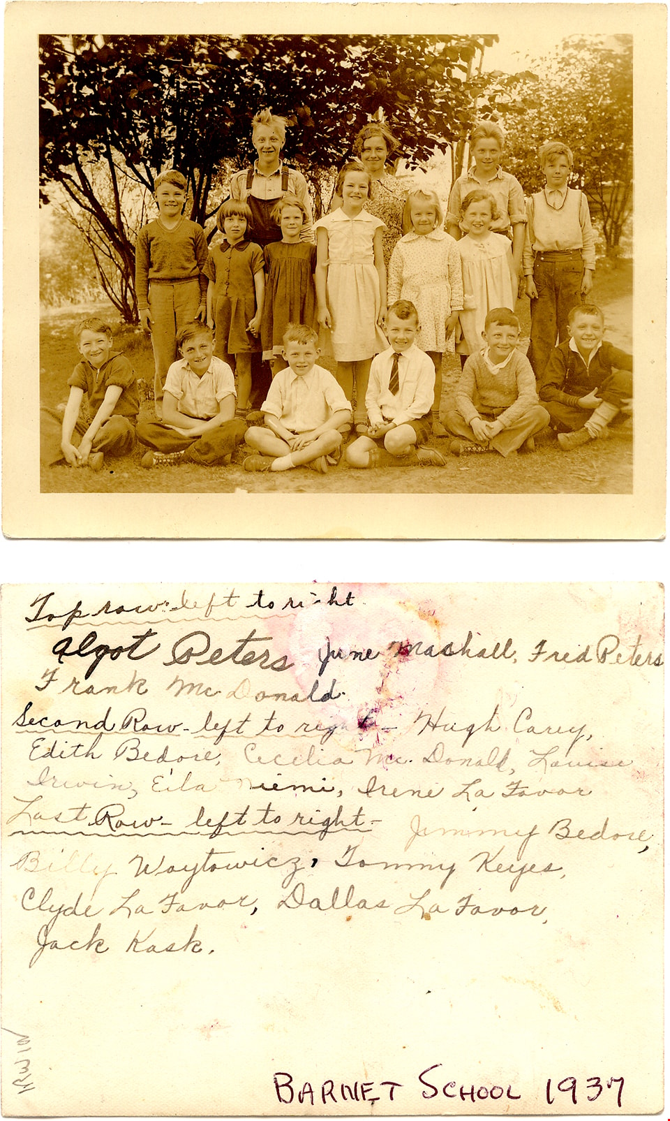
Barnet School class
https://search.heritageburnaby.ca/link/museumdescription15225
- Repository
- Burnaby Village Museum
- Date
- 1937 (date of original), copied 2004
- Collection/Fonds
- In the Shadow by the Sea collection
- Description Level
- Item
- Physical Description
- 1 photograph (tiff) : 300 dpi
- Scope and Content
- Photograph students at Barnet School. Students are gathered together on the school grounds and are identified from left to right; back row: Algot Peters, June Marshall, Fred Peters and Frank McDonald; middle row: Hugh Carey, Edith Bedore, Cecilia McDonald, Louise Irwin, Ella Neimi, Irene La Favor;…
- Repository
- Burnaby Village Museum
- Collection/Fonds
- In the Shadow by the Sea collection
- Description Level
- Item
- Physical Description
- 1 photograph (tiff) : 300 dpi
- Scope and Content
- Photograph students at Barnet School. Students are gathered together on the school grounds and are identified from left to right; back row: Algot Peters, June Marshall, Fred Peters and Frank McDonald; middle row: Hugh Carey, Edith Bedore, Cecilia McDonald, Louise Irwin, Ella Neimi, Irene La Favor; front row: Jimmy Bedore, Billy Woytowicz, Tommy Keys, Clyde La Favor, Dallas La Favor and Jack Kask.
- Names
- Barnet School
- Peters, Algot
- Marshall, June
- Peters, Fred
- McDonald, Frank
- Carey, Hugh
- Bedore, Edith
- McDonald, Cecilia
- Irwin, Louise
- Neimi, Ella
- La Favor, Louise
- Bedore, Jimmy
- Woytowicz, Billy
- Keys, Thomas "Tommy"
- La Favor, Clyde
- La Favor, Dallas
- Kask, John "Jack"
- Geographic Access
- Burrard Inlet
- Accession Code
- BV019.32.45
- Access Restriction
- No restrictions
- Reproduction Restriction
- No known restrictions
- Date
- 1937 (date of original), copied 2004
- Media Type
- Photograph
- Historic Neighbourhood
- Barnet (Historic Neighbourhood)
- Planning Study Area
- Burnaby Mountain Area
- Notes
- Title based on contents of photograph
- Names of students taken from verso of photograph
- see page 234, Chapter Three in the book "In the Shadow by the Sea - Recollections of Burnaby's Barnet Village". Caption with photograph reads: "Barnet School / Class 1936-1937 / BACK ROW: Algot Peters, June / Marshall, Fred Peters: Frank / McDonald"
Images
![Barnet School class, [between 1931 and 1932] (date of original), copied 2004 thumbnail](/media/hpo/_Data/_BVM_Images/2019/2019_0032_0048_001.jpg?width=280)
Barnet School class
https://search.heritageburnaby.ca/link/museumdescription15228
- Repository
- Burnaby Village Museum
- Date
- [between 1931 and 1932] (date of original), copied 2004
- Collection/Fonds
- In the Shadow by the Sea collection
- Description Level
- Item
- Physical Description
- 1 photograph (tiff) : 300 dpi
- Scope and Content
- Photograph students at Barnet School. Students are gathered together on wooden bleechers on the school grounds and are identified from left to right; back row: Jack Hood; Fred Proteau, Bob Johnston, John Stelioff, Billy Warner and Neil Carey; third row from bottom: Lloyd Lendgren, Joan Rutherford,…
- Repository
- Burnaby Village Museum
- Collection/Fonds
- In the Shadow by the Sea collection
- Description Level
- Item
- Physical Description
- 1 photograph (tiff) : 300 dpi
- Scope and Content
- Photograph students at Barnet School. Students are gathered together on wooden bleechers on the school grounds and are identified from left to right; back row: Jack Hood; Fred Proteau, Bob Johnston, John Stelioff, Billy Warner and Neil Carey; third row from bottom: Lloyd Lendgren, Joan Rutherford, Kathleen Cole, Patricia Longley, Annie Strelioff, Marie Galbraith and Billy Rutherford; second row from bottom: Jean Wallace, Eva Grace Hood, Kerthq's cousin, Kerthq, Maureen Johnston, Marie Swanson, Eleanor Irwin; front row at bottom: John Taranoff, John Jacobsen, Lewis La Favor, Jack Rutherford, Andrew Strelioff and Sheldon Rowell.
- Names
- Barnet School
- Yasui, Harding
- Hood, Jack
- Proteau, Frederick "Freddy"
- Stride Avenue School
- Johnston, Bob
- Strelioff, John
- Strelioff, Annie
- Warner, William "Billy"
- Carey, Neil
- Lendgren, Lloyd
- Rutherford, Joan
- Cole, Kathleen
- Longley, Patricia
- Galbraith, Marie
- Rutherford, William "Billy"
- Wallace, Jean
- Hood, Grace
- Kerthq
- Johnston, Maureen
- Swanson, Marie
- Nelson, Eleanor Irwin
- Taranoff, John
- Jacobsen, John
- La Favor, Lewis
- Rutherford, Jack S.
- Strelioff, Andrew
- Sheldon, Rowell
- Geographic Access
- Burrard Inlet
- Accession Code
- BV019.32.48
- Access Restriction
- No restrictions
- Reproduction Restriction
- No known restrictions
- Date
- [between 1931 and 1932] (date of original), copied 2004
- Media Type
- Photograph
- Historic Neighbourhood
- Barnet (Historic Neighbourhood)
- Planning Study Area
- Burnaby Mountain Area
- Notes
- Title based on contents of photograph
- Names of students taken from verso of photograph -see photograph BV019.32.47
- see page 234, Chapter Three in the book "In the Shadow by the Sea - Recollections of Burnaby's Barnet Village". Caption with photograph reads: "Barnet School / Class 1931-1932 / BACK ROW: Harding Yasui, Jack Hood, Fred Proteau, Bob Johnston, John Strelioff, Billy Warner, Neil Carey / THIRD ROW: ..."
Images
![Barnet School class, [between 1931 and 1932] (date of original), copied 2004 thumbnail](/media/hpo/_Data/_BVM_Images/2019/2019_0032_0048_001.jpg)
![Barnet School Class, [1930 or 1931] thumbnail](/media/hpo/_Data/_Archives_Images/_Unrestricted/001/016-001.jpg?width=280)
Barnet School Class
https://search.heritageburnaby.ca/link/archivedescription34290
- Repository
- City of Burnaby Archives
- Date
- [1930 or 1931]
- Collection/Fonds
- Burnaby Historical Society fonds
- Description Level
- Item
- Physical Description
- 1 photograph : sepia ; 12.5 x 17.6 cm
- Scope and Content
- Photograph of a Barnet School teacher and her class sitting and standing in rows outside the school. Annotation on back of photograph reads, "Barnet School, Barnet BC, 1928", however later information suggests that it is more likely 1930 or 1931.
- Repository
- City of Burnaby Archives
- Date
- [1930 or 1931]
- Collection/Fonds
- Burnaby Historical Society fonds
- Subseries
- Photographs subseries
- Physical Description
- 1 photograph : sepia ; 12.5 x 17.6 cm
- Description Level
- Item
- Record No.
- 016-001
- Access Restriction
- No restrictions
- Reproduction Restriction
- No known restrictions
- Accession Number
- BHS2007-04
- Scope and Content
- Photograph of a Barnet School teacher and her class sitting and standing in rows outside the school. Annotation on back of photograph reads, "Barnet School, Barnet BC, 1928", however later information suggests that it is more likely 1930 or 1931.
- Subjects
- Occupations - Teachers
- Media Type
- Photograph
- Geographic Access
- Barnet Road
- Barnet Village
- Street Address
- 7820 Barnet Road
- Historic Neighbourhood
- Barnet (Historic Neighbourhood)
- Planning Study Area
- Burnaby Mountain Area
Images
![Barnet School Class, [1930 or 1931] thumbnail](/media/hpo/_Data/_Archives_Images/_Unrestricted/001/016-001.jpg)
![Bobby and Maureen Johnston and Eleanor and Louise Irwin in swimsuits, [1933] (date of original), copied 2004 thumbnail](/media/hpo/_Data/_BVM_Images/2019/2019_0032_0101_001.jpg?width=280)
Bobby and Maureen Johnston and Eleanor and Louise Irwin in swimsuits
https://search.heritageburnaby.ca/link/museumdescription15284
- Repository
- Burnaby Village Museum
- Date
- [1933] (date of original), copied 2004
- Collection/Fonds
- In the Shadow by the Sea collection
- Description Level
- Item
- Physical Description
- 1 photograph (tiff) : 300 dpi
- Scope and Content
- Photograph of (left to right) Bobby Johnston, Eleanor Irwin (Nelson), Maureen Johnston and Louise Irwin wearing swimsuits and standing in the yard of the Irwin family home on the site of the Barnet Lumber Mill.
- Repository
- Burnaby Village Museum
- Collection/Fonds
- In the Shadow by the Sea collection
- Description Level
- Item
- Physical Description
- 1 photograph (tiff) : 300 dpi
- Scope and Content
- Photograph of (left to right) Bobby Johnston, Eleanor Irwin (Nelson), Maureen Johnston and Louise Irwin wearing swimsuits and standing in the yard of the Irwin family home on the site of the Barnet Lumber Mill.
- Names
- Barnet Mill
- Barnet Lumber Company
- Irwin, Louise
- Irwin, Elsie May Taylor
- Johnston, Bob
- Johnston, Maureen
- Geographic Access
- Burrard Inlet
- Accession Code
- BV019.32.101
- Access Restriction
- No restrictions
- Reproduction Restriction
- No known restrictions
- Date
- [1933] (date of original), copied 2004
- Media Type
- Photograph
- Historic Neighbourhood
- Barnet (Historic Neighbourhood)
- Planning Study Area
- Burnaby Mountain Area
- Notes
- Title based on contents of photograph
- See page 42 of book "In the Shadow by the Sea: Recollection of Burnaby's Barnet Village" with caption "Bobby Johnston, Eleanor Irwin, Maureen Johnston, Louise Irwin pose in their swimsuits, c. 1928"
- Date for description of photograph based on information provided in Johnston family image 8
Images
![Bobby and Maureen Johnston and Eleanor and Louise Irwin in swimsuits, [1933] (date of original), copied 2004 thumbnail](/media/hpo/_Data/_BVM_Images/2019/2019_0032_0101_001.jpg)
![Bob Crafter, [193-] (date of original), copied 1991 thumbnail](/media/hpo/_Data/_Archives_Images/_Unrestricted/370/370-007.jpg?width=280)
Bob Crafter
https://search.heritageburnaby.ca/link/archivedescription37419
- Repository
- City of Burnaby Archives
- Date
- [193-] (date of original), copied 1991
- Collection/Fonds
- Burnaby Historical Society fonds
- Description Level
- Item
- Physical Description
- 1 photograph : b&w ; 4.9 x 2.8 cm print on contact sheet 20.2 x 25.4 cm
- Scope and Content
- Photograph of Kask General Store with four people standing in front. Left to right: Australian Bob Crafter and three unidentified young people.
- Repository
- City of Burnaby Archives
- Date
- [193-] (date of original), copied 1991
- Collection/Fonds
- Burnaby Historical Society fonds
- Subseries
- Burnaby Image Bank subseries
- Physical Description
- 1 photograph : b&w ; 4.9 x 2.8 cm print on contact sheet 20.2 x 25.4 cm
- Description Level
- Item
- Record No.
- 370-007
- Access Restriction
- No restrictions
- Reproduction Restriction
- No known restrictions
- Accession Number
- BHS1999-03
- Scope and Content
- Photograph of Kask General Store with four people standing in front. Left to right: Australian Bob Crafter and three unidentified young people.
- Media Type
- Photograph
- Notes
- Title based on contents of photograph
- 1 b&w copy negative accompanying
- Geographic Access
- Barnet Road
- Street Address
- 7501 Barnet Road
- Historic Neighbourhood
- Barnet (Historic Neighbourhood)
- Planning Study Area
- Burnaby Mountain Area
Images
![Bob Crafter, [193-] (date of original), copied 1991 thumbnail](/media/hpo/_Data/_Archives_Images/_Unrestricted/370/370-007.jpg)
![Bob Crafter and Bill Kask, Sr., [193-] (date of original), copied 1991 thumbnail](/media/hpo/_Data/_Archives_Images/_Unrestricted/370/370-008.jpg?width=280)
Bob Crafter and Bill Kask, Sr.
https://search.heritageburnaby.ca/link/archivedescription37420
- Repository
- City of Burnaby Archives
- Date
- [193-] (date of original), copied 1991
- Collection/Fonds
- Burnaby Historical Society fonds
- Description Level
- Item
- Physical Description
- 1 photograph : b&w ; 4.9 x 2.8 cm print on contact sheet 20.2 x 25.4 cm
- Scope and Content
- Photograph of (left to right) Australian Bob Crafter and William "Bill" Kask, Sr., standing in front of Kask General Store.
- Repository
- City of Burnaby Archives
- Date
- [193-] (date of original), copied 1991
- Collection/Fonds
- Burnaby Historical Society fonds
- Subseries
- Burnaby Image Bank subseries
- Physical Description
- 1 photograph : b&w ; 4.9 x 2.8 cm print on contact sheet 20.2 x 25.4 cm
- Description Level
- Item
- Record No.
- 370-008
- Access Restriction
- No restrictions
- Reproduction Restriction
- No known restrictions
- Accession Number
- BHS1999-03
- Scope and Content
- Photograph of (left to right) Australian Bob Crafter and William "Bill" Kask, Sr., standing in front of Kask General Store.
- Subjects
- Occupations - Entrepreneurs
- Media Type
- Photograph
- Notes
- Title based on contents of photograph
- 1 b&w copy negative accompanying
- Geographic Access
- Barnet Road
- Street Address
- 7501 Barnet Road
- Historic Neighbourhood
- Barnet (Historic Neighbourhood)
- Planning Study Area
- Burnaby Mountain Area
Images
![Bob Crafter and Bill Kask, Sr., [193-] (date of original), copied 1991 thumbnail](/media/hpo/_Data/_Archives_Images/_Unrestricted/370/370-008.jpg)