Narrow Results By
Subject
- Advertising Medium - Signs and Signboards 5
- Animals - Birds 2
- Animals - Cats 3
- Animals - Dogs 13
- Animals - Horses 2
- Animals - Poultry 1
- Buildings 1
- Buildings - Agricultural 3
- Buildings - Agricultural - Greenhouses 5
- Buildings - Agricultural - Nurseries 2
- Buildings - Civic 1
- Buildings - Civic - Fire Halls 1

Central Park Neighbourhood
https://search.heritageburnaby.ca/link/landmark688
- Repository
- Burnaby Heritage Planning
- Associated Dates
- 1925-1954
- Heritage Value
- Although still largely a rural area during the 1920s, subdivisions began appearing in the Central Park neighbourhood at this time. Development was slowed by the Great Depression of the 1930s but the influx of commercial buildings and new housing initiatives in the post-war boom led to a period of rapid growth especially in the Garden Village subdivision which was undertaken in 1953 with the plan to build 500 modern homes in the 140-acre site. Despite the closure of the interurban line in 1953, the neighbourhood remained an active commercial and residential centre.
- Historic Neighbourhood
- Central Park (Historic Neighbourhood)
- Planning Study Area
- Maywood Area
Images

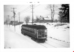
B.C. Electric Railway tram no. 1306 on Central Park Line
https://search.heritageburnaby.ca/link/museumdescription2902
- Repository
- Burnaby Village Museum
- Date
- 1952
- Collection/Fonds
- Burnaby Village Museum Photograph collection
- Description Level
- Item
- Physical Description
- 1 photograph : b&w ; 9 x 13 cm
- Scope and Content
- Phototgraph of B.C. Electric Railway tram no. 1306 running on the tracks between Earles Road and Collingwood west on the Central Park Line. The ground is covered with snow.
- Repository
- Burnaby Village Museum
- Collection/Fonds
- Burnaby Village Museum Photograph collection
- Description Level
- Item
- Physical Description
- 1 photograph : b&w ; 9 x 13 cm
- Scope and Content
- Phototgraph of B.C. Electric Railway tram no. 1306 running on the tracks between Earles Road and Collingwood west on the Central Park Line. The ground is covered with snow.
- Accession Code
- BV012.36.10
- Access Restriction
- No restrictions
- Reproduction Restriction
- No known restrictions
- Date
- 1952
- Media Type
- Photograph
- Scan Resolution
- 600
- Scan Date
- 2022-07-26
- Notes
- Title based on contents of photograph
- "Khulman built BCER #1306 / running between Earles Road and Collingwood / west on Central Park Line 1952 / Earles Road substation in background"
Images

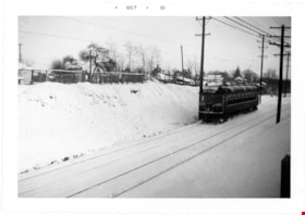
B.C. Electric Railway tram no. 1309 tram on Central Park Line
https://search.heritageburnaby.ca/link/museumdescription2896
- Repository
- Burnaby Village Museum
- Date
- 1953
- Collection/Fonds
- Burnaby Village Museum Photograph collection
- Description Level
- Item
- Physical Description
- 1 photograph : b&w ; 9 x 13 cm
- Scope and Content
- Photograph of B.C. Electric Railway tram no. 1309 travelling along the Central Park Line westbound to Vancouver between Collingwood West and Earls Road after a winter storm. The tracks and hillside are covered with snow.
- Repository
- Burnaby Village Museum
- Collection/Fonds
- Burnaby Village Museum Photograph collection
- Description Level
- Item
- Physical Description
- 1 photograph : b&w ; 9 x 13 cm
- Scope and Content
- Photograph of B.C. Electric Railway tram no. 1309 travelling along the Central Park Line westbound to Vancouver between Collingwood West and Earls Road after a winter storm. The tracks and hillside are covered with snow.
- Accession Code
- BV012.36.4
- Access Restriction
- No restrictions
- Reproduction Restriction
- No known restrictions
- Date
- 1953
- Media Type
- Photograph
- Scan Resolution
- 600
- Scan Date
- 2022-07-26
- Notes
- Title based on contents of photograph
- Typewritten text on verso of photograph reads: "Home built B.C.E.R. #1309 hurries along / Central Park line westbound to Vancovuer / between Collingwood West and Earls Road / after a winter snow storm in 1953"
Images

![Burnaby Schools Day at Central Park, [between 1937 and 1940] (date of original), copied 1986 thumbnail](/media/hpo/_Data/_Archives_Images/_Unrestricted/126/190-004.jpg?width=280)
Burnaby Schools Day at Central Park
https://search.heritageburnaby.ca/link/archivedescription35084
- Repository
- City of Burnaby Archives
- Date
- [between 1937 and 1940] (date of original), copied 1986
- Collection/Fonds
- Burnaby Historical Society fonds
- Description Level
- Item
- Physical Description
- 1 photograph : b&w ; 8.8 x 12.5 cm print
- Scope and Content
- Photograph of Burnaby Schools Day held at Central Park. Children are dancing on a field. A water tower can be seen in the distance.
- Repository
- City of Burnaby Archives
- Date
- [between 1937 and 1940] (date of original), copied 1986
- Collection/Fonds
- Burnaby Historical Society fonds
- Subseries
- Davies family subseries
- Physical Description
- 1 photograph : b&w ; 8.8 x 12.5 cm print
- Description Level
- Item
- Record No.
- 190-004
- Access Restriction
- No restrictions
- Reproduction Restriction
- No known restrictions
- Accession Number
- BHS1986-41
- Scope and Content
- Photograph of Burnaby Schools Day held at Central Park. Children are dancing on a field. A water tower can be seen in the distance.
- Media Type
- Photograph
- Notes
- Title based on contents of photograph
- Geographic Access
- Central Park
- Imperial Street
- Street Address
- 3883 Imperial Street
- Historic Neighbourhood
- Central Park (Historic Neighbourhood)
- Planning Study Area
- Maywood Area
Images
![Burnaby Schools Day at Central Park, [between 1937 and 1940] (date of original), copied 1986 thumbnail](/media/hpo/_Data/_Archives_Images/_Unrestricted/126/190-004.jpg)
![Central Park, [195-] (date of original), copied 1986 thumbnail](/media/hpo/_Data/_Archives_Images/_Unrestricted/126/190-009.jpg?width=280)
Central Park
https://search.heritageburnaby.ca/link/archivedescription35089
- Repository
- City of Burnaby Archives
- Date
- [195-] (date of original), copied 1986
- Collection/Fonds
- Burnaby Historical Society fonds
- Description Level
- Item
- Physical Description
- 1 photograph : b&w ; 8.8 x 12.4 cm print
- Scope and Content
- Photograph of a boys baseball team at Central Park. A grandstand can be seen behind them.
- Repository
- City of Burnaby Archives
- Date
- [195-] (date of original), copied 1986
- Collection/Fonds
- Burnaby Historical Society fonds
- Subseries
- Davies family subseries
- Physical Description
- 1 photograph : b&w ; 8.8 x 12.4 cm print
- Description Level
- Item
- Record No.
- 190-009
- Access Restriction
- No restrictions
- Reproduction Restriction
- Reproduce for fair dealing purposes only
- Accession Number
- BHS1986-41
- Scope and Content
- Photograph of a boys baseball team at Central Park. A grandstand can be seen behind them.
- Media Type
- Photograph
- Notes
- Title based on contents of photograph
- Geographic Access
- Central Park
- Imperial Street
- Street Address
- 3883 Imperial Street
Images
![Central Park, [195-] (date of original), copied 1986 thumbnail](/media/hpo/_Data/_Archives_Images/_Unrestricted/126/190-009.jpg)
![Central Park Garage Opening, [1955] thumbnail](/media/Hpo/_Data/_Archives_Images/_Unrestricted/485/486-008.jpg?width=280)
Central Park Garage Opening
https://search.heritageburnaby.ca/link/archivedescription55614
- Repository
- City of Burnaby Archives
- Date
- [1955]
- Collection/Fonds
- Charles MacSorley fonds
- Description Level
- Item
- Physical Description
- 1 photograph : b&w ; 20.5 x 25.5 cm
- Scope and Content
- Photograph of four men on stage in front of a microphone at what is identified by the caption as the "Central Park Garage Opening." Charles MacSorley is standing to the right, but the others are unknown.
- Repository
- City of Burnaby Archives
- Date
- [1955]
- Collection/Fonds
- Charles MacSorley fonds
- Physical Description
- 1 photograph : b&w ; 20.5 x 25.5 cm
- Description Level
- Item
- Record No.
- 486-008
- Access Restriction
- No restrictions
- Reproduction Restriction
- Reproduce for fair dealing purposes only
- Accession Number
- 2005-14
- Scope and Content
- Photograph of four men on stage in front of a microphone at what is identified by the caption as the "Central Park Garage Opening." Charles MacSorley is standing to the right, but the others are unknown.
- Subjects
- Events - Openings
- Persons - Crowds
- Officials - Mayors and Reeves
- Sound Communication Tools and Equipment - Microphones
- Names
- MacSorley, Charles W.
- Media Type
- Photograph
- Photographer
- Allan Studios
- Notes
- Title based on caption
- Photographer's stamp on verso
- Geographic Access
- Central Park
- Imperial Street
- Street Address
- 3883 Imperial Street
- Historic Neighbourhood
- Central Park (Historic Neighbourhood)
- Planning Study Area
- Maywood Area
Images
![Central Park Garage Opening, [1955] thumbnail](/media/Hpo/_Data/_Archives_Images/_Unrestricted/485/486-008.jpg)
![Central Park Garage Opening, [1955] thumbnail](/media/Hpo/_Data/_Archives_Images/_Unrestricted/485/486-009.jpg?width=280)
Central Park Garage Opening
https://search.heritageburnaby.ca/link/archivedescription55615
- Repository
- City of Burnaby Archives
- Date
- [1955]
- Collection/Fonds
- Charles MacSorley fonds
- Description Level
- Item
- Physical Description
- 1 photograph : b&w ; 20.5 x 25.5 cm
- Scope and Content
- Photograph of six men standing or seated around a table at what is identified by the caption as the "Central Park Garage Opening." Charles MacSorley is standing second from the right, the others are unknown.
- Repository
- City of Burnaby Archives
- Date
- [1955]
- Collection/Fonds
- Charles MacSorley fonds
- Physical Description
- 1 photograph : b&w ; 20.5 x 25.5 cm
- Description Level
- Item
- Record No.
- 486-009
- Access Restriction
- No restrictions
- Reproduction Restriction
- Reproduce for fair dealing purposes only
- Accession Number
- 2005-14
- Scope and Content
- Photograph of six men standing or seated around a table at what is identified by the caption as the "Central Park Garage Opening." Charles MacSorley is standing second from the right, the others are unknown.
- Names
- MacSorley, Charles W.
- Media Type
- Photograph
- Photographer
- Allan Studios
- Notes
- Title based on caption
- Photographer's stamp on verso
- Geographic Access
- Central Park
- Imperial Street
- Street Address
- 3883 Imperial Street
- Historic Neighbourhood
- Central Park (Historic Neighbourhood)
- Planning Study Area
- Maywood Area
Images
![Central Park Garage Opening, [1955] thumbnail](/media/Hpo/_Data/_Archives_Images/_Unrestricted/485/486-009.jpg)
![Central Park Interurban trams, [1930] (date of original), copied 1986 thumbnail](/media/hpo/_Data/_Archives_Images/_Unrestricted/204/204-370.jpg?width=280)
Central Park Interurban trams
https://search.heritageburnaby.ca/link/archivedescription35512
- Repository
- City of Burnaby Archives
- Date
- [1930] (date of original), copied 1986
- Collection/Fonds
- Burnaby Historical Society fonds
- Description Level
- Item
- Physical Description
- 1 photograph : b&w ; 12.7 x 17.8 cm print
- Scope and Content
- Photograph of Central Park Interurban trams at Royal Oak Station. Jimmy Strachan, the motorman, is not visible.
- Repository
- City of Burnaby Archives
- Date
- [1930] (date of original), copied 1986
- Collection/Fonds
- Burnaby Historical Society fonds
- Subseries
- Pioneer Tales subseries
- Physical Description
- 1 photograph : b&w ; 12.7 x 17.8 cm print
- Description Level
- Item
- Record No.
- 204-370
- Access Restriction
- No restrictions
- Reproduction Restriction
- No known restrictions
- Accession Number
- BHS1988-03
- Scope and Content
- Photograph of Central Park Interurban trams at Royal Oak Station. Jimmy Strachan, the motorman, is not visible.
- Media Type
- Photograph
- Notes
- Title based on contents of photograph
- Geographic Access
- Central Park Interurban line
- Historic Neighbourhood
- Central Park (Historic Neighbourhood)
- Planning Study Area
- Windsor Area
Images
![Central Park Interurban trams, [1930] (date of original), copied 1986 thumbnail](/media/hpo/_Data/_Archives_Images/_Unrestricted/204/204-370.jpg)
![Charles MacSorley at the Central Park Garage Opening, [1955] thumbnail](/media/Hpo/_Data/_Archives_Images/_Unrestricted/485/486-010.jpg?width=280)
Charles MacSorley at the Central Park Garage Opening
https://search.heritageburnaby.ca/link/archivedescription55616
- Repository
- City of Burnaby Archives
- Date
- [1955]
- Collection/Fonds
- Charles MacSorley fonds
- Description Level
- Item
- Physical Description
- 1 photograph : b&w ; 20.5 x 25.5 cm
- Scope and Content
- Photograph of Reeve Charles MacSorley reaching into a large ballot drum to draw a ticket in front of a crowd gathered at Burnaby's Central Park. Two men are standing on the stage with him; one is in a suit, the other is in a uniform.
- Repository
- City of Burnaby Archives
- Date
- [1955]
- Collection/Fonds
- Charles MacSorley fonds
- Physical Description
- 1 photograph : b&w ; 20.5 x 25.5 cm
- Description Level
- Item
- Record No.
- 486-010
- Access Restriction
- No restrictions
- Reproduction Restriction
- Reproduce for fair dealing purposes only
- Accession Number
- 2005-14
- Scope and Content
- Photograph of Reeve Charles MacSorley reaching into a large ballot drum to draw a ticket in front of a crowd gathered at Burnaby's Central Park. Two men are standing on the stage with him; one is in a suit, the other is in a uniform.
- Names
- MacSorley, Charles W.
- Media Type
- Photograph
- Photographer
- Allan Studios
- Notes
- Title based on contents of photograph
- Photographer's stamp on verso
- Note on verso reads: "Station opening file"
- Geographic Access
- Central Park
- Imperial Street
- Street Address
- 3883 Imperial Street
- Historic Neighbourhood
- Central Park (Historic Neighbourhood)
- Planning Study Area
- Maywood Area
Images
![Charles MacSorley at the Central Park Garage Opening, [1955] thumbnail](/media/Hpo/_Data/_Archives_Images/_Unrestricted/485/486-010.jpg)
Dedication of flag at Central Park
https://search.heritageburnaby.ca/link/museumdescription4892
- Repository
- Burnaby Village Museum
- Date
- May 6, 1935
- Collection/Fonds
- Burnaby Girl Guides fonds
- Description Level
- Item
- Physical Description
- 1 photograph : sepia ;12 x 17.5 cm
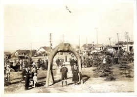
- Scope and Content
- Photograph identified as "Dedication of the flag at Central Park" at the May Day celebration "May 6th, 1935". An unidentified Boy Scout and Girl Guide leader dressed in uniforms stand at the centre of the photograph under a large log arch while a small group of people look on and a large group of…
- Repository
- Burnaby Village Museum
- Collection/Fonds
- Burnaby Girl Guides fonds
- Description Level
- Item
- Physical Description
- 1 photograph : sepia ;12 x 17.5 cm
- Scope and Content
- Photograph identified as "Dedication of the flag at Central Park" at the May Day celebration "May 6th, 1935". An unidentified Boy Scout and Girl Guide leader dressed in uniforms stand at the centre of the photograph under a large log arch while a small group of people look on and a large group of Girl Guides in uniforms are gathered in a line in the background.
- Geographic Access
- Central Park
- Accession Code
- BV015.35.250
- Access Restriction
- No restrictions
- Reproduction Restriction
- No known restrictions
- Date
- May 6, 1935
- Media Type
- Photograph
- Historic Neighbourhood
- Central Park (Historic Neighbourhood)
- Planning Study Area
- Maywood Area
- Scan Resolution
- 600
- Scan Date
- January 5, 2021
- Scale
- 100
- Notes
- Title based on caption of photograph
- Note in black ink on scrapbook page reads: "May 6th 1935 / Dedication of flag at Central Park"
- Annotation at bottom of photograph reads, "May Day Celebration / Burnaby, BC, May 6, 1935 / Stride Studios Photos"
- Note in pencil on verso of photograph reads: "May 6 1935 / Dedicating of flag at Central Pk."
- Photograph is a part of page 37 of scrapbook "Burnaby Girl Guides. -- [1914]-1969, predominant ca. 1920" (BV.015.35.164)
Images

Dedication of flag at Central Park
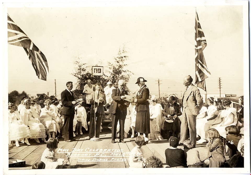
https://search.heritageburnaby.ca/link/museumdescription4893
- Repository
- Burnaby Village Museum
- Date
- May 6, 1935
- Collection/Fonds
- Burnaby Girl Guides fonds
- Description Level
- Item
- Physical Description
- 1 photograph : sepia ;12 x 17.5 cm
- Scope and Content
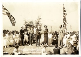
- Photograph identified as the dedication of the flag at the May Day celebration at Central Park, May 6th, 1935. An unidentified Girl Guide leader is standing near the centre of a stage and presented with a certificate or award by former Burnaby Reeve Thomas F. Sanderson. There is an unidentifed ma…
- Repository
- Burnaby Village Museum
- Collection/Fonds
- Burnaby Girl Guides fonds
- Description Level
- Item
- Physical Description
- 1 photograph : sepia ;12 x 17.5 cm
- Scope and Content
- Photograph identified as the dedication of the flag at the May Day celebration at Central Park, May 6th, 1935. An unidentified Girl Guide leader is standing near the centre of a stage and presented with a certificate or award by former Burnaby Reeve Thomas F. Sanderson. There is an unidentifed man standing at a microphone in the centre of the stage surrounded by onlookers and the May Queen and her suite.
- Geographic Access
- Central Park
- Accession Code
- BV015.35.251
- Access Restriction
- No restrictions
- Reproduction Restriction
- No known restrictions
- Date
- May 6, 1935
- Media Type
- Photograph
- Historic Neighbourhood
- Central Park (Historic Neighbourhood)
- Planning Study Area
- Maywood Area
- Scan Resolution
- 600
- Scan Date
- January 5, 2021
- Scale
- 100
- Notes
- Title based on caption of photograph
- Note in black ink on scrapbook page reads: "May 6th 1935 / Dedication of flag at Central Park"
- Annotation at bottom of photograph reads, "May Day Celebration / Burnaby, BC, May 6, 1935 / Stride Studios Photos"
- Note in pencil on verso of photograph reads: "May 6 1935 / Dedicating of flag at Central Pk."
- Photograph is a part of page 37 of scrapbook "Burnaby Girl Guides. -- [1914]-1969, predominant ca. 1920" (BV.015.35.164)
Images
![Drawing a ticket at Central Park garage opening, [1955] thumbnail](/media/Hpo/_Data/_Archives_Images/_Unrestricted/485/486-007.jpg?width=280)
Drawing a ticket at Central Park garage opening
https://search.heritageburnaby.ca/link/archivedescription55613
- Repository
- City of Burnaby Archives
- Date
- [1955]
- Collection/Fonds
- Charles MacSorley fonds
- Description Level
- Item
- Physical Description
- 1 photograph : b&w ; 20.5 x 25.5 cm
- Scope and Content
- Photograph of Reeve Charles MacSorley reaching into a large ballot drum to draw a ticket in front of a crowd gathered at Burnaby's Central Park. An unidentified man stands beside him, smiling at the crowd. A caption written on the bottom of the photograph reads: "Drawing a tickett [sic] at Central…
- Repository
- City of Burnaby Archives
- Date
- [1955]
- Collection/Fonds
- Charles MacSorley fonds
- Physical Description
- 1 photograph : b&w ; 20.5 x 25.5 cm
- Description Level
- Item
- Record No.
- 486-007
- Access Restriction
- No restrictions
- Reproduction Restriction
- Reproduce for fair dealing purposes only
- Accession Number
- 2005-14
- Scope and Content
- Photograph of Reeve Charles MacSorley reaching into a large ballot drum to draw a ticket in front of a crowd gathered at Burnaby's Central Park. An unidentified man stands beside him, smiling at the crowd. A caption written on the bottom of the photograph reads: "Drawing a tickett [sic] at Central Park garage opening."
- Names
- MacSorley, Charles W.
- Media Type
- Photograph
- Photographer
- Allan Studios
- Notes
- Transcribed title
- Title based on caption
- Photographer's stamp on verso
- Geographic Access
- Central Park
- Imperial Street
- Street Address
- 3883 Imperial Street
- Historic Neighbourhood
- Central Park (Historic Neighbourhood)
- Planning Study Area
- Maywood Area
Images
![Drawing a ticket at Central Park garage opening, [1955] thumbnail](/media/Hpo/_Data/_Archives_Images/_Unrestricted/485/486-007.jpg)

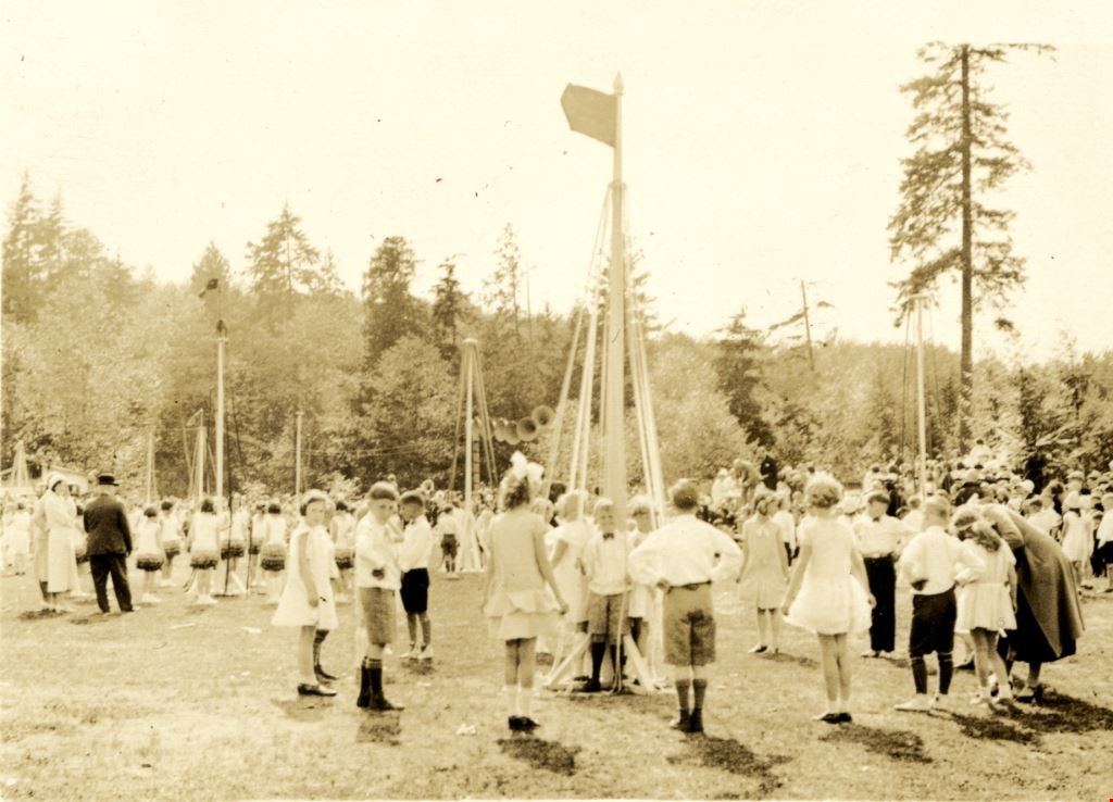
May Day at Central Park
https://search.heritageburnaby.ca/link/archivedescription86559
- Repository
- City of Burnaby Archives
- Date
- 1932
- Collection/Fonds
- Richard Hardy family fonds
- Description Level
- Item
- Physical Description
- 1 photograph : sepia ; 6 x 8.5 cm
- Scope and Content
- Photograph of children dancing around a may pole during the Burnaby May Day celebrations at Central Park.
- Repository
- City of Burnaby Archives
- Date
- 1932
- Collection/Fonds
- Richard Hardy family fonds
- Physical Description
- 1 photograph : sepia ; 6 x 8.5 cm
- Description Level
- Item
- Record No.
- 570-015
- Access Restriction
- No restrictions
- Reproduction Restriction
- No known restrictions
- Accession Number
- 2014-16
- Scope and Content
- Photograph of children dancing around a may pole during the Burnaby May Day celebrations at Central Park.
- Subjects
- Events - May Day
- Media Type
- Photograph
- Notes
- Title based on contents of photograph
- Note on verso reads: "Bby May Day / 1932 / Cent. Park?"
- Geographic Access
- Central Park
- Historic Neighbourhood
- Central Park (Historic Neighbourhood)
- Planning Study Area
- Maywood Area
Images

Jubilee Grove Arch
https://search.heritageburnaby.ca/link/landmark533
- Repository
- Burnaby Heritage Planning
- Description
- The Jubilee Grove Arch sits at the corner of Kingsway and Patterson Avenue. Located within Central Park, the ceremonial arch and its decorative plantings provide a visual anchor to the northeast corner and entry point to the park.
- Associated Dates
- 1939
- Formal Recognition
- Heritage Designation, Community Heritage Register
- Street View URL
- Google Maps Street View
- Repository
- Burnaby Heritage Planning
- Geographic Access
- Imperial Street
- Associated Dates
- 1939
- Formal Recognition
- Heritage Designation, Community Heritage Register
- Enactment Type
- Bylaw No. 9807
- Enactment Date
- 23/11/1992
- Description
- The Jubilee Grove Arch sits at the corner of Kingsway and Patterson Avenue. Located within Central Park, the ceremonial arch and its decorative plantings provide a visual anchor to the northeast corner and entry point to the park.
- Heritage Value
- Jubilee Grove Arch was dedicated as part of the municipality’s celebration of the Jubilee of the coronation of King George V and was dedicated during Burnaby’s annual May Day celebrations in 1935. Much of the construction work was carried out by local citizens under the direction of the Burnaby Engineering Department through a Depression era work relief program that provided a way for local residents to pay their taxes. The garden was also chosen as the site for the ceremonial planting of an oak tree from the Royal Forest at Windsor, in honor of the Coronation of King George VI and Queen Elizabeth in 1937. The original bronze garden dedication plaque and oak tree remain at the site today. The decorative stone arch was erected in 1939 as a symbol of Burnaby's, and the Lower Mainland of British Columbia’s, strong ties to the English monarchy at the time, and the arch’s unveiling during May Day ceremonies shows the social role that such a commemorative feature played both to the local government and people of Burnaby. It was erected just prior to the Royal Visit of 1939, the first time that reigning British monarchs had travelled to Canada. Built of Haddington Island sandstone, the arch itself was reconstructed from a salvaged architectural element of a historic Vancouver landmark. The arch originally framed the entrance door to the Vancouver Club building in Vancouver, built in 1893-94 on West Hastings Street and designed by architect C.O. Wickenden. The building was demolished in 1930, however the arch was stored and rebuilt as the focal point of the Jubilee Grove after being bought by the Municipality of Burnaby. The work was undertaken by Italian-born stone mason Rizieri Stefanini (1879-1954), the owner of Burnaby Monumental Works. The re-use of the arch symbolizes the close tie between Vancouver and Burnaby and the joint evolution of the neighbouring cities.
- Defining Elements
- The Jubilee Grove Arch has character-defining elements that recognize it both as a remnant of a past building and as a new and individual structure. These include its: - axial diagonal placement and prominent corner location marking one of the entries to Central Park - visibility and accessibility as a public monument - hand carved stone blocks of Haddington Island sandstone - decorative twisted-rope motif carved to outline the arch - supporting rusticated sidewalls with planting urns - original bronze dedication plaque - flanking ornamental gardens - Royal Oak tree and plaque
- Historic Neighbourhood
- Central Park (Historic Neighbourhood)
- Planning Study Area
- Maywood Area
- Organization
- City of Burnaby
- Architect
- C.O. Wickenden
- Function
- Primary Current--Park Fixture
- Primary Historic--Park Fixture
- Community
- Burnaby
- Cadastral Identifier
- P.I.D. No. 017-767-172 Legal Description: Block B of Lot 2 Except Firstly: Part on Plan 8669 and Secondly: Part on Plan LMP4689 District Lot 151, Group 1, New Westminster District, Plan 3443
- Boundaries
- The property (Central Park) is a municipally-owned park that lies at the western edge of Burnaby, between 49th Avenue to the south, Kingsway to the north, Boundary Road to the west and Patterson Avenue to the east.
- Area
- 853,403.82
- Contributing Resource
- Structure
- Landscape Feature
- Ownership
- Public (local)
- Documentation
- Heritage Site Files: PC77000 20. City of Burnaby Planning and Building Department, 4949 Canada Way, Burnaby, B.C., V5G 1M2
- Names
- Burnaby Monumental Works
- Street Address
- 3883 Imperial Street
- Street View URL
- Google Maps Street View
Images


Suncrest Neighbourhood
https://search.heritageburnaby.ca/link/landmark839
- Repository
- Burnaby Heritage Planning
- Associated Dates
- 1955-2008
- Heritage Value
- The Suncrest Neighbourhood is a small residential area south of Burnaby's Central Park. The Ocean View Burial Park takes up a large area of land in the north-east corner of this neighbourhood and the majority of the housing was built during the 1930-1960 period.
- Historic Neighbourhood
- Alta Vista (Historic Neighbourhood)
- Planning Study Area
- Suncrest Area
Images


Ford Motor Company
https://search.heritageburnaby.ca/link/landmark698
- Repository
- Burnaby Heritage Planning
- Geographic Access
- Kingsway
- Associated Dates
- 1938
- Heritage Value
- In 1938, the Ford Motor Company selected Burnaby as its site for a new assembly plant to serve Western Canada. Ford purchased the land which had been owned by the Silver family at Kingsway and Silver Avenue and built its factory using steel from Burnaby's Dominion Bridge Company. During World War II, the plant was used to produce military vehicles. In 1988, the building was demolished and the Station Square development was constructed on the site.
- Historic Neighbourhood
- Central Park (Historic Neighbourhood)
- Planning Study Area
- Maywood Area
- Street Address
- 4600 Kingsway
Images


Garden Village Neighbourhood
https://search.heritageburnaby.ca/link/landmark800
- Repository
- Burnaby Heritage Planning
- Associated Dates
- 1955-2008
- Heritage Value
- Bounded by Moscrop Street to the north, Kingsway and Grange to the south, Willingdon to the east and Boundary Road to the west, the Garden Village Neighbourhood is characterised as a primarily residential area that is well-served due to its proximity to commercial, park and business centres. The north-east corner of the neighbourhood is a typical 1950s subdivision of mostly single family homes located on an irregular street pattern, while the remaining areas saw some transition to multi-family housing types throughout the 1970s and up to the current time.
- Historic Neighbourhood
- Central Park (Historic Neighbourhood)
- Planning Study Area
- Garden Village Area
Images


Marlborough Elementary School
https://search.heritageburnaby.ca/link/landmark695
- Repository
- Burnaby Heritage Planning
- Geographic Access
- Marlborough Avenue
- Associated Dates
- 1950
- Heritage Value
- Marlborough Elementary School was built in 1950 and was the second elementary school to be built in Burnaby after the start of the World War Two housing boom. Its design helped establish the general plans for future schools built in the city during this period - no basements, second stories or high stairways. Classrooms could easily be added, in line, as the need arose. There were additions made to Marlborough in 1952, 1961, 1967 and 1971.
- Historic Neighbourhood
- Central Park (Historic Neighbourhood)
- Planning Study Area
- Marlborough Area
- Street Address
- 6060 Marlborough Avenue
- Street View URL
- Google Maps Street View
Images


Marlborough Neighbourhood
https://search.heritageburnaby.ca/link/landmark802
- Repository
- Burnaby Heritage Planning
- Associated Dates
- 1955-2008
- Heritage Value
- The Marlborough Neighbourhood is another residential area that was witness to rapid growth and subdivision during the 1950s and 1960s, creating primarily single-family housing stock. In the 1970s and 1980s, as the commercial district around Kingsway grew, so too did higher density housing projects such as townhomes and condominiums.
- Historic Neighbourhood
- Central Park (Historic Neighbourhood)
- Planning Study Area
- Marlborough Area
Images


Maywood Neighbourhood
https://search.heritageburnaby.ca/link/landmark801
- Repository
- Burnaby Heritage Planning
- Associated Dates
- 1955-2008
- Heritage Value
- Burnaby's Maywood Neighbourhood consists of the Metrotown Town Centre - one of four Town Centres in the City. Metrotown is one of the region's most developed and fastest growing centres. It is served by the first SkyTrain line developed in the mid-1980s and anchored by B.C.'s largest shopping and entertainment complex. As an older centre that has progressively added new developments over the years, Metrotown offers a range of housing types and tenures from three-storey walk-up apartments to modern residential towers.
- Historic Neighbourhood
- Central Park (Historic Neighbourhood)
- Planning Study Area
- Maywood Area
Images
