Narrow Results By

Abandonded farm house
https://search.heritageburnaby.ca/link/archivedescription36511
- Repository
- City of Burnaby Archives
- Date
- 1950
- Collection/Fonds
- Burnaby Historical Society fonds
- Description Level
- Item
- Physical Description
- 1 photograph : b&w ; 8.5 x 14 cm
- Scope and Content
- Photograph of an abandoned farm house on Government Road.
- Repository
- City of Burnaby Archives
- Date
- 1950
- Collection/Fonds
- Burnaby Historical Society fonds
- Subseries
- Photographs subseries
- Physical Description
- 1 photograph : b&w ; 8.5 x 14 cm
- Description Level
- Item
- Record No.
- 288-002
- Access Restriction
- No restrictions
- Reproduction Restriction
- Reproduce for fair dealing purposes only
- Accession Number
- BHS1992-23
- Scope and Content
- Photograph of an abandoned farm house on Government Road.
- Media Type
- Photograph
- Notes
- Title based on contents of photograph
- Photograph is a modern contact print of an original negative that was loaned to the Archives
- Geographic Access
- Government Road
- Historic Neighbourhood
- Lochdale (Historic Neighbourhood)
- Planning Study Area
- Government Road Area
Images

![Burnaby Lake, [193-] thumbnail](/media/hpo/_Data/_Archives_Images/_Unrestricted/001/072-001.jpg?width=280)
Burnaby Lake
https://search.heritageburnaby.ca/link/archivedescription34637
- Repository
- City of Burnaby Archives
- Date
- [193-]
- Collection/Fonds
- Burnaby Historical Society fonds
- Description Level
- Item
- Physical Description
- 1 photograph : b&w ; 12.7 x 20.3 cm
- Scope and Content
- Aerial photograph of Burnaby Lake and North Burnaby.
- Repository
- City of Burnaby Archives
- Date
- [193-]
- Collection/Fonds
- Burnaby Historical Society fonds
- Subseries
- Photographs subseries
- Physical Description
- 1 photograph : b&w ; 12.7 x 20.3 cm
- Description Level
- Item
- Record No.
- 072-001
- Access Restriction
- No restrictions
- Reproduction Restriction
- No known restrictions
- Accession Number
- BHS2007-04
- Scope and Content
- Aerial photograph of Burnaby Lake and North Burnaby.
- Media Type
- Photograph
- Notes
- Title based on contents of photograph
- Geographic Access
- Burnaby Lake
- Historic Neighbourhood
- Burnaby Lake (Historic Neighbourhood)
- Lozells (Historic Neighbourhood)
- Lochdale (Historic Neighbourhood)
- Planning Study Area
- Parkcrest-Aubrey Area
- Ardingley-Sprott Area
- Burnaby Lake Area
- Government Road Area
- Sperling-Broadway Area
- Lochdale Area
Images
![Burnaby Lake, [193-] thumbnail](/media/hpo/_Data/_Archives_Images/_Unrestricted/001/072-001.jpg)
![Butler House at 8006 Government Road, [193-] thumbnail](/media/hpo/_Data/_BVM_Images/1983/198300420001.jpg?width=280)
Butler House at 8006 Government Road
https://search.heritageburnaby.ca/link/museumdescription281
- Repository
- Burnaby Village Museum
- Date
- [193-]
- Collection/Fonds
- Burnaby Village Museum Photograph collection
- Description Level
- Item
- Physical Description
- 1 photograph : b&w ; 6.1 x 8.6 cm
- Scope and Content
- Photograph of a house with wood plank boardwalk leading to the front door. On both sides of the planks are flower beds. The house is located at 8006 Government Road, Burnaby. Another house can be seen to the left of the photograph.
- Repository
- Burnaby Village Museum
- Collection/Fonds
- Burnaby Village Museum Photograph collection
- Description Level
- Item
- Physical Description
- 1 photograph : b&w ; 6.1 x 8.6 cm
- Scope and Content
- Photograph of a house with wood plank boardwalk leading to the front door. On both sides of the planks are flower beds. The house is located at 8006 Government Road, Burnaby. Another house can be seen to the left of the photograph.
- Subjects
- Buildings - Residential - Houses
- Geographic Access
- Government Road
- Street Address
- 8006 Government Road
- Accession Code
- HV983.42.1
- Access Restriction
- No restrictions
- Reproduction Restriction
- No known restrictions
- Date
- [193-]
- Media Type
- Photograph
- Historic Neighbourhood
- Lozells (Historic Neighbourhood)
- Planning Study Area
- Government Road Area
- Scan Resolution
- 600
- Scan Date
- 2023-09-12
- Notes
- Title based on contents of photograph
Images
![Butler House at 8006 Government Road, [193-] thumbnail](/media/hpo/_Data/_BVM_Images/1983/198300420001.jpg)
![Butler house yard, [193-] thumbnail](/media/hpo/_Data/_BVM_Images/1983/198300420002.jpg?width=280)
Butler house yard
https://search.heritageburnaby.ca/link/museumdescription282
- Repository
- Burnaby Village Museum
- Date
- [193-]
- Collection/Fonds
- Burnaby Village Museum Photograph collection
- Description Level
- Item
- Physical Description
- 1 photograph : b&w ; 6.3 x 9.0 cm
- Scope and Content
- Photograph of a family of three (a couple and a man or woman) at a table in the front yard of the house depicted in HV983.42.1. Visible to the right of the photograph is a flower bed that runs along the side of the wood plank boardwalk that leads to the front door. The house is located at 8006 Go…
- Repository
- Burnaby Village Museum
- Collection/Fonds
- Burnaby Village Museum Photograph collection
- Description Level
- Item
- Physical Description
- 1 photograph : b&w ; 6.3 x 9.0 cm
- Scope and Content
- Photograph of a family of three (a couple and a man or woman) at a table in the front yard of the house depicted in HV983.42.1. Visible to the right of the photograph is a flower bed that runs along the side of the wood plank boardwalk that leads to the front door. The house is located at 8006 Government Road, Burnaby. Another house can be seen to the left in the photograph.
- Subjects
- Buildings - Residential - Houses
- Geographic Access
- Government Road
- Street Address
- 8006 Government Road
- Accession Code
- HV983.42.2
- Access Restriction
- No restrictions
- Reproduction Restriction
- No known restrictions
- Date
- [193-]
- Media Type
- Photograph
- Historic Neighbourhood
- Lozells (Historic Neighbourhood)
- Planning Study Area
- Government Road Area
- Scan Resolution
- 600
- Scan Date
- 2023-09-12
- Notes
- Title based on contents of photograph
Images
![Butler house yard, [193-] thumbnail](/media/hpo/_Data/_BVM_Images/1983/198300420002.jpg)
![Lenkurt Electric Company, [1957] thumbnail](/media/Hpo/_Data/_Archives_Images/_Unrestricted/001/099-001.jpg?width=280)
Lenkurt Electric Company
https://search.heritageburnaby.ca/link/archivedescription34690
- Repository
- City of Burnaby Archives
- Date
- [1957]
- Collection/Fonds
- Burnaby Historical Society fonds
- Description Level
- Item
- Physical Description
- 1 photograph : b&w ; 20.3 x 25.3 cm
- Scope and Content
- Photograph of aerial view of the Lenkurt Electric Company at 6960 Lougheed Highway (later renumbered 7018 Lougheed Highway). A sign on the top of the building reads, "Lenkurt." An information sheet from the Company Relation Division of Lenkurt attached to the back of the photograph reads, "Aerial…
- Repository
- City of Burnaby Archives
- Date
- [1957]
- Collection/Fonds
- Burnaby Historical Society fonds
- Subseries
- Photographs subseries
- Physical Description
- 1 photograph : b&w ; 20.3 x 25.3 cm
- Description Level
- Item
- Record No.
- 099-001
- Access Restriction
- No restrictions
- Reproduction Restriction
- Reproduce for fair dealing purposes only
- Accession Number
- BHS2007-04
- Scope and Content
- Photograph of aerial view of the Lenkurt Electric Company at 6960 Lougheed Highway (later renumbered 7018 Lougheed Highway). A sign on the top of the building reads, "Lenkurt." An information sheet from the Company Relation Division of Lenkurt attached to the back of the photograph reads, "Aerial view of a 34,000 square foot building including a 19,000 square foot extension to the existing 15,000 square foot plant of Lenkurt Electric Co. of Canada Ltd. in North Burnaby, B.C., as at May 10th, 1957. / The building is situated on 20 acres of land and faces north onto Lougheed Highway."
- Names
- Lenkurt Electric Company
- Media Type
- Photograph
- Photographer
- Commercial Illustrators Industrial Photographers
- Notes
- Title based on contents of photograph
- Stamp and annotation on back of photograph reads, "TA. 8817 / Commerical Illustrators / Industrial Photographers / 601 Denman St., Vancouver 5, B.C. / File No. 1080-1"
- Geographic Access
- Lougheed Highway
- Street Address
- 7018 Lougheed Highway
- Historic Neighbourhood
- Lozells (Historic Neighbourhood)
- Planning Study Area
- Government Road Area
Images
![Lenkurt Electric Company, [1957] thumbnail](/media/Hpo/_Data/_Archives_Images/_Unrestricted/001/099-001.jpg)
![Mr. and Mrs. Orville E. Butler, [193-] thumbnail](/media/hpo/_Data/_BVM_Images/1983/198300420005.jpg?width=280)
Mr. and Mrs. Orville E. Butler
https://search.heritageburnaby.ca/link/museumdescription284
- Repository
- Burnaby Village Museum
- Date
- [193-]
- Collection/Fonds
- Burnaby Village Museum Photograph collection
- Description Level
- Item
- Physical Description
- 1 photograph : b&w ; 9.7 x 14.9 cm
- Scope and Content
- Photograph of Mr. and Mrs. Orville E. Butler in front of their house. They are standing with an unidentified man in suit pants, shirt and a tie that is blowing in the wind. In the back, nearer the house, there is a table with tea cups arranged on it. Mr. Orville is wearing glasses, suspenders and a…
- Repository
- Burnaby Village Museum
- Collection/Fonds
- Burnaby Village Museum Photograph collection
- Description Level
- Item
- Physical Description
- 1 photograph : b&w ; 9.7 x 14.9 cm
- Scope and Content
- Photograph of Mr. and Mrs. Orville E. Butler in front of their house. They are standing with an unidentified man in suit pants, shirt and a tie that is blowing in the wind. In the back, nearer the house, there is a table with tea cups arranged on it. Mr. Orville is wearing glasses, suspenders and a pocket watch by his waist. The Butlers lived at 8006 Government Road.
- History
- Orval (or Orville) Elsworth Butler married Florena (or Floriana) Birdin 1928. He worked as a a cabinet maker and carpenter while she worked as a clerk until her marriage at age 44. Orval's first wife was named Catharine. Orval and Florena moved to Burnaby in the 1930s. Orval died at age 79 in 1941. Florena died in 1973 at age 90. Orval Butler likely built a house at 8006 Government Rd with his first wife, Catherine. Florena later lived in the house.
- Geographic Access
- Government Road
- Street Address
- 8006 Government Road
- Accession Code
- HV983.42.5
- Access Restriction
- No restrictions
- Reproduction Restriction
- No known restrictions
- Date
- [193-]
- Media Type
- Photograph
- Historic Neighbourhood
- Lozells (Historic Neighbourhood)
- Planning Study Area
- Government Road Area
- Scan Resolution
- 600
- Scan Date
- 2023-09-12
- Notes
- Title based on contents of photograph
- The accession register notes the house is located at 8006 Government Road (Address prior to 1959: 806 Government Road). A note in the accession file explains Mr. and Mrs. Butler built their own house on Government Road in 1930 or 1931.
Images
![Mr. and Mrs. Orville E. Butler, [193-] thumbnail](/media/hpo/_Data/_BVM_Images/1983/198300420005.jpg)
![Orville E. Butler at his house, [193-] thumbnail](/media/hpo/_Data/_BVM_Images/1983/198300420006.jpg?width=280)
Orville E. Butler at his house
https://search.heritageburnaby.ca/link/museumdescription285
- Repository
- Burnaby Village Museum
- Date
- [193-]
- Collection/Fonds
- Burnaby Village Museum Photograph collection
- Description Level
- Item
- Physical Description
- 1 photograph : b&w ; 20.0 x 25.2 cm
- Scope and Content
- Photograph of the Butler family house at 8006 Government Road. On the lawn, Orville E. Butler and a young woman with a hat, possibly his daughter, are sitting on a bench, looking towards the photographer.
- Repository
- Burnaby Village Museum
- Collection/Fonds
- Burnaby Village Museum Photograph collection
- Description Level
- Item
- Physical Description
- 1 photograph : b&w ; 20.0 x 25.2 cm
- Scope and Content
- Photograph of the Butler family house at 8006 Government Road. On the lawn, Orville E. Butler and a young woman with a hat, possibly his daughter, are sitting on a bench, looking towards the photographer.
- Subjects
- Buildings - Residential - Houses
- Names
- Butler, Orville E.
- Geographic Access
- Government Road
- Street Address
- 8006 Government Road
- Accession Code
- HV983.42.6
- Access Restriction
- No restrictions
- Reproduction Restriction
- No known restrictions
- Date
- [193-]
- Media Type
- Photograph
- Historic Neighbourhood
- Lozells (Historic Neighbourhood)
- Planning Study Area
- Government Road Area
- Scan Resolution
- 600
- Scan Date
- 2023-09-12
- Notes
- Title based on contents of photograph
- 1 smaller b&w photograph accompanying
Images
![Orville E. Butler at his house, [193-] thumbnail](/media/hpo/_Data/_BVM_Images/1983/198300420006.jpg)
![Orville E. Butler at his house, [193-] thumbnail](/media/hpo/_Data/_BVM_Images/1983/1983_0042_0007_a001.jpg?width=280)
Orville E. Butler at his house
https://search.heritageburnaby.ca/link/museumdescription286
- Repository
- Burnaby Village Museum
- Date
- [193-]
- Collection/Fonds
- Burnaby Village Museum Photograph collection
- Description Level
- Item
- Physical Description
- 1 photograph : b&w ; 17.5 x 22 cm
- Scope and Content
- Photograph of the Butler family house at 8006 Government Road. On the lawn, Mr. Orville E. Butler and a young woman with a hat, possibly his daughter, are sitting on a bench, looking towards the photographer.
- Repository
- Burnaby Village Museum
- Collection/Fonds
- Burnaby Village Museum Photograph collection
- Description Level
- Item
- Physical Description
- 1 photograph : b&w ; 17.5 x 22 cm
- Scope and Content
- Photograph of the Butler family house at 8006 Government Road. On the lawn, Mr. Orville E. Butler and a young woman with a hat, possibly his daughter, are sitting on a bench, looking towards the photographer.
- Subjects
- Buildings - Residential - Houses
- Names
- Butler, Orville E.
- Geographic Access
- Government Road
- Street Address
- 8006 Government Road
- Accession Code
- HV983.42.7
- Access Restriction
- No restrictions
- Reproduction Restriction
- No known restrictions
- Date
- [193-]
- Media Type
- Photograph
- Historic Neighbourhood
- Lozells (Historic Neighbourhood)
- Planning Study Area
- Government Road Area
- Scan Resolution
- 600
- Scan Date
- 2023-09-12
- Notes
- Title based on contents of photograph
Images
![Orville E. Butler at his house, [193-] thumbnail](/media/hpo/_Data/_BVM_Images/1983/1983_0042_0007_a001.jpg)
Seaforth School Class
https://search.heritageburnaby.ca/link/archivedescription37341
- Repository
- City of Burnaby Archives
- Date
- 1950
- Collection/Fonds
- Burnaby Historical Society fonds
- Description Level
- Item
- Physical Description
- 1 photograph : b&w ; 12.5 x 17.7 cm
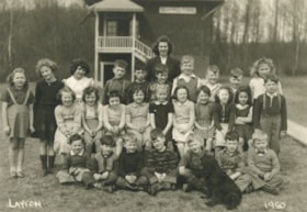
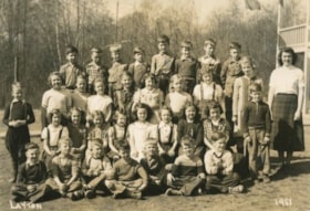
- Scope and Content
- Photograph of twenty-seven students and their teacher seated and standing in rows in front of the school building. A black dog is sitting in the front, facing the rows of children. A label on the back of the photograph states that the students are from Seaforth School. Identified in the photograp…
- Repository
- City of Burnaby Archives
- Date
- 1950
- Collection/Fonds
- Burnaby Historical Society fonds
- Subseries
- Seaforth School subseries
- Physical Description
- 1 photograph : b&w ; 12.5 x 17.7 cm
- Description Level
- Item
- Record No.
- 355-005
- Access Restriction
- No restrictions
- Reproduction Restriction
- Reproduce for fair dealing purposes only
- Accession Number
- BHS1997-14
- Scope and Content
- Photograph of twenty-seven students and their teacher seated and standing in rows in front of the school building. A black dog is sitting in the front, facing the rows of children. A label on the back of the photograph states that the students are from Seaforth School. Identified in the photograph are: Mrs. Mary Johnson (nee MacDonald) teacher, in the far back. Back row (l to r): Sandra ?, Shirley Colden, Marcia Noel, Eldon Clarke, Billy Beaton, David Park, Graeme Smith, Calvert Broomfield, Leigh Tucker and Lillian Savage. Middle row (l to r): Sharon Milne, Gail Simpson, Thelma Mornes, Joan Dachiuk, Barbara Smith, Betty Hadfield, Judy Haddon, Wilma Heather, Merle Beaton and Sammy Savage. Front row (l to r): Dennis Dachiuk, Jerry Hadfield, Mike Lawrence, David MacPhail, Sydney Clarke, Joe Haddon and Jerry Green.
- Subjects
- Animals - Dogs
- Occupations - Teachers
- Names
- Seaforth School
- Johnson, Mary MacDonald
- Colden, Shirley
- Noel, Marcia
- Clarke, Eldon
- Beaton, Billy
- Park, David
- Smith, Graeme
- Broomfield, Calvert
- Tucker, Leigh
- Savage, Lillian
- Anderson, Gail
- Sampson, Gail
- Mornes, Thelma
- Dachiuk, Joan
- Smith, Barbara
- Hadfield, Betty
- Haddon, Judy
- Heather, Wilma
- Beaton, Merle
- Savage, Sammy
- Dachiuk, Dennis
- Hadfield, Jerry
- Lawrence, Mike
- MacPhail, David
- Clarke, Sydney
- Haddon, Joe
- Green, Jerry
- Media Type
- Photograph
- Notes
- Title based on label on verso of photograph
- Photographer identified as "Layton"
- Geographic Access
- Government Road
- Deer Lake Avenue
- Street Address
- 7881 Government Road
- 6501 Deer Lake Avenue
- Historic Neighbourhood
- Lozells (Historic Neighbourhood)
- Planning Study Area
- Government Road Area
Images
Seaforth School Class
https://search.heritageburnaby.ca/link/archivedescription37342
- Repository
- City of Burnaby Archives
- Date
- 1951
- Collection/Fonds
- Burnaby Historical Society fonds
- Description Level
- Item
- Physical Description
- 1 photograph : b&w ; 12.7 x 17.7 cm
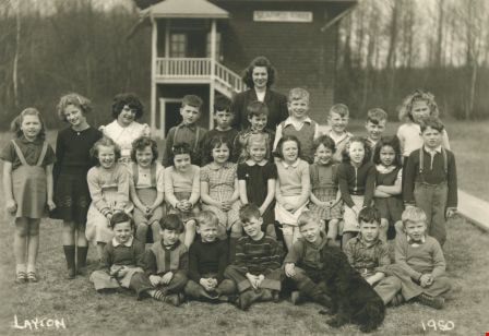
- Scope and Content
- Photograph of twenty-seven students and their teacher seated and standing in rows outside. A label on the back of the photograph states that the students are from Seaforth School. Identified are as follows: Mrs. Mary Johnson (nee MacDonald) teacher, far right. Back row (l to r): Glen Richardson,…
- Repository
- City of Burnaby Archives
- Date
- 1951
- Collection/Fonds
- Burnaby Historical Society fonds
- Subseries
- Seaforth School subseries
- Physical Description
- 1 photograph : b&w ; 12.7 x 17.7 cm
- Description Level
- Item
- Record No.
- 355-006
- Access Restriction
- No restrictions
- Reproduction Restriction
- Reproduce for fair dealing purposes only
- Accession Number
- BHS1997-14
- Scope and Content
- Photograph of twenty-seven students and their teacher seated and standing in rows outside. A label on the back of the photograph states that the students are from Seaforth School. Identified are as follows: Mrs. Mary Johnson (nee MacDonald) teacher, far right. Back row (l to r): Glen Richardson, Leigh Tucker, Brian Clarke, Sammy Savage, Eldon Clarke, David Park, Tommy Richardson, and Joe Haddon. Second row (l to r): Mike Lawrence (standing to the left), Sandra ?, Joan Olsen, Betty Hadfield, Donna Anderson, Wilma Heather, Barbara Smith, Gail Simpson and Shirley Colden. Third row (l to r): Lois Brown, Jackie Peskett, Gail Anderson, Joan Pescott, Merle Beaton, Judy Haddon, Joan Dachiuk, Thelma Mornes, and Jerry Hadfield (standing to the right). Front row (l to r): Dennis Dachiuk, Roy Olsen, David ?, Allen Beaton, Sydney Clarke, David McPhail, and Terry Burstyk.
- Subjects
- Occupations - Teachers
- Names
- Seaforth School
- Johnson, Mary MacDonald
- Richardson, Glen
- Tucker, Leigh
- Clarke, Brian
- Savage, Sammy
- Clarke, Eldon
- Park, David
- Richardson, Tommy
- Haddon, Joe
- Lawrence, Mike
- Olsen, Joan
- Hadfield, Betty
- Anderson, Donna
- Heather, Wilma
- Smith, Barbara
- Sampson, Gail
- Colden, Shirley
- Brown, Lois
- Peskett, Jackie
- Anderson, Gail
- Pescott, Joan
- Beaton, Merle
- Haddon, Judy
- Dachiuk, Joan
- Mornes, Thelma
- Hadfield, Jerry
- Dachiuk, Dennis
- Olsen, Roy
- Beaton, Allen
- Clarke, Sydney
- MacPhail, David
- Burstyk, Terry
- Media Type
- Photograph
- Notes
- Title based on label on verso of photograph
- Photographer identified as "Layton"
- Geographic Access
- Government Road
- Deer Lake Avenue
- Street Address
- 7881 Government Road
- 6501 Deer Lake Avenue
- Historic Neighbourhood
- Lozells (Historic Neighbourhood)
- Planning Study Area
- Government Road Area
Images
