Narrow Results By
Subject
- Buildings 1
- Buildings - Commercial - Grocery Stores 1
- Buildings - Commercial - Stores 2
- Documentary Artifacts - Certificates 1
- Migration 1
- Occupations - Butchers 2
- Occupations - Grocers 2
- Occupations - Truck Drivers 1
- Officials - Mayors and Reeves 2
- Persons - Chinese Canadians 1
- Recreational Activities - Theatre 1
- Transportation - Automobiles 1

Fraser Arm Neighbourhood
https://search.heritageburnaby.ca/link/landmark708
- Repository
- Burnaby Heritage Planning
- Associated Dates
- 1925-1954
- Heritage Value
- By the late 1920s, the Fraser Arm Neighbourhood in Burnaby was developing into an industrial and manufacturing district. In 1931, the Canadian National Railway built a bridge over the Fraser River from Burnaby to Lulu Island and advertised that over 30 industries were currently operating along the North Fraser. Along with industries, this district remained an important agricultural area for the Lower Mainland. Chinese market gardens continued to develop and thrive and in 1926, the Vancouver Sun estimated that that Chinese farms in the Lower Fraser Valley then supplied 90 per cent of all green vegetables consumed in the Vancouver market area.
- Historic Neighbourhood
- Fraser Arm (Historic Neighbourhood)
- Planning Study Area
- Big Bend Area
Images


Burquitlam Neighbourhood
https://search.heritageburnaby.ca/link/landmark757
- Repository
- Burnaby Heritage Planning
- Associated Dates
- 1905-1924
- Heritage Value
- In 1921, the pamphlet "Beautiful Burnaby" was produced and it described the Burquitlam neighbourhood as such: "No part of Burnaby has more consistently laboured to advance its prosperity than Burquitlam. Enterprise and intelligence has hewn homes from the forest and developed land into highly productive gardens and poultry ranches. Burquitlam is the growing suburb to the north of the City of New Westminster. It is reached by the Sapperton carline direct from Edmonds being only a few minutes ride from New Westminster market. It is also served by the B.C.E.R. Burnaby Lake line and adjoins on the best golf links in Greater Vancouver."
- Historic Neighbourhood
- Burquitlam (Historic Neighbourhood)
- Planning Study Area
- Cameron Area
- Lyndhurst Area
Images


Burnaby Lake Neighbourhood
https://search.heritageburnaby.ca/link/landmark755
- Repository
- Burnaby Heritage Planning
- Associated Dates
- 1905-1924
- Heritage Value
- Along with logging and sawmills, Burnaby became known as a prime agricultural area and the Burnaby Lake Neighbourhood saw the development of many vegetable and fruit farms. Growers in the Burnaby and Deer Lake districts took their produce to the tram line on Edmonds Street and shipped it to markets in New Westminster and Vancouver on a specially designed interurban freight car that was open-sided for easy loading. The car's canvas curtains which sometimes came loose and flapped like wings in the wind led people to dub it "the flying dutchman." Most Burnaby fruit and vegetable growers depended on seasonal Chinese work forces and other local Chinese farm residents to oversee operations; these workers being recruited from New Westminsters' Asian community. Besides being good farmers, Burnaby Lake's early residents fostered a strong sense of community. Both L. Claude Hill and his brother Bernard were elected to Burnaby Municipal council and Bernard was the one who knocked on doors to find enough children to meet the qualifications for establishing a school in the district.
- Historic Neighbourhood
- Burnaby Lake (Historic Neighbourhood)
- Planning Study Area
- Morley-Buckingham Area
- Lakeview-Mayfield Area
Images


Head tax certificate issued to Dung Way How
https://search.heritageburnaby.ca/link/museumdescription15546
- Repository
- Burnaby Village Museum
- Date
- 1922-1934 (date of original), copied 2021
- Collection/Fonds
- Burnaby Village Museum Document collection
- Description Level
- Item
- Physical Description
- 1 certificate (tiff) : col. ; 600 dpi
- Scope and Content
- Item consists of a head tax certificate issued by the Dominion of Canada - Immigration Branch - Department of the Interior to Dung Way How (Dong Howe). The certificate was first issued on March 18, 1922 and includes certification stamps on the front along with a photograph of Dung Way How. Certifi…
- Repository
- Burnaby Village Museum
- Collection/Fonds
- Burnaby Village Museum Document collection
- Description Level
- Item
- Physical Description
- 1 certificate (tiff) : col. ; 600 dpi
- Scope and Content
- Item consists of a head tax certificate issued by the Dominion of Canada - Immigration Branch - Department of the Interior to Dung Way How (Dong Howe). The certificate was first issued on March 18, 1922 and includes certification stamps on the front along with a photograph of Dung Way How. Certification stamps on the verso of the certificate were issued by Chinese Immigration authorities between 1922 and 1934. Information on the front of the certificate reads "...This Certifies That / Dung Way How whose photograph is attached / hereto arrived or landed at Vancouver B.C. / on the 23rd day of January 1922 / ex "Empress of Asia" / and upon representations made has been / admitted as exempt from head tax under the / provisions of the Chinese Immigration Act. / The above mentioned party claims / to be a native of Bark Choon Jong in the District of Pon Yue of the age of 20 years. The declaration in this case is C.I.4. No. 3715 Date at Vancouver on March 18, 1922" signed by "Controller of Chinese Immigration". Printed text on verso of certificate reads "IMPORTANT / IT IS NECESSARY THAT THIS / CERTIFICATE BE CAREFULLY / PRESERVED AS IT IS OF VALUE / AS A MEANS OF IDENTIFICATION".
- History
- Dung Way How (Dong Howe) arrived from Bak Chun (North Village), Guangdong in 1922 as a paper son. He had two sons during his first marriage, but the sons remained in China and one died at a young age. He married his second wife Chow Goon Pang through an arranged marriage. She was married twice previously and had a son from each marriage, but neither of them survived. Chow was from Nam Chun (South Village) and arrived in Canada as a paper daughter around the late 1930s or early 1940s. Both Dong and Chow spoke a Poon Yue dialect. The couple raised one daughter Vivian Dong (Dong Jing Yu) in Canada. The Dong family leased and operated the New Fountain hotel in Vancouver located at Abbott Street and Cordova Street. The family later went on to purchase farmland in Burnaby in 1957. The Dong family moved to Burnaby and operated a three acre market garden located at 6220 14th Avenue until 1972. They grew European staples including celery, radishes, green onions, beets, lettuces, endives, as well as Chinese vegetables such as gai lan (Chinese broccoli). There were two Chinese families in the area, including the Wong family who operated the Wong Chew market gardens 6325 14th Avenue. Dong Howe passed away in 1978. Chow Goon Pang passed away in 2000. Their daughter Vivian grew up in Burnaby and attended Riverside Elementary, McPherson Junior High School and Burnaby South Secondary School.
- Creator
- Government of Canada
- Names
- Howe, Dong
- Accession Code
- BV021.13.1
- Access Restriction
- No restrictions
- Reproduction Restriction
- No known restrictions
- Date
- 1922-1934 (date of original), copied 2021
- Media Type
- Textual Record
- Photograph
- Scan Resolution
- 600
- Scan Date
- March 25, 2021
- Scale
- 100
- Notes
- Title based on contents of photograph
Images


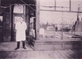
J. Pollard Meat Market
https://search.heritageburnaby.ca/link/archivedescription37357
- Repository
- City of Burnaby Archives
- Date
- 1920 (date of original), copied 1998
- Collection/Fonds
- Burnaby Historical Society fonds
- Description Level
- Item
- Physical Description
- 1 photograph : b&w ; 12.8 x 17.5 cm
- Scope and Content
- Photograph of Joseph Pollard standing outside the J. Pollard Meat Market at Kingsway and Edmonds.
- Repository
- City of Burnaby Archives
- Date
- 1920 (date of original), copied 1998
- Collection/Fonds
- Burnaby Historical Society fonds
- Subseries
- Pollard family subseries
- Physical Description
- 1 photograph : b&w ; 12.8 x 17.5 cm
- Description Level
- Item
- Record No.
- 359-003
- Access Restriction
- No restrictions
- Reproduction Restriction
- No known restrictions
- Accession Number
- BHS1998-09
- Scope and Content
- Photograph of Joseph Pollard standing outside the J. Pollard Meat Market at Kingsway and Edmonds.
- Names
- Pollard, Joseph
- Media Type
- Photograph
- Notes
- Title based on contents of photograph.
- Geographic Access
- Kingsway
- Edmonds Street
- Historic Neighbourhood
- Edmonds (Historic Neighbourhood)
- Planning Study Area
- Edmonds Area
Images

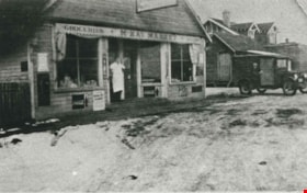
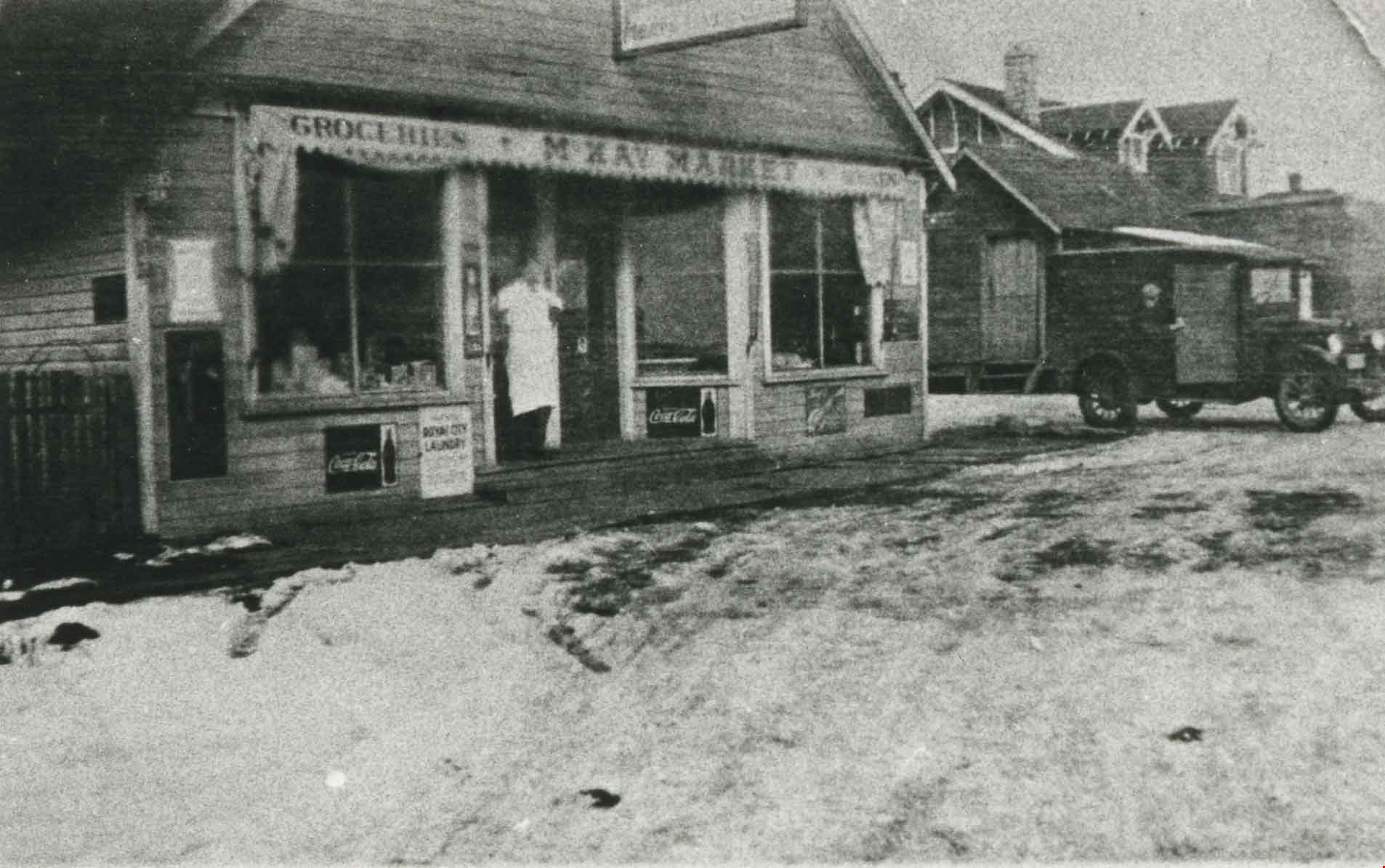
McKay Market
https://search.heritageburnaby.ca/link/archivedescription35746
- Repository
- City of Burnaby Archives
- Date
- 1926 (date of original), copied 1986
- Collection/Fonds
- Burnaby Historical Society fonds
- Description Level
- Item
- Physical Description
- 1 photograph : b&w ; 12.7 x 17.8 cm print
- Scope and Content
- Photograph of McKay Market at 2624 McKay Avenue (later renumbered 6555 McKay Avenue). Identified: (back) Ed Morash, driver of delivery truck (brother of Murial Morash Crosby); (in doorway) William Tate Wilson, store owner and later Reeve of Burnaby, 1943-44.
- Repository
- City of Burnaby Archives
- Date
- 1926 (date of original), copied 1986
- Collection/Fonds
- Burnaby Historical Society fonds
- Subseries
- Pioneer Tales subseries
- Physical Description
- 1 photograph : b&w ; 12.7 x 17.8 cm print
- Description Level
- Item
- Record No.
- 204-604
- Access Restriction
- No restrictions
- Reproduction Restriction
- No known restrictions
- Accession Number
- BHS1988-03
- Scope and Content
- Photograph of McKay Market at 2624 McKay Avenue (later renumbered 6555 McKay Avenue). Identified: (back) Ed Morash, driver of delivery truck (brother of Murial Morash Crosby); (in doorway) William Tate Wilson, store owner and later Reeve of Burnaby, 1943-44.
- Subjects
- Buildings - Commercial - Grocery Stores
- Occupations - Truck Drivers
- Occupations - Grocers
- Officials - Mayors and Reeves
- Media Type
- Photograph
- Notes
- Title based on contents of photograph
- Geographic Access
- McKay Avenue
- Street Address
- 6555 McKay Avenue
- Historic Neighbourhood
- Central Park (Historic Neighbourhood)
- Planning Study Area
- Maywood Area
Images
![Rose Meat Market on Kingsway, [192-] (date of original), copied 1992 thumbnail](/media/hpo/_Data/_Archives_Images/_Unrestricted/315/315-052.jpg?width=280)
Rose Meat Market on Kingsway
https://search.heritageburnaby.ca/link/archivedescription36697
- Repository
- City of Burnaby Archives
- Date
- [192-] (date of original), copied 1992
- Collection/Fonds
- Burnaby Historical Society fonds
- Description Level
- Item
- Physical Description
- 1 photograph : b&w ; 12.5 x 8.5 cm print
- Scope and Content
- Photograph of the exterior of Rose Meat Market on Kingsway, an addition to Allen Sharpe's sign shop and store. Mr. Sharpe is on the right and Gwynne Everett Morris is on the left. Allen and Rose Sharpe had bought the property in 1919.
- Repository
- City of Burnaby Archives
- Date
- [192-] (date of original), copied 1992
- Collection/Fonds
- Burnaby Historical Society fonds
- Subseries
- Burnaby Centennial Anthology subseries
- Physical Description
- 1 photograph : b&w ; 12.5 x 8.5 cm print
- Description Level
- Item
- Record No.
- 315-052
- Access Restriction
- No restrictions
- Reproduction Restriction
- No known restrictions
- Accession Number
- BHS1994-04
- Scope and Content
- Photograph of the exterior of Rose Meat Market on Kingsway, an addition to Allen Sharpe's sign shop and store. Mr. Sharpe is on the right and Gwynne Everett Morris is on the left. Allen and Rose Sharpe had bought the property in 1919.
- Media Type
- Photograph
- Notes
- Title based on contents of photograph
- Geographic Access
- Kingsway
- Kathleen Avenue
- Street Address
- 4360 Kingsway
- Historic Neighbourhood
- Central Park (Historic Neighbourhood)
- Planning Study Area
- Maywood Area
Images
![Rose Meat Market on Kingsway, [192-] (date of original), copied 1992 thumbnail](/media/hpo/_Data/_Archives_Images/_Unrestricted/315/315-052.jpg)
![William Parker with P. Burns & Co. automobile, [c. 1915] thumbnail](/media/hpo/_Data/_BVM_Images/2022/2022_0032_0052_001.jpg?width=280)
William Parker with P. Burns & Co. automobile
https://search.heritageburnaby.ca/link/museumdescription19335
- Repository
- Burnaby Village Museum
- Date
- [c. 1915]
- Collection/Fonds
- Esther Love Stanley fonds
- Description Level
- Item
- Physical Description
- 1 photograph : b&w ; 8 x 11 cm
- Scope and Content
- Photograph of William Michael Parker standing next to a Model T. Ford with the lettering "P.Burns & Co." painted on the side. William Parker is wearing a long white coat, wool cap and black tie. The car is on a dirt road with a young forest of conifers behind. William worked as a manager for P.Burn…
- Repository
- Burnaby Village Museum
- Collection/Fonds
- Esther Love Stanley fonds
- Description Level
- Item
- Physical Description
- 1 photograph : b&w ; 8 x 11 cm
- Scope and Content
- Photograph of William Michael Parker standing next to a Model T. Ford with the lettering "P.Burns & Co." painted on the side. William Parker is wearing a long white coat, wool cap and black tie. The car is on a dirt road with a young forest of conifers behind. William worked as a manager for P.Burns & Co. from 1921-1935 and was the proprietor of Tenth Street Meat Market (306 10th Street) from 1936 and retired in 1957. P. Burns & Co. was a market that had many franchises in western Canada and became Burns & Co. in 1928.
- Subjects
- Transportation - Automobiles
- Accession Code
- BV022.32.52
- Access Restriction
- No restrictions
- Reproduction Restriction
- No known restrictions
- Date
- [c. 1915]
- Media Type
- Photograph
- Scan Resolution
- 600
- Scan Date
- 2023-04-04
- Notes
- Title based on contents of photograph
- Photograph is part of Esther Love Stanley photograph album 1 (BV022.32.1)
- Note in white ink on album page reads: "WILL PARKER / MARRIED SARAH"
Images
![William Parker with P. Burns & Co. automobile, [c. 1915] thumbnail](/media/hpo/_Data/_BVM_Images/2022/2022_0032_0052_001.jpg)
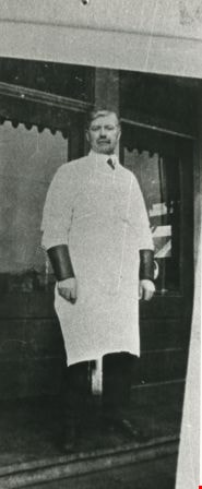
William Tate Wilson
https://search.heritageburnaby.ca/link/archivedescription35747
- Repository
- City of Burnaby Archives
- Date
- 1926 (date of original), copied 1986
- Collection/Fonds
- Burnaby Historical Society fonds
- Description Level
- Item
- Physical Description
- 1 photograph : b&w ; 12.7 x 17.8 cm print
- Scope and Content
- Photograph of William Tate Wilson, owner of McKay Market and later Reeve of Burnaby, 1943-44. McKay Market was located at 2624 McKay Avenue (later renumbered 6555 McKay Avenue).
- Repository
- City of Burnaby Archives
- Date
- 1926 (date of original), copied 1986
- Collection/Fonds
- Burnaby Historical Society fonds
- Subseries
- Pioneer Tales subseries
- Physical Description
- 1 photograph : b&w ; 12.7 x 17.8 cm print
- Description Level
- Item
- Record No.
- 204-605
- Access Restriction
- No restrictions
- Reproduction Restriction
- No known restrictions
- Accession Number
- BHS1988-03
- Scope and Content
- Photograph of William Tate Wilson, owner of McKay Market and later Reeve of Burnaby, 1943-44. McKay Market was located at 2624 McKay Avenue (later renumbered 6555 McKay Avenue).
- Media Type
- Photograph
- Notes
- Title based on contents of photograph
- Geographic Access
- McKay Avenue
- Street Address
- 6555 McKay Avenue
- Historic Neighbourhood
- Central Park (Historic Neighbourhood)
- Planning Study Area
- Maywood Area
Images

![Rosemount Viaduct, Aberdeen, [1900-1930] thumbnail](/media/hpo/_Data/_Archives_Images/_Unrestricted/550/550-142.jpg?width=280)
Rosemount Viaduct, Aberdeen
https://search.heritageburnaby.ca/link/archivedescription82571
- Repository
- City of Burnaby Archives
- Date
- [1900-1930]
- Collection/Fonds
- Hill family and Vidal family fonds
- Description Level
- Item
- Physical Description
- 1 photograph : b&w postcard ; 8.5 x 13.5 cm
- Scope and Content
- Photographic postcard shows Rosemount Viaduct in Aberdeen, Scotland. Statue on the left is the William Wallace statue. Building to the right is His Majesty's Theatre.
- Repository
- City of Burnaby Archives
- Date
- [1900-1930]
- Collection/Fonds
- Hill family and Vidal family fonds
- Physical Description
- 1 photograph : b&w postcard ; 8.5 x 13.5 cm
- Description Level
- Item
- Record No.
- 550-142
- Access Restriction
- No restrictions
- Reproduction Restriction
- No known restrictions
- Accession Number
- 2013-03
- Scope and Content
- Photographic postcard shows Rosemount Viaduct in Aberdeen, Scotland. Statue on the left is the William Wallace statue. Building to the right is His Majesty's Theatre.
- Media Type
- Photograph
- Notes
- Title based on contents of photograph
- Postcard on verso reads: "Published by T Lamb, 40, Market Street, Aberdeen"
Images
![Rosemount Viaduct, Aberdeen, [1900-1930] thumbnail](/media/hpo/_Data/_Archives_Images/_Unrestricted/550/550-142.jpg)