More like 'Burrard Inlet in winter'
Narrow Results By
Decade
- 2020s 119
- 2010s 118
- 2000s 685
- 1990s 660
- 1980s 492
- 1970s 967
- 1960s 404
- 1950s 554
- 1940s 622
- 1930s 654
- 1920s
- 1910s 617
- 1900s 272
- 1890s 38
- 1880s 70
- 1870s 5
- 1860s 3
- 1850s 1
- 1840s 1
- 1830s 1
- 1820s 1
- 1810s 1
- 1800s 1
- 1790s 1
- 1780s 1
- 1770s 1
- 1760s 1
- 1750s 1
- 1740s 1
- 1730s 1
- 1720s 1
- 1710s 1
- 1700s 1
- 1690s 1
- 1680s 1
- 1670s 1
- 1660s 1
- 1650s 1
- 1640s 1
- 1630s 1
- 1620s 1
- 1610s 1
- 1600s 1
Subject
- Accidents - Automobile Accidents 2
- Advertising Medium - Signs and Signboards 9
- Aerial Photographs 1
- Agricultural Tools and Equipment - Plows 1
- Agriculture 1
- Agriculture - Farms 11
- Agriculture - Fruit and Berries 1
- Agriculture - Poultry 3
- Animals - Cats 2
- Animals - Cows 1
- Animals - Deer 1
- Animals - Dogs 12
![Mary Warren and Bill Anthony, [192-] (date of original), copied 1986 thumbnail](/media/hpo/_Data/_Archives_Images/_Unrestricted/204/204-404.jpg?width=280)
Mary Warren and Bill Anthony
https://search.heritageburnaby.ca/link/archivedescription35546
- Repository
- City of Burnaby Archives
- Date
- [192-] (date of original), copied 1986
- Collection/Fonds
- Burnaby Historical Society fonds
- Description Level
- Item
- Physical Description
- 1 photograph : b&w ; 12.7 x 17.8 cm print
- Scope and Content
- Photograph of Mary Warren and Bill Anthony, west of the Warren family home at 4264 Union Street. The street did not extend past the Warren house. A "corduroy" road was used in the early years: split cedar logs placed side by side.
- Repository
- City of Burnaby Archives
- Date
- [192-] (date of original), copied 1986
- Collection/Fonds
- Burnaby Historical Society fonds
- Subseries
- Pioneer Tales subseries
- Physical Description
- 1 photograph : b&w ; 12.7 x 17.8 cm print
- Description Level
- Item
- Record No.
- 204-404
- Access Restriction
- No restrictions
- Reproduction Restriction
- No known restrictions
- Accession Number
- BHS1988-03
- Scope and Content
- Photograph of Mary Warren and Bill Anthony, west of the Warren family home at 4264 Union Street. The street did not extend past the Warren house. A "corduroy" road was used in the early years: split cedar logs placed side by side.
- Media Type
- Photograph
- Notes
- Title based on contents of photograph
- Geographic Access
- Union Street
- Street Address
- 4264 Union Street
- Historic Neighbourhood
- Vancouver Heights (Historic Neighbourhood)
- Planning Study Area
- Willingdon Heights Area
Images
![Mary Warren and Bill Anthony, [192-] (date of original), copied 1986 thumbnail](/media/hpo/_Data/_Archives_Images/_Unrestricted/204/204-404.jpg)

Peggy Urquhart
https://search.heritageburnaby.ca/link/archivedescription35280
- Repository
- City of Burnaby Archives
- Date
- 1924 (date of original), copied 1986
- Collection/Fonds
- Burnaby Historical Society fonds
- Description Level
- Item
- Physical Description
- 1 photograph : b&w ; 12.7 x 17.8 cm print
- Scope and Content
- Photograph of Peggy Urquhart with a pet dog and cat in front of the family home, "Rowanlea." William Urquhart built this house for his family around 1919 at Griffiths Avenue and Burford Street (Edmonds area). The house was previously numbered 2674, then changed to 6625, and later 6637 Griffiths A…
- Repository
- City of Burnaby Archives
- Date
- 1924 (date of original), copied 1986
- Collection/Fonds
- Burnaby Historical Society fonds
- Subseries
- Pioneer Tales subseries
- Physical Description
- 1 photograph : b&w ; 12.7 x 17.8 cm print
- Description Level
- Item
- Record No.
- 204-137
- Access Restriction
- No restrictions
- Reproduction Restriction
- No known restrictions
- Accession Number
- BHS1988-03
- Scope and Content
- Photograph of Peggy Urquhart with a pet dog and cat in front of the family home, "Rowanlea." William Urquhart built this house for his family around 1919 at Griffiths Avenue and Burford Street (Edmonds area). The house was previously numbered 2674, then changed to 6625, and later 6637 Griffiths Avenue.
- Subjects
- Animals - Cats
- Animals - Dogs
- Buildings - Residential - Houses
- Geographic Features - Gardens
- Media Type
- Photograph
- Notes
- Title based on contents of photograph
- Geographic Access
- Griffiths Avenue
- Street Address
- 6637 Griffiths Avenue
- Historic Neighbourhood
- Edmonds (Historic Neighbourhood)
- Planning Study Area
- Kingsway-Beresford Area
Images

![Urquhart family home, [1920] (date of original), copied 1986 thumbnail](/media/hpo/_Data/_Archives_Images/_Unrestricted/204/204-146.jpg?width=280)
Urquhart family home
https://search.heritageburnaby.ca/link/archivedescription35289
- Repository
- City of Burnaby Archives
- Date
- [1920] (date of original), copied 1986
- Collection/Fonds
- Burnaby Historical Society fonds
- Description Level
- Item
- Physical Description
- 1 photograph : b&w ; 12.7 x 17.8 cm print
- Scope and Content
- Photograph of the backyard garden at "Rowanlea" including Peggy's swing. "Rowanlea" was the home of William Urquhart, his wife, Lillias Urquhart, and daughter Margaret Urquhart (aka Peggy Urquhart). William and Lillias were expert gardeners. The house was previously numbered 2674, then changed to …
- Repository
- City of Burnaby Archives
- Date
- [1920] (date of original), copied 1986
- Collection/Fonds
- Burnaby Historical Society fonds
- Subseries
- Pioneer Tales subseries
- Physical Description
- 1 photograph : b&w ; 12.7 x 17.8 cm print
- Description Level
- Item
- Record No.
- 204-146
- Access Restriction
- No restrictions
- Reproduction Restriction
- No known restrictions
- Accession Number
- BHS1988-03
- Scope and Content
- Photograph of the backyard garden at "Rowanlea" including Peggy's swing. "Rowanlea" was the home of William Urquhart, his wife, Lillias Urquhart, and daughter Margaret Urquhart (aka Peggy Urquhart). William and Lillias were expert gardeners. The house was previously numbered 2674, then changed to 6625, and later 6637 Griffiths Avenue.
- Media Type
- Photograph
- Notes
- Title based on contents of photograph
- Geographic Access
- Griffiths Avenue
- Burford Street
- Street Address
- 6637 Griffiths Avenue
- Historic Neighbourhood
- Edmonds (Historic Neighbourhood)
Images
![Urquhart family home, [1920] (date of original), copied 1986 thumbnail](/media/hpo/_Data/_Archives_Images/_Unrestricted/204/204-146.jpg)
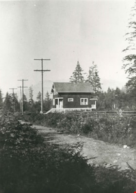
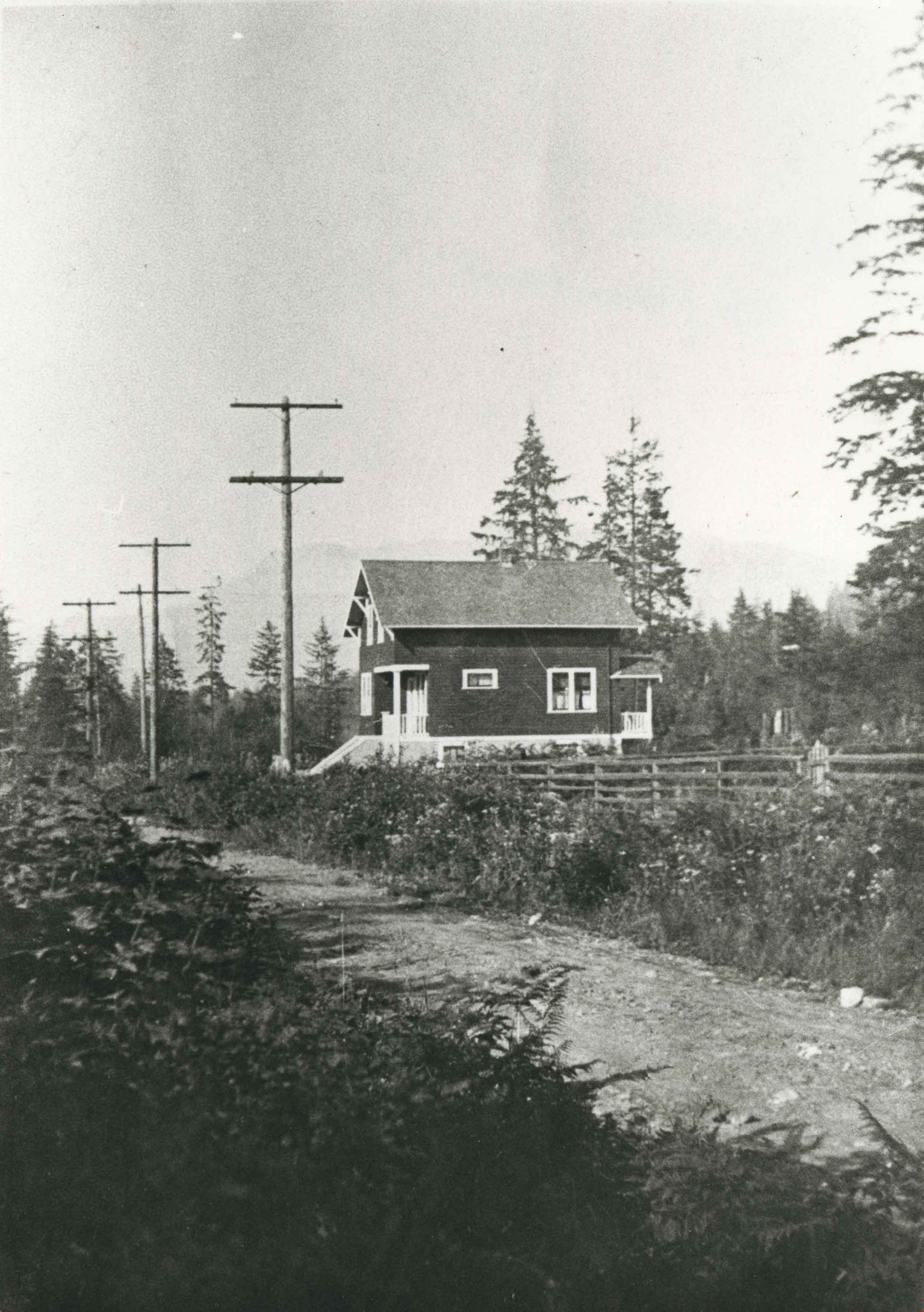
White family home
https://search.heritageburnaby.ca/link/archivedescription35176
- Repository
- City of Burnaby Archives
- Date
- 1920 (date of original), copied 1986
- Collection/Fonds
- Burnaby Historical Society fonds
- Description Level
- Item
- Physical Description
- 1 photograph : b&w ; 12.7 x 17.8 cm print
- Scope and Content
- Photograph of the White family home near the corner of Beta Avenue and Pender Street (506 Beta Avenue) in North Burnaby. The family moved their belongings here with wheelbarrows.
- Repository
- City of Burnaby Archives
- Date
- 1920 (date of original), copied 1986
- Collection/Fonds
- Burnaby Historical Society fonds
- Subseries
- Pioneer Tales subseries
- Physical Description
- 1 photograph : b&w ; 12.7 x 17.8 cm print
- Description Level
- Item
- Record No.
- 204-033
- Access Restriction
- No restrictions
- Reproduction Restriction
- No known restrictions
- Accession Number
- BHS1988-03
- Scope and Content
- Photograph of the White family home near the corner of Beta Avenue and Pender Street (506 Beta Avenue) in North Burnaby. The family moved their belongings here with wheelbarrows.
- Media Type
- Photograph
- Notes
- Title based on contents of photograph
- Geographic Access
- Beta Avenue
- Street Address
- 506 Beta Avenue
- Historic Neighbourhood
- Capitol Hill (Historic Neighbourhood)
- Planning Study Area
- Brentwood Area
Images
![C.P.R. line, [192-] thumbnail](/media/hpo/_Data/_BVM_Images/2007/2007_0045_0014_001.jpg?width=280)
C.P.R. line
https://search.heritageburnaby.ca/link/museumdescription3898
- Repository
- Burnaby Village Museum
- Date
- [192-]
- Collection/Fonds
- Burnaby Village Museum Photograph collection
- Description Level
- Item
- Physical Description
- 1 photograph : b&w ; 11.5 x 7 cm
- Scope and Content
- Photograph of a trail overlooking Burrard Inlet that runs down a hill through some evergreen trees.
- Repository
- Burnaby Village Museum
- Collection/Fonds
- Burnaby Village Museum Photograph collection
- Description Level
- Item
- Physical Description
- 1 photograph : b&w ; 11.5 x 7 cm
- Material Details
- "You asked me how / far the CPR Line / was from our lot / It is within 1/4 mile / This was taken / right above the / CPR line, there is / quite a sharp descent / from here down to the / line If the piece of / bush to the left was / cut you would see 2nd narrows bridge" written in pencil on the back of the photo.
- Scope and Content
- Photograph of a trail overlooking Burrard Inlet that runs down a hill through some evergreen trees.
- History
- George Vincent Martin was born in 1892 in England. He married Matilda Florence Reed in 1916. He purchased a property in North Burnaby in the 1920s on Trinity Street. There was a main house and a "shack" on the property split up onto two lots.
- Accession Code
- BV007.45.14
- Access Restriction
- No restrictions
- Reproduction Restriction
- No known restrictions
- Date
- [192-]
- Media Type
- Photograph
- Scan Resolution
- 300
- Scan Date
- 29-Nov-2018
- Scale
- 96
- Notes
- Title based on notes on the reverse of the photograph
Images
![C.P.R. line, [192-] thumbnail](/media/hpo/_Data/_BVM_Images/2007/2007_0045_0014_001.jpg)
![Knight Inlet, [between 1925 and 1940] thumbnail](/media/hpo/_Data/_Archives_Images/_Unrestricted/550/550-172.jpg?width=280)
Knight Inlet
https://search.heritageburnaby.ca/link/archivedescription82607
- Repository
- City of Burnaby Archives
- Date
- [between 1925 and 1940]
- Collection/Fonds
- Hill family and Vidal family fonds
- Description Level
- Item
- Physical Description
- 1 photograph : sepia ; 9 x 6.5 cm
- Scope and Content
- Photograph shows a tree in a clearing.
- Repository
- City of Burnaby Archives
- Date
- [between 1925 and 1940]
- Collection/Fonds
- Hill family and Vidal family fonds
- Physical Description
- 1 photograph : sepia ; 9 x 6.5 cm
- Description Level
- Item
- Record No.
- 550-172
- Access Restriction
- No restrictions
- Reproduction Restriction
- No known restrictions
- Accession Number
- 2013-03
- Scope and Content
- Photograph shows a tree in a clearing.
- Media Type
- Photograph
- Notes
- Title based on note accompanying photograph
- Note in pencil on album page reads: "Knight Inlet"
- Photograph stamp on verso reads: "Crystal Finish / will not fade"
Images
![Knight Inlet, [between 1925 and 1940] thumbnail](/media/hpo/_Data/_Archives_Images/_Unrestricted/550/550-172.jpg)
![Knight Inlet, [between 1925 and 1940] thumbnail](/media/hpo/_Data/_Archives_Images/_Unrestricted/550/550-173.jpg?width=280)
Knight Inlet
https://search.heritageburnaby.ca/link/archivedescription82608
- Repository
- City of Burnaby Archives
- Date
- [between 1925 and 1940]
- Collection/Fonds
- Hill family and Vidal family fonds
- Description Level
- Item
- Physical Description
- 1 photograph : sepia ; 9 x 6.5 cm
- Scope and Content
- Photograph shows a tree in a clearing being felled.
- Repository
- City of Burnaby Archives
- Date
- [between 1925 and 1940]
- Collection/Fonds
- Hill family and Vidal family fonds
- Physical Description
- 1 photograph : sepia ; 9 x 6.5 cm
- Description Level
- Item
- Record No.
- 550-173
- Access Restriction
- No restrictions
- Reproduction Restriction
- No known restrictions
- Accession Number
- 2013-03
- Scope and Content
- Photograph shows a tree in a clearing being felled.
- Media Type
- Photograph
- Notes
- Title based on note accompanying photograph
- Note in pencil on page photograph is mounted on reads: "Knight Inlet"
- Photograph stamp on verso reads: "Crystal Finish / will not fade"
Images
![Knight Inlet, [between 1925 and 1940] thumbnail](/media/hpo/_Data/_Archives_Images/_Unrestricted/550/550-173.jpg)
![Knight Inlet, [between 1925 and 1940] thumbnail](/media/hpo/_Data/_Archives_Images/_Unrestricted/550/550-174.jpg?width=280)
Knight Inlet
https://search.heritageburnaby.ca/link/archivedescription82609
- Repository
- City of Burnaby Archives
- Date
- [between 1925 and 1940]
- Collection/Fonds
- Hill family and Vidal family fonds
- Description Level
- Item
- Physical Description
- 1 photograph : sepia ; 9 x 6.5 cm
- Scope and Content
- Photograph shows a tree trunk in a clearing.
- Repository
- City of Burnaby Archives
- Date
- [between 1925 and 1940]
- Collection/Fonds
- Hill family and Vidal family fonds
- Physical Description
- 1 photograph : sepia ; 9 x 6.5 cm
- Description Level
- Item
- Record No.
- 550-174
- Access Restriction
- No restrictions
- Reproduction Restriction
- No known restrictions
- Accession Number
- 2013-03
- Scope and Content
- Photograph shows a tree trunk in a clearing.
- Media Type
- Photograph
- Notes
- Title based on note accompanying photograph
- Note in pencil on page photograph is mounted on reads: "Knight Inlet"
- Photograph stamp on verso reads: "Crystal Finish / will not fade"
Images
![Knight Inlet, [between 1925 and 1940] thumbnail](/media/hpo/_Data/_Archives_Images/_Unrestricted/550/550-174.jpg)
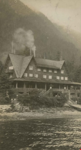
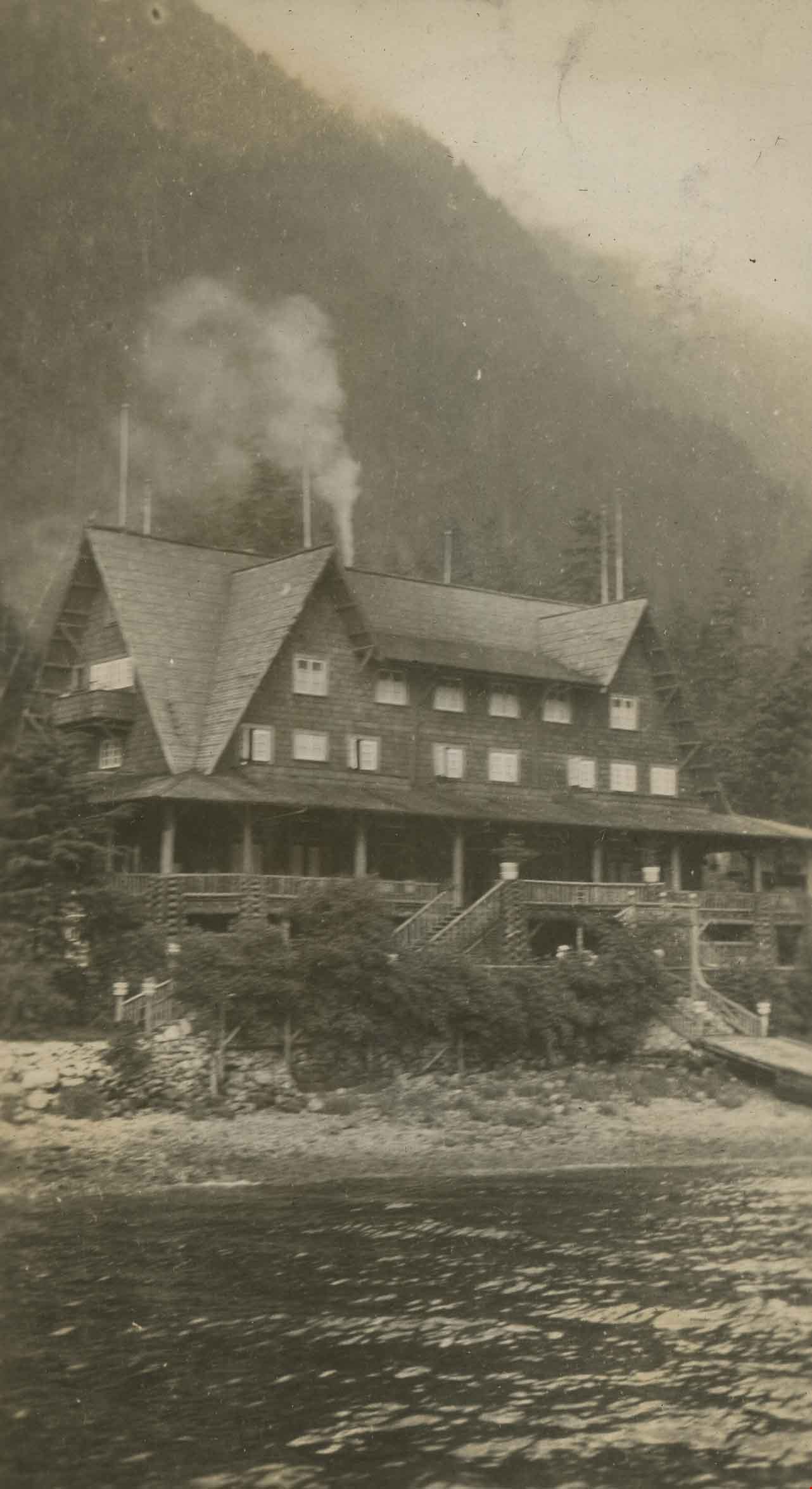
Wigwam Inn
https://search.heritageburnaby.ca/link/archivedescription39237
- Repository
- City of Burnaby Archives
- Date
- 1923
- Collection/Fonds
- Peers Family and Hill Family fonds
- Description Level
- Item
- Physical Description
- 1 photograph : b&w ; 5.5 x 10 cm on page 24.5 x 32.5 cm (pasted in album)
- Scope and Content
- Photograph of the Wigwam Inn, which is located at the northern end of Indian Arm of Burrard Inlet.
- Repository
- City of Burnaby Archives
- Date
- 1923
- Collection/Fonds
- Peers Family and Hill Family fonds
- Physical Description
- 1 photograph : b&w ; 5.5 x 10 cm on page 24.5 x 32.5 cm (pasted in album)
- Description Level
- Item
- Record No.
- 477-556
- Access Restriction
- No restrictions
- Reproduction Restriction
- No known restrictions
- Accession Number
- 2007-12
- Scope and Content
- Photograph of the Wigwam Inn, which is located at the northern end of Indian Arm of Burrard Inlet.
- Names
- Wigwam Inn
- Media Type
- Photograph
- Notes
- Title based on caption accompanying photograph
Images

At the river's edge
https://search.heritageburnaby.ca/link/archivedescription34445
- Repository
- City of Burnaby Archives
- Date
- 1927
- Collection/Fonds
- Burnaby Historical Society fonds
- Description Level
- Item
- Physical Description
- 1 photograph : b&w ; 6.8 x 12 cm on page 17.4 x 26 cm
- Scope and Content
- Photograph of a house sitting near the river bank in the vicinity of Nicomen Island, Deroche and Dewndey. Mountains are visible in the background
- Repository
- City of Burnaby Archives
- Date
- 1927
- Collection/Fonds
- Burnaby Historical Society fonds
- Subseries
- Peers family subseries
- Physical Description
- 1 photograph : b&w ; 6.8 x 12 cm on page 17.4 x 26 cm
- Description Level
- Item
- Record No.
- 020-152
- Access Restriction
- No restrictions
- Reproduction Restriction
- No known restrictions
- Accession Number
- BHS2007-04
- Scope and Content
- Photograph of a house sitting near the river bank in the vicinity of Nicomen Island, Deroche and Dewndey. Mountains are visible in the background
- Media Type
- Photograph
- Notes
- Title based on contents of photograph
Images


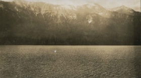
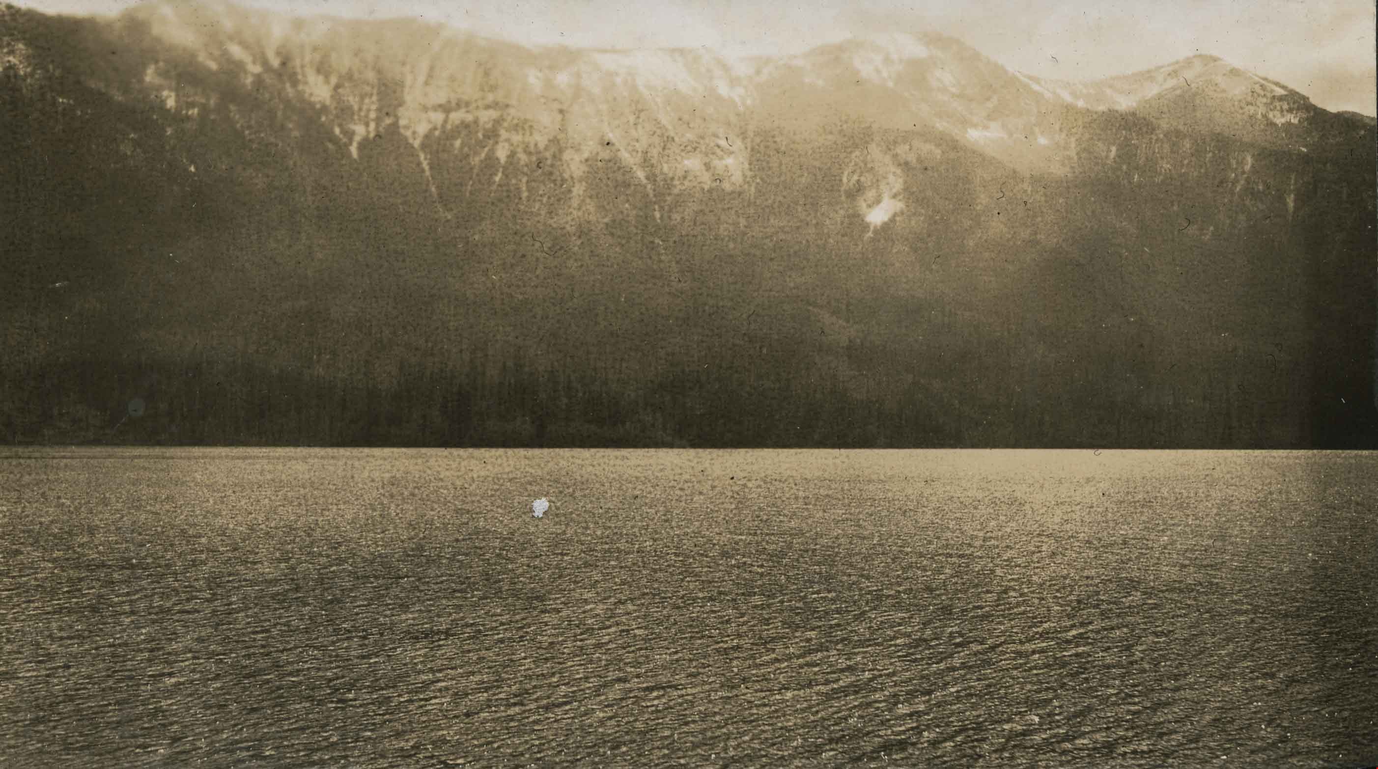
Burnaby Lake
https://search.heritageburnaby.ca/link/archivedescription34563
- Repository
- City of Burnaby Archives
- Date
- 1923
- Collection/Fonds
- Burnaby Historical Society fonds
- Description Level
- Item
- Physical Description
- 1 photograph : b&w ; 17.4 x 35.3 cm
- Scope and Content
- Photograph of Burnaby Lake, looking northwest. The north shore mountains, including The Lions, can be seen in the background.
- Repository
- City of Burnaby Archives
- Date
- 1923
- Collection/Fonds
- Burnaby Historical Society fonds
- Subseries
- Photographs subseries
- Physical Description
- 1 photograph : b&w ; 17.4 x 35.3 cm
- Description Level
- Item
- Record No.
- 050-001
- Access Restriction
- No restrictions
- Reproduction Restriction
- No known restrictions
- Accession Number
- BHS2007-04
- Scope and Content
- Photograph of Burnaby Lake, looking northwest. The north shore mountains, including The Lions, can be seen in the background.
- Media Type
- Photograph
- Notes
- Title based on contents of photograph
- Geographic Access
- Burnaby Lake
- Historic Neighbourhood
- Burnaby Lake (Historic Neighbourhood)
- Planning Study Area
- Burnaby Lake Area
Images


Burnaby Park
https://search.heritageburnaby.ca/link/archivedescription34577
- Repository
- City of Burnaby Archives
- Date
- 1927
- Collection/Fonds
- Burnaby Historical Society fonds
- Description Level
- Item
- Physical Description
- 1 photograph : b&w ; 34.5 x 23.3 cm mounted on 49.5 x 35.1 cm cardboard
- Scope and Content
- Photograph taken from Burnaby Park, including trees and mountains in the distance.
- Repository
- City of Burnaby Archives
- Date
- 1927
- Collection/Fonds
- Burnaby Historical Society fonds
- Subseries
- Photographs subseries
- Physical Description
- 1 photograph : b&w ; 34.5 x 23.3 cm mounted on 49.5 x 35.1 cm cardboard
- Description Level
- Item
- Record No.
- 055-002
- Access Restriction
- No restrictions
- Reproduction Restriction
- No known restrictions
- Accession Number
- BHS2007-04
- Scope and Content
- Photograph taken from Burnaby Park, including trees and mountains in the distance.
- Media Type
- Photograph
- Photographer
- Lloyd's Studio
- Notes
- Title based on contents of photograph
- Annotation on bottom front of cardboard reads, "Burnaby Park / Officially Opened August 6th, 1927"
- Geographic Access
- Robert Burnaby Park
- Wedgewood Street
- Street Address
- 8155 Wedgewood Street
- Historic Neighbourhood
- Burnaby Lake (Historic Neighbourhood)
- Planning Study Area
- Lakeview-Mayfield Area
Images


Cable Crossing at Mile 57
https://search.heritageburnaby.ca/link/archivedescription34397
- Repository
- City of Burnaby Archives
- Date
- 1926
- Collection/Fonds
- Burnaby Historical Society fonds
- Description Level
- Item
- Physical Description
- 1 photograph : b&w ; 7.2 x 9.5 cm on page 17.4 x 26.2 cm
- Scope and Content
- Photograph taken looking over a river towards Cheam Peak, which is visible in the background. A cable can be seen stretching over the river. This photograph appears to have been taken by Arthur Peers, who travelled through the Fraser River Valley and worked on the construction of the Trans-Provinc…
- Repository
- City of Burnaby Archives
- Date
- 1926
- Collection/Fonds
- Burnaby Historical Society fonds
- Subseries
- Peers family subseries
- Physical Description
- 1 photograph : b&w ; 7.2 x 9.5 cm on page 17.4 x 26.2 cm
- Description Level
- Item
- Record No.
- 020-104
- Access Restriction
- No restrictions
- Reproduction Restriction
- No known restrictions
- Accession Number
- BHS2007-04
- Scope and Content
- Photograph taken looking over a river towards Cheam Peak, which is visible in the background. A cable can be seen stretching over the river. This photograph appears to have been taken by Arthur Peers, who travelled through the Fraser River Valley and worked on the construction of the Trans-Provincial Highway during the later 1920s.
- Media Type
- Photograph
- Photographer
- Peers, Arthur Francis "Mike"
- Notes
- Title based on caption accompanying photograph
Images

Cultus Lake
https://search.heritageburnaby.ca/link/archivedescription34393
- Repository
- City of Burnaby Archives
- Date
- 1926
- Collection/Fonds
- Burnaby Historical Society fonds
- Description Level
- Item
- Physical Description
- 1 photograph : b&w ; 6.7 x 12 cm on page 17.4 x 26.4 cm
- Scope and Content
- Photograph taken looking over Cultus Lake towards the mountains. This photograph appears to have been taken by Arthur Peers, who travelled through the Fraser River Valley and worked on the construction of the Trans-Provincial Highway during the later 1920s.
- Repository
- City of Burnaby Archives
- Date
- 1926
- Collection/Fonds
- Burnaby Historical Society fonds
- Subseries
- Peers family subseries
- Physical Description
- 1 photograph : b&w ; 6.7 x 12 cm on page 17.4 x 26.4 cm
- Description Level
- Item
- Record No.
- 020-100
- Access Restriction
- No restrictions
- Reproduction Restriction
- No known restrictions
- Accession Number
- BHS2007-04
- Scope and Content
- Photograph taken looking over Cultus Lake towards the mountains. This photograph appears to have been taken by Arthur Peers, who travelled through the Fraser River Valley and worked on the construction of the Trans-Provincial Highway during the later 1920s.
- Media Type
- Photograph
- Photographer
- Peers, Arthur Francis "Mike"
- Notes
- Title based on caption accompanying photograph
Images

Cultus Lake
https://search.heritageburnaby.ca/link/archivedescription34396
- Repository
- City of Burnaby Archives
- Date
- 1926
- Collection/Fonds
- Burnaby Historical Society fonds
- Description Level
- Item
- Physical Description
- 1 photograph : b&w ; 7 x 12.2 cm on page 17.4 x 26.2 cm
- Scope and Content
- Photograph of Cultus Lake, looking towards the mountains. A wooden pier can be seen in the foreground and a row of cabins are visible on the far shore. This photograph appears to have been taken by Arthur Peers, who travelled through the Fraser River Valley and worked on the construction of the T…
- Repository
- City of Burnaby Archives
- Date
- 1926
- Collection/Fonds
- Burnaby Historical Society fonds
- Subseries
- Peers family subseries
- Physical Description
- 1 photograph : b&w ; 7 x 12.2 cm on page 17.4 x 26.2 cm
- Description Level
- Item
- Record No.
- 020-103
- Access Restriction
- No restrictions
- Reproduction Restriction
- No known restrictions
- Accession Number
- BHS2007-04
- Scope and Content
- Photograph of Cultus Lake, looking towards the mountains. A wooden pier can be seen in the foreground and a row of cabins are visible on the far shore. This photograph appears to have been taken by Arthur Peers, who travelled through the Fraser River Valley and worked on the construction of the Trans-Provincial Highway during the later 1920s.
- Subjects
- Geographic Features - Lakes and Ponds
- Structures - Piers and Wharves
- Geographic Features - Mountains
- Media Type
- Photograph
- Notes
- Title based on caption accompanying photograph
Images

![Herbert, Louisa, Dorothy, and Alexander Vidal, [between 1920 and 1934] thumbnail](/media/hpo/_Data/_Archives_Images/_Unrestricted/550/550-073.jpg?width=280)
Herbert, Louisa, Dorothy, and Alexander Vidal
https://search.heritageburnaby.ca/link/archivedescription82490
- Repository
- City of Burnaby Archives
- Date
- [between 1920 and 1934]
- Collection/Fonds
- Hill family and Vidal family fonds
- Description Level
- Item
- Physical Description
- 1 photograph : sepia ; 7 x 11 cm
- Scope and Content
- Photograph is a portrait of two women and two men identified from left to right as Louisa, Herbert, Dorothy and Alexander Vidal. They are sitting on a rock near a body of water.
- Repository
- City of Burnaby Archives
- Date
- [between 1920 and 1934]
- Collection/Fonds
- Hill family and Vidal family fonds
- Physical Description
- 1 photograph : sepia ; 7 x 11 cm
- Description Level
- Item
- Record No.
- 550-073
- Access Restriction
- No restrictions
- Reproduction Restriction
- No restrictions
- Accession Number
- 2013-03
- Scope and Content
- Photograph is a portrait of two women and two men identified from left to right as Louisa, Herbert, Dorothy and Alexander Vidal. They are sitting on a rock near a body of water.
- Names
- Loomis, Dorothy Kate Vidal
- Vidal, Alexander
- Vidal, Alexander E. E. "Bill"
- Vidal, Louisa Sophia "Lou" Jones
- Media Type
- Photograph
- Notes
- Title based on note accompanying photograph
- Note in pencil on album page photograph reads: "Louisa Vidal / Herbert Vidal / Dorothy / Alexander"
- Note in blue pen on verso reads: "Gan & Grandad / Aunt Dor & Uncle Bill"
Images
![Herbert, Louisa, Dorothy, and Alexander Vidal, [between 1920 and 1934] thumbnail](/media/hpo/_Data/_Archives_Images/_Unrestricted/550/550-073.jpg)
![The Lions from Burnaby Park, [between 1926 and 1929] thumbnail](/media/hpo/_Data/_BVM_Images/1971/197202040003.jpg?width=280)
The Lions from Burnaby Park
https://search.heritageburnaby.ca/link/museumdescription3109
- Repository
- Burnaby Village Museum
- Date
- [between 1926 and 1929]
- Collection/Fonds
- Burnaby Village Museum Photograph collection
- Description Level
- Item
- Physical Description
- 1 photograph : b&w photogravure ; 14.5 x 9.5 cm
- Scope and Content
- Photograph of the north shore mountains, including the Lions, taken from Robert Burnaby Park.
- Repository
- Burnaby Village Museum
- Collection/Fonds
- Burnaby Village Museum Photograph collection
- Description Level
- Item
- Physical Description
- 1 photograph : b&w photogravure ; 14.5 x 9.5 cm
- Scope and Content
- Photograph of the north shore mountains, including the Lions, taken from Robert Burnaby Park.
- Geographic Access
- Wedgewood Street
- Robert Burnaby Park
- Street Address
- 8155 Wedgewood Street
- Accession Code
- HV972.204.3
- Access Restriction
- No restrictions
- Reproduction Restriction
- No known restrictions
- Date
- [between 1926 and 1929]
- Media Type
- Photograph
- Historic Neighbourhood
- Burnaby Lake (Historic Neighbourhood)
- Planning Study Area
- Lakeview-Mayfield Area
- Related Material
- For other photographs from the same album, see HV972.204.3 - .14
- Scan Resolution
- 600
- Scan Date
- 2023-04-25
- Photographer
- Lloyd, Frank Ernest
- Notes
- Annotations made in white paint on recto of photograph read: "'The Lions' from Burnaby Park" and "Lloyd Studio, McKay."
Images
![The Lions from Burnaby Park, [between 1926 and 1929] thumbnail](/media/hpo/_Data/_BVM_Images/1971/197202040003.jpg)

Looking down river from the dykes
https://search.heritageburnaby.ca/link/archivedescription34399
- Repository
- City of Burnaby Archives
- Date
- 1926
- Collection/Fonds
- Burnaby Historical Society fonds
- Description Level
- Item
- Physical Description
- 1 photograph : b&w ; 7 x 10.7 cm on page 17.5 x 26.5 cm
- Scope and Content
- Photograph of an unidentified river at the foot of the mountains with railroad tracks in the foregound. Snow is covering the ground. This photograph appears to have been taken by Arthur Peers, who travelled through the Fraser River Valley and worked on the construction of the Trans-Provincial Highw…
- Repository
- City of Burnaby Archives
- Date
- 1926
- Collection/Fonds
- Burnaby Historical Society fonds
- Subseries
- Peers family subseries
- Physical Description
- 1 photograph : b&w ; 7 x 10.7 cm on page 17.5 x 26.5 cm
- Description Level
- Item
- Record No.
- 020-106
- Access Restriction
- No restrictions
- Reproduction Restriction
- No known restrictions
- Accession Number
- BHS2007-04
- Scope and Content
- Photograph of an unidentified river at the foot of the mountains with railroad tracks in the foregound. Snow is covering the ground. This photograph appears to have been taken by Arthur Peers, who travelled through the Fraser River Valley and worked on the construction of the Trans-Provincial Highway during the later 1920s.
- Media Type
- Photograph
- Photographer
- Peers, Arthur Francis "Mike"
- Notes
- Title based on caption accompanying photograph
Images


Road round 1st tunnel
https://search.heritageburnaby.ca/link/archivedescription34407
- Repository
- City of Burnaby Archives
- Date
- 1925
- Collection/Fonds
- Burnaby Historical Society fonds
- Description Level
- Item
- Physical Description
- 1 photograph : b&w ; 7 x 12.2 cm on page 17.5 x 26.5 cm
- Scope and Content
- Photographs taken in Yale, looking toward a tunnel cut through a rock face at the side of a mountain. A caption written under the photograph reads "road round [sic] 1st tunnel." This photograph appears to have been taken by Arthur Peers, who travelled through the Fraser River Valley and worked on …
- Repository
- City of Burnaby Archives
- Date
- 1925
- Collection/Fonds
- Burnaby Historical Society fonds
- Subseries
- Peers family subseries
- Physical Description
- 1 photograph : b&w ; 7 x 12.2 cm on page 17.5 x 26.5 cm
- Description Level
- Item
- Record No.
- 020-114
- Access Restriction
- No restrictions
- Reproduction Restriction
- No known restrictions
- Accession Number
- BHS2007-04
- Scope and Content
- Photographs taken in Yale, looking toward a tunnel cut through a rock face at the side of a mountain. A caption written under the photograph reads "road round [sic] 1st tunnel." This photograph appears to have been taken by Arthur Peers, who travelled through the Fraser River Valley and worked on the construction of the Trans-Provincial Highway during the later 1920s.
- Media Type
- Photograph
- Photographer
- Peers, Arthur Francis "Mike"
- Notes
- Title based on caption accompanying photograph
Images

![Yale, BC, [1925] thumbnail](/media/hpo/_Data/_Archives_Images/_Unrestricted/001/020-076.jpg?width=280)
Yale, BC
https://search.heritageburnaby.ca/link/archivedescription34369
- Repository
- City of Burnaby Archives
- Date
- [1925]
- Collection/Fonds
- Burnaby Historical Society fonds
- Description Level
- Item
- Physical Description
- 1 photograph : sepia ; 7 x 11.6 cm on page 17.5 x 26.4 cm
- Scope and Content
- Photograph of railway tracks along a river at a location identified as Yale, B.C. This photograph appears to have been taken by Arthur Peers, who travelled through the Fraser River Valley and worked on the construction of the Trans-Provincial Highway during the later 1920s.
- Repository
- City of Burnaby Archives
- Date
- [1925]
- Collection/Fonds
- Burnaby Historical Society fonds
- Subseries
- Peers family subseries
- Physical Description
- 1 photograph : sepia ; 7 x 11.6 cm on page 17.5 x 26.4 cm
- Description Level
- Item
- Record No.
- 020-076
- Access Restriction
- No restrictions
- Reproduction Restriction
- No known restrictions
- Accession Number
- BHS2007-04
- Scope and Content
- Photograph of railway tracks along a river at a location identified as Yale, B.C. This photograph appears to have been taken by Arthur Peers, who travelled through the Fraser River Valley and worked on the construction of the Trans-Provincial Highway during the later 1920s.
- Media Type
- Photograph
- Photographer
- Peers, Arthur Francis "Mike"
- Notes
- Title based on caption accompanying photograph
Images
![Yale, BC, [1925] thumbnail](/media/hpo/_Data/_Archives_Images/_Unrestricted/001/020-076.jpg)