More like 'Barnet Mill'
![Adley Substation, [1920] (date of original), copied 1986 thumbnail](/media/hpo/_Data/_Archives_Images/_Unrestricted/126/158-002.jpg?width=280)
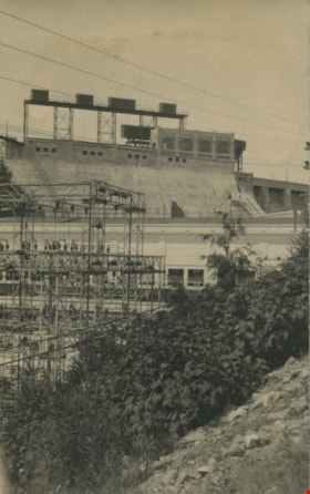
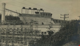
Adley Substation
https://search.heritageburnaby.ca/link/archivedescription34917
- Repository
- City of Burnaby Archives
- Date
- [1920] (date of original), copied 1986
- Collection/Fonds
- Burnaby Historical Society fonds
- Description Level
- Item
- Physical Description
- 1 photograph : b&w ; 8.8 x 12.5 cm print
- Scope and Content
- Photograph of the exterior of the Adley Substation, beside the Great Northern Railway tracks near Willingdon Avenue. Signs on the building read: "Western Canada Power Co. Ltd." and "Use Stave Lake Power."
- Repository
- City of Burnaby Archives
- Date
- [1920] (date of original), copied 1986
- Collection/Fonds
- Burnaby Historical Society fonds
- Subseries
- Photographs subseries
- Physical Description
- 1 photograph : b&w ; 8.8 x 12.5 cm print
- Description Level
- Item
- Record No.
- 158-002
- Access Restriction
- No restrictions
- Reproduction Restriction
- No known restrictions
- Accession Number
- BHS1986-08
- Scope and Content
- Photograph of the exterior of the Adley Substation, beside the Great Northern Railway tracks near Willingdon Avenue. Signs on the building read: "Western Canada Power Co. Ltd." and "Use Stave Lake Power."
- Subjects
- Buildings - Industrial - Powerhouses
- Media Type
- Photograph
- Notes
- Title based on contents of photograph
- Geographic Access
- Willingdon Avenue
Images
![Adley Substation, [1920] (date of original), copied 1986 thumbnail](/media/hpo/_Data/_Archives_Images/_Unrestricted/126/158-002.jpg)
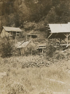
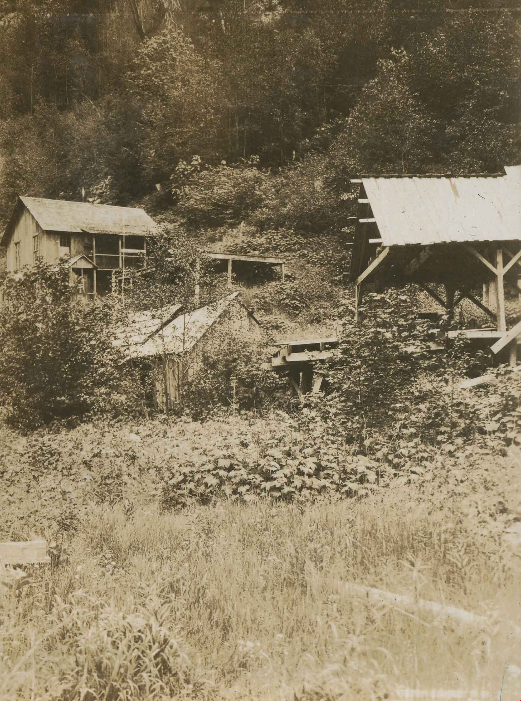
Dumbolten's on Siwash Creek
https://search.heritageburnaby.ca/link/archivedescription34370
- Repository
- City of Burnaby Archives
- Date
- 1925
- Collection/Fonds
- Burnaby Historical Society fonds
- Description Level
- Item
- Physical Description
- 1 photograph : b&w ; 7 x 9.5 cm on page 17.5 x 26.3 cm
- Scope and Content
- Photograph is identified by the caption as being "Dumbolten's on Siwash Creek" with a number of wooden buildings and structures built on the side of a hill. This photograph appears to have been taken by Arthur Peers, who travelled through the Fraser River Valley and worked on the construction of th…
- Repository
- City of Burnaby Archives
- Date
- 1925
- Collection/Fonds
- Burnaby Historical Society fonds
- Subseries
- Peers family subseries
- Physical Description
- 1 photograph : b&w ; 7 x 9.5 cm on page 17.5 x 26.3 cm
- Description Level
- Item
- Record No.
- 020-077
- Access Restriction
- No restrictions
- Reproduction Restriction
- No known restrictions
- Accession Number
- BHS2007-04
- Scope and Content
- Photograph is identified by the caption as being "Dumbolten's on Siwash Creek" with a number of wooden buildings and structures built on the side of a hill. This photograph appears to have been taken by Arthur Peers, who travelled through the Fraser River Valley and worked on the construction of the Trans-Provincial Highway during the later 1920s.
- Subjects
- Buildings - Industrial
- Media Type
- Photograph
- Photographer
- Peers, Arthur Francis "Mike"
- Notes
- Title based on caption accompanying photograph
Images
![Horne Payne Receiving Station, [1920] (date of original), copied 1986 thumbnail](/media/hpo/_Data/_Archives_Images/_Unrestricted/126/158-001.jpg?width=280)
Horne Payne Receiving Station
https://search.heritageburnaby.ca/link/archivedescription34916
- Repository
- City of Burnaby Archives
- Date
- [1920] (date of original), copied 1986
- Collection/Fonds
- Burnaby Historical Society fonds
- Description Level
- Item
- Physical Description
- 1 photograph : b&w ; 8.8 x 12.5 cm print
- Scope and Content
- Photograph of the exterior of the Horne Payne substation, Boundary Road.
- Repository
- City of Burnaby Archives
- Date
- [1920] (date of original), copied 1986
- Collection/Fonds
- Burnaby Historical Society fonds
- Subseries
- Photographs subseries
- Physical Description
- 1 photograph : b&w ; 8.8 x 12.5 cm print
- Description Level
- Item
- Record No.
- 158-001
- Access Restriction
- No restrictions
- Reproduction Restriction
- No known restrictions
- Accession Number
- BHS1986-08
- Scope and Content
- Photograph of the exterior of the Horne Payne substation, Boundary Road.
- Subjects
- Buildings - Industrial - Powerhouses
- Media Type
- Photograph
- Notes
- Caption at lower right of photograph: "Horne-Payne Receiving Station"
- Geographic Access
- 2nd Avenue
- Street Address
- 3700 2nd Avenue
- Historic Neighbourhood
- Broadview (Historic Neighbourhood)
- Planning Study Area
- West Central Valley Area
Images
![Horne Payne Receiving Station, [1920] (date of original), copied 1986 thumbnail](/media/hpo/_Data/_Archives_Images/_Unrestricted/126/158-001.jpg)
![Nichols Chemical Co. Ltd. - D.D. Coolers Scrubbers and Settling Tanks with Pumps, [1928] thumbnail](/media/hpo/_Data/_BVM_Technical_Drawings/1998_0023_0016_002.jpg?width=280)
Nichols Chemical Co. Ltd. - D.D. Coolers Scrubbers and Settling Tanks with Pumps
https://search.heritageburnaby.ca/link/museumdescription11394
- Repository
- Burnaby Village Museum
- Date
- [1928]
- Collection/Fonds
- Nichols Chemical Company fonds
- Description Level
- Item
- Physical Description
- 1 technical drawing : blueprint ; 75.5 x 105 cm
- Scope and Content
- Item consists of technical drawing "D.D. Coolers Scrubbers and Settling Tanks with Pumps", "Nichols Chemical Co. LTD."; "Drawing No. 6314".
- Repository
- Burnaby Village Museum
- Collection/Fonds
- Nichols Chemical Company fonds
- Description Level
- Item
- Physical Description
- 1 technical drawing : blueprint ; 75.5 x 105 cm
- Material Details
- Scale 1:.25
- Scope and Content
- Item consists of technical drawing "D.D. Coolers Scrubbers and Settling Tanks with Pumps", "Nichols Chemical Co. LTD."; "Drawing No. 6314".
- Subjects
- Buildings - Industrial - Factories
- Responsibility
- General Chemical Company
- Geographic Access
- Barnet Road
- Street Address
- 8655 Barnet Road
- Accession Code
- BV998.23.16
- Access Restriction
- No restrictions
- Reproduction Restriction
- No known restrictions
- Date
- [1928]
- Media Type
- Technical Drawing
- Historic Neighbourhood
- Barnet (Historic Neighbourhood)
- Planning Study Area
- Burnaby Mountain Area
- Scan Resolution
- 300
- Scan Date
- 2022-05-10
- Notes
- Title based on contents of item
- "Scale 1/4" = 1'
- Stamp in lower left corner reads: "Private Design", "This Property Exclusively of General Chemical Company"
- Stamp on lower right reads: "Jul 12, 1946"
Images
![Nichols Chemical Co. Ltd. - D.D. Coolers Scrubbers and Settling Tanks with Pumps, [1928] thumbnail](/media/hpo/_Data/_BVM_Technical_Drawings/1998_0023_0016_002.jpg)
![Nichols Chemical Co. Ltd. - Drawing No. 6312, [1928] thumbnail](/media/hpo/_Data/_BVM_Technical_Drawings/1998_0023_0010_002.jpg?width=280)
Nichols Chemical Co. Ltd. - Drawing No. 6312
https://search.heritageburnaby.ca/link/museumdescription11388
- Repository
- Burnaby Village Museum
- Date
- [1928]
- Collection/Fonds
- Nichols Chemical Company fonds
- Description Level
- Item
- Physical Description
- 1 technical drawing : blueprint ; 73.5 x 104.5 cm
- Scope and Content
- Item consists of technical "Drawing No. 6312" "Nichols Chemical Co. Ltd.".
- Repository
- Burnaby Village Museum
- Collection/Fonds
- Nichols Chemical Company fonds
- Description Level
- Item
- Physical Description
- 1 technical drawing : blueprint ; 73.5 x 104.5 cm
- Material Details
- Scale 1:.25
- Scope and Content
- Item consists of technical "Drawing No. 6312" "Nichols Chemical Co. Ltd.".
- Subjects
- Buildings - Industrial - Factories
- Responsibility
- General Chemical Company
- Geographic Access
- Barnet Road
- Street Address
- 8655 Barnet Road
- Accession Code
- BV998.23.10
- Access Restriction
- No restrictions
- Reproduction Restriction
- No known restrictions
- Date
- [1928]
- Media Type
- Technical Drawing
- Historic Neighbourhood
- Barnet (Historic Neighbourhood)
- Planning Study Area
- Burnaby Mountain Area
- Scan Resolution
- 300
- Scan Date
- 2022-05-10
- Notes
- Title based on contents of item
- Hand-stamped horizontally is "MAR 12 1946"
- Stamp on back reads: "Private Design", "The Property Exclusively of General Chemical Company"
- "Scale 1/4" = 1'
Images
![Nichols Chemical Co. Ltd. - Drawing No. 6312, [1928] thumbnail](/media/hpo/_Data/_BVM_Technical_Drawings/1998_0023_0010_002.jpg)
![Pacific Guano Plant, [1920] (date of original), copied 1991 thumbnail](/media/hpo/_Data/_Archives_Images/_Unrestricted/370/370-293.jpg?width=280)
Pacific Guano Plant
https://search.heritageburnaby.ca/link/archivedescription37705
- Repository
- City of Burnaby Archives
- Date
- [1920] (date of original), copied 1991
- Collection/Fonds
- Burnaby Historical Society fonds
- Description Level
- Item
- Physical Description
- 1 photograph : b&w ; 3.1 x 3.9 cm print on contact sheet 20.2 x 25.3 cm
- Scope and Content
- Photograph of the Pacific Guano plant on Burrard Inlet at the foot of Burnaby Mountain. It was also used as chemical plant, processing guano. (Any excrement from birds, seals, or bats, with value to humans as fertilizer, may be referred to as guano).
- Repository
- City of Burnaby Archives
- Date
- [1920] (date of original), copied 1991
- Collection/Fonds
- Burnaby Historical Society fonds
- Subseries
- Burnaby Image Bank subseries
- Physical Description
- 1 photograph : b&w ; 3.1 x 3.9 cm print on contact sheet 20.2 x 25.3 cm
- Description Level
- Item
- Record No.
- 370-293
- Access Restriction
- No restrictions
- Reproduction Restriction
- No known restrictions
- Accession Number
- BHS1999-03
- Scope and Content
- Photograph of the Pacific Guano plant on Burrard Inlet at the foot of Burnaby Mountain. It was also used as chemical plant, processing guano. (Any excrement from birds, seals, or bats, with value to humans as fertilizer, may be referred to as guano).
- Subjects
- Buildings - Industrial
- Names
- Pacific Guano
- Media Type
- Photograph
- Notes
- Title based on contents of photograph
- 1 b&w copy negative accompanying
- Geographic Access
- Barnet Road
- Historic Neighbourhood
- Barnet (Historic Neighbourhood)
- Planning Study Area
- Burnaby Mountain Area
Images
![Pacific Guano Plant, [1920] (date of original), copied 1991 thumbnail](/media/hpo/_Data/_Archives_Images/_Unrestricted/370/370-293.jpg)
![Phillips Dairy Farm, [192-] (date of original), copied 1986 thumbnail](/media/hpo/_Data/_Archives_Images/_Unrestricted/204/204-519.jpg?width=280)
Phillips Dairy Farm
https://search.heritageburnaby.ca/link/archivedescription35661
- Repository
- City of Burnaby Archives
- Date
- [192-] (date of original), copied 1986
- Collection/Fonds
- Burnaby Historical Society fonds
- Description Level
- Item
- Physical Description
- 1 photograph : b&w ; 12.7 x 17.8 cm print
- Scope and Content
- Photograph of Phillips dairy farm at 515 Byrne Road (later renumbered 5670 Byrne Road). The dairy and barn are shown with Norman Phillips (son of John and Lily Phillips).
- Repository
- City of Burnaby Archives
- Date
- [192-] (date of original), copied 1986
- Collection/Fonds
- Burnaby Historical Society fonds
- Subseries
- Pioneer Tales subseries
- Physical Description
- 1 photograph : b&w ; 12.7 x 17.8 cm print
- Description Level
- Item
- Record No.
- 204-519
- Access Restriction
- No restrictions
- Reproduction Restriction
- No known restrictions
- Accession Number
- BHS1988-03
- Scope and Content
- Photograph of Phillips dairy farm at 515 Byrne Road (later renumbered 5670 Byrne Road). The dairy and barn are shown with Norman Phillips (son of John and Lily Phillips).
- Media Type
- Photograph
- Notes
- Title based on contents of photograph
- Geographic Access
- Byrne Road
- Street Address
- 5670 Byrne Road
- Historic Neighbourhood
- Fraser Arm (Historic Neighbourhood)
- Planning Study Area
- Big Bend Area
Images
![Phillips Dairy Farm, [192-] (date of original), copied 1986 thumbnail](/media/hpo/_Data/_Archives_Images/_Unrestricted/204/204-519.jpg)
Stave River Powerhouse
https://search.heritageburnaby.ca/link/archivedescription34441
- Repository
- City of Burnaby Archives
- Date
- 1929
- Collection/Fonds
- Burnaby Historical Society fonds
- Description Level
- Item
- Physical Description
- 1 photograph : b&w ; 6.5 x 10.4 cm on page 17.5 x 26.3 cm
- Scope and Content
- Photograph of the Stave River Powerhouse in Mission, BC.
- Repository
- City of Burnaby Archives
- Date
- 1929
- Collection/Fonds
- Burnaby Historical Society fonds
- Subseries
- Peers family subseries
- Physical Description
- 1 photograph : b&w ; 6.5 x 10.4 cm on page 17.5 x 26.3 cm
- Description Level
- Item
- Record No.
- 020-148
- Access Restriction
- No restrictions
- Reproduction Restriction
- No known restrictions
- Accession Number
- BHS2007-04
- Scope and Content
- Photograph of the Stave River Powerhouse in Mission, BC.
- Subjects
- Buildings - Industrial - Powerhouses
- Media Type
- Photograph
- Notes
- Title based on caption accompanying photograph
Images

Stave River Powerhouse
https://search.heritageburnaby.ca/link/archivedescription34442
- Repository
- City of Burnaby Archives
- Date
- 1929
- Collection/Fonds
- Burnaby Historical Society fonds
- Description Level
- Item
- Physical Description
- 1 photograph : b&w ; 7 x 12 cm on page 17.5 x 26.3 cm
- Scope and Content
- Photograph of the Stave River Powerhouse in Mission, BC.
- Repository
- City of Burnaby Archives
- Date
- 1929
- Collection/Fonds
- Burnaby Historical Society fonds
- Subseries
- Peers family subseries
- Physical Description
- 1 photograph : b&w ; 7 x 12 cm on page 17.5 x 26.3 cm
- Description Level
- Item
- Record No.
- 020-149
- Access Restriction
- No restrictions
- Reproduction Restriction
- No known restrictions
- Accession Number
- BHS2007-04
- Scope and Content
- Photograph of the Stave River Powerhouse in Mission, BC.
- Subjects
- Buildings - Industrial - Powerhouses
- Media Type
- Photograph
- Notes
- Title based on caption accompanying photograph
Images

![Wagner blacksmith shop, [before June 11, 1926] thumbnail](/media/hpo/_Data/_BVM_Images/1990/199200450055.jpg?width=280)
Wagner blacksmith shop
https://search.heritageburnaby.ca/link/museumdescription1164
- Repository
- Burnaby Village Museum
- Date
- [before June 11, 1926]
- Collection/Fonds
- Burnaby Village Museum Photograph collection
- Description Level
- Item
- Physical Description
- 1 photograph : b&w ; 6 x 10.5 cm
- Scope and Content
- Photograph of the Wagner blacksmith shop on Kingsway (across from the gate to Central Park). Three men are standing in the doorway below a sign reading "The Wagner Bumper Made Here, Auto springs repaired." The man on the left is holding a bumper in his hands. A car is parked on the right and on the…
- Repository
- Burnaby Village Museum
- Collection/Fonds
- Burnaby Village Museum Photograph collection
- Description Level
- Item
- Physical Description
- 1 photograph : b&w ; 6 x 10.5 cm
- Scope and Content
- Photograph of the Wagner blacksmith shop on Kingsway (across from the gate to Central Park). Three men are standing in the doorway below a sign reading "The Wagner Bumper Made Here, Auto springs repaired." The man on the left is holding a bumper in his hands. A car is parked on the right and on the left a sign that reads, "TRIPLE SPRING BUMPER, FOR SALE, MADE TO FIT ANY CAR."
- Geographic Access
- Kingsway
- Accession Code
- BV992.45.55
- Access Restriction
- No restrictions
- Date
- [before June 11, 1926]
- Media Type
- Photograph
- Historic Neighbourhood
- Central Park (Historic Neighbourhood)
- Planning Study Area
- Maywood Area
- Scan Resolution
- 600
- Scan Date
- 01-Jun-09
- Scale
- 100
- Notes
- Title based on contents of photograph
- 1 b&w enlarged copy print accompanying
- Postal impression on recto of photograph reads: "Jun. 11/26 Burnaby"
- Note in blue ink on verso of photograph reads: "The new Shop / And our little Hall"
Images
![Wagner blacksmith shop, [before June 11, 1926] thumbnail](/media/hpo/_Data/_BVM_Images/1990/199200450055.jpg)
![Woodworking Plant, [192-] (date of original), copied 1986 thumbnail](/media/hpo/_Data/_Archives_Images/_Unrestricted/204/204-106.jpg?width=280)
Woodworking Plant
https://search.heritageburnaby.ca/link/archivedescription35249
- Repository
- City of Burnaby Archives
- Date
- [192-] (date of original), copied 1986
- Collection/Fonds
- Burnaby Historical Society fonds
- Description Level
- Item
- Physical Description
- 1 photograph : b&w ; 12.7 x 17.8 cm print
- Scope and Content
- Photograph of James Brookes Woodworking Plant located at 7730 6th Street. This site has also served as Cliff's Can Factory and Western Canadian Can Factory. Note the spur street car line (no. 2) where B.C. Electric Railway freight cars could load and unload.
- Repository
- City of Burnaby Archives
- Date
- [192-] (date of original), copied 1986
- Collection/Fonds
- Burnaby Historical Society fonds
- Subseries
- Pioneer Tales subseries
- Physical Description
- 1 photograph : b&w ; 12.7 x 17.8 cm print
- Description Level
- Item
- Record No.
- 204-106
- Access Restriction
- No restrictions
- Reproduction Restriction
- No known restrictions
- Accession Number
- BHS1988-03
- Scope and Content
- Photograph of James Brookes Woodworking Plant located at 7730 6th Street. This site has also served as Cliff's Can Factory and Western Canadian Can Factory. Note the spur street car line (no. 2) where B.C. Electric Railway freight cars could load and unload.
- Subjects
- Buildings - Industrial - Factories
- Media Type
- Photograph
- Notes
- Title based on contents of photograph
- Geographic Access
- 6th Street
- Street Address
- 7730 6th Street
- Historic Neighbourhood
- East Burnaby (Historic Neighbourhood)
- Planning Study Area
- Second Street Area
Images
![Woodworking Plant, [192-] (date of original), copied 1986 thumbnail](/media/hpo/_Data/_Archives_Images/_Unrestricted/204/204-106.jpg)
![Woodworking Plant, [192-] (date of original), copied 1986 thumbnail](/media/hpo/_Data/_Archives_Images/_Unrestricted/204/204-107.jpg?width=280)
Woodworking Plant
https://search.heritageburnaby.ca/link/archivedescription35250
- Repository
- City of Burnaby Archives
- Date
- [192-] (date of original), copied 1986
- Collection/Fonds
- Burnaby Historical Society fonds
- Description Level
- Item
- Physical Description
- 1 photograph : b&w ; 12.7 x 17.8 cm print
- Scope and Content
- Photograph of James Brookes Woodworking Plant, located at 7730 6th Street, taken from 13th Avenue. This site has also served as Cliff's Can Factory and Western Canadian Can Factory.
- Repository
- City of Burnaby Archives
- Date
- [192-] (date of original), copied 1986
- Collection/Fonds
- Burnaby Historical Society fonds
- Subseries
- Pioneer Tales subseries
- Physical Description
- 1 photograph : b&w ; 12.7 x 17.8 cm print
- Description Level
- Item
- Record No.
- 204-107
- Access Restriction
- No restrictions
- Reproduction Restriction
- No known restrictions
- Accession Number
- BHS1988-03
- Scope and Content
- Photograph of James Brookes Woodworking Plant, located at 7730 6th Street, taken from 13th Avenue. This site has also served as Cliff's Can Factory and Western Canadian Can Factory.
- Subjects
- Buildings - Industrial - Factories
- Media Type
- Photograph
- Notes
- Title based on contents of photograph
- Geographic Access
- 6th Street
- Street Address
- 7730 6th Street
- Historic Neighbourhood
- East Burnaby (Historic Neighbourhood)
- Planning Study Area
- Second Street Area
Images
![Woodworking Plant, [192-] (date of original), copied 1986 thumbnail](/media/hpo/_Data/_Archives_Images/_Unrestricted/204/204-107.jpg)
![Woodworking Plant, [192-] (date of original), copied 1986 thumbnail](/media/hpo/_Data/_Archives_Images/_Unrestricted/204/204-108.jpg?width=280)
Woodworking Plant
https://search.heritageburnaby.ca/link/archivedescription35251
- Repository
- City of Burnaby Archives
- Date
- [192-] (date of original), copied 1986
- Collection/Fonds
- Burnaby Historical Society fonds
- Description Level
- Item
- Physical Description
- 1 photograph : b&w ; 12.7 x 17.8 cm print
- Scope and Content
- Photograph of James Brookes Woodworking Plant, located at 7730 6th Street, taken from 6th Street. It was an East Burnaby landmark, established in 1902 as a can company by Edwin Cliff. This site has also served as Cliff's Can Factory and Western Canadian Can Factory.
- Repository
- City of Burnaby Archives
- Date
- [192-] (date of original), copied 1986
- Collection/Fonds
- Burnaby Historical Society fonds
- Subseries
- Pioneer Tales subseries
- Physical Description
- 1 photograph : b&w ; 12.7 x 17.8 cm print
- Description Level
- Item
- Record No.
- 204-108
- Access Restriction
- No restrictions
- Reproduction Restriction
- No known restrictions
- Accession Number
- BHS1988-03
- Scope and Content
- Photograph of James Brookes Woodworking Plant, located at 7730 6th Street, taken from 6th Street. It was an East Burnaby landmark, established in 1902 as a can company by Edwin Cliff. This site has also served as Cliff's Can Factory and Western Canadian Can Factory.
- Subjects
- Buildings - Industrial - Factories
- Media Type
- Photograph
- Notes
- Title based on contents of photograph
- Geographic Access
- 6th Street
- Street Address
- 7730 6th Street
- Historic Neighbourhood
- East Burnaby (Historic Neighbourhood)
- Planning Study Area
- Second Street Area
Images
![Woodworking Plant, [192-] (date of original), copied 1986 thumbnail](/media/hpo/_Data/_Archives_Images/_Unrestricted/204/204-108.jpg)
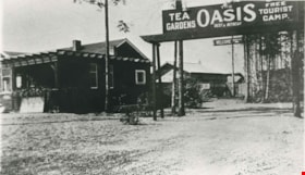
Oasis Tea Garden and Tourist Camp
https://search.heritageburnaby.ca/link/archivedescription35623
- Repository
- City of Burnaby Archives
- Date
- 1925 (date of original), copied 1986
- Collection/Fonds
- Burnaby Historical Society fonds
- Description Level
- Item
- Physical Description
- 1 photograph : b&w ; 12.7 x 17.8 cm print
- Scope and Content
- Photograph of the Oasis tea garden and tourist camp at 2675 Kingsway (Pacific Highway). It was later renumbered 6105 Kingsway. Guests could pitch tents for free at the campground and patronize the tea garden. The complex was operated by the Raymer family.
- Repository
- City of Burnaby Archives
- Date
- 1925 (date of original), copied 1986
- Collection/Fonds
- Burnaby Historical Society fonds
- Subseries
- Pioneer Tales subseries
- Physical Description
- 1 photograph : b&w ; 12.7 x 17.8 cm print
- Description Level
- Item
- Record No.
- 204-481
- Access Restriction
- No restrictions
- Reproduction Restriction
- No known restrictions
- Accession Number
- BHS1988-03
- Scope and Content
- Photograph of the Oasis tea garden and tourist camp at 2675 Kingsway (Pacific Highway). It was later renumbered 6105 Kingsway. Guests could pitch tents for free at the campground and patronize the tea garden. The complex was operated by the Raymer family.
- Names
- Oasis
- Media Type
- Photograph
- Notes
- Title based on contents of photograph
- Geographic Access
- Kingsway
- Street Address
- 6105 Kingsway
- Planning Study Area
- Windsor Area
Images

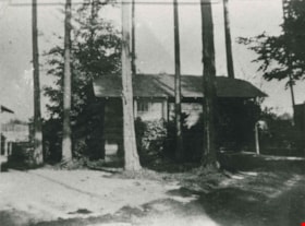
Oasis Tourist Camp cabins
https://search.heritageburnaby.ca/link/archivedescription35627
- Repository
- City of Burnaby Archives
- Date
- 1929 (date of original), copied 1986
- Collection/Fonds
- Burnaby Historical Society fonds
- Description Level
- Item
- Physical Description
- 1 photograph : b&w ; 12.7 x 17.8 cm print
- Scope and Content
- Photograph of the first of ten rental cabins built at The Oasis tourist camp. The Oasis was located at 2675 Kingsway (Pacific Highway). It was later renumbered 6105 Kingsway.
- Repository
- City of Burnaby Archives
- Date
- 1929 (date of original), copied 1986
- Collection/Fonds
- Burnaby Historical Society fonds
- Subseries
- Pioneer Tales subseries
- Physical Description
- 1 photograph : b&w ; 12.7 x 17.8 cm print
- Description Level
- Item
- Record No.
- 204-485
- Access Restriction
- No restrictions
- Reproduction Restriction
- No known restrictions
- Accession Number
- BHS1988-03
- Scope and Content
- Photograph of the first of ten rental cabins built at The Oasis tourist camp. The Oasis was located at 2675 Kingsway (Pacific Highway). It was later renumbered 6105 Kingsway.
- Names
- Oasis
- Media Type
- Photograph
- Notes
- Title based on contents of photograph
- Geographic Access
- Kingsway
- Street Address
- 6105 Kingsway
- Planning Study Area
- Windsor Area
Images
![Old Hudson's Bay Fort, Nanaimo, [1920] thumbnail](/media/hpo/_Data/_Archives_Images/_Unrestricted/477/477-552.jpg?width=280)
Old Hudson's Bay Fort, Nanaimo
https://search.heritageburnaby.ca/link/archivedescription39233
- Repository
- City of Burnaby Archives
- Date
- [1920]
- Collection/Fonds
- Peers Family and Hill Family fonds
- Description Level
- Item
- Physical Description
- 1 photograph : b&w ; 6.2 x 10.5 cm on page 24.5 x 32.5 cm (pasted in album)
- Scope and Content
- Photograph of the Nanaimo Bastion, the original Hudson's Bay fort built in 1853.
- Repository
- City of Burnaby Archives
- Date
- [1920]
- Collection/Fonds
- Peers Family and Hill Family fonds
- Physical Description
- 1 photograph : b&w ; 6.2 x 10.5 cm on page 24.5 x 32.5 cm (pasted in album)
- Description Level
- Item
- Record No.
- 477-552
- Access Restriction
- No restrictions
- Reproduction Restriction
- No known restrictions
- Accession Number
- 2007-12
- Scope and Content
- Photograph of the Nanaimo Bastion, the original Hudson's Bay fort built in 1853.
- Media Type
- Photograph
- Notes
- Title based on caption accompanying photograph
Images
![Old Hudson's Bay Fort, Nanaimo, [1920] thumbnail](/media/hpo/_Data/_Archives_Images/_Unrestricted/477/477-552.jpg)
![Steam donkey, [192-] (date of original), copied 1992 thumbnail](/media/hpo/_Data/_Archives_Images/_Unrestricted/315/315-459.jpg?width=280)
Steam donkey
https://search.heritageburnaby.ca/link/archivedescription37001
- Repository
- City of Burnaby Archives
- Date
- [192-] (date of original), copied 1992
- Collection/Fonds
- Burnaby Historical Society fonds
- Description Level
- Item
- Physical Description
- 1 photograph : b&w ; 6.1 x 8.9 cm print
- Scope and Content
- Photograph of a donkey engine used for logging (also known as a steam donkey). William "Bill" Price operated one of these on Vancouver Island near Nanaimo.
- Repository
- City of Burnaby Archives
- Date
- [192-] (date of original), copied 1992
- Collection/Fonds
- Burnaby Historical Society fonds
- Subseries
- Burnaby Centennial Anthology subseries
- Physical Description
- 1 photograph : b&w ; 6.1 x 8.9 cm print
- Description Level
- Item
- Record No.
- 315-459
- Access Restriction
- No restrictions
- Reproduction Restriction
- No known restrictions
- Accession Number
- BHS1994-04
- Scope and Content
- Photograph of a donkey engine used for logging (also known as a steam donkey). William "Bill" Price operated one of these on Vancouver Island near Nanaimo.
- Media Type
- Photograph
- Notes
- Title based on contents of photograph
Images
![Steam donkey, [192-] (date of original), copied 1992 thumbnail](/media/hpo/_Data/_Archives_Images/_Unrestricted/315/315-459.jpg)
![Edmonds Coal and Wood truck, [192-] thumbnail](/media/hpo/_Data/_Archives_Images/_Unrestricted/204/204-686.jpg?width=280)
Edmonds Coal and Wood truck
https://search.heritageburnaby.ca/link/archivedescription35827
- Repository
- City of Burnaby Archives
- Date
- [192-]
- Collection/Fonds
- Burnaby Historical Society fonds
- Description Level
- Item
- Physical Description
- 1 photograph : b&w ; 12.7 x 17.8 cm print
- Scope and Content
- Photograph of Murdoch McMurray with a fuel truck. He bought into Edmonds Coal and Wood, 1500 Edmonds Street (later renumbered 7260 Edmonds Street).
- Repository
- City of Burnaby Archives
- Date
- [192-]
- Collection/Fonds
- Burnaby Historical Society fonds
- Subseries
- Pioneer Tales subseries
- Physical Description
- 1 photograph : b&w ; 12.7 x 17.8 cm print
- Description Level
- Item
- Record No.
- 204-686
- Access Restriction
- No restrictions
- Reproduction Restriction
- No known restrictions
- Accession Number
- BHS1988-03
- Scope and Content
- Photograph of Murdoch McMurray with a fuel truck. He bought into Edmonds Coal and Wood, 1500 Edmonds Street (later renumbered 7260 Edmonds Street).
- Media Type
- Photograph
- Notes
- Title based on contents of photograph
- Geographic Access
- Edmonds Street
- Street Address
- 7260 Edmonds Street
- Historic Neighbourhood
- Edmonds (Historic Neighbourhood)
- Planning Study Area
- Stride Avenue Area
Images
![Edmonds Coal and Wood truck, [192-] thumbnail](/media/hpo/_Data/_Archives_Images/_Unrestricted/204/204-686.jpg)
![Edmonds Coal and Wood truck, [192-] (date of original), copied 1986 thumbnail](/media/hpo/_Data/_Archives_Images/_Unrestricted/204/204-687.jpg?width=280)
Edmonds Coal and Wood truck
https://search.heritageburnaby.ca/link/archivedescription35828
- Repository
- City of Burnaby Archives
- Date
- [192-] (date of original), copied 1986
- Collection/Fonds
- Burnaby Historical Society fonds
- Description Level
- Item
- Physical Description
- 1 photograph : b&w ; 12.7 x 17.8 cm print
- Scope and Content
- Photograph of (left to right) Jack McMurray (older brother and partner in Edmonds Coal and Wood), Murdoch McMurray with baby son, Bob, and Emerson Doran (business partner). The truck is decorated, possibly for a May Day parade.
- Repository
- City of Burnaby Archives
- Date
- [192-] (date of original), copied 1986
- Collection/Fonds
- Burnaby Historical Society fonds
- Subseries
- Pioneer Tales subseries
- Physical Description
- 1 photograph : b&w ; 12.7 x 17.8 cm print
- Description Level
- Item
- Record No.
- 204-687
- Access Restriction
- No restrictions
- Reproduction Restriction
- No known restrictions
- Accession Number
- BHS1988-03
- Scope and Content
- Photograph of (left to right) Jack McMurray (older brother and partner in Edmonds Coal and Wood), Murdoch McMurray with baby son, Bob, and Emerson Doran (business partner). The truck is decorated, possibly for a May Day parade.
- Media Type
- Photograph
- Notes
- Title based on contents of photograph
Images
![Edmonds Coal and Wood truck, [192-] (date of original), copied 1986 thumbnail](/media/hpo/_Data/_Archives_Images/_Unrestricted/204/204-687.jpg)
![Emerson Doran and Murdoch McMurray delivering cordwood, [1925] (date of original), copied 1976 thumbnail](/media/hpo/_Data/_BVM_Images//1976/1976_0041_0001_001.jpg?width=280)
Emerson Doran and Murdoch McMurray delivering cordwood
https://search.heritageburnaby.ca/link/museumdescription711
- Repository
- Burnaby Village Museum
- Date
- [1925] (date of original), copied 1976
- Collection/Fonds
- Burnaby Village Museum Photograph collection
- Description Level
- Item
- Physical Description
- 1 photograph : b&w ; 20.2 x 25.3 cm print
- Scope and Content
- Photograph of two men in work clothes and hats leaning against a truck loaded with bundled fire wood. An accompanying note identifies the photograph as: Emerson Doran and Murdoch McMurray who owned Edmonds Wood and Coal Yard situated at Kingsway and Edmonds. They are standing beside their TRAFFIC …
- Repository
- Burnaby Village Museum
- Collection/Fonds
- Burnaby Village Museum Photograph collection
- Description Level
- Item
- Physical Description
- 1 photograph : b&w ; 20.2 x 25.3 cm print
- Scope and Content
- Photograph of two men in work clothes and hats leaning against a truck loaded with bundled fire wood. An accompanying note identifies the photograph as: Emerson Doran and Murdoch McMurray who owned Edmonds Wood and Coal Yard situated at Kingsway and Edmonds. They are standing beside their TRAFFIC truck which is loaded with cordwood about to be hauled from the Capitol Hill School grounds to the Edmonds Street School for use in heating the school. Edmonds Wood Yard had a contract with the Burnaby schools at this time to supply cordwood.
- Geographic Access
- Holdom Avenue
- Street Address
- 350 Holdom Avenue
- Accession Code
- HV976.41.1
- Access Restriction
- No restrictions
- Reproduction Restriction
- May be restricted by third party rights
- Date
- [1925] (date of original), copied 1976
- Media Type
- Photograph
- Historic Neighbourhood
- Capitol Hill (Historic Neighbourhood)
- Planning Study Area
- Capitol Hill Area
- Scan Resolution
- 600
- Scan Date
- 2023-06-13
- Notes
- Title based on contents of photograph
Images
![Emerson Doran and Murdoch McMurray delivering cordwood, [1925] (date of original), copied 1976 thumbnail](/media/hpo/_Data/_BVM_Images//1976/1976_0041_0001_001.jpg)