More like '7818 6th Street'
Narrow Results By
Subject
- Accidents - Automobile Accidents 2
- Accidents - Train Accidents 1
- Advertising Medium - Signs and Signboards 11
- Aerial Photographs 1
- Agricultural Tools and Equipment 1
- Agricultural Tools and Equipment - Plows 1
- Agriculture 1
- Agriculture - Crops 2
- Agriculture - Farms 10
- Agriculture - Fruit and Berries 1
- Agriculture - Poultry 3
- Animals - Cats 2

Frank Warburton
https://search.heritageburnaby.ca/link/archivedescription35915
- Repository
- City of Burnaby Archives
- Date
- 1928 (date of original), copied 1986
- Collection/Fonds
- Burnaby Historical Society fonds
- Description Level
- Item
- Physical Description
- 1 photograph : b&w ; 12.7 x 17.8 cm print
- Scope and Content
- Photograph of Frank Warburton painting white lines along Kingsway.
- Repository
- City of Burnaby Archives
- Date
- 1928 (date of original), copied 1986
- Collection/Fonds
- Burnaby Historical Society fonds
- Subseries
- Pioneer Tales subseries
- Physical Description
- 1 photograph : b&w ; 12.7 x 17.8 cm print
- Description Level
- Item
- Record No.
- 204-774
- Access Restriction
- No restrictions
- Reproduction Restriction
- No known restrictions
- Accession Number
- BHS1988-03
- Scope and Content
- Photograph of Frank Warburton painting white lines along Kingsway.
- Names
- Warburton, Frank
- Media Type
- Photograph
- Notes
- Title based on contents of photograph
- Geographic Access
- Kingsway
Images


Kingsway
https://search.heritageburnaby.ca/link/archivedescription34511
- Repository
- City of Burnaby Archives
- Date
- 1920
- Collection/Fonds
- Burnaby Historical Society fonds
- Description Level
- Item
- Physical Description
- 1 photograph : sepia ; 12.6 x 17.6 cm
- Scope and Content
- Photograph of Kingsway looking east at Boundary Road. A sign on the right reads, "Burnaby / Vehicles must slow down at all schools and intersections marked thus: X." A sign on a building at the left reads, "Arctic Ice Cream." Central Park is on the right.
- Repository
- City of Burnaby Archives
- Date
- 1920
- Collection/Fonds
- Burnaby Historical Society fonds
- Subseries
- Photographs subseries
- Physical Description
- 1 photograph : sepia ; 12.6 x 17.6 cm
- Description Level
- Item
- Record No.
- 031-002
- Access Restriction
- No restrictions
- Reproduction Restriction
- No known restrictions
- Accession Number
- BHS2007-04
- Scope and Content
- Photograph of Kingsway looking east at Boundary Road. A sign on the right reads, "Burnaby / Vehicles must slow down at all schools and intersections marked thus: X." A sign on a building at the left reads, "Arctic Ice Cream." Central Park is on the right.
- Subjects
- Geographic Features - Roads
- Advertising Medium - Signs and Signboards
- Transportation - Automobiles
- Media Type
- Photograph
- Notes
- Title based on contents of photograph
- Geographic Access
- Kingsway
- Central Park
- Boundary Road
- Historic Neighbourhood
- Central Park (Historic Neighbourhood)
- Planning Study Area
- Garden Village Area
- Maywood Area
Images


Painting Centre Line on Kingsway
https://search.heritageburnaby.ca/link/museumdescription65
- Repository
- Burnaby Village Museum
- Date
- 1928 (date of original), copied 1971
- Collection/Fonds
- Burnaby Village Museum Photograph collection
- Description Level
- Item
- Physical Description
- 1 photograph : b&w ; 15.0 x 25.2 cm print
- Scope and Content
- Photograph of Frank Warburton sitting backwards on a plank attached to the front of a car, as it is being driven. The make of the car is unidentified, but has wooden spoked wheels, running boards, and a soft convertible top. Mr. Warburton is painting the centre line on Kingsway. The photograph is…
- Repository
- Burnaby Village Museum
- Collection/Fonds
- Burnaby Village Museum Photograph collection
- Description Level
- Item
- Physical Description
- 1 photograph : b&w ; 15.0 x 25.2 cm print
- Scope and Content
- Photograph of Frank Warburton sitting backwards on a plank attached to the front of a car, as it is being driven. The make of the car is unidentified, but has wooden spoked wheels, running boards, and a soft convertible top. Mr. Warburton is painting the centre line on Kingsway. The photograph is taken 1928 at corner of Grimmer and Kingsway. In the background of the photograph, to the left, there are residential houses with a parked car, and to the right, is a tall gas pump.
- Names
- Warburton, Frank
- Geographic Access
- Kingsway
- Grimmer Street
- Accession Code
- HV971.173.1
- Access Restriction
- No restrictions
- Reproduction Restriction
- No known restrictions
- Date
- 1928 (date of original), copied 1971
- Media Type
- Photograph
- Historic Neighbourhood
- Central Park (Historic Neighbourhood)
- Planning Study Area
- Windsor Area
- Scan Resolution
- 600
- Scan Date
- 2023-03-28
- Notes
- Title based on contents of photograph
- The information in scope and content taken from earlier catalgue record from 1976, and verified by various accession and donation paperworks
Images

![Alice and David Norman seated on front of automobile, [between 1925 and 1935] thumbnail](/media/hpo/_Data/_BVM_Images/2023/2023_0015_0006_001.jpg?width=280)
Alice and David Norman seated on front of automobile
https://search.heritageburnaby.ca/link/museumdescription20280
- Repository
- Burnaby Village Museum
- Date
- [between 1925 and 1935]
- Collection/Fonds
- Burnaby Village Museum Photograph collection
- Description Level
- Item
- Physical Description
- 1 photograph : b&w negative ; 12.5 x 10 cm
- Scope and Content
- Photograph of Alice Victoria (Goodridge) Norman and her husband David Augustus Norman seated on the front of a Model 'T" Ford motor automobile outside of the Goodridge grocery store on located at 4835 Hastings Street in Burnaby.
- Repository
- Burnaby Village Museum
- Collection/Fonds
- Burnaby Village Museum Photograph collection
- Description Level
- Item
- Physical Description
- 1 photograph : b&w negative ; 12.5 x 10 cm
- Scope and Content
- Photograph of Alice Victoria (Goodridge) Norman and her husband David Augustus Norman seated on the front of a Model 'T" Ford motor automobile outside of the Goodridge grocery store on located at 4835 Hastings Street in Burnaby.
- Subjects
- Buildings - Commercial
- Buildings - Commercial - Grocery Stores
- Transportation - Automobiles
- Accession Code
- BV023.15.6
- Access Restriction
- No restrictions
- Reproduction Restriction
- No known restrictions
- Date
- [between 1925 and 1935]
- Media Type
- Photograph
- Scan Resolution
- 3200
- Scan Date
- 2023-09-21
- Notes
- Title based on contents of photograph
- 1 b&w contact sheet accompanying
Images
![Alice and David Norman seated on front of automobile, [between 1925 and 1935] thumbnail](/media/hpo/_Data/_BVM_Images/2023/2023_0015_0006_001.jpg)
![Alice Norman and Bill Goodridge seated on front of automobile, [between 1925 and 1935] thumbnail](/media/hpo/_Data/_BVM_Images/2023/2023_0015_0005_001.jpg?width=280)
Alice Norman and Bill Goodridge seated on front of automobile
https://search.heritageburnaby.ca/link/museumdescription20279
- Repository
- Burnaby Village Museum
- Date
- [between 1925 and 1935]
- Collection/Fonds
- Burnaby Village Museum Photograph collection
- Description Level
- Item
- Physical Description
- 1 photograph : b&w negative ; 12.5 x 10 cm
- Scope and Content
- Photograph of Alice Victoria (Goodridge) Norman and her brother William "Bill" Goodridge seated on the front of a Model 'T" Ford motor automobile outside of the Goodridge grocery store located at 4835 Hastings Street in Burnaby.
- Repository
- Burnaby Village Museum
- Collection/Fonds
- Burnaby Village Museum Photograph collection
- Description Level
- Item
- Physical Description
- 1 photograph : b&w negative ; 12.5 x 10 cm
- Scope and Content
- Photograph of Alice Victoria (Goodridge) Norman and her brother William "Bill" Goodridge seated on the front of a Model 'T" Ford motor automobile outside of the Goodridge grocery store located at 4835 Hastings Street in Burnaby.
- Subjects
- Buildings - Commercial
- Buildings - Commercial - Grocery Stores
- Transportation - Automobiles
- Accession Code
- BV023.15.5
- Access Restriction
- No restrictions
- Reproduction Restriction
- No known restrictions
- Date
- [between 1925 and 1935]
- Media Type
- Photograph
- Scan Resolution
- 3200
- Scan Date
- 2023-09-21
- Notes
- Title based on contents of photograph
- 1 b&w contact sheet accompanying
Images
![Alice Norman and Bill Goodridge seated on front of automobile, [between 1925 and 1935] thumbnail](/media/hpo/_Data/_BVM_Images/2023/2023_0015_0005_001.jpg)
![Roads and sidewalks, [192-] (date of original), copied 1986 thumbnail](/media/hpo/_Data/_Archives_Images/_Unrestricted/204/204-037.jpg?width=280)
Roads and sidewalks
https://search.heritageburnaby.ca/link/archivedescription35180
- Repository
- City of Burnaby Archives
- Date
- [192-] (date of original), copied 1986
- Collection/Fonds
- Burnaby Historical Society fonds
- Description Level
- Item
- Physical Description
- 1 photograph : b&w ; 12.7 x 17.8 cm print
- Scope and Content
- Photograph of dirt roads and sidewalks in Burnaby in the 1920s. George Pearson supervised cement sidewalk building throughout Burnaby during the Great Depression. St. Helen's Roman Catholic Church may be in the background.
- Repository
- City of Burnaby Archives
- Date
- [192-] (date of original), copied 1986
- Collection/Fonds
- Burnaby Historical Society fonds
- Subseries
- Pioneer Tales subseries
- Physical Description
- 1 photograph : b&w ; 12.7 x 17.8 cm print
- Description Level
- Item
- Record No.
- 204-037
- Access Restriction
- No restrictions
- Reproduction Restriction
- No known restrictions
- Accession Number
- BHS1988-03
- Scope and Content
- Photograph of dirt roads and sidewalks in Burnaby in the 1920s. George Pearson supervised cement sidewalk building throughout Burnaby during the Great Depression. St. Helen's Roman Catholic Church may be in the background.
- Subjects
- Geographic Features - Sidewalks
- Geographic Features - Roads
- Buildings - Residential - Houses
- Media Type
- Photograph
- Notes
- Title based on contents of photograph
Images
![Roads and sidewalks, [192-] (date of original), copied 1986 thumbnail](/media/hpo/_Data/_Archives_Images/_Unrestricted/204/204-037.jpg)
![Royal Oak Garage, [1925] thumbnail](/media/hpo/_Data/_BVM_Images/1993/1993_0028_0036_001.jpg?width=280)
Royal Oak Garage
https://search.heritageburnaby.ca/link/museumdescription1253
- Repository
- Burnaby Village Museum
- Date
- [1925]
- Collection/Fonds
- Burnaby Village Museum Photograph collection
- Description Level
- Item
- Physical Description
- 1 photograph : b&w ; 19.5 x 24.5 cm
- Scope and Content
- Photograph of the Royal Oak Garage taken from a distance. A man is sitting in a tow truck in front of the garage, facing the camera. Three other cars are on site, including one which looks to be a 1925 Ford Runabout. Advertisements for "IMPERIAL PREMIER GASOLINE" and "SHELL GASOLINE" are visible. T…
- Repository
- Burnaby Village Museum
- Collection/Fonds
- Burnaby Village Museum Photograph collection
- Description Level
- Item
- Physical Description
- 1 photograph : b&w ; 19.5 x 24.5 cm
- Scope and Content
- Photograph of the Royal Oak Garage taken from a distance. A man is sitting in a tow truck in front of the garage, facing the camera. Three other cars are on site, including one which looks to be a 1925 Ford Runabout. Advertisements for "IMPERIAL PREMIER GASOLINE" and "SHELL GASOLINE" are visible. The Royal Oak Garage was located at 3439 Kingsway (later renumbered 5103 Kingsway).
- Subjects
- Buildings - Commercial - Service Stations
- Transportation - Automobiles
- Transportation - Trucks
- Names
- Royal Oak Garage
- Geographic Access
- Kingsway
- Street Address
- 5103 Kingsway
- Accession Code
- BV993.28.36
- Access Restriction
- No restrictions
- Reproduction Restriction
- No known restrictions
- Date
- [1925]
- Media Type
- Photograph
- Historic Neighbourhood
- Central Park (Historic Neighbourhood)
- Planning Study Area
- Marlborough Area
- Related Material
- For a copy print of this photograph, see BV993.28.33
- Scan Resolution
- 600
- Scan Date
- 2024-04-23
- Notes
- Title based on contents of photograph
- Note on verso of photograph reads: "JENNIFER CULLEN/ DIV 8/ THIS SHOP WAS OWNED BY JENNIFER'S/ GREAT GRANDFATHER CULLEN/ 5000 BLOCK KINGSWAY BURNABY"
Images
![Royal Oak Garage, [1925] thumbnail](/media/hpo/_Data/_BVM_Images/1993/1993_0028_0036_001.jpg)
![Royal Oak Garage, [1925] thumbnail](/media/hpo/_Data/_BVM_Images/1993/1993_0028_0035_001.jpg?width=280)
Royal Oak Garage
https://search.heritageburnaby.ca/link/museumdescription3178
- Repository
- Burnaby Village Museum
- Date
- [1925]
- Collection/Fonds
- Burnaby Village Museum Photograph collection
- Description Level
- Item
- Physical Description
- 1 photograph : b&w ; 19.5 x 24.5 cm
- Scope and Content
- Photograph of the Royal Oak Garage taken from a distance with a tow truck parked out front. There is a man (the driver) standing on the outside of the tow truck with one foot on the running board (another man is partially visible on the far side). Two mechanics (in overalls) are standing near the d…
- Repository
- Burnaby Village Museum
- Collection/Fonds
- Burnaby Village Museum Photograph collection
- Description Level
- Item
- Physical Description
- 1 photograph : b&w ; 19.5 x 24.5 cm
- Scope and Content
- Photograph of the Royal Oak Garage taken from a distance with a tow truck parked out front. There is a man (the driver) standing on the outside of the tow truck with one foot on the running board (another man is partially visible on the far side). Two mechanics (in overalls) are standing near the door of the garage. Three other cars are on site, including one which looks to be a 1925 Ford Runabout. Advertisements for "IMPERIAL PREMIER GASOLINE" and "SHELL GASOLINE" are visible. The Royal Oak Garage was located at 3439 Kingsway (later renumbered 5103 Kingsway).
- Subjects
- Buildings - Commercial - Service Stations
- Occupations - Mechanics
- Transportation - Automobiles
- Transportation - Trucks
- Names
- Royal Oak Garage
- Geographic Access
- Kingsway
- Street Address
- 5103 Kingsway
- Accession Code
- BV993.28.35
- Access Restriction
- No restrictions
- Reproduction Restriction
- No known restrictions
- Date
- [1925]
- Media Type
- Photograph
- Historic Neighbourhood
- Central Park (Historic Neighbourhood)
- Planning Study Area
- Marlborough Area
- Scan Resolution
- 600
- Scan Date
- 2024-04-23
- Notes
- Title based on contents of photograph
- 1 b&w copy negative accompanying
Images
![Royal Oak Garage, [1925] thumbnail](/media/hpo/_Data/_BVM_Images/1993/1993_0028_0035_001.jpg)

Road round 1st tunnel
https://search.heritageburnaby.ca/link/archivedescription34407
- Repository
- City of Burnaby Archives
- Date
- 1925
- Collection/Fonds
- Burnaby Historical Society fonds
- Description Level
- Item
- Physical Description
- 1 photograph : b&w ; 7 x 12.2 cm on page 17.5 x 26.5 cm
- Scope and Content
- Photographs taken in Yale, looking toward a tunnel cut through a rock face at the side of a mountain. A caption written under the photograph reads "road round [sic] 1st tunnel." This photograph appears to have been taken by Arthur Peers, who travelled through the Fraser River Valley and worked on …
- Repository
- City of Burnaby Archives
- Date
- 1925
- Collection/Fonds
- Burnaby Historical Society fonds
- Subseries
- Peers family subseries
- Physical Description
- 1 photograph : b&w ; 7 x 12.2 cm on page 17.5 x 26.5 cm
- Description Level
- Item
- Record No.
- 020-114
- Access Restriction
- No restrictions
- Reproduction Restriction
- No known restrictions
- Accession Number
- BHS2007-04
- Scope and Content
- Photographs taken in Yale, looking toward a tunnel cut through a rock face at the side of a mountain. A caption written under the photograph reads "road round [sic] 1st tunnel." This photograph appears to have been taken by Arthur Peers, who travelled through the Fraser River Valley and worked on the construction of the Trans-Provincial Highway during the later 1920s.
- Media Type
- Photograph
- Photographer
- Peers, Arthur Francis "Mike"
- Notes
- Title based on caption accompanying photograph
Images

![Mary Warren and Bill Anthony, [192-] (date of original), copied 1986 thumbnail](/media/hpo/_Data/_Archives_Images/_Unrestricted/204/204-404.jpg?width=280)
Mary Warren and Bill Anthony
https://search.heritageburnaby.ca/link/archivedescription35546
- Repository
- City of Burnaby Archives
- Date
- [192-] (date of original), copied 1986
- Collection/Fonds
- Burnaby Historical Society fonds
- Description Level
- Item
- Physical Description
- 1 photograph : b&w ; 12.7 x 17.8 cm print
- Scope and Content
- Photograph of Mary Warren and Bill Anthony, west of the Warren family home at 4264 Union Street. The street did not extend past the Warren house. A "corduroy" road was used in the early years: split cedar logs placed side by side.
- Repository
- City of Burnaby Archives
- Date
- [192-] (date of original), copied 1986
- Collection/Fonds
- Burnaby Historical Society fonds
- Subseries
- Pioneer Tales subseries
- Physical Description
- 1 photograph : b&w ; 12.7 x 17.8 cm print
- Description Level
- Item
- Record No.
- 204-404
- Access Restriction
- No restrictions
- Reproduction Restriction
- No known restrictions
- Accession Number
- BHS1988-03
- Scope and Content
- Photograph of Mary Warren and Bill Anthony, west of the Warren family home at 4264 Union Street. The street did not extend past the Warren house. A "corduroy" road was used in the early years: split cedar logs placed side by side.
- Media Type
- Photograph
- Notes
- Title based on contents of photograph
- Geographic Access
- Union Street
- Street Address
- 4264 Union Street
- Historic Neighbourhood
- Vancouver Heights (Historic Neighbourhood)
- Planning Study Area
- Willingdon Heights Area
Images
![Mary Warren and Bill Anthony, [192-] (date of original), copied 1986 thumbnail](/media/hpo/_Data/_Archives_Images/_Unrestricted/204/204-404.jpg)

Opening of the Hastings-Barnet Road
https://search.heritageburnaby.ca/link/archivedescription38660
- Repository
- City of Burnaby Archives
- Date
- 1927
- Collection/Fonds
- Burnaby Historical Society fonds
- Description Level
- Item
- Physical Description
- 1 photograph : sepia ; 17.5 x 26.5 cm
- Scope and Content
- Photograph of the official opening of the newly paved Hastings-Barnet Road which opened on Saturday December 10, 1927. In the foreground the Provincial Minister of Public Works Dr. W.H. Sutherland is opening a wooden gate, with a large crowd gathered around. The Barnet Lumber Company Ltd. building …
- Repository
- City of Burnaby Archives
- Date
- 1927
- Collection/Fonds
- Burnaby Historical Society fonds
- Subseries
- North Burnaby Board of Trade subseries
- Physical Description
- 1 photograph : sepia ; 17.5 x 26.5 cm
- Description Level
- Item
- Record No.
- 476-003
- Access Restriction
- No restrictions
- Reproduction Restriction
- No known restrictions
- Accession Number
- BHS2005-8
- Scope and Content
- Photograph of the official opening of the newly paved Hastings-Barnet Road which opened on Saturday December 10, 1927. In the foreground the Provincial Minister of Public Works Dr. W.H. Sutherland is opening a wooden gate, with a large crowd gathered around. The Barnet Lumber Company Ltd. building on Hastings Street is in the background.
- Subjects
- Geographic Features - Roads
- Persons - Crowds
- Buildings - Industrial - Mills
- Officials - Elected Officials
- Public Services - Public Works
- Names
- Barnet Mill
- Sutherland, W.H.
- Media Type
- Photograph
- Notes
- Title based on contents of photograph
- Geographic Access
- Hastings Street
- Street Address
- 3995 Hastings Street
- Historic Neighbourhood
- Vancouver Heights (Historic Neighbourhood)
- Planning Study Area
- Burnaby Heights Area
Images

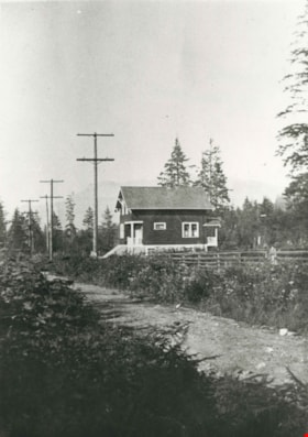
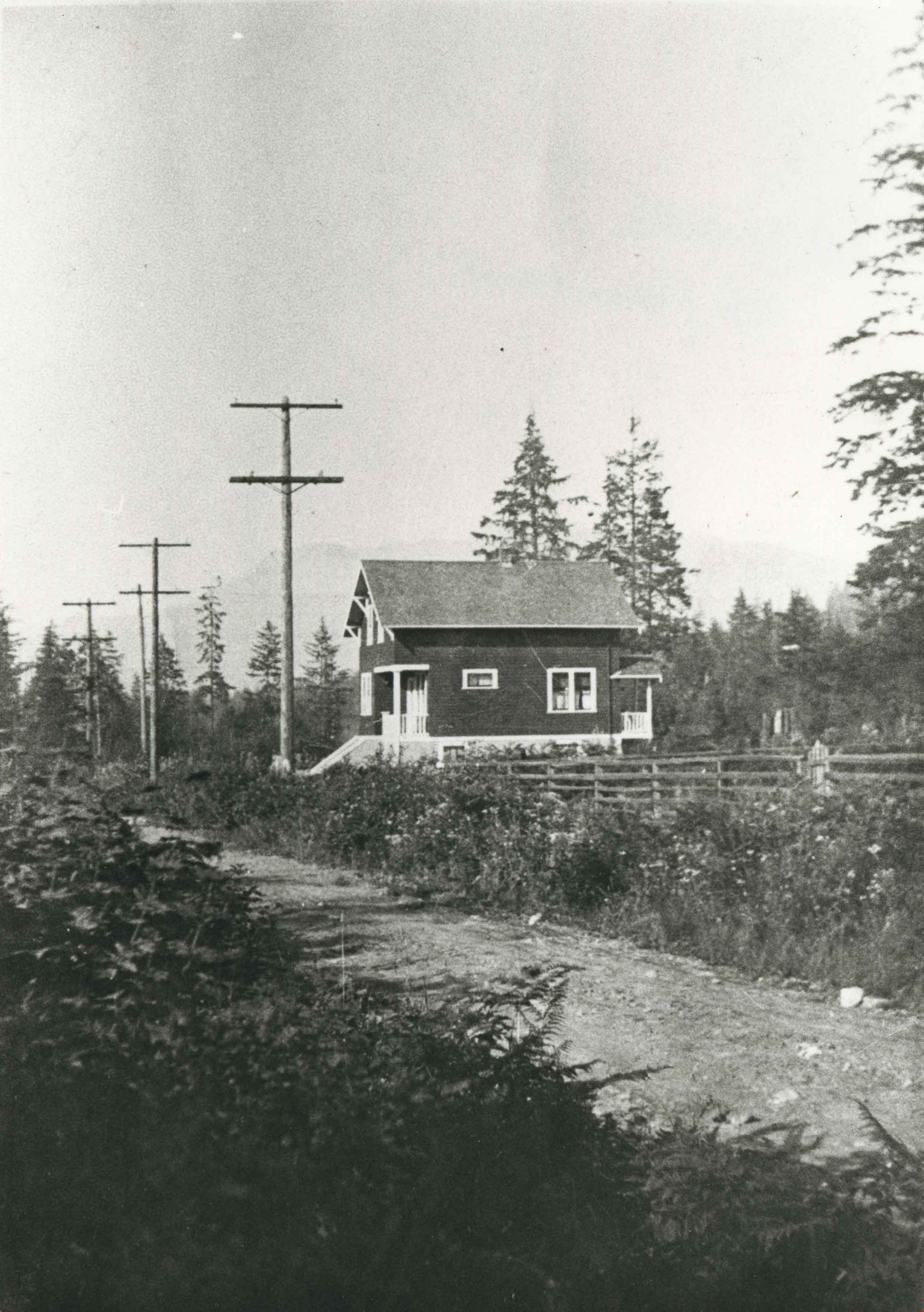
White family home
https://search.heritageburnaby.ca/link/archivedescription35176
- Repository
- City of Burnaby Archives
- Date
- 1920 (date of original), copied 1986
- Collection/Fonds
- Burnaby Historical Society fonds
- Description Level
- Item
- Physical Description
- 1 photograph : b&w ; 12.7 x 17.8 cm print
- Scope and Content
- Photograph of the White family home near the corner of Beta Avenue and Pender Street (506 Beta Avenue) in North Burnaby. The family moved their belongings here with wheelbarrows.
- Repository
- City of Burnaby Archives
- Date
- 1920 (date of original), copied 1986
- Collection/Fonds
- Burnaby Historical Society fonds
- Subseries
- Pioneer Tales subseries
- Physical Description
- 1 photograph : b&w ; 12.7 x 17.8 cm print
- Description Level
- Item
- Record No.
- 204-033
- Access Restriction
- No restrictions
- Reproduction Restriction
- No known restrictions
- Accession Number
- BHS1988-03
- Scope and Content
- Photograph of the White family home near the corner of Beta Avenue and Pender Street (506 Beta Avenue) in North Burnaby. The family moved their belongings here with wheelbarrows.
- Media Type
- Photograph
- Notes
- Title based on contents of photograph
- Geographic Access
- Beta Avenue
- Street Address
- 506 Beta Avenue
- Historic Neighbourhood
- Capitol Hill (Historic Neighbourhood)
- Planning Study Area
- Brentwood Area
Images
![Central Park Auto Tourist Grounds, Vancouver Canada, [1923] thumbnail](/media/hpo/_Data/_Archives_Images/_Unrestricted/371/449-007.jpg?width=280)
Central Park Auto Tourist Grounds, Vancouver Canada
https://search.heritageburnaby.ca/link/archivedescription38512
- Repository
- City of Burnaby Archives
- Date
- [1923]
- Collection/Fonds
- Burnaby Historical Society fonds
- Description Level
- Item
- Physical Description
- 1 photograph : sepia postcard ; 9 x 14 cm
- Scope and Content
- Photographic postcard of the Central Park auto tourist grounds. Two unidentified men can be seen standing in front of a car which is parked next to the campground building. In the background, a clothesline has been strung holding towels and blankets.
- Repository
- City of Burnaby Archives
- Date
- [1923]
- Collection/Fonds
- Burnaby Historical Society fonds
- Subseries
- Photographs subseries
- Physical Description
- 1 photograph : sepia postcard ; 9 x 14 cm
- Description Level
- Item
- Record No.
- 449-007
- Access Restriction
- No restrictions
- Reproduction Restriction
- No known restrictions
- Accession Number
- BHS2007-04
- Scope and Content
- Photographic postcard of the Central Park auto tourist grounds. Two unidentified men can be seen standing in front of a car which is parked next to the campground building. In the background, a clothesline has been strung holding towels and blankets.
- Subjects
- Buildings - Commercial - Hotels and Motels
- Geographic Features - Parks
- Documentary Artifacts - Postcards
- Recreational Activities - Camping
- Media Type
- Photograph
- Notes
- Title based on caption
- Geographic Access
- Central Park
- Imperial Street
- Street Address
- 3883 Imperial Street
- Historic Neighbourhood
- Central Park (Historic Neighbourhood)
- Planning Study Area
- Maywood Area
Images
![Central Park Auto Tourist Grounds, Vancouver Canada, [1923] thumbnail](/media/hpo/_Data/_Archives_Images/_Unrestricted/371/449-007.jpg)
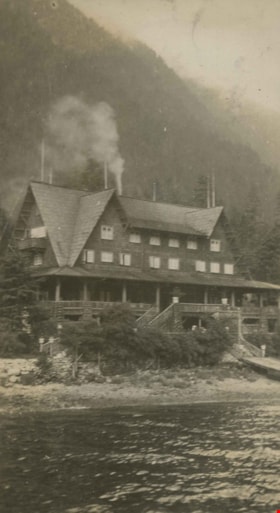
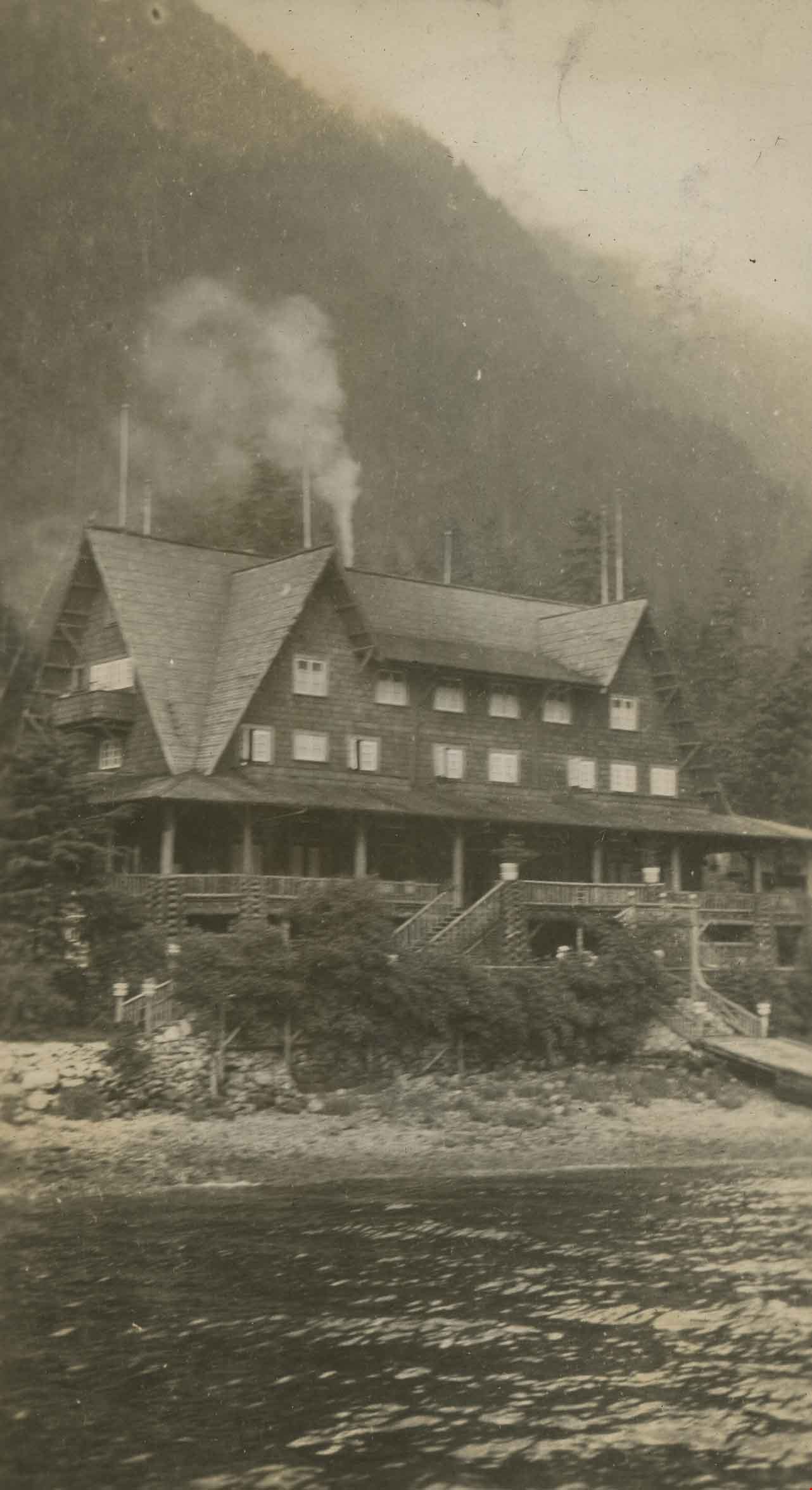
Wigwam Inn
https://search.heritageburnaby.ca/link/archivedescription39237
- Repository
- City of Burnaby Archives
- Date
- 1923
- Collection/Fonds
- Peers Family and Hill Family fonds
- Description Level
- Item
- Physical Description
- 1 photograph : b&w ; 5.5 x 10 cm on page 24.5 x 32.5 cm (pasted in album)
- Scope and Content
- Photograph of the Wigwam Inn, which is located at the northern end of Indian Arm of Burrard Inlet.
- Repository
- City of Burnaby Archives
- Date
- 1923
- Collection/Fonds
- Peers Family and Hill Family fonds
- Physical Description
- 1 photograph : b&w ; 5.5 x 10 cm on page 24.5 x 32.5 cm (pasted in album)
- Description Level
- Item
- Record No.
- 477-556
- Access Restriction
- No restrictions
- Reproduction Restriction
- No known restrictions
- Accession Number
- 2007-12
- Scope and Content
- Photograph of the Wigwam Inn, which is located at the northern end of Indian Arm of Burrard Inlet.
- Names
- Wigwam Inn
- Media Type
- Photograph
- Notes
- Title based on caption accompanying photograph
Images

Barnet Road
https://search.heritageburnaby.ca/link/archivedescription35634
- Repository
- City of Burnaby Archives
- Date
- 1922 (date of original), copied 1986
- Collection/Fonds
- Burnaby Historical Society fonds
- Description Level
- Item
- Physical Description
- 1 photograph : b&w ; 12.7 x 17.8 cm print
- Scope and Content
- Photograph of Robert Woolsey carrying his daughter, Margaret, piggy-back along Barnet Road. Note the planked surface. Margaret was two years old at the time. In the upper right corner of the photograph is the Barnet School caretaker's cottage, located beside Barnet School at 7820 Barnet Road.
- Repository
- City of Burnaby Archives
- Date
- 1922 (date of original), copied 1986
- Collection/Fonds
- Burnaby Historical Society fonds
- Subseries
- Pioneer Tales subseries
- Physical Description
- 1 photograph : b&w ; 12.7 x 17.8 cm print
- Description Level
- Item
- Record No.
- 204-492
- Access Restriction
- No restrictions
- Reproduction Restriction
- No known restrictions
- Accession Number
- BHS1988-03
- Scope and Content
- Photograph of Robert Woolsey carrying his daughter, Margaret, piggy-back along Barnet Road. Note the planked surface. Margaret was two years old at the time. In the upper right corner of the photograph is the Barnet School caretaker's cottage, located beside Barnet School at 7820 Barnet Road.
- Subjects
- Geographic Features - Roads
- Media Type
- Photograph
- Notes
- Title based on contents of photograph
- Geographic Access
- Barnet Road
- Street Address
- 7820 Barnet Road
- Historic Neighbourhood
- Barnet (Historic Neighbourhood)
- Planning Study Area
- Burnaby Mountain Area
Images


Barnet Road
https://search.heritageburnaby.ca/link/archivedescription35635
- Repository
- City of Burnaby Archives
- Date
- 1921 (date of original), copied 1986
- Collection/Fonds
- Burnaby Historical Society fonds
- Description Level
- Item
- Physical Description
- 1 photograph : b&w ; 12.7 x 17.8 cm print
- Scope and Content
- Photograph of Barnet Road covered with November snows. The road was always treacherous in winter with snow and rock slides. In the upper right corner of the photograph is Barnet School and caretaker's cottage. Barnet School was located at 7820 Barnet Road.
- Repository
- City of Burnaby Archives
- Date
- 1921 (date of original), copied 1986
- Collection/Fonds
- Burnaby Historical Society fonds
- Subseries
- Pioneer Tales subseries
- Physical Description
- 1 photograph : b&w ; 12.7 x 17.8 cm print
- Description Level
- Item
- Record No.
- 204-493
- Access Restriction
- No restrictions
- Reproduction Restriction
- No known restrictions
- Accession Number
- BHS1988-03
- Scope and Content
- Photograph of Barnet Road covered with November snows. The road was always treacherous in winter with snow and rock slides. In the upper right corner of the photograph is Barnet School and caretaker's cottage. Barnet School was located at 7820 Barnet Road.
- Names
- Barnet School
- Media Type
- Photograph
- Notes
- Title based on contents of photograph
- Geographic Access
- Barnet Road
- Street Address
- 7820 Barnet Road
- Historic Neighbourhood
- Barnet (Historic Neighbourhood)
- Planning Study Area
- Burnaby Mountain Area
Images


Bill Lewarne
https://search.heritageburnaby.ca/link/archivedescription35197
- Repository
- City of Burnaby Archives
- Date
- 1929 (date of original), copied 1986
- Collection/Fonds
- Burnaby Historical Society fonds
- Description Level
- Item
- Physical Description
- 1 photograph : b&w ; 12.7 x 17.8 cm print
- Scope and Content
- Photograph of young Bill (William) Lewarne in front of his grandparents' home, at Portland Street and McGregor Avenue. Bill Lewarne went on to become the Mayor of Burnaby, serving from 1981 to 1987. He also served as a member of Council from 1973 to 1975 and 1977 to 1981.
- Repository
- City of Burnaby Archives
- Date
- 1929 (date of original), copied 1986
- Collection/Fonds
- Burnaby Historical Society fonds
- Subseries
- Pioneer Tales subseries
- Physical Description
- 1 photograph : b&w ; 12.7 x 17.8 cm print
- Description Level
- Item
- Record No.
- 204-054
- Access Restriction
- No restrictions
- Reproduction Restriction
- No known restrictions
- Accession Number
- BHS1988-03
- Scope and Content
- Photograph of young Bill (William) Lewarne in front of his grandparents' home, at Portland Street and McGregor Avenue. Bill Lewarne went on to become the Mayor of Burnaby, serving from 1981 to 1987. He also served as a member of Council from 1973 to 1975 and 1977 to 1981.
- Media Type
- Photograph
- Notes
- Title based on contents of photograph
Images


Government Road
https://search.heritageburnaby.ca/link/archivedescription35569
- Repository
- City of Burnaby Archives
- Date
- 1925 (date of original), copied 1986
- Collection/Fonds
- Burnaby Historical Society fonds
- Description Level
- Item
- Physical Description
- 1 photograph : b&w ; 12.7 x 17.8 cm print
- Scope and Content
- Photograph of Government Road in front of the Haddon family house at 7870 Government Road. Note the bushland and rough road surface.
- Repository
- City of Burnaby Archives
- Date
- 1925 (date of original), copied 1986
- Collection/Fonds
- Burnaby Historical Society fonds
- Subseries
- Pioneer Tales subseries
- Physical Description
- 1 photograph : b&w ; 12.7 x 17.8 cm print
- Description Level
- Item
- Record No.
- 204-427
- Access Restriction
- No restrictions
- Reproduction Restriction
- No known restrictions
- Accession Number
- BHS1988-03
- Scope and Content
- Photograph of Government Road in front of the Haddon family house at 7870 Government Road. Note the bushland and rough road surface.
- Subjects
- Geographic Features - Roads
- Media Type
- Photograph
- Notes
- Title based on contents of photograph
- Geographic Access
- Government Road
- Historic Neighbourhood
- Lozells (Historic Neighbourhood)
- Planning Study Area
- Government Road Area
Images


The Green Timbers
https://search.heritageburnaby.ca/link/archivedescription34299
- Repository
- City of Burnaby Archives
- Date
- 1923
- Collection/Fonds
- Burnaby Historical Society fonds
- Description Level
- Item
- Physical Description
- 1 photograph : b&w ; 12.2 x 7.5 cm on page 23.5 x 17.5 cm
- Scope and Content
- Photograph taken looking down a tree-lined road, and is labelled "The Green Timbers". An automobile is parked along the side of the road. The Green Timbers was a famous roadway that went through Surrey and by the 1920s it was known as the only remaining stretch of virgin forest all the way from Ca…
- Repository
- City of Burnaby Archives
- Date
- 1923
- Collection/Fonds
- Burnaby Historical Society fonds
- Subseries
- Peers family subseries
- Physical Description
- 1 photograph : b&w ; 12.2 x 7.5 cm on page 23.5 x 17.5 cm
- Description Level
- Item
- Record No.
- 020-006
- Access Restriction
- No restrictions
- Reproduction Restriction
- No known restrictions
- Accession Number
- BHS2007-04
- Scope and Content
- Photograph taken looking down a tree-lined road, and is labelled "The Green Timbers". An automobile is parked along the side of the road. The Green Timbers was a famous roadway that went through Surrey and by the 1920s it was known as the only remaining stretch of virgin forest all the way from California to British Columbia. In more recent years, this area in Surrey has been declared an urban forest park.
- Media Type
- Photograph
- Notes
- Title based on caption accompanying photograph
Images


The Green Timbers
https://search.heritageburnaby.ca/link/archivedescription34300
- Repository
- City of Burnaby Archives
- Date
- 1923
- Collection/Fonds
- Burnaby Historical Society fonds
- Description Level
- Item
- Physical Description
- 1 photograph : b&w ; 12.2 x 7.5 cm on page 23.5 x 17.5 cm
- Scope and Content
- Photograph is labelled "The Green Timbers" and shows a view looking down a tree-line road. The Green Timbers was a famous roadway that went through Surrey and by the 1920s it was known as the only remaining stretch of virgin forest all the way from California to British Columbia. In more recent ye…
- Repository
- City of Burnaby Archives
- Date
- 1923
- Collection/Fonds
- Burnaby Historical Society fonds
- Subseries
- Peers family subseries
- Physical Description
- 1 photograph : b&w ; 12.2 x 7.5 cm on page 23.5 x 17.5 cm
- Description Level
- Item
- Record No.
- 020-007
- Access Restriction
- No restrictions
- Reproduction Restriction
- No known restrictions
- Accession Number
- BHS2007-04
- Scope and Content
- Photograph is labelled "The Green Timbers" and shows a view looking down a tree-line road. The Green Timbers was a famous roadway that went through Surrey and by the 1920s it was known as the only remaining stretch of virgin forest all the way from California to British Columbia. In more recent years, this area in Surrey has been declared an urban forest park.
- Media Type
- Photograph
- Notes
- Title based on caption accompanying photograph
Images
