More like 'Construction on Nicomen Island'
Narrow Results By

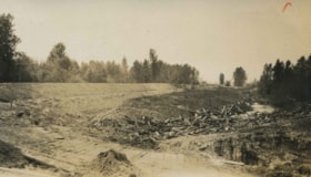
Construction of dykes on Nicomen Island
https://search.heritageburnaby.ca/link/archivedescription34330
- Repository
- City of Burnaby Archives
- Date
- 1927
- Collection/Fonds
- Burnaby Historical Society fonds
- Description Level
- Item
- Physical Description
- 1 photograph : sepia ; 5 x 13.5 cm on page 17.5 x 22.7 cm
- Scope and Content
- Photograph of a farm and field along the Fraser River next to dykes that are being built on Nicomen Island.
- Repository
- City of Burnaby Archives
- Date
- 1927
- Collection/Fonds
- Burnaby Historical Society fonds
- Subseries
- Peers family subseries
- Physical Description
- 1 photograph : sepia ; 5 x 13.5 cm on page 17.5 x 22.7 cm
- Description Level
- Item
- Record No.
- 020-037
- Access Restriction
- No restrictions
- Reproduction Restriction
- No known restrictions
- Accession Number
- BHS2007-04
- Scope and Content
- Photograph of a farm and field along the Fraser River next to dykes that are being built on Nicomen Island.
- Media Type
- Photograph
- Notes
- Title based on caption accompanying photograph
Images


Dyke construction on Nicomen Island
https://search.heritageburnaby.ca/link/archivedescription34332
- Repository
- City of Burnaby Archives
- Date
- 1927
- Collection/Fonds
- Burnaby Historical Society fonds
- Description Level
- Item
- Physical Description
- 1 photograph : sepia ; 5.7 x 13.2 cm on page 17.5 x 22.7 cm
- Scope and Content
- Photograph of machinery and equipment working on the construction of dykes on Nicomen Island.
- Repository
- City of Burnaby Archives
- Date
- 1927
- Collection/Fonds
- Burnaby Historical Society fonds
- Subseries
- Peers family subseries
- Physical Description
- 1 photograph : sepia ; 5.7 x 13.2 cm on page 17.5 x 22.7 cm
- Description Level
- Item
- Record No.
- 020-039
- Access Restriction
- No restrictions
- Reproduction Restriction
- No known restrictions
- Accession Number
- BHS2007-04
- Scope and Content
- Photograph of machinery and equipment working on the construction of dykes on Nicomen Island.
- Media Type
- Photograph
- Notes
- Title based on caption accompanying photograph
Images


Dykes on Nicomen Island
https://search.heritageburnaby.ca/link/archivedescription34333
- Repository
- City of Burnaby Archives
- Date
- 1927
- Collection/Fonds
- Burnaby Historical Society fonds
- Description Level
- Item
- Physical Description
- 1 photograph : sepia ; 6.5 x 13.7 cm on page 17.5 x 22.7 cm
- Scope and Content
- Photograph of a barn (in the background), along the river bank near the dykes under construction on Nicomen Island.
- Repository
- City of Burnaby Archives
- Date
- 1927
- Collection/Fonds
- Burnaby Historical Society fonds
- Subseries
- Peers family subseries
- Physical Description
- 1 photograph : sepia ; 6.5 x 13.7 cm on page 17.5 x 22.7 cm
- Description Level
- Item
- Record No.
- 020-040
- Access Restriction
- No restrictions
- Reproduction Restriction
- No known restrictions
- Accession Number
- BHS2007-04
- Scope and Content
- Photograph of a barn (in the background), along the river bank near the dykes under construction on Nicomen Island.
- Media Type
- Photograph
- Notes
- Title based on caption accompanying photograph
Images


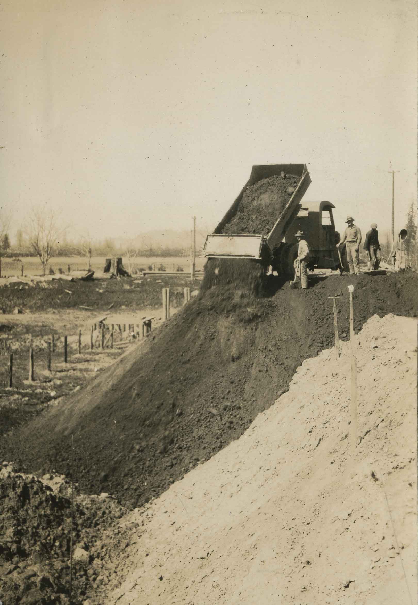
Dump truck on Nicomen Island
https://search.heritageburnaby.ca/link/archivedescription34338
- Repository
- City of Burnaby Archives
- Date
- 1927
- Collection/Fonds
- Burnaby Historical Society fonds
- Description Level
- Item
- Physical Description
- 1 photograph : sepia ; 7 x 10 cm on page 17.4 x 22.5 cm
- Scope and Content
- Photograph of a dump truck dumping a load of fill, with three unidentified workmen standing nearby. The picture was taken at Nicomen Island during the construction of the dykes.
- Repository
- City of Burnaby Archives
- Date
- 1927
- Collection/Fonds
- Burnaby Historical Society fonds
- Subseries
- Peers family subseries
- Physical Description
- 1 photograph : sepia ; 7 x 10 cm on page 17.4 x 22.5 cm
- Description Level
- Item
- Record No.
- 020-045
- Access Restriction
- No restrictions
- Reproduction Restriction
- No known restrictions
- Accession Number
- BHS2007-04
- Scope and Content
- Photograph of a dump truck dumping a load of fill, with three unidentified workmen standing nearby. The picture was taken at Nicomen Island during the construction of the dykes.
- Media Type
- Photograph
- Notes
- Title based on caption accompanying photograph
Images

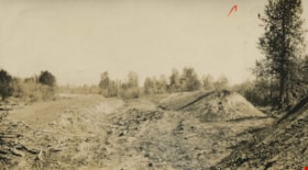
Dyke construction on Nicomen Island
https://search.heritageburnaby.ca/link/archivedescription34331
- Repository
- City of Burnaby Archives
- Date
- 1927
- Collection/Fonds
- Burnaby Historical Society fonds
- Description Level
- Item
- Physical Description
- 1 photograph : sepia ; 7 x 13.5 cm on page 17.5 x 22.7 cm
- Scope and Content
- Photograph of a home, with car in the foreground next to equipment being used in the construction of dykes on Nicomen Island.
- Repository
- City of Burnaby Archives
- Date
- 1927
- Collection/Fonds
- Burnaby Historical Society fonds
- Subseries
- Peers family subseries
- Physical Description
- 1 photograph : sepia ; 7 x 13.5 cm on page 17.5 x 22.7 cm
- Description Level
- Item
- Record No.
- 020-038
- Access Restriction
- No restrictions
- Reproduction Restriction
- No known restrictions
- Accession Number
- BHS2007-04
- Scope and Content
- Photograph of a home, with car in the foreground next to equipment being used in the construction of dykes on Nicomen Island.
- Subjects
- Construction Tools and Equipment
- Geographic Features - Dykes
- Buildings - Residential - Houses
- Media Type
- Photograph
- Notes
- Title based on caption accompanying photograph
Images

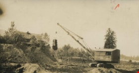
Nicomen Dyke Construction
https://search.heritageburnaby.ca/link/archivedescription34339
- Repository
- City of Burnaby Archives
- Date
- 1927
- Collection/Fonds
- Burnaby Historical Society fonds
- Description Level
- Item
- Physical Description
- 1 photograph : b&w ; 6.3 x 11.6 cm on page 17.4 x 23.9 cm
- Scope and Content
- Photograph of equipment being used to construct dykes on Nicomen Island.
- Repository
- City of Burnaby Archives
- Date
- 1927
- Collection/Fonds
- Burnaby Historical Society fonds
- Subseries
- Peers family subseries
- Physical Description
- 1 photograph : b&w ; 6.3 x 11.6 cm on page 17.4 x 23.9 cm
- Description Level
- Item
- Record No.
- 020-046
- Access Restriction
- No restrictions
- Reproduction Restriction
- No known restrictions
- Accession Number
- BHS2007-04
- Scope and Content
- Photograph of equipment being used to construct dykes on Nicomen Island.
- Media Type
- Photograph
- Notes
- Title based on caption accompanying photograph
Images
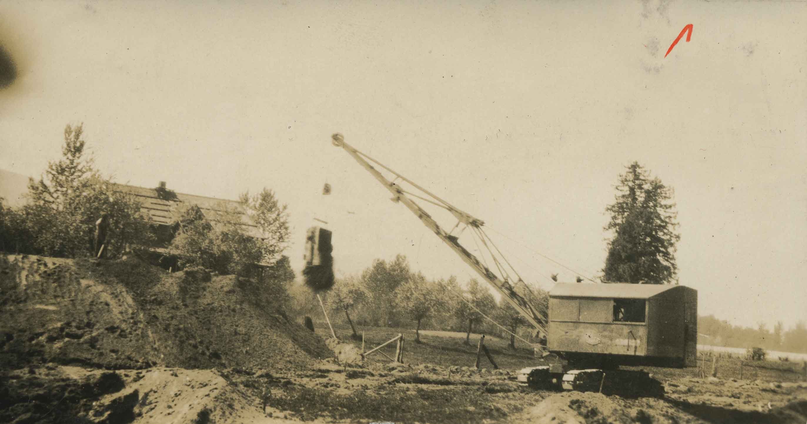
Nicomen Dykes
https://search.heritageburnaby.ca/link/archivedescription34340
- Repository
- City of Burnaby Archives
- Date
- 1927
- Collection/Fonds
- Burnaby Historical Society fonds
- Description Level
- Item
- Physical Description
- 1 photograph : b&w ; 7.7 x 12.9 cm on page 17.4 x 23.9 cm
- Scope and Content
- Photograph of equipment being used to construct dykes on Nicomen Island.
- Repository
- City of Burnaby Archives
- Date
- 1927
- Collection/Fonds
- Burnaby Historical Society fonds
- Subseries
- Peers family subseries
- Physical Description
- 1 photograph : b&w ; 7.7 x 12.9 cm on page 17.4 x 23.9 cm
- Description Level
- Item
- Record No.
- 020-047
- Access Restriction
- No restrictions
- Reproduction Restriction
- No known restrictions
- Accession Number
- BHS2007-04
- Scope and Content
- Photograph of equipment being used to construct dykes on Nicomen Island.
- Media Type
- Photograph
- Notes
- Title based on caption accompanying photograph
Images

Nicomen Dykes
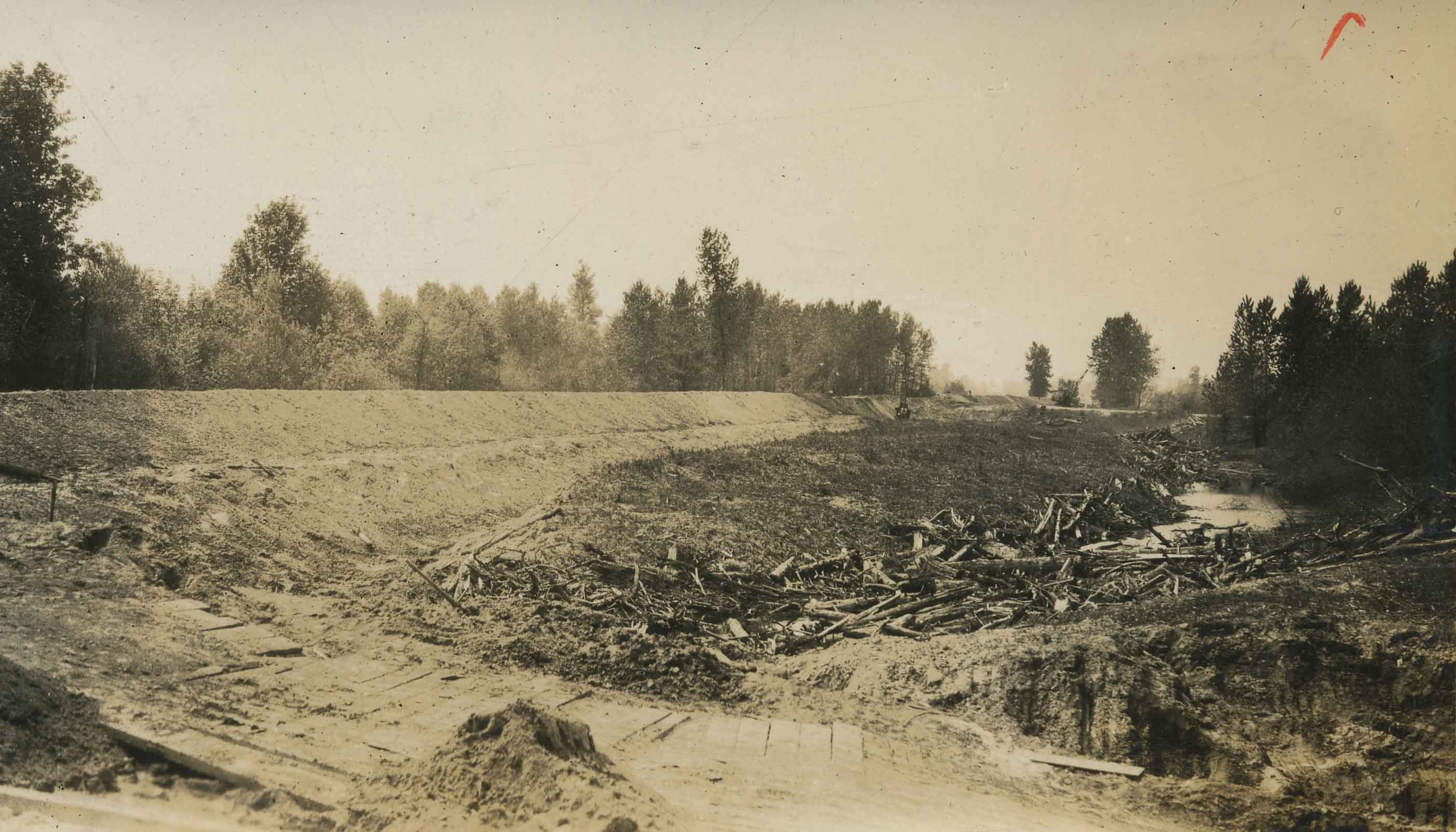
https://search.heritageburnaby.ca/link/archivedescription34342
- Repository
- City of Burnaby Archives
- Date
- 1927
- Collection/Fonds
- Burnaby Historical Society fonds
- Description Level
- Item
- Physical Description
- 1 photograph : b&w ; 6.8 x 12 cm on page 17.4 x 23.9 cm
- Scope and Content
- Photograph of the site of construction of dykes on Nicomen Island.
- Repository
- City of Burnaby Archives
- Date
- 1927
- Collection/Fonds
- Burnaby Historical Society fonds
- Subseries
- Peers family subseries
- Physical Description
- 1 photograph : b&w ; 6.8 x 12 cm on page 17.4 x 23.9 cm
- Description Level
- Item
- Record No.
- 020-049
- Access Restriction
- No restrictions
- Reproduction Restriction
- No known restrictions
- Accession Number
- BHS2007-04
- Scope and Content
- Photograph of the site of construction of dykes on Nicomen Island.
- Subjects
- Construction
- Geographic Features - Dykes
- Media Type
- Photograph
- Notes
- Title based on caption accompanying photograph
Images
Nicomen Dykes
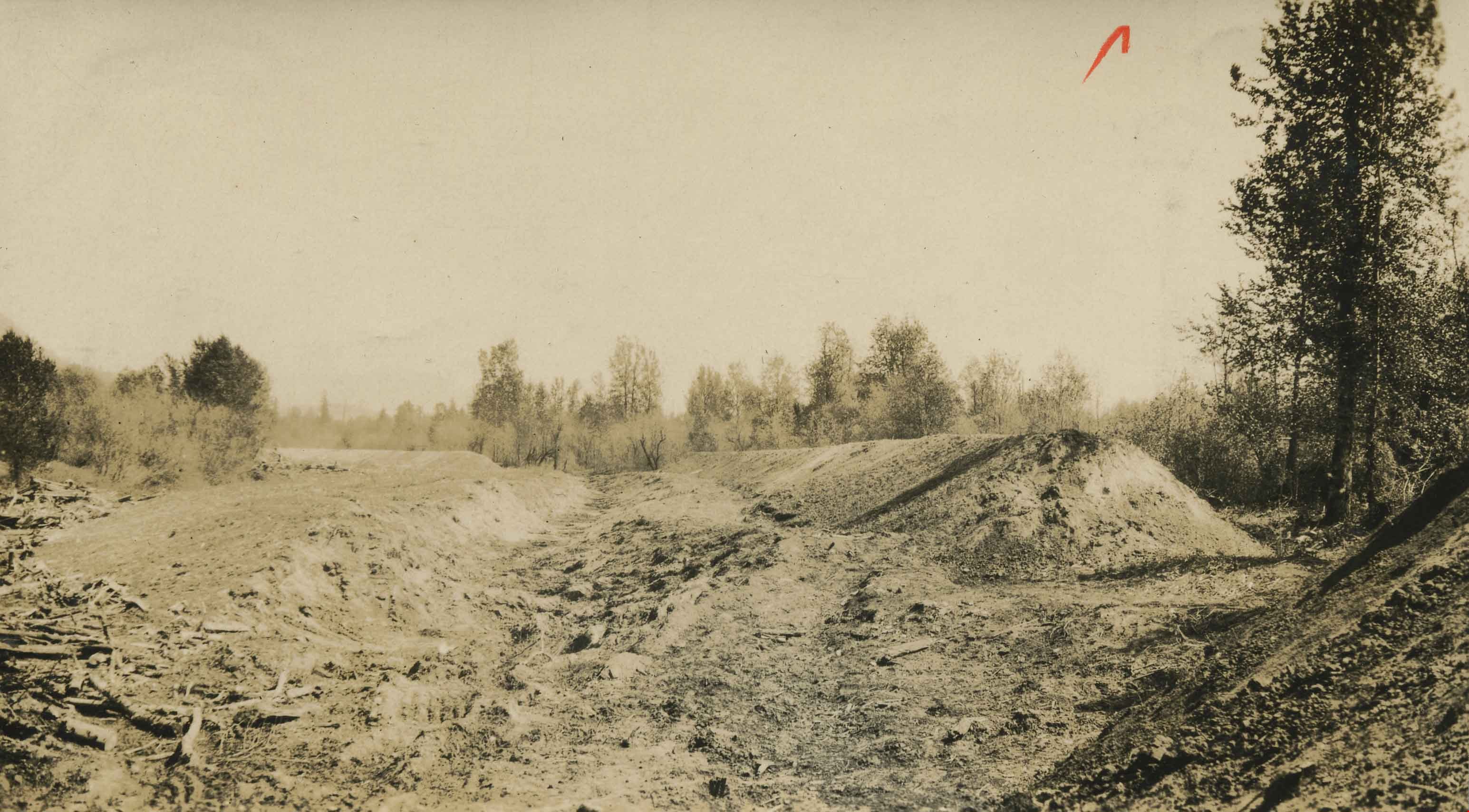
https://search.heritageburnaby.ca/link/archivedescription34341
- Repository
- City of Burnaby Archives
- Date
- 1927
- Collection/Fonds
- Burnaby Historical Society fonds
- Description Level
- Item
- Physical Description
- 1 photograph : b&w ; 7.4 x 13.2 cm on page 17.4 x 23.9 cm
- Scope and Content
- Photograph of dykes on Nicomen Island.
- Repository
- City of Burnaby Archives
- Date
- 1927
- Collection/Fonds
- Burnaby Historical Society fonds
- Subseries
- Peers family subseries
- Physical Description
- 1 photograph : b&w ; 7.4 x 13.2 cm on page 17.4 x 23.9 cm
- Description Level
- Item
- Record No.
- 020-048
- Access Restriction
- No restrictions
- Reproduction Restriction
- No known restrictions
- Accession Number
- BHS2007-04
- Scope and Content
- Photograph of dykes on Nicomen Island.
- Subjects
- Geographic Features - Dykes
- Media Type
- Photograph
- Notes
- Title based on caption accompanying photograph
Images
![Cut at 1st Tunnel Under Construction - Pete Grundahl's Gang, [1925] thumbnail](/media/hpo/_Data/_Archives_Images/_Unrestricted/001/020-118.jpg?width=280)
Cut at 1st Tunnel Under Construction - Pete Grundahl's Gang
https://search.heritageburnaby.ca/link/archivedescription34411
- Repository
- City of Burnaby Archives
- Date
- [1925]
- Collection/Fonds
- Burnaby Historical Society fonds
- Description Level
- Item
- Physical Description
- 1 photograph : b&w ; 12.5 x 17.5 cm on page 17.5 x 26.5 cm
- Scope and Content
- Photograph of a work crew hauling rocks and preparing a site for road construction. A caption accompanying the photograph reads "Cut at 1st Tunnel Under Construction - Pete Grundahl's Gang." This photograph appears to have been taken by Arthur Peers, who travelled through the Fraser River Valley …
- Repository
- City of Burnaby Archives
- Date
- [1925]
- Collection/Fonds
- Burnaby Historical Society fonds
- Subseries
- Peers family subseries
- Physical Description
- 1 photograph : b&w ; 12.5 x 17.5 cm on page 17.5 x 26.5 cm
- Description Level
- Item
- Record No.
- 020-118
- Access Restriction
- No restrictions
- Reproduction Restriction
- No known restrictions
- Accession Number
- BHS2007-04
- Scope and Content
- Photograph of a work crew hauling rocks and preparing a site for road construction. A caption accompanying the photograph reads "Cut at 1st Tunnel Under Construction - Pete Grundahl's Gang." This photograph appears to have been taken by Arthur Peers, who travelled through the Fraser River Valley and worked on the construction of the Trans-Provincial Highway during the later 1920s.
- Media Type
- Photograph
- Photographer
- Peers, Arthur Francis "Mike"
- Notes
- Title based on caption accompanying photograph
Images
![Cut at 1st Tunnel Under Construction - Pete Grundahl's Gang, [1925] thumbnail](/media/hpo/_Data/_Archives_Images/_Unrestricted/001/020-118.jpg)

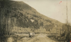
Nicomen Slough
https://search.heritageburnaby.ca/link/archivedescription34336
- Repository
- City of Burnaby Archives
- Date
- 1927
- Collection/Fonds
- Burnaby Historical Society fonds
- Description Level
- Item
- Physical Description
- 1 photograph : sepia ; 6.8 x 12 cm on page 17.4 x 22.5 cm
- Scope and Content
- Photograph of Nicomen Slough during the construction of the bridge and dykes on Nicomen Island.
- Repository
- City of Burnaby Archives
- Date
- 1927
- Collection/Fonds
- Burnaby Historical Society fonds
- Subseries
- Peers family subseries
- Physical Description
- 1 photograph : sepia ; 6.8 x 12 cm on page 17.4 x 22.5 cm
- Description Level
- Item
- Record No.
- 020-043
- Access Restriction
- No restrictions
- Reproduction Restriction
- No known restrictions
- Accession Number
- BHS2007-04
- Scope and Content
- Photograph of Nicomen Slough during the construction of the bridge and dykes on Nicomen Island.
- Media Type
- Photograph
- Notes
- Title based on caption accompanying photograph
Images

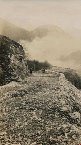
Rock bluff over complete roadway
https://search.heritageburnaby.ca/link/archivedescription34491
- Repository
- City of Burnaby Archives
- Date
- 1926
- Collection/Fonds
- Burnaby Historical Society fonds
- Description Level
- Item
- Physical Description
- 1 photograph : b&w ; 7 x 12 cm on page 17.5 x 26.4 cm
- Scope and Content
- Photograph of an unidentified man standing on a rock roadway identified as the Canadian Pacific Railway roadway near Yale, BC. This photograph appears to have been taken by Arthur Peers, who travelled through the Fraser River Valley and worked on the construction of the Trans-Provincial Highway du…
- Repository
- City of Burnaby Archives
- Date
- 1926
- Collection/Fonds
- Burnaby Historical Society fonds
- Subseries
- Peers family subseries
- Physical Description
- 1 photograph : b&w ; 7 x 12 cm on page 17.5 x 26.4 cm
- Description Level
- Item
- Record No.
- 020-198
- Access Restriction
- No restrictions
- Reproduction Restriction
- No known restrictions
- Accession Number
- BHS2007-04
- Scope and Content
- Photograph of an unidentified man standing on a rock roadway identified as the Canadian Pacific Railway roadway near Yale, BC. This photograph appears to have been taken by Arthur Peers, who travelled through the Fraser River Valley and worked on the construction of the Trans-Provincial Highway during the later 1920s.
- Media Type
- Photograph
- Photographer
- Peers, Arthur Francis "Mike"
- Notes
- Title based on caption accompanying photograph
Images

![Rock cut in Fraser River Canyon at Mile 24, [1925] thumbnail](/media/hpo/_Data/_Archives_Images/_Unrestricted/001/020-121.jpg?width=280)
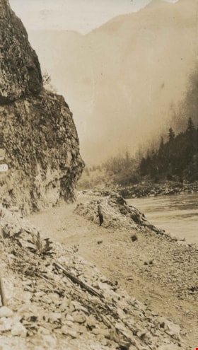
Rock cut in Fraser River Canyon at Mile 24
https://search.heritageburnaby.ca/link/archivedescription34414
- Repository
- City of Burnaby Archives
- Date
- [1925]
- Collection/Fonds
- Burnaby Historical Society fonds
- Description Level
- Item
- Physical Description
- 1 photograph : b&w ; 5.9 x 12 cm on page 17.5 x 26.1 cm
- Scope and Content
- Photograph of rock that has been cut in preparation for railroad construction. A caption acompanying the photograph reads: "rock cut in Fraser River Canyon at Mile 24." This photograph appears to have been taken by Arthur Peers, who travelled through the Fraser River Valley and worked on the cons…
- Repository
- City of Burnaby Archives
- Date
- [1925]
- Collection/Fonds
- Burnaby Historical Society fonds
- Subseries
- Peers family subseries
- Physical Description
- 1 photograph : b&w ; 5.9 x 12 cm on page 17.5 x 26.1 cm
- Description Level
- Item
- Record No.
- 020-121
- Access Restriction
- No restrictions
- Reproduction Restriction
- No known restrictions
- Accession Number
- BHS2007-04
- Scope and Content
- Photograph of rock that has been cut in preparation for railroad construction. A caption acompanying the photograph reads: "rock cut in Fraser River Canyon at Mile 24." This photograph appears to have been taken by Arthur Peers, who travelled through the Fraser River Valley and worked on the construction of the Trans-Provincial Highway during the later 1920s.
- Media Type
- Photograph
- Photographer
- Peers, Arthur Francis "Mike"
- Notes
- Title based on caption accompanying photograph
Images
![Rock cut in Fraser River Canyon at Mile 24, [1925] thumbnail](/media/hpo/_Data/_Archives_Images/_Unrestricted/001/020-121.jpg)
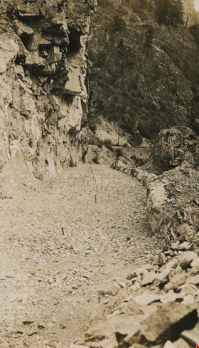
Rock cut round the first tunnel
https://search.heritageburnaby.ca/link/archivedescription34405
- Repository
- City of Burnaby Archives
- Date
- 1925
- Collection/Fonds
- Burnaby Historical Society fonds
- Description Level
- Item
- Physical Description
- 1 photograph : b&w ; 7 x 12 cm on page 17.5 x 26.5 cm
- Scope and Content
- Photograph of a road bed being cut along a rock face. A caption written under the photograph reads "rock cut round the first tunnel - the far side." The picture was taken near Yale, BC. This photograph appears to have been taken by Arthur Peers, who travelled through the Fraser River Valley and …
- Repository
- City of Burnaby Archives
- Date
- 1925
- Collection/Fonds
- Burnaby Historical Society fonds
- Subseries
- Peers family subseries
- Physical Description
- 1 photograph : b&w ; 7 x 12 cm on page 17.5 x 26.5 cm
- Description Level
- Item
- Record No.
- 020-112
- Access Restriction
- No restrictions
- Reproduction Restriction
- No known restrictions
- Accession Number
- BHS2007-04
- Scope and Content
- Photograph of a road bed being cut along a rock face. A caption written under the photograph reads "rock cut round the first tunnel - the far side." The picture was taken near Yale, BC. This photograph appears to have been taken by Arthur Peers, who travelled through the Fraser River Valley and worked on the construction of the Trans-Provincial Highway during the later 1920s.
- Media Type
- Photograph
- Photographer
- Peers, Arthur Francis "Mike"
- Notes
- Title based on caption accompanying photograph
Images

Rock cut round the first tunnel
https://search.heritageburnaby.ca/link/archivedescription34406
- Repository
- City of Burnaby Archives
- Date
- 1925
- Collection/Fonds
- Burnaby Historical Society fonds
- Description Level
- Item
- Physical Description
- 1 photograph : b&w ; 7 x 12.2 cm on page 17.5 x 26.5 cm
- Scope and Content
- Photograph of a road bed being cut along a rock face. A caption written under the photograph reads "rock cut round the first tunnel - the near side." The picture was taken near Yale, BC. This photograph appears to have been taken by Arthur Peers, who travelled through the Fraser River Valley and…
- Repository
- City of Burnaby Archives
- Date
- 1925
- Collection/Fonds
- Burnaby Historical Society fonds
- Subseries
- Peers family subseries
- Physical Description
- 1 photograph : b&w ; 7 x 12.2 cm on page 17.5 x 26.5 cm
- Description Level
- Item
- Record No.
- 020-113
- Access Restriction
- No restrictions
- Reproduction Restriction
- No known restrictions
- Accession Number
- BHS2007-04
- Scope and Content
- Photograph of a road bed being cut along a rock face. A caption written under the photograph reads "rock cut round the first tunnel - the near side." The picture was taken near Yale, BC. This photograph appears to have been taken by Arthur Peers, who travelled through the Fraser River Valley and worked on the construction of the Trans-Provincial Highway during the later 1920s.
- Media Type
- Photograph
- Photographer
- Peers, Arthur Francis "Mike"
- Notes
- Title based on caption accompanying photograph
Images
![Rock slide, December 10, [1926] thumbnail](/media/hpo/_Data/_Archives_Images/_Unrestricted/001/020-178.jpg?width=280)
Rock slide
https://search.heritageburnaby.ca/link/archivedescription34471
- Repository
- City of Burnaby Archives
- Date
- December 10, [1926]
- Collection/Fonds
- Burnaby Historical Society fonds
- Description Level
- Item
- Physical Description
- 1 photograph : b&w ; 7 x 11.5 cm on page 17.5 x 26.3 cm
- Scope and Content
- Photograph of three men standing on a wooden bridge next to two large boulders which have tumbled down from the rocky slope above. The caption accompanying the photograph reads: "Rock slide, Dec. 10th. Derailed Imperial Limited at 4am abd bent the overhead Bridge." This photograph appears to have…
- Repository
- City of Burnaby Archives
- Date
- December 10, [1926]
- Collection/Fonds
- Burnaby Historical Society fonds
- Subseries
- Peers family subseries
- Physical Description
- 1 photograph : b&w ; 7 x 11.5 cm on page 17.5 x 26.3 cm
- Description Level
- Item
- Record No.
- 020-178
- Access Restriction
- No restrictions
- Reproduction Restriction
- No known restrictions
- Accession Number
- BHS2007-04
- Scope and Content
- Photograph of three men standing on a wooden bridge next to two large boulders which have tumbled down from the rocky slope above. The caption accompanying the photograph reads: "Rock slide, Dec. 10th. Derailed Imperial Limited at 4am abd bent the overhead Bridge." This photograph appears to have been taken by Arthur Peers, who travelled through the Fraser River Valley and worked on the construction of the Trans-Provincial Highway during the later 1920s.
- Media Type
- Photograph
- Photographer
- Peers, Arthur Francis "Mike"
- Notes
- Title based on caption accompanying photograph
Images
![Rock slide, December 10, [1926] thumbnail](/media/hpo/_Data/_Archives_Images/_Unrestricted/001/020-178.jpg)
![The Three Ways Through the Canyon, [1925] thumbnail](/media/hpo/_Data/_Archives_Images/_Unrestricted/001/020-122.jpg?width=280)
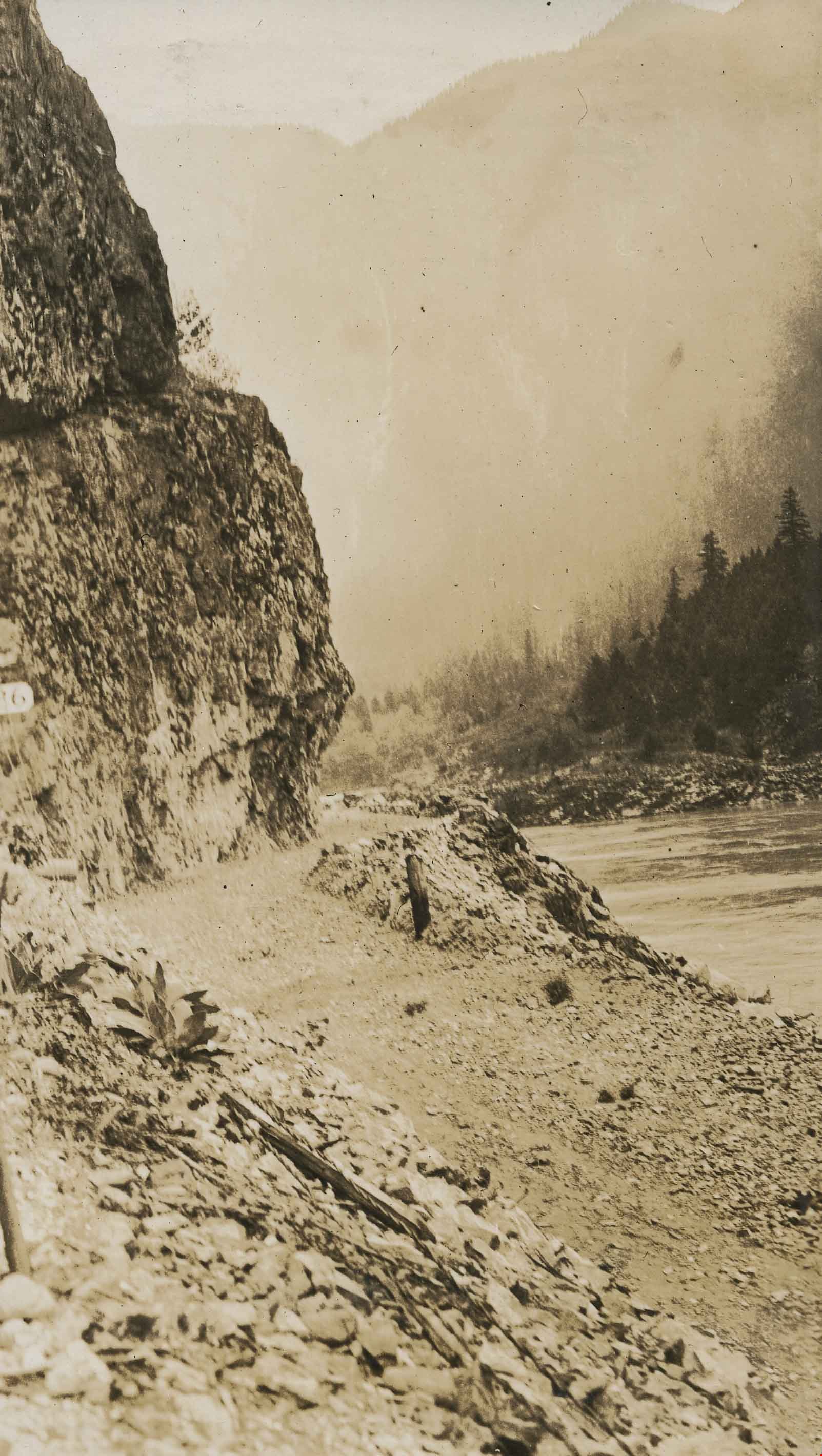
The Three Ways Through the Canyon
https://search.heritageburnaby.ca/link/archivedescription34415
- Repository
- City of Burnaby Archives
- Date
- [1925]
- Collection/Fonds
- Burnaby Historical Society fonds
- Description Level
- Item
- Physical Description
- 1 photograph : b&w ; 6.7 x 12 cm on page 17.5 x 26.1 cm
- Scope and Content
- Photograph of the view looking down the Fraser River. On the right, in the background, the CNR line is visible, while on the left can be seen the CPR line (closer to the river) and the Trans-Provincial Highway above that. These three routes are what is being referred to in the caption that accomp…
- Repository
- City of Burnaby Archives
- Date
- [1925]
- Collection/Fonds
- Burnaby Historical Society fonds
- Subseries
- Peers family subseries
- Physical Description
- 1 photograph : b&w ; 6.7 x 12 cm on page 17.5 x 26.1 cm
- Description Level
- Item
- Record No.
- 020-122
- Access Restriction
- No restrictions
- Reproduction Restriction
- No known restrictions
- Accession Number
- BHS2007-04
- Scope and Content
- Photograph of the view looking down the Fraser River. On the right, in the background, the CNR line is visible, while on the left can be seen the CPR line (closer to the river) and the Trans-Provincial Highway above that. These three routes are what is being referred to in the caption that accompanies the picture, and which reads: "The Three Ways Through the Canyon." This photograph appears to have been taken by Arthur Peers, who travelled through the Fraser River Valley and worked on the construction of the Trans-Provincial Highway during the later 1920s.
- Media Type
- Photograph
- Photographer
- Peers, Arthur Francis "Mike"
- Notes
- Title based on caption accompanying photograph
Images
![The Three Ways Through the Canyon, [1925] thumbnail](/media/hpo/_Data/_Archives_Images/_Unrestricted/001/020-122.jpg)
![Construction of Elworth, [1922] thumbnail](/media/hpo/_Data/_BVM_Images/1976/1976_0037_0001_001.jpg?width=280)
Construction of Elworth
https://search.heritageburnaby.ca/link/museumdescription676
- Repository
- Burnaby Village Museum
- Date
- [1922]
- Collection/Fonds
- E.W. Bateman family fonds
- Description Level
- Item
- Physical Description
- 1 photograph : b&w ; 6.9 x 11.5 cm
- Scope and Content
- Phoptograph of the construction of Mr. and Mrs. Edwin W. and Mary Bateman's house "Elworth." The path in the garden to the front porch has already been established in the photograph, and the frames of the house are erected, with side panels being fitted for the first floor. At least three people …
- Repository
- Burnaby Village Museum
- Collection/Fonds
- E.W. Bateman family fonds
- Description Level
- Item
- Physical Description
- 1 photograph : b&w ; 6.9 x 11.5 cm
- Scope and Content
- Phoptograph of the construction of Mr. and Mrs. Edwin W. and Mary Bateman's house "Elworth." The path in the garden to the front porch has already been established in the photograph, and the frames of the house are erected, with side panels being fitted for the first floor. At least three people are sitting by the openings made for the windows. Stamped on the back of the photo: "216." The house is located at the site of what would become Burnaby Village Museum, 6501 Deer Lake Avenue.
- Geographic Access
- Deer Lake Avenue
- Street Address
- 6501 Deer Lake Avenue
- Accession Code
- HV976.37.1
- Access Restriction
- No restrictions
- Reproduction Restriction
- No known restrictions
- Date
- [1922]
- Media Type
- Photograph
- Historic Neighbourhood
- Burnaby Lake (Historic Neighbourhood)
- Planning Study Area
- Morley-Buckingham Area
- Scan Resolution
- 600
- Scan Date
- 2023-06-13
- Notes
- Title based on contents of photograph
Images
![Construction of Elworth, [1922] thumbnail](/media/hpo/_Data/_BVM_Images/1976/1976_0037_0001_001.jpg)

Deer Lake Gibraltar
https://search.heritageburnaby.ca/link/archivedescription34312
- Repository
- City of Burnaby Archives
- Date
- 1924
- Collection/Fonds
- Burnaby Historical Society fonds
- Description Level
- Item
- Physical Description
- 1 photograph : b&w ; 8.1 x 13.2 cm
- Scope and Content
- Photograph of the "Gibraltar" rock at mouth of Deer Lake Creek. This photograph was taken during the winter of 1924 and the lake is frozen over with ice. The surface of the lake is covered with marks made by ice skates. Deer Lake Creek is historically known as Deer Lake Brook.
- Repository
- City of Burnaby Archives
- Date
- 1924
- Collection/Fonds
- Burnaby Historical Society fonds
- Subseries
- Peers family subseries
- Physical Description
- 1 photograph : b&w ; 8.1 x 13.2 cm
- Description Level
- Item
- Record No.
- 020-019
- Access Restriction
- No restrictions
- Reproduction Restriction
- No known restrictions
- Accession Number
- BHS2007-04
- Scope and Content
- Photograph of the "Gibraltar" rock at mouth of Deer Lake Creek. This photograph was taken during the winter of 1924 and the lake is frozen over with ice. The surface of the lake is covered with marks made by ice skates. Deer Lake Creek is historically known as Deer Lake Brook.
- Subjects
- Geographic Features - Creeks
- Geographic Features - Lakes and Ponds
- Geographic Features - Rock Formations
- Media Type
- Photograph
- Notes
- Title based on caption accompanying photograph
- Geographic Access
- Deer Lake Brook
- Historic Neighbourhood
- Burnaby Lake (Historic Neighbourhood)
- Planning Study Area
- Morley-Buckingham Area
Images

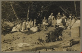
Alouette Lake
https://search.heritageburnaby.ca/link/archivedescription82611
- Repository
- City of Burnaby Archives
- Date
- June 21, 1925
- Collection/Fonds
- Hill family and Vidal family fonds
- Description Level
- Item
- Physical Description
- 1 photograph : sepia, mounted on cardboard ; 12.5 x 17 cm
- Scope and Content
- Photograph is a portrait of men, women, and children on the beach of Alouette Lake. The fourth woman from the left is identified as Charlotte Hill. The man to the right of her is identified as Minard Hill.
- Repository
- City of Burnaby Archives
- Date
- June 21, 1925
- Collection/Fonds
- Hill family and Vidal family fonds
- Physical Description
- 1 photograph : sepia, mounted on cardboard ; 12.5 x 17 cm
- Description Level
- Item
- Record No.
- 550-175
- Access Restriction
- No restrictions
- Reproduction Restriction
- No known restrictions
- Accession Number
- 2013-03
- Scope and Content
- Photograph is a portrait of men, women, and children on the beach of Alouette Lake. The fourth woman from the left is identified as Charlotte Hill. The man to the right of her is identified as Minard Hill.
- Media Type
- Photograph
- Notes
- Title based on note accompanying photograph
- Note in black pen on the cardboard reads: "Alouette Lake / June 21, 1925"
- Accompanying newspaper clipping attached to album page is titled "Surveyors' Examinations"
Images
