Narrow Results By
Format
- Architectural Drawing 235
- Book
- Bylaws - Adopted 2195
- Bylaws - Other 9
- Bylaws - Repealed 171
- Cartographic Material 72
- Council - Committee Report 4514
- Council - Manager's Report 6114
- Council - Mayor/Councillor/Staff Report 3681
- Council - Public Hearing Minutes 123
- Council - Regular Council Minutes 882
- Graphic Material 22
Subject
- Accidents 2
- Accidents - Automobile Accidents 2
- Accidents - Train Accidents 1
- Adornment - Jewelry 1
- Advertising Medium 1
- Advertising Medium - Signs and Signboards 18
- Aerial Photographs 2
- Agricultural Tools and Equipment 2
- Agricultural Tools and Equipment - Gardening Equipment 2
- Agricultural Tools and Equipment - Plows 1
- Agriculture 3
- Agriculture - Crops 7
Creator
- Ackerknecht, Erwin H. (Erwin Heinz), 1906-1988 1
- Adams, Morley 1
- Adams, Peter 1
- Adams, St. Clair, 1883- 2
- Aikens, Charlotte A. (Charlotte Albina), 1868- 1
- Alberta. Alberta Culture 1
- Alcott, Louisa May, 1832-1888 1
- Alexander, William John, 1855-1944 1
- Allen, John Robins, 1869-1920 1
- Alter, Ian 1
- American Association of Youth Museums 2
- American college of surgeons 6
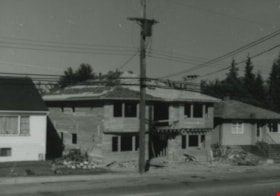
6778 Walker Avenue construction
https://search.heritageburnaby.ca/link/archivedescription37868
- Repository
- City of Burnaby Archives
- Date
- July 1985 (date of original), copied 1991
- Collection/Fonds
- Burnaby Historical Society fonds
- Description Level
- Item
- Physical Description
- 1 photograph : b&w ; 3.2 x 4.6 cm print on contact sheet 20.4 x 26.7 cm
- Scope and Content
- Photograph of the construction of a house at 6778 Walker Avenue.
- Repository
- City of Burnaby Archives
- Date
- July 1985 (date of original), copied 1991
- Collection/Fonds
- Burnaby Historical Society fonds
- Subseries
- Burnaby Image Bank subseries
- Physical Description
- 1 photograph : b&w ; 3.2 x 4.6 cm print on contact sheet 20.4 x 26.7 cm
- Description Level
- Item
- Record No.
- 370-456
- Access Restriction
- No restrictions
- Reproduction Restriction
- No restrictions
- Accession Number
- BHS1999-03
- Scope and Content
- Photograph of the construction of a house at 6778 Walker Avenue.
- Media Type
- Photograph
- Notes
- Title based on contents of photograph
- 1 b&w copy negative accompanying
- Negative has a pink cast
- Copied from col. photograph
- Geographic Access
- Walker Avenue
- Street Address
- 6778 Walker Avenue
- Historic Neighbourhood
- Edmonds (Historic Neighbourhood)
- Planning Study Area
- Richmond Park Area
Images
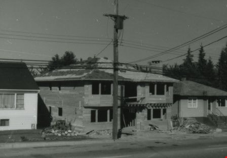
6778 Walker Avenue construction
https://search.heritageburnaby.ca/link/archivedescription37869
- Repository
- City of Burnaby Archives
- Date
- August 1985 (date of original), copied 1991
- Collection/Fonds
- Burnaby Historical Society fonds
- Description Level
- Item
- Physical Description
- 1 photograph : b&w ; 3.2 x 4.6 cm print on contact sheet 20.4 x 26.7 cm
- Scope and Content
- Photograph of the construction of a house at 6778 Walker Avenue.
- Repository
- City of Burnaby Archives
- Date
- August 1985 (date of original), copied 1991
- Collection/Fonds
- Burnaby Historical Society fonds
- Subseries
- Burnaby Image Bank subseries
- Physical Description
- 1 photograph : b&w ; 3.2 x 4.6 cm print on contact sheet 20.4 x 26.7 cm
- Description Level
- Item
- Record No.
- 370-457
- Access Restriction
- No restrictions
- Reproduction Restriction
- No restrictions
- Accession Number
- BHS1999-03
- Scope and Content
- Photograph of the construction of a house at 6778 Walker Avenue.
- Media Type
- Photograph
- Notes
- Title based on contents of photograph
- 1 b&w copy negative accompanying
- Negative has a pink cast
- Copied from col. photograph
- Geographic Access
- Walker Avenue
- Street Address
- 6778 Walker Avenue
- Historic Neighbourhood
- Edmonds (Historic Neighbourhood)
- Planning Study Area
- Richmond Park Area
Images

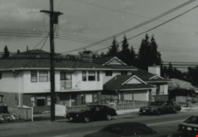
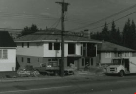
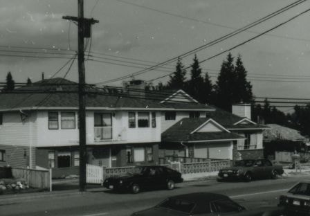
6790 Walker Avenue
https://search.heritageburnaby.ca/link/archivedescription37871
- Repository
- City of Burnaby Archives
- Date
- 1986 (date of original), copied 1991
- Collection/Fonds
- Burnaby Historical Society fonds
- Description Level
- Item
- Physical Description
- 1 photograph : b&w ; 3.2 x 4.6 cm print on contact sheet 20.1 x 26.7 cm
- Scope and Content
- Photograph of 6790 Walker Avenue, summer 1986. Cars are parked on the street.
- Repository
- City of Burnaby Archives
- Date
- 1986 (date of original), copied 1991
- Collection/Fonds
- Burnaby Historical Society fonds
- Subseries
- Burnaby Image Bank subseries
- Physical Description
- 1 photograph : b&w ; 3.2 x 4.6 cm print on contact sheet 20.1 x 26.7 cm
- Description Level
- Item
- Record No.
- 370-459
- Access Restriction
- No restrictions
- Reproduction Restriction
- No restrictions
- Accession Number
- BHS1999-03
- Scope and Content
- Photograph of 6790 Walker Avenue, summer 1986. Cars are parked on the street.
- Subjects
- Buildings - Residential - Houses
- Media Type
- Photograph
- Notes
- Title based on contents of photograph
- 1 b&w copy negative accompanying
- Negative has a pink cast
- Copied from col. photograph
- 2 b&w copy prints accompanying
- Geographic Access
- Walker Avenue
- Street Address
- 6790 Walker Avenue
- Historic Neighbourhood
- Edmonds (Historic Neighbourhood)
- Planning Study Area
- Richmond Park Area
Images
6850 20th Avenue
https://search.heritageburnaby.ca/link/archivedescription93728
- Repository
- City of Burnaby Archives
- Date
- March 1989
- Collection/Fonds
- Grover, Elliott & Co. Ltd. fonds
- Description Level
- File
- Physical Description
- 31 photographs : col. negatives ; 35 mm
- Scope and Content
- Photographs of an industrial property located at 6850 20th Avenue during construction. 6850 20th Avenue is an address that no longer exists.
- Repository
- City of Burnaby Archives
- Date
- March 1989
- Collection/Fonds
- Grover, Elliott & Co. Ltd. fonds
- Physical Description
- 31 photographs : col. negatives ; 35 mm
- Description Level
- File
- Record No.
- 622-016
- Access Restriction
- No restrictions
- Reproduction Restriction
- No restrictions
- Accession Number
- 2017-39
- Scope and Content
- Photographs of an industrial property located at 6850 20th Avenue during construction. 6850 20th Avenue is an address that no longer exists.
- Media Type
- Photograph
- Notes
- Transcribed title
- Title transcribed from original print envelope
- Geographic Access
- 20th Avenue
- Planning Study Area
- Stride Hill Area
7018-7092 Lougheed Hwy [at] SW intersection w/ Bainbridge Ave
https://search.heritageburnaby.ca/link/archivedescription93715
- Repository
- City of Burnaby Archives
- Date
- 1987
- Collection/Fonds
- Grover, Elliott & Co. Ltd. fonds
- Description Level
- File
- Physical Description
- 17 photographs : col. ; 10 cm x 15 cm
- Scope and Content
- Photographs of the commercial properties located at 7018-7092 Lougheed Highway and the surrounding area. Photographs depict the buildings' exteriors, interiors, and roof. Also included in the file is one photograph of a map of Sechelt being marked up.
- Repository
- City of Burnaby Archives
- Date
- 1987
- Collection/Fonds
- Grover, Elliott & Co. Ltd. fonds
- Physical Description
- 17 photographs : col. ; 10 cm x 15 cm
- Description Level
- File
- Record No.
- 622-004
- Access Restriction
- No restrictions
- Reproduction Restriction
- No restrictions
- Accession Number
- 2017-39
- Scope and Content
- Photographs of the commercial properties located at 7018-7092 Lougheed Highway and the surrounding area. Photographs depict the buildings' exteriors, interiors, and roof. Also included in the file is one photograph of a map of Sechelt being marked up.
- Media Type
- Photograph
- Notes
- Transcribed title
- Title transcribed from original print envelope
- File no. 87-201-B
- Geographic Access
- Lougheed Highway
- Street Address
- 7018 Lougheed Highway
- Planning Study Area
- Government Road Area
![7342 Curtis Street, [1981] thumbnail](/media/hpo/_Data/_Archives_Images/_Unrestricted/371/382-002.jpg?width=280)
7342 Curtis Street
https://search.heritageburnaby.ca/link/archivedescription38276
- Repository
- City of Burnaby Archives
- Date
- [1981]
- Collection/Fonds
- Burnaby Historical Society fonds
- Description Level
- Item
- Physical Description
- 1 photograph : b&w ; 9 x 12.5 cm
- Scope and Content
- Photograph of the house located at 7342 Curtis Street.
- Repository
- City of Burnaby Archives
- Date
- [1981]
- Collection/Fonds
- Burnaby Historical Society fonds
- Subseries
- Photographs subseries
- Physical Description
- 1 photograph : b&w ; 9 x 12.5 cm
- Description Level
- Item
- Record No.
- 382-002
- Access Restriction
- No restrictions
- Reproduction Restriction
- Reproduce for fair dealing purposes only
- Accession Number
- BHS1999-12
- Scope and Content
- Photograph of the house located at 7342 Curtis Street.
- Subjects
- Buildings - Residential - Houses
- Media Type
- Photograph
- Notes
- Title based on contents of photograph
- Geographic Access
- Curtis Street
- Street Address
- 7342 Curtis Street
- Historic Neighbourhood
- Lochdale (Historic Neighbourhood)
- Planning Study Area
- Lochdale Area
Images
![7342 Curtis Street, [1981] thumbnail](/media/hpo/_Data/_Archives_Images/_Unrestricted/371/382-002.jpg)
7818 6th Street
https://search.heritageburnaby.ca/link/archivedescription93731
- Repository
- City of Burnaby Archives
- Date
- 1989
- Collection/Fonds
- Grover, Elliott & Co. Ltd. fonds
- Description Level
- File
- Physical Description
- 26 photographs : col. negatives ; 35 mm
- Scope and Content
- Photographs of the exterior of a Benjamin Moore Paints store and surrounding area. The store is located on a corner opposite Microtel and outside the store, a sign for the Skytrain Operations and Maintenance Centre is visible.
- Repository
- City of Burnaby Archives
- Date
- 1989
- Collection/Fonds
- Grover, Elliott & Co. Ltd. fonds
- Physical Description
- 26 photographs : col. negatives ; 35 mm
- Description Level
- File
- Record No.
- 622-019
- Access Restriction
- No restrictions
- Reproduction Restriction
- No restrictions
- Accession Number
- 2017-39
- Scope and Content
- Photographs of the exterior of a Benjamin Moore Paints store and surrounding area. The store is located on a corner opposite Microtel and outside the store, a sign for the Skytrain Operations and Maintenance Centre is visible.
- Media Type
- Photograph
- Notes
- Transcribed title
- Title transcribed from original print envelope
- File no. 89v-004-O
- Property address could not be confirmed at time of description.
- Geographic Access
- 6th Street
- 12th Avenue
- Street Address
- 7818 6th Street
- Historic Neighbourhood
- East Burnaby (Historic Neighbourhood)
- Planning Study Area
- Second Street Area
7973-7993 Enterprise St
https://search.heritageburnaby.ca/link/archivedescription93718
- Repository
- City of Burnaby Archives
- Date
- 1987
- Collection/Fonds
- Grover, Elliott & Co. Ltd. fonds
- Description Level
- File
- Physical Description
- 14 photographs : col. ; 10 cm x 15 cm
- Scope and Content
- Photographs of the exterior of the commercial complex located at 7973 and 7993 Enterprise Street. Businesses visible in the photographs include: Universal, Philips, Canpar, Boss Cartage, and Hercules Forwarding Ltd.
- Repository
- City of Burnaby Archives
- Date
- 1987
- Collection/Fonds
- Grover, Elliott & Co. Ltd. fonds
- Physical Description
- 14 photographs : col. ; 10 cm x 15 cm
- Description Level
- File
- Record No.
- 622-007
- Access Restriction
- No restrictions
- Reproduction Restriction
- No restrictions
- Accession Number
- 2017-39
- Scope and Content
- Photographs of the exterior of the commercial complex located at 7973 and 7993 Enterprise Street. Businesses visible in the photographs include: Universal, Philips, Canpar, Boss Cartage, and Hercules Forwarding Ltd.
- Media Type
- Photograph
- Notes
- Transcribed title
- Title transcribed from original print envelope
- File no. 87-485-B
- Geographic Access
- Enterprise Street
- Street Address
- 7973 Enterprise Street
- 7993 Enterprise Street
- Planning Study Area
- Lake City Area
8357 Tenth Avenue, 8350 and 8353 Eleventh Avenue
https://search.heritageburnaby.ca/link/archivedescription93724
- Repository
- City of Burnaby Archives
- Date
- 1989
- Collection/Fonds
- Grover, Elliott & Co. Ltd. fonds
- Description Level
- File
- Physical Description
- 24 photographs : col. negatives ; 35 mm
- Scope and Content
- Photographs of the exterior of the low-rise apartment complex located at 8357 10th Avenue and 8350 and 8353 11th Avenue and the laneway running between the buildings.
- Repository
- City of Burnaby Archives
- Date
- 1989
- Collection/Fonds
- Grover, Elliott & Co. Ltd. fonds
- Physical Description
- 24 photographs : col. negatives ; 35 mm
- Description Level
- File
- Record No.
- 622-013
- Access Restriction
- No restrictions
- Reproduction Restriction
- No restrictions
- Accession Number
- 2017-39
- Scope and Content
- Photographs of the exterior of the low-rise apartment complex located at 8357 10th Avenue and 8350 and 8353 11th Avenue and the laneway running between the buildings.
- Media Type
- Photograph
- Notes
- Transcribed title
- Title transcribed from original print envelope
- Geographic Access
- 10th Avenue
- 11th Avenue
- Street Address
- 8357 10th Avenue
- 8350 11th Avenue
- 8353 11th Avenue
- Historic Neighbourhood
- East Burnaby (Historic Neighbourhood)
- Planning Study Area
- Cariboo-Armstrong Area
8553 Eastlake Drive
https://search.heritageburnaby.ca/link/archivedescription93729
- Repository
- City of Burnaby Archives
- Date
- March 6, 1989
- Collection/Fonds
- Grover, Elliott & Co. Ltd. fonds
- Description Level
- File
- Physical Description
- 23 photographs : col. negatives ; 35 mm
- Scope and Content
- Photographs of an undeveloped property located at 8553 Eastlake Drive, the roads, and the surrounding area. 8553 Eastlake Drive is an address that no longer exists.
- Repository
- City of Burnaby Archives
- Date
- March 6, 1989
- Collection/Fonds
- Grover, Elliott & Co. Ltd. fonds
- Physical Description
- 23 photographs : col. negatives ; 35 mm
- Description Level
- File
- Record No.
- 622-017
- Access Restriction
- No restrictions
- Reproduction Restriction
- No restrictions
- Accession Number
- 2017-39
- Scope and Content
- Photographs of an undeveloped property located at 8553 Eastlake Drive, the roads, and the surrounding area. 8553 Eastlake Drive is an address that no longer exists.
- Media Type
- Photograph
- Photographer
- Young, J.
- Notes
- Transcribed title
- Title transcribed from original print envelope
- Geographic Access
- Eastlake Drive
- Planning Study Area
- Lake City Area
8575 Government Street
https://search.heritageburnaby.ca/link/archivedescription93738
- Repository
- City of Burnaby Archives
- Date
- March 1989
- Collection/Fonds
- Grover, Elliott & Co. Ltd. fonds
- Description Level
- File
- Physical Description
- 4 photographs : col. ; 10 cm x 15 cm
- Scope and Content
- Photographs of the industrial complex located at 8575 Government Street under construction.
- Repository
- City of Burnaby Archives
- Date
- March 1989
- Collection/Fonds
- Grover, Elliott & Co. Ltd. fonds
- Physical Description
- 4 photographs : col. ; 10 cm x 15 cm
- Description Level
- File
- Record No.
- 622-023
- Access Restriction
- No restrictions
- Reproduction Restriction
- No restrictions
- Accession Number
- 2017-39
- Scope and Content
- Photographs of the industrial complex located at 8575 Government Street under construction.
- Media Type
- Photograph
- Notes
- Transcribed title
- Title transcribed from sticky note adhered to photograph 622-023-1
- File no. 89-125-B
- Photograph 622-023-1 caption reads: "View north from Government Street"
- Photograph 622-023-2 caption reads: "Eastern view along Government Street; Note Gaglardi Way overpass"
- Photograph 622-023-3 caption reads: "Rear of building"
- Photograph 622-023-4 caption reads: "Southern view along main facade"
- Photograph captions transcribed from the paper on which the photographs were originally adhered.
- Geographic Access
- Government Street
- Street Address
- 8575 Government Street
- Planning Study Area
- Lake City Area
8651 Eastlake Drive
https://search.heritageburnaby.ca/link/archivedescription93742
- Repository
- City of Burnaby Archives
- Date
- July 26, 1989
- Collection/Fonds
- Grover, Elliott & Co. Ltd. fonds
- Description Level
- File
- Physical Description
- 6 photographs : col. negatives ; 35 mm + 7 photographs : col. ; 10 cm x 15 cm
- Scope and Content
- Photographs of various industrial properties in Burnaby, BC. Tenants of the buildings include: Western Unitool, Baron Glass, Baxter, and Barton of Canada Ltd.
- Repository
- City of Burnaby Archives
- Date
- July 26, 1989
- Collection/Fonds
- Grover, Elliott & Co. Ltd. fonds
- Physical Description
- 6 photographs : col. negatives ; 35 mm + 7 photographs : col. ; 10 cm x 15 cm
- Description Level
- File
- Record No.
- 622-027
- Access Restriction
- No restrictions
- Reproduction Restriction
- No restrictions
- Accession Number
- 2017-39
- Scope and Content
- Photographs of various industrial properties in Burnaby, BC. Tenants of the buildings include: Western Unitool, Baron Glass, Baxter, and Barton of Canada Ltd.
- Media Type
- Photograph
- Notes
- Transcribed title
- Title transcribed from print envelope photographs were originally housed in
- File no. 89-298-B
- Note on original negative sleeve reads: "Comps/Ackland"
8855 Northbrook Court
https://search.heritageburnaby.ca/link/archivedescription93735
- Repository
- City of Burnaby Archives
- Date
- 1989
- Collection/Fonds
- Grover, Elliott & Co. Ltd. fonds
- Description Level
- File
- Physical Description
- 21 photographs : col. negatives ; 35 mm
- Scope and Content
- Photographs of an undeveloped property loacated at 8855 Northbrook Court. Construction equipment is visible in the distance.
- Repository
- City of Burnaby Archives
- Date
- 1989
- Collection/Fonds
- Grover, Elliott & Co. Ltd. fonds
- Physical Description
- 21 photographs : col. negatives ; 35 mm
- Description Level
- File
- Record No.
- 622-020
- Access Restriction
- No restrictions
- Reproduction Restriction
- No restrictions
- Accession Number
- 2017-39
- Scope and Content
- Photographs of an undeveloped property loacated at 8855 Northbrook Court. Construction equipment is visible in the distance.
- Media Type
- Photograph
- Notes
- Transcribed title
- Title transcribed from original print envelope
- File no. 89-037-B
- Geographic Access
- Northbrook Court
- Street Address
- 8855 Northbrook Court
- Historic Neighbourhood
- Fraser Arm (Historic Neighbourhood)
- Planning Study Area
- Big Bend Area
9303 Salish Court
https://search.heritageburnaby.ca/link/archivedescription93719
- Repository
- City of Burnaby Archives
- Date
- 1989
- Collection/Fonds
- Grover, Elliott & Co. Ltd. fonds
- Description Level
- File
- Physical Description
- 2 photographs : col. ; 10 cm x 15 cm
- Scope and Content
- Photographs of the exterior of an apartment or condominium complex located at 9303 Salish Court. In one of the photographs the complex is in the foreground; in the second the photograph is in the top left corner with another complex, Aquarius Gardens, in the foreground.
- Repository
- City of Burnaby Archives
- Date
- 1989
- Collection/Fonds
- Grover, Elliott & Co. Ltd. fonds
- Physical Description
- 2 photographs : col. ; 10 cm x 15 cm
- Description Level
- File
- Record No.
- 622-008
- Access Restriction
- No restrictions
- Reproduction Restriction
- No restrictions
- Accession Number
- 2017-39
- Scope and Content
- Photographs of the exterior of an apartment or condominium complex located at 9303 Salish Court. In one of the photographs the complex is in the foreground; in the second the photograph is in the top left corner with another complex, Aquarius Gardens, in the foreground.
- Subjects
- Buildings - Residential - Apartments
- Media Type
- Photograph
- Notes
- Transcribed title
- Title transcribed from photograph 622-008-1
- Geographic Access
- Salish Court
- Street Address
- 9303 Salish Court
- Planning Study Area
- Lake City Area
9444 Cameron Street
https://search.heritageburnaby.ca/link/archivedescription93720
- Repository
- City of Burnaby Archives
- Date
- 1989
- Collection/Fonds
- Grover, Elliott & Co. Ltd. fonds
- Description Level
- File
- Physical Description
- 2 photographs : col. ; 10 cm x 15 cm
- Scope and Content
- Photographs of a three-storey apartment complex located at 9444 Cameron Street.
- Repository
- City of Burnaby Archives
- Date
- 1989
- Collection/Fonds
- Grover, Elliott & Co. Ltd. fonds
- Physical Description
- 2 photographs : col. ; 10 cm x 15 cm
- Description Level
- File
- Record No.
- 622-009
- Access Restriction
- No restrictions
- Reproduction Restriction
- No restrictions
- Accession Number
- 2017-39
- Scope and Content
- Photographs of a three-storey apartment complex located at 9444 Cameron Street.
- Subjects
- Buildings - Residential - Apartments
- Media Type
- Photograph
- Notes
- Transcribed title
- Title transcribed from photograph 622-009-1
- Geographic Access
- Cameron Street
- Street Address
- 9444 Cameron Street
- Planning Study Area
- Lake City Area
Abilene's carousel
https://search.heritageburnaby.ca/link/museumlibrary1020
- Repository
- Burnaby Village Museum
- Author
- Harris, Cecilia
- Publication Date
- 1988
- Call Number
- 745 HAR COPY 1
- Repository
- Burnaby Village Museum
- Collection
- Reference Collection
- Material Type
- Book
- Call Number
- 745 HAR COPY 1
- Author
- Harris, Cecilia
- Place of Publication
- [Abilene, Kan]
- Publisher
- [s.n.]
- Publication Date
- 1988
- Physical Description
- 48 p. : ill. ; 21 cm.
- Library Subject (LOC)
- Merry-go-round--History
- Notes
- 2 copies held: copy 1 of 2.
Abraham Lincoln : a play
https://search.heritageburnaby.ca/link/museumlibrary1715
- Repository
- Burnaby Village Museum
- Author
- Drinkwater, John, 1882-1937
- Edition
- New ed.
- Publication Date
- c1927
- Call Number
- 822.9 DRI
- Repository
- Burnaby Village Museum
- Collection
- Special Collection
- Material Type
- Book
- Accession Code
- HV984.21.28
- Call Number
- 822.9 DRI
- Edition
- New ed.
- Author
- Drinkwater, John, 1882-1937
- Place of Publication
- Toronto
- Publisher
- Copp, Clark
- Publication Date
- c1927
- Physical Description
- xiv, 112 p. ; 19 cm.
- Inscription
- Front endpaper: "Department of Education Text-Book Branch" [sticker adhered to book] "1934" [written on sticker in blue ink] "A 30" [written in pencil] Throughout book: Study notes and markings highlighting passages of text, written in pencil.
- Library Subject (LOC)
- Presidents--United States--Drama
- Notes
- "With Introduction and Study Helps" -- t.p.
- School ed.
A Canadian school geography
https://search.heritageburnaby.ca/link/museumlibrary8
- Repository
- Burnaby Village Museum
- Collection
- Special Collection
- Material Type
- Book
- Accession Code
- HV971.5.7
- Call Number
- 917.1 COR 1929
- Contributor
- Denton, V. L. (Vernon Llewllyn), 1881-1944
- Place of Publication
- Toronto
- Publisher
- J. M. Dent & Son Ltd.
- Publication Date
- 1929
- Printer
- Richard Clay & Sons, Limited
- Physical Description
- xiv, 498 p. : ill., maps ; 20 cm.
- Inscription
- "Department of Education Text-Book Branch" [label pasted onto front pastedown] "W-2d" [handwritten in black ink on "Department of Education" label on front pastedown] "218-227 supplement as regards your ____" [handwritten in black ink on front pastedown] "Canada 1932" [handwritten in black ink on front endpaper] "F94" [handwritten in pencil on front endpaper] "In case of fire Throw this in" [handwritten in pencil on back of front endpaper] "Patricia Jeffery" [stamped in black ink on supplement title page] "Class 4 P. N. S." [handwritten in black ink on supplement title page] "Patricia Jeffery" [handwritten in black ink on title page verso]
- Library Subject (LOC)
- Geography--Textbooks
- Canada--Description and travel
- Geography--Historical texts
- Notes
- "with numberous sketch maps, diagrams and illustrations"--T.p.
- "Authorized for use in the schools of British Columbia, Manitoba, Nova Scotia, Quebec and Saskatchewan" --T.p.
- "With a supplementary chapter on British Columbia by V.L. Denton"
- Supplementary chapter on British Columbia p. 451-498
- Author's given name and dates: Cornish, George A. (George Augustus), 1872-1960
- Author's given name and dates: Denton, V.L. (Vernon Llewllyn), 1881-1944
A Canadian school geography
https://search.heritageburnaby.ca/link/museumlibrary348
- Repository
- Burnaby Village Museum
- Collection
- Special Collection
- Material Type
- Book
- Accession Code
- BV989.9.22
- Call Number
- 917.1 COR 1924 Copy 1
- Contributor
- Denton, V. L. (Vernon Llewllyn), 1881-1944
- Place of Publication
- Toronto
- Publisher
- J. M. Dent & Son Ltd.
- Publication Date
- 1924
- Printer
- Richard Clay & Sons, Limited
- Physical Description
- xiv, 498 p. : ill., maps ; 20 cm.
- Inscription
- "Ethel Anderson, 9387 Fullerton Ave., Victoria, B.C." [handwritten in black ink on front endpaper] "Ethel Anderson" [handwritten in pencil on front endpaper] Provinces and their capitals handwritten in pencil on back pastedown.
- Library Subject (LOC)
- Geography--Textbooks
- Canada--Description and travel
- Geography--Historical texts
- Notes
- "with numberous sketch maps, diagrams and illustrations"--T.p.
- "Authorized for use in the schools of British Columbia" --T.p.
- "With a supplementary chapter on British Columbia by V.L. Denton"
- Supplementary chapter on British Columbia p. 451-498
- Copy 1 of 2
- Author's given name and dates: Cornish, George A. (George Augustus), 1872-1960
- Author's given name and dates: Denton, V.L. (Vernon Llewllyn), 1881-1944
A Canadian school geography
https://search.heritageburnaby.ca/link/museumlibrary1744
- Repository
- Burnaby Village Museum
- Collection
- Special Collection
- Material Type
- Book
- Accession Code
- HV984.21.135
- Call Number
- 917.1 COR 1927
- Contributor
- Denton, V. L. (Vernon Llewllyn), 1881-1944
- Place of Publication
- Toronto
- Publisher
- J. M. Dent & Son Ltd.
- Publication Date
- 1927
- Printer
- Richard Clay & Sons, Limited
- Physical Description
- xiv, 498 p. : ill., maps ; 20 cm.
- Inscription
- "WOODWARDS LTD. BOOK DEPT. 90¢" [stamped in purple in on front endpaper] "Vera Morrow" [handwritten in red ink on front endpaper] "Section Page" [handwritten in pencil on front endpaper] "Vera Morrow" [handwritten in green ink on other side of front endpaper] "[All rights reserved] to Vera Morrow" [handwritten in red ink on page before t.p.] "Vera Morrow Kitchener St. school Geography Book (text)" [handwritten in pencil on back endpaper] Study notes handwritten in pencil in margins throughout the book
- Library Subject (LOC)
- Geography--Textbooks
- Canada--Description and travel
- Geography--Historical texts
- Notes
- "with numberous sketch maps, diagrams and illustrations"--T.p.
- "Authorized for use in the schools of British Columbia, Manitoba, Nova Scotia, Quebec and Saskatchewan" --T.p.
- "With a supplementary chapter on British Columbia by V.L. Denton"
- Supplementary chapter on British Columbia p. 451-498
- Author's given name and dates: Cornish, George A. (George Augustus), 1872-1960
- Author's given name and dates: Denton, V.L. (Vernon Llewllyn), 1881-1944