Narrow Results By
Subject
- Advertising Medium - Signs and Signboards
- Agriculture - Farms 2
- Animals - Goats 1
- Buildings - Commercial - Service Stations 1
- Buildings - Commercial - Stores 2
- Buildings - Industrial 2
- Buildings - Industrial - Factories 2
- Buildings - Industrial - Refineries 1
- Buildings - Recreational 1
- Buildings - Recreational - Bowling Alleys 1
- Buildings - Recreational - Swimming Pools 1
- Buildings - Residential - Cabins 3
Jubilee Avenue
https://search.heritageburnaby.ca/link/archivedescription35069
- Repository
- City of Burnaby Archives
- Date
- [192-] (date of original), copied 1986
- Collection/Fonds
- Burnaby Historical Society fonds
- Description Level
- Item
- Physical Description
- 1 photograph : b&w ; 11.4 x 7.1 cm
- Scope and Content
- Photograph of stores on Jubilee Avenue looking north from Imperial Street (later the location of Bonsor Park, 6550 Bonsor Avenue). Signs visible read; "Jubilee Drug Store," "Drugs," "Jubilee [Mercantile?] Co. / Groceries," "Nabob Tea," and "[Carvers or Corvers]." An accompanying description in the…
- Repository
- City of Burnaby Archives
- Date
- [192-] (date of original), copied 1986
- Collection/Fonds
- Burnaby Historical Society fonds
- Subseries
- Heyworth family subseries
- Physical Description
- 1 photograph : b&w ; 11.4 x 7.1 cm
- Description Level
- Item
- Record No.
- 187-002
- Access Restriction
- No restrictions
- Reproduction Restriction
- No known restrictions
- Accession Number
- BHS1986-38
- Scope and Content
- Photograph of stores on Jubilee Avenue looking north from Imperial Street (later the location of Bonsor Park, 6550 Bonsor Avenue). Signs visible read; "Jubilee Drug Store," "Drugs," "Jubilee [Mercantile?] Co. / Groceries," "Nabob Tea," and "[Carvers or Corvers]." An accompanying description in the accession file states that a man named Pat Flannagan ran the grocery.
- Media Type
- Photograph
- Notes
- Title based on contents of photograph
- Stamp on verso of photograph reads: "5272"
- Geographic Access
- Jubilee Avenue
- Bonsor Avenue
- Street Address
- 6550 Bonsor Avenue
- Historic Neighbourhood
- Central Park (Historic Neighbourhood)
- Planning Study Area
- Marlborough Area
Images
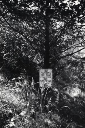
Taxi Zone Sign
https://search.heritageburnaby.ca/link/archivedescription79924
- Repository
- City of Burnaby Archives
- Date
- September 24, 1976
- Collection/Fonds
- Burnaby Public Library Contemporary Visual Archive Project
- Description Level
- Item
- Physical Description
- 1 photograph : b&w ; 11 x 16 cm mounted on cardboard
- Scope and Content
- Photograph shows a taxi zone sign on a tree in the wilderness area near Kask Kamp in the 7200 block of Barnet Road.
- Repository
- City of Burnaby Archives
- Date
- September 24, 1976
- Collection/Fonds
- Burnaby Public Library Contemporary Visual Archive Project
- Physical Description
- 1 photograph : b&w ; 11 x 16 cm mounted on cardboard
- Description Level
- Item
- Record No.
- 556-495
- Access Restriction
- No restrictions
- Reproduction Restriction
- Reproduce for fair dealing purposes only
- Accession Number
- 2013-13
- Scope and Content
- Photograph shows a taxi zone sign on a tree in the wilderness area near Kask Kamp in the 7200 block of Barnet Road.
- Media Type
- Photograph
- Photographer
- Born, A. J.
- Notes
- Scope note taken directly from BPL photograph description.
- 1 b&w copy negative : 10 x 12.5 cm accompanying
- Geographic Access
- Barnet Road
- Historic Neighbourhood
- Barnet (Historic Neighbourhood)
- Planning Study Area
- Burnaby Mountain Area
![Jubilee Avenue, [192-] (date of original), copied 1986 thumbnail](/media/hpo/_Data/_Archives_Images/_Unrestricted/126/187-002.jpg?width=280)
