Narrow Results By
Subject
- Advertising Medium - Signs and Signboards 1
- Aerial Photographs 1
- Agriculture - Farms 1
- Agriculture - Orchards 1
- Animals - Cats 1
- Animals - Cows 2
- Animals - Dogs 1
- Animals - Poultry 1
- Buildings - Civic - Hospitals 7
- Buildings - Civic - Libraries 2
- Buildings - Commercial - Grocery Stores 1
- Buildings - Commercial - Hardware Stores 15
Creator
- British Columbia Underwriters' Association 3
- Burnaby Village Museum 1
- Hodge, Craig 1
- Jones, Charles Spurgeon "Chuck" 1
- Lloyd's Studio 1
- McCarter & Nairne 1
- Nels Olund 1
- Parker, Albert "Bert" 23
- Petrusa, Kate 1
- Plan Department, British Columbia Insurance Underwriters' Association 3
- Ross, Martha 1
- Salmon, Stu 10
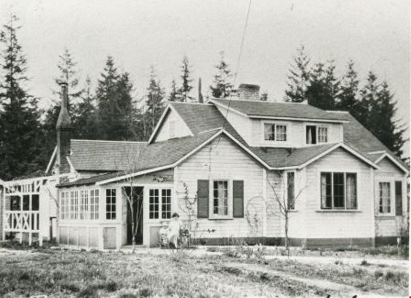
![Exterior view of Love farmhouse, [between 1966 and 1970] thumbnail](/media/hpo/_Data/_BVM_Images/2019/2019_0003_0011_001.jpg?width=280)
Exterior view of Love farmhouse
https://search.heritageburnaby.ca/link/museumdescription9921
- Repository
- Burnaby Village Museum
- Date
- [between 1966 and 1970]
- Collection/Fonds
- Love family fonds
- Description Level
- Item
- Physical Description
- 1 photograph : col. ; 10 x 15 cm print
- Scope and Content
- Photograph of the south east side of the Love farmhouse located at 7651 Cumberland Street (Address pre 1960: 1390 Cumberland Road). Flowers are growing on trellises against the pillars of the verandah and there are two wooden lawn chairs and a picnic table on the lawn under a large tree. This photo…
- Repository
- Burnaby Village Museum
- Collection/Fonds
- Love family fonds
- Description Level
- Item
- Physical Description
- 1 photograph : col. ; 10 x 15 cm print
- Material Details
- Copy print was made from re-photographing an original colour slide
- Scope and Content
- Photograph of the south east side of the Love farmhouse located at 7651 Cumberland Street (Address pre 1960: 1390 Cumberland Road). Flowers are growing on trellises against the pillars of the verandah and there are two wooden lawn chairs and a picnic table on the lawn under a large tree. This photograph was taken while Elsie Hughes (nee Love), her husband John Hughes and son Brent Hughes lived in the house. Elsie is the daughter of Sarah (nee Love) and William Parker. Sarah and William purchased the house in 1928, shortly after the death of Sarah's father, Jesse Love. Sarah and William Parker lived in the house with their three children, Albert, Bill and Elsie. William Parker died in 1961 and Sarah continued to live in the house until 1966 before selling it to her daughter Elsie and son in law John Hughes. Elsie and John lived in the house with their son Brent until 1971.
- Subjects
- Buildings - Heritage
- Geographic Access
- Cumberland Street
- Street Address
- 7651 Cumberland Street
- Accession Code
- BV019.3.11
- Access Restriction
- No restrictions
- Reproduction Restriction
- No known restrictions
- Date
- [between 1966 and 1970]
- Media Type
- Photograph
- Historic Neighbourhood
- East Burnaby (Historic Neighbourhood)
- Planning Study Area
- Cariboo-Armstrong Area
- Scan Resolution
- 600
- Scan Date
- 31-Jan-2019
- Scale
- 96
- Photographer
- Parker, Albert "Bert"
- Notes
- Title based on contents of photograph
Images
![Exterior view of Love farmhouse, [between 1966 and 1970] thumbnail](/media/hpo/_Data/_BVM_Images/2019/2019_0003_0011_001.jpg)
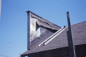
False front and roof of Whitechurch Hardware
https://search.heritageburnaby.ca/link/museumdescription16895
- Repository
- Burnaby Village Museum
- Date
- Aug. 1974
- Collection/Fonds
- Burnaby Village Museum fonds
- Description Level
- Item
- Physical Description
- 1 photograph : col. slide ; 35 mm
- Scope and Content
- Photograph of a portion of the roof with ladder and back of the false front of the Whitechurch Hardware building located at 7685 Sixth Street. The building was being prepared to be moved by the Nickel Brothers house moving company to Heritage Village (Burnaby Village Museum).
- Repository
- Burnaby Village Museum
- Collection/Fonds
- Burnaby Village Museum fonds
- Subseries
- Bell's building photographs subseries
- Description Level
- Item
- Physical Description
- 1 photograph : col. slide ; 35 mm
- Scope and Content
- Photograph of a portion of the roof with ladder and back of the false front of the Whitechurch Hardware building located at 7685 Sixth Street. The building was being prepared to be moved by the Nickel Brothers house moving company to Heritage Village (Burnaby Village Museum).
- Geographic Access
- 6th Street
- Street Address
- 7685 6th Street
- Accession Code
- BV020.5.1865
- Access Restriction
- No restrictions
- Reproduction Restriction
- No known restrictions
- Date
- Aug. 1974
- Media Type
- Photograph
- Historic Neighbourhood
- East Burnaby (Historic Neighbourhood)
- Planning Study Area
- Second Street Area
- Scan Resolution
- 2400
- Scale
- 100
- Notes
- Title based on contents of photograph
- Note in blue ink on slide frame reads: "Whitechurch Hrdwr. / Back of Original / False Front"
Images

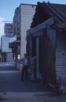
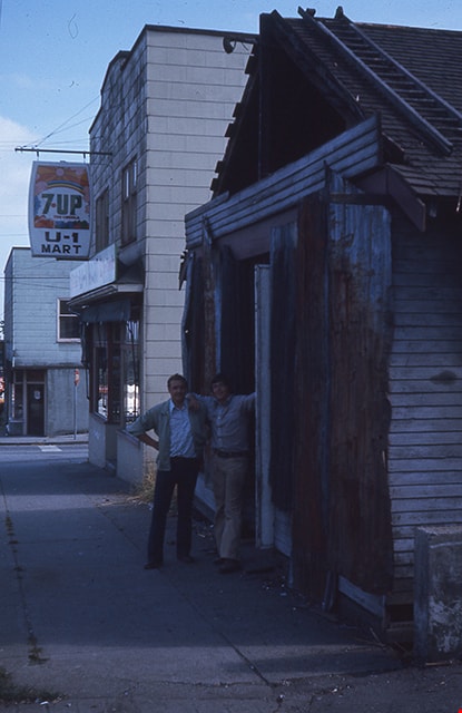
False front removal from Whitechurch Hardware
https://search.heritageburnaby.ca/link/museumdescription16886
- Repository
- Burnaby Village Museum
- Date
- Aug. 1974
- Collection/Fonds
- Burnaby Village Museum fonds
- Description Level
- Item
- Physical Description
- 1 photograph : col. slide ; 35 mm
- Scope and Content
- Photograph of Peter Otten (left) and Gysberton (right) standing in the doorway of the old Whitechurch Hardware building located at 7685 Sixth Street in Burnaby. The building was being prepared to be moved to the Heritage Village (Burnaby Village Museum) and the false front was removed. The Whitech…
- Repository
- Burnaby Village Museum
- Collection/Fonds
- Burnaby Village Museum fonds
- Subseries
- Bell's building photographs subseries
- Description Level
- Item
- Physical Description
- 1 photograph : col. slide ; 35 mm
- Scope and Content
- Photograph of Peter Otten (left) and Gysberton (right) standing in the doorway of the old Whitechurch Hardware building located at 7685 Sixth Street in Burnaby. The building was being prepared to be moved to the Heritage Village (Burnaby Village Museum) and the false front was removed. The Whitechurch Hardware business operated out of this building between 1937 and 1973 and Bell's Dry Goods operated out of this building between 1925 and 1937. A two storey building is visible in the background with a grocery convenience store on the ground level with sign "7-Up / U-1 / Mart" hanging above the entrance way. The two storey building was built in 1938 and operated as Bell's Dry Goods between 1937 and 1941.
- Geographic Access
- 6th Street
- Street Address
- 7695 6th Street
- 7685 6th Street
- Accession Code
- BV020.5.1856
- Access Restriction
- No restrictions
- Reproduction Restriction
- No known restrictions
- Date
- Aug. 1974
- Media Type
- Photograph
- Historic Neighbourhood
- East Burnaby (Historic Neighbourhood)
- Planning Study Area
- Second Street Area
- Scan Resolution
- 2400
- Scale
- 100
- Notes
- Title based on contents of photograph
- Note in blue ink on slide frame reads: "(FRONT) / VIEW FROM THIS SIDE / WRONG SIDE / Whitechurch Hardware / FalseFront Removal / Peter Otten (l) + co. / Gysbertson(r) in front"
- 1 col. copy print accompanying
Images

Front hallway entrance of Love farmhouse
https://search.heritageburnaby.ca/link/museumdescription1122
- Repository
- Burnaby Village Museum
- Date
- 1971 (date of original), copied 1990
- Collection/Fonds
- Love family fonds
- Description Level
- Item
- Physical Description
- 1 photograph : col. ; 15 x 10 cm print
- Scope and Content
- Photograph of the front hallway and entrance door of the Love farmhouse while Elsie (nee Love) Hughes, her husband John and son Brent lived in the house. The house was located at 7651 Cumberland Street (Address pre 1960: 1390 Cumberland Road) and was moved from its original site to the Burnaby Vill…
- Repository
- Burnaby Village Museum
- Collection/Fonds
- Love family fonds
- Description Level
- Item
- Physical Description
- 1 photograph : col. ; 15 x 10 cm print
- Material Details
- Copy print was made from re-photographing an original colour slide
- Scope and Content
- Photograph of the front hallway and entrance door of the Love farmhouse while Elsie (nee Love) Hughes, her husband John and son Brent lived in the house. The house was located at 7651 Cumberland Street (Address pre 1960: 1390 Cumberland Road) and was moved from its original site to the Burnaby Village Museum in 1988 and designated a Municipal Heritage Landmark in 1992.
- Geographic Access
- Cumberland Street
- Street Address
- 7651 Cumberland Street
- Accession Code
- BV992.15.3
- Access Restriction
- Restricted access
- Reproduction Restriction
- May be restricted by third party rights
- Date
- 1971 (date of original), copied 1990
- Media Type
- Photograph
- Historic Neighbourhood
- East Burnaby (Historic Neighbourhood)
- Planning Study Area
- Cariboo-Armstrong Area
- Scan Resolution
- 600
- Scan Date
- 01-Jun-09
- Scale
- 100
- Photographer
- Parker, Albert "Bert"
- Notes
- Title based on contents of photograph
Images

![Garden in Robert Burnaby Park, [between 1949 and 1959] (date of original), copied 2014 thumbnail](/media/hpo/_Data/_Archives_Images/_Unrestricted/580/581-011.jpg?width=280)
Garden in Robert Burnaby Park
https://search.heritageburnaby.ca/link/archivedescription88405
- Repository
- City of Burnaby Archives
- Date
- [between 1949 and 1959] (date of original), copied 2014
- Collection/Fonds
- James Massey family fonds
- Description Level
- Item
- Physical Description
- 1 photograph (tiff) : sepia ; 600 dpi
- Scope and Content
- Photograph of the garden and fence in Robert Burnaby Park. Alice Massey is standing in the centre of the photograph near a large bunch of poppies with an unidentified woman to the left.
- Repository
- City of Burnaby Archives
- Date
- [between 1949 and 1959] (date of original), copied 2014
- Collection/Fonds
- James Massey family fonds
- Physical Description
- 1 photograph (tiff) : sepia ; 600 dpi
- Description Level
- Item
- Record No.
- 581-011
- Access Restriction
- No restrictions
- Reproduction Restriction
- No restrictions
- Accession Number
- 2014-34
- Scope and Content
- Photograph of the garden and fence in Robert Burnaby Park. Alice Massey is standing in the centre of the photograph near a large bunch of poppies with an unidentified woman to the left.
- Media Type
- Photograph
- Notes
- Title based on contents of photograph
- Historic Neighbourhood
- East Burnaby (Historic Neighbourhood)
- Planning Study Area
- Lakeview-Mayfield Area
Images
![Garden in Robert Burnaby Park, [between 1949 and 1959] (date of original), copied 2014 thumbnail](/media/hpo/_Data/_Archives_Images/_Unrestricted/580/581-011.jpg)
![George Derby Health Centre, [between 1950 and 1954] (date of original), copied 1991 thumbnail](/media/hpo/_Data/_Archives_Images/_Unrestricted/370/370-121.jpg?width=280)
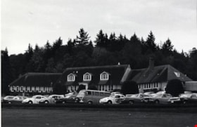
George Derby Health Centre
https://search.heritageburnaby.ca/link/archivedescription37533
- Repository
- City of Burnaby Archives
- Date
- [between 1950 and 1954] (date of original), copied 1991
- Collection/Fonds
- Burnaby Historical Society fonds
- Description Level
- Item
- Physical Description
- 1 photograph : b&w ; 2.5 x 4.1 cm print on contact sheet 20.2 x 25.3 cm
- Scope and Content
- Photograph of the George Derby Health Centre which includes the main building, parking lot and grounds.
- Repository
- City of Burnaby Archives
- Date
- [between 1950 and 1954] (date of original), copied 1991
- Collection/Fonds
- Burnaby Historical Society fonds
- Subseries
- Burnaby Image Bank subseries
- Physical Description
- 1 photograph : b&w ; 2.5 x 4.1 cm print on contact sheet 20.2 x 25.3 cm
- Description Level
- Item
- Record No.
- 370-121
- Access Restriction
- No restrictions
- Reproduction Restriction
- No restrictions
- Accession Number
- BHS1999-03
- Scope and Content
- Photograph of the George Derby Health Centre which includes the main building, parking lot and grounds.
- Subjects
- Geographic Features - Automobile Parking Lots
- Buildings - Civic - Hospitals
- Documentary Artifacts - Postcards
- Media Type
- Photograph
- Notes
- Title based on caption on photograph
- 1 b&w copy negative accompanying
- Print was copied from a postcard original
- Caption at bottom of photograph reads, "George Derby Health Centre / Burnaby B.C."
- Geographic Access
- Cumberland Street
- Street Address
- 7550 Cumberland Street
- Historic Neighbourhood
- East Burnaby (Historic Neighbourhood)
- Planning Study Area
- Cariboo-Armstrong Area
Images
![George Derby Health Centre, [between 1950 and 1954] (date of original), copied 1991 thumbnail](/media/hpo/_Data/_Archives_Images/_Unrestricted/370/370-121.jpg)
![George Derby Health Centre, [between 1950 and 1954] (date of original), copied 1991 thumbnail](/media/hpo/_Data/_Archives_Images/_Unrestricted/370/370-127.jpg?width=280)
George Derby Health Centre
https://search.heritageburnaby.ca/link/archivedescription37539
- Repository
- City of Burnaby Archives
- Date
- [between 1950 and 1954] (date of original), copied 1991
- Collection/Fonds
- Burnaby Historical Society fonds
- Description Level
- Item
- Physical Description
- 1 photograph : b&w ; 3.4 x 5.0 cm print on contact sheet 20.2 x 25.3 cm
- Scope and Content
- Aerial photograph of the George Derby Health Centre, copied from a postcard.
- Repository
- City of Burnaby Archives
- Date
- [between 1950 and 1954] (date of original), copied 1991
- Collection/Fonds
- Burnaby Historical Society fonds
- Subseries
- Burnaby Image Bank subseries
- Physical Description
- 1 photograph : b&w ; 3.4 x 5.0 cm print on contact sheet 20.2 x 25.3 cm
- Description Level
- Item
- Record No.
- 370-127
- Access Restriction
- No restrictions
- Reproduction Restriction
- No restrictions
- Accession Number
- BHS1999-03
- Scope and Content
- Aerial photograph of the George Derby Health Centre, copied from a postcard.
- Media Type
- Photograph
- Notes
- Title based on caption on photograph
- 1 b&w copy negative accompanying
- Caption on photograph reads, "George Derby Health Centre, Burnaby B.C."
- Geographic Access
- Cumberland Street
- Street Address
- 7550 Cumberland Street
- Historic Neighbourhood
- East Burnaby (Historic Neighbourhood)
- Planning Study Area
- Cariboo-Armstrong Area
Images
![George Derby Health Centre, [between 1950 and 1954] (date of original), copied 1991 thumbnail](/media/hpo/_Data/_Archives_Images/_Unrestricted/370/370-127.jpg)
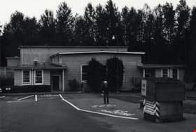
George Derby Hospital
https://search.heritageburnaby.ca/link/archivedescription79505
- Repository
- City of Burnaby Archives
- Date
- October, 1976
- Collection/Fonds
- Burnaby Public Library Contemporary Visual Archive Project
- Description Level
- Item
- Physical Description
- 1 photograph : b&w ; 11 x 16 cm mounted on cardboard
- Scope and Content
- Photograph of the administration building at George Derby Hospital. George Derby Health and Occupation Centre was constructed during the years 1946/1947. It was officially opened on April 10, 1947 at 7502 Cumberland Street (later 7550 Cumberland), on the corner of 17th Avenue. Its prime function wa…
- Repository
- City of Burnaby Archives
- Date
- October, 1976
- Collection/Fonds
- Burnaby Public Library Contemporary Visual Archive Project
- Physical Description
- 1 photograph : b&w ; 11 x 16 cm mounted on cardboard
- Description Level
- Item
- Record No.
- 556-332
- Access Restriction
- No restrictions
- Reproduction Restriction
- Reproduce for fair dealing purposes only
- Accession Number
- 2013-13
- Scope and Content
- Photograph of the administration building at George Derby Hospital. George Derby Health and Occupation Centre was constructed during the years 1946/1947. It was officially opened on April 10, 1947 at 7502 Cumberland Street (later 7550 Cumberland), on the corner of 17th Avenue. Its prime function was a rehabilitation centre for returning World War II veterans. In the fall of 1962 the Centre was amalgamated with Shaughnessy Hospital (Vancouver) and became the George Derby Wing.
- Subjects
- Buildings - Civic - Hospitals
- Media Type
- Photograph
- Photographer
- Salmon, Stu
- Notes
- Scope note taken directly from BPL photograph description
- 1 b&w copy negative : 10 x 12.5 cm accompanying
- Geographic Access
- Cumberland Street
- Street Address
- 7550 Cumberland Street
- Historic Neighbourhood
- East Burnaby (Historic Neighbourhood)
- Planning Study Area
- Cariboo-Armstrong Area
Images

George Derby Hospital
https://search.heritageburnaby.ca/link/archivedescription79506
- Repository
- City of Burnaby Archives
- Date
- October, 1976
- Collection/Fonds
- Burnaby Public Library Contemporary Visual Archive Project
- Description Level
- Item
- Physical Description
- 1 photograph : b&w ; 11 x 16 cm mounted on cardboard
- Scope and Content
- Photograph shows the treatment building at the George Derby Hospital.
- Repository
- City of Burnaby Archives
- Date
- October, 1976
- Collection/Fonds
- Burnaby Public Library Contemporary Visual Archive Project
- Physical Description
- 1 photograph : b&w ; 11 x 16 cm mounted on cardboard
- Description Level
- Item
- Record No.
- 556-333
- Access Restriction
- No restrictions
- Reproduction Restriction
- Reproduce for fair dealing purposes only
- Accession Number
- 2013-13
- Scope and Content
- Photograph shows the treatment building at the George Derby Hospital.
- Subjects
- Buildings - Civic - Hospitals
- Media Type
- Photograph
- Photographer
- Salmon, Stu
- Notes
- Scope note taken directly from BPL photograph description.
- 1 b&w copy negative : 10 x 12.5 cm accompanying
- Geographic Access
- Cumberland Street
- Street Address
- 7550 Cumberland Street
- Historic Neighbourhood
- East Burnaby (Historic Neighbourhood)
- Planning Study Area
- Cariboo-Armstrong Area
Images
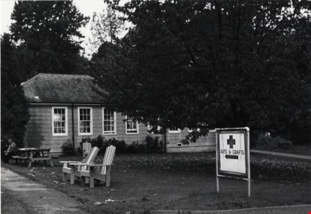
George Derby Hospital
https://search.heritageburnaby.ca/link/archivedescription79507
- Repository
- City of Burnaby Archives
- Date
- October, 1976
- Collection/Fonds
- Burnaby Public Library Contemporary Visual Archive Project
- Description Level
- Item
- Physical Description
- 1 photograph : b&w ; 11 x 16 cm mounted on cardboard
- Scope and Content
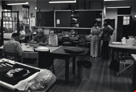
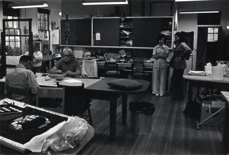
- Photograph shows the arts and crafts building at the George Derby Hospital.
- Repository
- City of Burnaby Archives
- Date
- October, 1976
- Collection/Fonds
- Burnaby Public Library Contemporary Visual Archive Project
- Physical Description
- 1 photograph : b&w ; 11 x 16 cm mounted on cardboard
- Description Level
- Item
- Record No.
- 556-334
- Access Restriction
- No restrictions
- Reproduction Restriction
- Reproduce for fair dealing purposes only
- Accession Number
- 2013-13
- Scope and Content
- Photograph shows the arts and crafts building at the George Derby Hospital.
- Subjects
- Buildings - Civic - Hospitals
- Media Type
- Photograph
- Photographer
- Salmon, Stu
- Notes
- Scope note taken directly from BPL photograph description.
- 1 b&w copy negative : 10 x 12.5 cm accompanying
- Geographic Access
- Cumberland Street
- Street Address
- 7550 Cumberland Street
- Historic Neighbourhood
- East Burnaby (Historic Neighbourhood)
- Planning Study Area
- Cariboo-Armstrong Area
Images
George Derby Hospital
https://search.heritageburnaby.ca/link/archivedescription79508
- Repository
- City of Burnaby Archives
- Date
- October, 1976
- Collection/Fonds
- Burnaby Public Library Contemporary Visual Archive Project
- Description Level
- Item
- Physical Description
- 1 photograph : b&w ; 11 x 16 cm mounted on cardboard
- Scope and Content
- Photograph shows veterans inside the arts and crafts building at the George Derby Hospital.
- Repository
- City of Burnaby Archives
- Date
- October, 1976
- Collection/Fonds
- Burnaby Public Library Contemporary Visual Archive Project
- Physical Description
- 1 photograph : b&w ; 11 x 16 cm mounted on cardboard
- Description Level
- Item
- Record No.
- 556-335
- Access Restriction
- No restrictions
- Reproduction Restriction
- Reproduce for fair dealing purposes only
- Accession Number
- 2013-13
- Scope and Content
- Photograph shows veterans inside the arts and crafts building at the George Derby Hospital.
- Subjects
- Buildings - Civic - Hospitals
- Media Type
- Photograph
- Photographer
- Salmon, Stu
- Notes
- Scope note taken directly from BPL photograph description.
- 1 b&w copy negative : 10 x 12.5 cm accompanying
- Geographic Access
- Cumberland Street
- Street Address
- 7550 Cumberland Street
- Historic Neighbourhood
- East Burnaby (Historic Neighbourhood)
- Planning Study Area
- Cariboo-Armstrong Area
Images
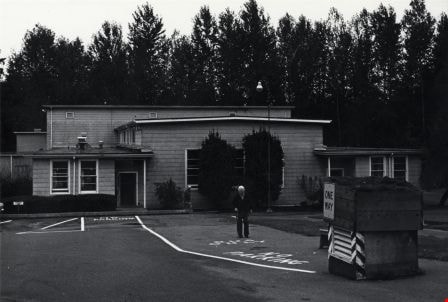
George Derby Hospital
https://search.heritageburnaby.ca/link/archivedescription79509
- Repository
- City of Burnaby Archives
- Date
- October, 1976
- Collection/Fonds
- Burnaby Public Library Contemporary Visual Archive Project
- Description Level
- Item
- Physical Description
- 1 photograph : b&w ; 11 x 16 cm mounted on cardboard
- Scope and Content
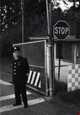
- Photograph shows gate attendant at the entrance to the George Derby Hospital.
- Repository
- City of Burnaby Archives
- Date
- October, 1976
- Collection/Fonds
- Burnaby Public Library Contemporary Visual Archive Project
- Physical Description
- 1 photograph : b&w ; 11 x 16 cm mounted on cardboard
- Description Level
- Item
- Record No.
- 556-336
- Access Restriction
- No restrictions
- Reproduction Restriction
- Reproduce for fair dealing purposes only
- Accession Number
- 2013-13
- Scope and Content
- Photograph shows gate attendant at the entrance to the George Derby Hospital.
- Subjects
- Buildings - Civic - Hospitals
- Media Type
- Photograph
- Photographer
- Salmon, Stu
- Notes
- Scope note taken directly from BPL photograph description.
- 1 b&w copy negative : 10 x 12.5 cm accompanying
- Geographic Access
- Cumberland Street
- Street Address
- 7550 Cumberland Street
- Historic Neighbourhood
- East Burnaby (Historic Neighbourhood)
- Planning Study Area
- Cariboo-Armstrong Area
Images

![Girl in gateway, [between 1912 and 1925] thumbnail](/media/hpo/_Data/_BVM_Images/1984/1984_0051_0028_001.jpg?width=280)
Girl in gateway
https://search.heritageburnaby.ca/link/museumdescription256
- Repository
- Burnaby Village Museum
- Date
- [between 1912 and 1925]
- Collection/Fonds
- Burnaby Village Museum Photograph collection
- Description Level
- Item
- Physical Description
- 1 photograph : b&w ; 9.8 x 7.2 cm
- Scope and Content
- Photograph of a girl in a dress tied at the waist with a white collar at the neck. She is wearing boots and a straw hat, and is standing by the gateway in a log fence. There is a cobblestone path way on which she is standing, and there are woods in the distance in the background. According to the a…
- Repository
- Burnaby Village Museum
- Collection/Fonds
- Burnaby Village Museum Photograph collection
- Description Level
- Item
- Physical Description
- 1 photograph : b&w ; 9.8 x 7.2 cm
- Scope and Content
- Photograph of a girl in a dress tied at the waist with a white collar at the neck. She is wearing boots and a straw hat, and is standing by the gateway in a log fence. There is a cobblestone path way on which she is standing, and there are woods in the distance in the background. According to the accession register, the location is at Buena Vista, Burnaby, between 1912 and 1925.
- Subjects
- Structures - Fences
- Accession Code
- HV984.51.28
- Access Restriction
- No restrictions
- Reproduction Restriction
- No known restrictions
- Date
- [between 1912 and 1925]
- Media Type
- Photograph
- Historic Neighbourhood
- East Burnaby (Historic Neighbourhood)
- Planning Study Area
- Cariboo-Armstrong Area
- Scan Resolution
- 600
- Scan Date
- 2023-10-10
- Notes
- Title based on contents of photograph
Images
![Girl in gateway, [between 1912 and 1925] thumbnail](/media/hpo/_Data/_BVM_Images/1984/1984_0051_0028_001.jpg)
![Girls in front of Jesse Love farmhouse, [192-] thumbnail](/media/hpo/_Data/_BVM_Images/2022/2022_0032_0389_001.jpg?width=280)
Girls in front of Jesse Love farmhouse
https://search.heritageburnaby.ca/link/museumdescription19967
- Repository
- Burnaby Village Museum
- Date
- [192-]
- Collection/Fonds
- Esther Love Stanley fonds
- Description Level
- Item
- Physical Description
- 1 photograph : b&w ; 7 x 11 cm
- Scope and Content
- Photograph of two adolescent aged girls standing in the garden of the Jesse and Martha Love farmhouse. Farmhouse and garden are visible behind the girls. Flowering plants and vines are growing on the fence and the porch of the house. Both girls are wearing eye glasses.
- Repository
- Burnaby Village Museum
- Collection/Fonds
- Esther Love Stanley fonds
- Description Level
- Item
- Physical Description
- 1 photograph : b&w ; 7 x 11 cm
- Scope and Content
- Photograph of two adolescent aged girls standing in the garden of the Jesse and Martha Love farmhouse. Farmhouse and garden are visible behind the girls. Flowering plants and vines are growing on the fence and the porch of the house. Both girls are wearing eye glasses.
- Subjects
- Persons - Adolescents
- Geographic Access
- Cumberland Street
- Street Address
- 7651 Cumberland Street
- Accession Code
- BV022.32.389
- Access Restriction
- No restrictions
- Reproduction Restriction
- No known restrictions
- Date
- [192-]
- Media Type
- Photograph
- Historic Neighbourhood
- East Burnaby (Historic Neighbourhood)
- Planning Study Area
- Cariboo-Armstrong Area
- Scan Resolution
- 600
- Scan Date
- 2023-06-13
- Notes
- Title based on contents of photograph
- Photograph is part of Esther Love Stanley photograph album 1 (BV022.32.1)
Images
![Girls in front of Jesse Love farmhouse, [192-] thumbnail](/media/hpo/_Data/_BVM_Images/2022/2022_0032_0389_001.jpg)
![Goodlad Street house, [1955] (date of original), copied 1991 thumbnail](/media/hpo/_Data/_Archives_Images/_Unrestricted/370/370-355.jpg?width=280)
Goodlad Street house
https://search.heritageburnaby.ca/link/archivedescription37767
- Repository
- City of Burnaby Archives
- Date
- [1955] (date of original), copied 1991
- Collection/Fonds
- Burnaby Historical Society fonds
- Description Level
- Item
- Physical Description
- 1 photograph : b&w ; 3.1 x 3.0 cm print on contact sheet 20.3 x 26.2 cm
- Scope and Content
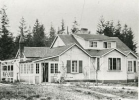
- Photograph of a home on Goodlad Street, address unknown. The house has just been finished and the yard has yet to be landscaped.
- Repository
- City of Burnaby Archives
- Date
- [1955] (date of original), copied 1991
- Collection/Fonds
- Burnaby Historical Society fonds
- Subseries
- Burnaby Image Bank subseries
- Physical Description
- 1 photograph : b&w ; 3.1 x 3.0 cm print on contact sheet 20.3 x 26.2 cm
- Description Level
- Item
- Record No.
- 370-355
- Access Restriction
- No restrictions
- Reproduction Restriction
- No restrictions
- Accession Number
- BHS1999-03
- Scope and Content
- Photograph of a home on Goodlad Street, address unknown. The house has just been finished and the yard has yet to be landscaped.
- Subjects
- Buildings - Residential - Houses
- Media Type
- Photograph
- Notes
- Title based on contents of photograph
- 1 b&w copy negative accompanying
- Negative has a pink cast
- Geographic Access
- Goodlad Street
- Historic Neighbourhood
- East Burnaby (Historic Neighbourhood)
- Planning Study Area
- Lakeview-Mayfield Area
Images
![Goodlad Street house, [1955] (date of original), copied 1991 thumbnail](/media/hpo/_Data/_Archives_Images/_Unrestricted/370/370-355.jpg)
Hawkshaw family home
https://search.heritageburnaby.ca/link/archivedescription35164
- Repository
- City of Burnaby Archives
- Date
- 1927 (date of original), copied 1986
- Collection/Fonds
- Burnaby Historical Society fonds
- Description Level
- Item
- Physical Description
- 1 photograph : b&w ; 12.7 x 17.8 cm print
- Scope and Content
- Photograph of the Hawkshaw family home, 763 Wedgewood Street (later renumbered 7743 Wedgewood Street), East Burnaby. The Hawkshaw family lived here between 1920 and 1929. Mabel Hawkshaw and her son, Cedric, are outside.
- Repository
- City of Burnaby Archives
- Date
- 1927 (date of original), copied 1986
- Collection/Fonds
- Burnaby Historical Society fonds
- Subseries
- Pioneer Tales subseries
- Physical Description
- 1 photograph : b&w ; 12.7 x 17.8 cm print
- Description Level
- Item
- Record No.
- 204-021
- Access Restriction
- No restrictions
- Reproduction Restriction
- No known restrictions
- Accession Number
- BHS1988-03
- Scope and Content
- Photograph of the Hawkshaw family home, 763 Wedgewood Street (later renumbered 7743 Wedgewood Street), East Burnaby. The Hawkshaw family lived here between 1920 and 1929. Mabel Hawkshaw and her son, Cedric, are outside.
- Subjects
- Buildings - Residential - Houses
- Media Type
- Photograph
- Notes
- Title based on contents of photograph
- Geographic Access
- Wedgewood Street
- Street Address
- 7743 Wedgewood Street
- Historic Neighbourhood
- East Burnaby (Historic Neighbourhood)
- Planning Study Area
- Lakeview-Mayfield Area
Images

House at 7945 12th Avenue
https://search.heritageburnaby.ca/link/archivedescription78890
- Repository
- City of Burnaby Archives
- Date
- February 7, 1977
- Collection/Fonds
- Burnaby Public Library Contemporary Visual Archive Project
- Description Level
- Item
- Physical Description
- 1 photograph : b&w ; 11 x 16 cm mounted on cardboard
- Scope and Content
- Photograph shows the house at 7945 12th Avenue.
- Repository
- City of Burnaby Archives
- Date
- February 7, 1977
- Collection/Fonds
- Burnaby Public Library Contemporary Visual Archive Project
- Physical Description
- 1 photograph : b&w ; 11 x 16 cm mounted on cardboard
- Description Level
- Item
- Record No.
- 556-016
- Access Restriction
- No restrictions
- Reproduction Restriction
- Reproduce for fair dealing purposes only
- Accession Number
- 2013-13
- Scope and Content
- Photograph shows the house at 7945 12th Avenue.
- Media Type
- Photograph
- Notes
- Scope note taken directly from BPL photograph description.
- 1 b&w copy negative : 10 x 12.5 cm accompanying
- Photographers identified by surnames only: Carr and Vardeman
- Geographic Access
- 12th Avenue
- Street Address
- 7945 12th Avenue
- Historic Neighbourhood
- East Burnaby (Historic Neighbourhood)
- Planning Study Area
- Second Street Area
Images

House at 9113 Mona Avenue
https://search.heritageburnaby.ca/link/archivedescription78957
- Repository
- City of Burnaby Archives
- Date
- October,1976
- Collection/Fonds
- Burnaby Public Library Contemporary Visual Archive Project
- Description Level
- Item
- Physical Description
- 1 photograph : b&w ; 11 x 16 cm mounted on cardboard
- Scope and Content
- Photograph shows a house at 9113 Mona Avenue, built in 1952.
- Repository
- City of Burnaby Archives
- Date
- October,1976
- Collection/Fonds
- Burnaby Public Library Contemporary Visual Archive Project
- Physical Description
- 1 photograph : b&w ; 11 x 16 cm mounted on cardboard
- Description Level
- Item
- Record No.
- 556-050
- Access Restriction
- No restrictions
- Reproduction Restriction
- Reproduce for fair dealing purposes only
- Accession Number
- 2013-13
- Scope and Content
- Photograph shows a house at 9113 Mona Avenue, built in 1952.
- Media Type
- Photograph
- Photographer
- Salmon, Stu
- Notes
- Scope note taken directly from BPL photograph description.
- 1 b&w copy negative : 10 x 12.5 cm accompanying
- Geographic Access
- Mona Avenue
- Street Address
- 9113 Mona Avenue
- Historic Neighbourhood
- East Burnaby (Historic Neighbourhood)
- Planning Study Area
- Cariboo-Armstrong Area
Images
![House at Buena Vista, [between 1912 and 1925] thumbnail](/media/hpo/_Data/_BVM_Images/1984/1984_0051_0017_001.jpg?width=280)
House at Buena Vista
https://search.heritageburnaby.ca/link/museumdescription245
- Repository
- Burnaby Village Museum
- Date
- [between 1912 and 1925]
- Collection/Fonds
- Burnaby Village Museum Photograph collection
- Description Level
- Item
- Physical Description
- 1 photograph : b&w ; 7.2 x 9.7 cm
- Scope and Content
- Photograph of a house with a large porch and a log fence with a gateway in the centre. There is a cobblestone pathway, and two women and a man, standing on the porch. According to the accession register, the location of the house is at Buena Vista, Burnaby, between 1912 and 1925.
- Repository
- Burnaby Village Museum
- Collection/Fonds
- Burnaby Village Museum Photograph collection
- Description Level
- Item
- Physical Description
- 1 photograph : b&w ; 7.2 x 9.7 cm
- Scope and Content
- Photograph of a house with a large porch and a log fence with a gateway in the centre. There is a cobblestone pathway, and two women and a man, standing on the porch. According to the accession register, the location of the house is at Buena Vista, Burnaby, between 1912 and 1925.
- Subjects
- Buildings - Residential - Houses
- Accession Code
- HV984.51.17
- Access Restriction
- No restrictions
- Reproduction Restriction
- May be restricted by third party rights
- Date
- [between 1912 and 1925]
- Media Type
- Photograph
- Historic Neighbourhood
- East Burnaby (Historic Neighbourhood)
- Planning Study Area
- Cariboo-Armstrong Area
- Related Material
- To see another photograph of the house, see HV984.51.19 and .29
- Scan Resolution
- 600
- Scan Date
- 2023-10-10
- Notes
- Title based on contents of photograph
Images
![House at Buena Vista, [between 1912 and 1925] thumbnail](/media/hpo/_Data/_BVM_Images/1984/1984_0051_0017_001.jpg)
![House at Buena Vista, Burnaby, [between 1912 and 1925] thumbnail](/media/hpo/_Data/_BVM_Images/1984/1984_0051_0019_001.jpg?width=280)
House at Buena Vista, Burnaby
https://search.heritageburnaby.ca/link/museumdescription247
- Repository
- Burnaby Village Museum
- Date
- [between 1912 and 1925]
- Collection/Fonds
- Burnaby Village Museum Photograph collection
- Description Level
- Item
- Physical Description
- 1 photograph : sepia ; 11.4 x 7.0 cm
- Scope and Content
- Photograph of a house with a large porch area. The house looks like it was renovated with a window put in on the second floor, The stairs, patio and the lawn in front are covered in snow. According to the accession register, the location of the house is at Buena Vista, Burnaby, between 1912 and 192…
- Repository
- Burnaby Village Museum
- Collection/Fonds
- Burnaby Village Museum Photograph collection
- Description Level
- Item
- Physical Description
- 1 photograph : sepia ; 11.4 x 7.0 cm
- Scope and Content
- Photograph of a house with a large porch area. The house looks like it was renovated with a window put in on the second floor, The stairs, patio and the lawn in front are covered in snow. According to the accession register, the location of the house is at Buena Vista, Burnaby, between 1912 and 1925.
- Accession Code
- HV984.51.19
- Access Restriction
- No restrictions
- Reproduction Restriction
- No known restrictions
- Date
- [between 1912 and 1925]
- Media Type
- Photograph
- Historic Neighbourhood
- East Burnaby (Historic Neighbourhood)
- Planning Study Area
- Cariboo-Armstrong Area
- Related Material
- To see another photograph of the house, see HV984.51.17 and .29
- Scan Resolution
- 600
- Scan Date
- 2023-10-10
- Notes
- Title based on contents of photograph
Images
![House at Buena Vista, Burnaby, [between 1912 and 1925] thumbnail](/media/hpo/_Data/_BVM_Images/1984/1984_0051_0019_001.jpg)