Narrow Results By

1982 - Moving the Roberts House
https://search.heritageburnaby.ca/link/archivedescription91880
- Repository
- City of Burnaby Archives
- Date
- 1982
- Collection/Fonds
- Small family fonds
- Description Level
- Item
- Physical Description
- 1 photograph : col. copy print ; 10 cm x 15 cm
- Scope and Content
- Photograph of the land being cleared at 5496 Dominion Street in order to create a path to move the Roberts' house onto the property. Included in the clearing are the stumps of two apples trees, a poplar tree, and a maple tree. The debris from the site was burned and smoke can seen rising from a s…
- Repository
- City of Burnaby Archives
- Date
- 1982
- Collection/Fonds
- Small family fonds
- Physical Description
- 1 photograph : col. copy print ; 10 cm x 15 cm
- Description Level
- Item
- Record No.
- 620-061
- Access Restriction
- No restrictions
- Reproduction Restriction
- No reproduction permitted
- Accession Number
- 2017-01
- Scope and Content
- Photograph of the land being cleared at 5496 Dominion Street in order to create a path to move the Roberts' house onto the property. Included in the clearing are the stumps of two apples trees, a poplar tree, and a maple tree. The debris from the site was burned and smoke can seen rising from a small pile of brush on the right.
- Media Type
- Photograph
- Notes
- Transcribed title
- Title transcribed from donor's notes
- Note in blue ink on verso of photograph reads: "p.3"
- Note in pencil on verso of photograph reads: "2"
- Street Address
- 5496 Dominion Street
- Historic Neighbourhood
- Burnaby Lake (Historic Neighbourhood)
- Planning Study Area
- Ardingley-Sprott Area
Images


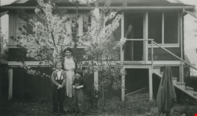
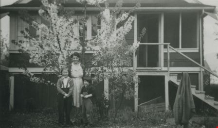
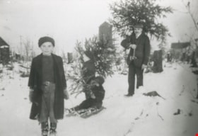
1982 - Moving the Roberts House 5538 Dominion Street to its new location at 5496 Dominion Street
https://search.heritageburnaby.ca/link/archivedescription91879
- Repository
- City of Burnaby Archives
- Date
- 1982
- Collection/Fonds
- Small family fonds
- Description Level
- Item
- Physical Description
- 1 photograph : col. ; 9 cm x 13 cm
- Scope and Content
- Photograph of the site at 5496 Dominion Street where the Roberts' house was to be moved. To the left is the old garage that was originally part of the small dwelling the Roberts lived in during the construction of their house in the early 1920s. In the background is 3093 Douglas Road and in the f…
- Repository
- City of Burnaby Archives
- Date
- 1982
- Collection/Fonds
- Small family fonds
- Physical Description
- 1 photograph : col. ; 9 cm x 13 cm
- Description Level
- Item
- Record No.
- 620-060
- Access Restriction
- No restrictions
- Reproduction Restriction
- No reproduction permitted
- Accession Number
- 2017-01
- Scope and Content
- Photograph of the site at 5496 Dominion Street where the Roberts' house was to be moved. To the left is the old garage that was originally part of the small dwelling the Roberts lived in during the construction of their house in the early 1920s. In the background is 3093 Douglas Road and in the foreground are two apple trees planted by John W. Roberts.
- Media Type
- Photograph
- Notes
- Transcribed title
- Title transcribed from donor's notes
- Note in blue ink on verso of photograph reads: "p.2"
- Note in blue ink on verso of photograph reads: "Garage, Poplar Tree and Apple Trees before they had to go to make room to move house here / Spring 1982"
- 5118 Douglas Road renumbered to 3131 Douglas Road in 1958 and to 5538 Dominion Street in 1970 or 1971
- Street Address
- 5496 Dominion Street
- Historic Neighbourhood
- Burnaby Lake (Historic Neighbourhood)
- Planning Study Area
- Ardingley-Sprott Area
Images


6742 Walker Avenue
https://search.heritageburnaby.ca/link/archivedescription37844
- Repository
- City of Burnaby Archives
- Date
- May 1987 (date of original), copied 1991
- Collection/Fonds
- Burnaby Historical Society fonds
- Description Level
- Item
- Physical Description
- 1 photograph : b&w ; 3.1 x 4.3 cm print on contact sheet 20.6 x 26.7 cm
- Scope and Content
- Photograph of 6742 Walker Avenue, with only the trees in the yard visible from the road. A van is parked in front.
- Repository
- City of Burnaby Archives
- Date
- May 1987 (date of original), copied 1991
- Collection/Fonds
- Burnaby Historical Society fonds
- Subseries
- Burnaby Image Bank subseries
- Physical Description
- 1 photograph : b&w ; 3.1 x 4.3 cm print on contact sheet 20.6 x 26.7 cm
- Description Level
- Item
- Record No.
- 370-432
- Access Restriction
- No restrictions
- Reproduction Restriction
- No restrictions
- Accession Number
- BHS1999-03
- Scope and Content
- Photograph of 6742 Walker Avenue, with only the trees in the yard visible from the road. A van is parked in front.
- Subjects
- Plants - Trees
- Media Type
- Photograph
- Notes
- Title based on contents of photograph
- 1 b&w copy negative accompanying
- Negative has a pink cast
- Copied from col. photograph
- Geographic Access
- Walker Avenue
- Street Address
- 6742 Walker Avenue
- Historic Neighbourhood
- Edmonds (Historic Neighbourhood)
- Planning Study Area
- Richmond Park Area
Images


6742 Walker Avenue
https://search.heritageburnaby.ca/link/archivedescription37845
- Repository
- City of Burnaby Archives
- Date
- May 1987 (date of original), copied 1991
- Collection/Fonds
- Burnaby Historical Society fonds
- Description Level
- Item
- Physical Description
- 1 photograph : b&w ; 3.0 x 4.4 cm print on contact sheet 20.6 x 26.7 cm
- Scope and Content
- Photograph of 6742 Walker Avenue with some of the trees in the yard cut down.
- Repository
- City of Burnaby Archives
- Date
- May 1987 (date of original), copied 1991
- Collection/Fonds
- Burnaby Historical Society fonds
- Subseries
- Burnaby Image Bank subseries
- Physical Description
- 1 photograph : b&w ; 3.0 x 4.4 cm print on contact sheet 20.6 x 26.7 cm
- Description Level
- Item
- Record No.
- 370-433
- Access Restriction
- No restrictions
- Reproduction Restriction
- No restrictions
- Accession Number
- BHS1999-03
- Scope and Content
- Photograph of 6742 Walker Avenue with some of the trees in the yard cut down.
- Subjects
- Plants - Trees
- Media Type
- Photograph
- Notes
- Title based on contents of photograph
- 1 b&w copy negative accompanying
- Negative has a pink cast
- Copied from col. photograph
- Geographic Access
- Walker Avenue
- Street Address
- 6742 Walker Avenue
- Historic Neighbourhood
- Edmonds (Historic Neighbourhood)
- Planning Study Area
- Richmond Park Area
Images


6742 Walker Avenue
https://search.heritageburnaby.ca/link/archivedescription37846
- Repository
- City of Burnaby Archives
- Date
- May 1987 (date of original), copied 1991
- Collection/Fonds
- Burnaby Historical Society fonds
- Description Level
- Item
- Physical Description
- 1 photograph : b&w ; 3.0 x 4.3 cm print on contact sheet 20.6 x 26.7 cm
- Scope and Content
- Photograph of 6742 Walker Avenue, showing the stumps of the recently cut down trees in the yard of the house.
- Repository
- City of Burnaby Archives
- Date
- May 1987 (date of original), copied 1991
- Collection/Fonds
- Burnaby Historical Society fonds
- Subseries
- Burnaby Image Bank subseries
- Physical Description
- 1 photograph : b&w ; 3.0 x 4.3 cm print on contact sheet 20.6 x 26.7 cm
- Description Level
- Item
- Record No.
- 370-434
- Access Restriction
- No restrictions
- Reproduction Restriction
- No restrictions
- Accession Number
- BHS1999-03
- Scope and Content
- Photograph of 6742 Walker Avenue, showing the stumps of the recently cut down trees in the yard of the house.
- Media Type
- Photograph
- Notes
- Title based on contents of photograph
- 1 b&w copy negative accompanying
- Negative has a pink cast
- Copied from col. photograph
- Geographic Access
- Walker Avenue
- Street Address
- 6742 Walker Avenue
- Historic Neighbourhood
- Edmonds (Historic Neighbourhood)
- Planning Study Area
- Richmond Park Area
Images


Alfred Bingham
https://search.heritageburnaby.ca/link/archivedescription34149
- Repository
- City of Burnaby Archives
- Date
- April 20, 1947
- Collection/Fonds
- Burnaby Historical Society fonds
- Description Level
- Item
- Physical Description
- 1 photograph : b&w negative ; 11.3 x 6.8 cm
- Scope and Content
- Photograph of Alfred "Alf" Bingham standing in front of a fir tree stump that is approximately 400 years old on the 4200 block of Kitchener Street. This is part of the Willingdon Heights subdivision site.
- Repository
- City of Burnaby Archives
- Date
- April 20, 1947
- Collection/Fonds
- Burnaby Historical Society fonds
- Subseries
- Alfred Bingham subseries
- Physical Description
- 1 photograph : b&w negative ; 11.3 x 6.8 cm
- Description Level
- Item
- Record No.
- 010-066
- Access Restriction
- No restrictions
- Reproduction Restriction
- Reproduce for fair dealing purposes only
- Accession Number
- BHS2007-04
- Scope and Content
- Photograph of Alfred "Alf" Bingham standing in front of a fir tree stump that is approximately 400 years old on the 4200 block of Kitchener Street. This is part of the Willingdon Heights subdivision site.
- Subjects
- Land Clearing
- Plants - Trees
- Names
- Bingham, Alfred "Alf"
- Media Type
- Photograph
- Photographer
- Bingham, Alfred "Alf"
- Notes
- Title based on contents of photograph
- Geographic Access
- Kitchener Street
Images


Alfred Bingham's writings - Track 9
https://search.heritageburnaby.ca/link/oralhistory259
- Repository
- City of Burnaby Archives
- Date Range
- 1919-1939
- Length
- 0:07:31
- Summary
- This portion of the recording includes Alfred Bingham's continuation of reading his series of short stories. He reads; "The ICE AGE and other observations before Burnaby", "The Coming of the Great Trees in Burnaby", "AND THEN MODERN CIVILIZATION STRUCK BURNABY" each written in March of 1962.
- Repository
- City of Burnaby Archives
- Summary
- This portion of the recording includes Alfred Bingham's continuation of reading his series of short stories. He reads; "The ICE AGE and other observations before Burnaby", "The Coming of the Great Trees in Burnaby", "AND THEN MODERN CIVILIZATION STRUCK BURNABY" each written in March of 1962.
- Date Range
- 1919-1939
- Photo Info
- Alfred Bingham, April 20, 1947. Item no. 010-066
- Length
- 0:07:31
- Subjects
- Plants - Trees
- Scope and Content
- Recording is of Alfred Bingham's writings, as read by Alfred Bingham. Major themes discussed are: Pioneers, early days in Burnaby and the Co-op Movement. To view "Narrow By" terms for each track expand this description and see "Notes".
- Biographical Notes
- Alfred "Alf" Bingham was born in England in 1892 and moved to Canada in 1912. His first job in Canada was laying track for the Grand Trunk Pacific Railway (GTPR) from Edmonton to McBride in 1912. His second was in Vancouver at the Rat Portage Mill on False Creek, working on the Resaw machine. He quit after one week due to poor working conditions. After taking part in the 1919 Winnipeg General Strike as a delegate of the Retail and Mailorder Union (A.F.L.) on the Winnipeg Trades and Labour Council, Alfred moved to Burnaby where he and fellow Burnaby residents Aungus McLean and Percy Little worked ten hour days to build a Shingle Mill on the edge of Burnaby Lake for Simpson & Giberson. George Green, carpenter and millwright (author of “The History of Burnaby”) also helped in the construction of the mill. Alfred built his own home from lumber cut from the mill in the Lochdale area on Sherlock Street between Curtis Street and Kitchener Street. On April 10, 1920 Alfred married Mary Jane “Ada” Reynolds. Alfred and Ada often took in foster children during their marriage. Due to her nursing experience, Ada was often called upon to deliver babies in the Burnaby area. Alfred and Ada Bingham were instrumental members of the Army of the Common Good, collecting vegetables and grains from growers in the area and even producing over 125 tons of vegetables from its own gardens to feed children and youth suffering from the lack of resources during the Depression years. The army was in operation for ten years and during that time the members organised the Credit Union movement of British Columbia and drew up the Credit Union act thorough the Vancouver Co-operative Council. They also started Co-Op stores and the Co-Op Wholesale Society. Alfred was also Secretary of the Burnaby Housing committee and in 1946 he became the Secretary of the North Burnaby Labour Progressive Party (LPP). Mary Jane “Ada” (Reynolds) Bingham died on August 9, 1969. Her husband Alfred died on April 29, 1979.
- Total Tracks
- 12
- Total Length
- 1:38:06
- Interviewee Name
- Bingham, Alfred "Alf"
- Collection/Fonds
- Burnaby Historical Society fonds
- Subseries
- Oral history subseries
- Transcript Available
- MSS142-001 contains transcripts for each of the short stories
- Media Type
- Sound Recording
- Web Notes
- Interview was digitized in 2010 allowing it to be accessible on Heritage Burnaby. The digitization project was initiated by the Community Heritage Commission with support from City of Burnaby Council and the BC History Digitization Program of the Irving K. Barber Learning Centre, University of British Columbia. It was recognized by the Heritage Society of BC with an award in 2012.
Images

Audio Tracks
Track nine of recording of Alfred Bingham's writings
Track nine of recording of Alfred Bingham's writings
https://search.heritageburnaby.ca/media/hpo/_Data/_Archives_Oral_Histories/_Unrestricted/100-13-20-2/100-13-20-2_Track_9.mp3
Allanson family clearing land
https://search.heritageburnaby.ca/link/archivedescription35793
- Repository
- City of Burnaby Archives
- Date
- 1923 (date of original), copied 1986
- Collection/Fonds
- Burnaby Historical Society fonds
- Description Level
- Item
- Physical Description
- 1 photograph : b&w ; 12.7 x 17.8 cm print
- Scope and Content
- Photograph of the Allanson family clearing the land at 12 Warwick Avenue bought by Malcolm and Mabel Allanson. Left to right: William Allanson, Mabel Allanson, Malcolm Allanson, and Jessie Allanson. William and Jessie Allanson are the parents of Malcolm. Mabel and Malcolm Allanson are married.
- Repository
- City of Burnaby Archives
- Date
- 1923 (date of original), copied 1986
- Collection/Fonds
- Burnaby Historical Society fonds
- Subseries
- Pioneer Tales subseries
- Physical Description
- 1 photograph : b&w ; 12.7 x 17.8 cm print
- Description Level
- Item
- Record No.
- 204-651
- Access Restriction
- No restrictions
- Reproduction Restriction
- No known restrictions
- Accession Number
- BHS1988-03
- Scope and Content
- Photograph of the Allanson family clearing the land at 12 Warwick Avenue bought by Malcolm and Mabel Allanson. Left to right: William Allanson, Mabel Allanson, Malcolm Allanson, and Jessie Allanson. William and Jessie Allanson are the parents of Malcolm. Mabel and Malcolm Allanson are married.
- Subjects
- Land Clearing
- Plants - Trees
- Media Type
- Photograph
- Notes
- Title based on contents of photograph
- Geographic Access
- Warwick Avenue
- Street Address
- 12 Warwick Avenue
- Historic Neighbourhood
- Capitol Hill (Historic Neighbourhood)
- Planning Study Area
- Capitol Hill Area
Images

Allen family
https://search.heritageburnaby.ca/link/archivedescription36794
- Repository
- City of Burnaby Archives
- Date
- 1940 (date of original), copied 1992
- Collection/Fonds
- Burnaby Historical Society fonds
- Description Level
- Item
- Physical Description
- 1 photograph : b&w ; 7.4 x 12.3 cm print
- Scope and Content
- Photograph of the Allen family mother and daughters in front of a blossoming tree. Left to right: Pat, Marjorie (mother) and Stephanie. This photograph was taken at their home at 3976 McGill Street.
- Repository
- City of Burnaby Archives
- Date
- 1940 (date of original), copied 1992
- Collection/Fonds
- Burnaby Historical Society fonds
- Subseries
- Burnaby Centennial Anthology subseries
- Physical Description
- 1 photograph : b&w ; 7.4 x 12.3 cm print
- Description Level
- Item
- Record No.
- 315-251
- Access Restriction
- No restrictions
- Reproduction Restriction
- No known restrictions
- Accession Number
- BHS1994-04
- Scope and Content
- Photograph of the Allen family mother and daughters in front of a blossoming tree. Left to right: Pat, Marjorie (mother) and Stephanie. This photograph was taken at their home at 3976 McGill Street.
- Media Type
- Photograph
- Notes
- Title based on contents of photograph
- Geographic Access
- McGill Street
- Street Address
- 3976 McGill Street
- Historic Neighbourhood
- Vancouver Heights (Historic Neighbourhood)
- Planning Study Area
- Burnaby Heights Area
Images

Annie Eshelby in front of a felled tree
https://search.heritageburnaby.ca/link/archivedescription35363
- Repository
- City of Burnaby Archives
- Date
- 1924
- Collection/Fonds
- Burnaby Historical Society fonds
- Description Level
- Item
- Physical Description
- 1 photograph : b&w ; 12.7 x 17.8 cm print
- Scope and Content
- Photograph of Mrs. Annie Eshelby in front of a felled tree measuring six feet in diameter. She is sitting on a chair with a black and white cat lying across her lap. This photograph was taken at the lot on Fell Avenue and Dundas Street, North Burnaby, which was cleared for the Eshelby family home. …
- Repository
- City of Burnaby Archives
- Date
- 1924
- Collection/Fonds
- Burnaby Historical Society fonds
- Subseries
- Pioneer Tales subseries
- Physical Description
- 1 photograph : b&w ; 12.7 x 17.8 cm print
- Description Level
- Item
- Record No.
- 204-220
- Access Restriction
- No restrictions
- Reproduction Restriction
- No known restrictions
- Accession Number
- BHS1988-03
- Scope and Content
- Photograph of Mrs. Annie Eshelby in front of a felled tree measuring six feet in diameter. She is sitting on a chair with a black and white cat lying across her lap. This photograph was taken at the lot on Fell Avenue and Dundas Street, North Burnaby, which was cleared for the Eshelby family home. Annie Eshelby (nee Perrey) was married to Frank Eshelby. They settled in Burnaby after moving from England in 1922.
- Subjects
- Animals - Cats
- Land Clearing
- Plants - Trees
- Names
- Eshelby, Annie Perrey
- Media Type
- Photograph
- Notes
- Title based on contents of photograph
- Geographic Access
- Fell Avenue
- Dundas Street
- Historic Neighbourhood
- Capitol Hill (Historic Neighbourhood)
- Planning Study Area
- Capitol Hill Area
Images

![Blasting stump, [1921 or 1922] (date of original), digitally copied 2012 thumbnail](/media/hpo/_Data/_Archives_Images/_Unrestricted/540/549-008.jpg?width=280)
Blasting stump
https://search.heritageburnaby.ca/link/archivedescription76891
- Repository
- City of Burnaby Archives
- Date
- [1921 or 1922] (date of original), digitally copied 2012
- Collection/Fonds
- Community Heritage Commission Special Projects fonds
- Description Level
- Item
- Physical Description
- 1 photograph (jpeg) : col. ; 300ppi
- Scope and Content
- Photograph of members of the Brown-John family sitting and standing on the blasting stump. This stump was located near the corner of Gilmore Avenue and Napier Street.
- Repository
- City of Burnaby Archives
- Date
- [1921 or 1922] (date of original), digitally copied 2012
- Collection/Fonds
- Community Heritage Commission Special Projects fonds
- Physical Description
- 1 photograph (jpeg) : col. ; 300ppi
- Description Level
- Item
- Record No.
- 549-008
- Access Restriction
- No restrictions
- Reproduction Restriction
- No known restrictions
- Accession Number
- 2012-30
- Scope and Content
- Photograph of members of the Brown-John family sitting and standing on the blasting stump. This stump was located near the corner of Gilmore Avenue and Napier Street.
- Subjects
- Plants - Trees
- Names
- Brown-John, Victor Joseph Charles
- Brown-John, Archie
- Brown-John, Frank
- Brown-John, Roy
- Ansdell, Elsie Brown-John
- Brown-John, Clive
- Media Type
- Photograph
- Notes
- Title based on contents of photograph
- Geographic Access
- Gilmore Avenue
- Napier Street
- Historic Neighbourhood
- Vancouver Heights (Historic Neighbourhood)
- Planning Study Area
- Willingdon Heights Area
Images
![Blasting stump, [1921 or 1922] (date of original), digitally copied 2012 thumbnail](/media/hpo/_Data/_Archives_Images/_Unrestricted/540/549-008.jpg)
![Blasting stump, [1920] (date of original), digitally copied 2012 thumbnail](/media/hpo/_Data/_Archives_Images/_Unrestricted/540/549-009.jpg?width=280)
Blasting stump
https://search.heritageburnaby.ca/link/archivedescription76892
- Repository
- City of Burnaby Archives
- Date
- [1920] (date of original), digitally copied 2012
- Collection/Fonds
- Community Heritage Commission Special Projects fonds
- Description Level
- Item
- Physical Description
- 1 photograph (jpeg) : col. ; 300ppi
- Scope and Content
- Photograph of the Brown-John children playing on the blasting stump that was located near the corner of Gilmore Avenue and Napier Street.
- Repository
- City of Burnaby Archives
- Date
- [1920] (date of original), digitally copied 2012
- Collection/Fonds
- Community Heritage Commission Special Projects fonds
- Physical Description
- 1 photograph (jpeg) : col. ; 300ppi
- Description Level
- Item
- Record No.
- 549-009
- Access Restriction
- No restrictions
- Reproduction Restriction
- No known restrictions
- Accession Number
- 2012-30
- Scope and Content
- Photograph of the Brown-John children playing on the blasting stump that was located near the corner of Gilmore Avenue and Napier Street.
- Subjects
- Plants - Trees
- Media Type
- Photograph
- Notes
- Title based on contents of photograph
- Geographic Access
- Gilmore Avenue
- Napier Street
- Historic Neighbourhood
- Vancouver Heights (Historic Neighbourhood)
- Planning Study Area
- Willingdon Heights Area
Images
![Blasting stump, [1920] (date of original), digitally copied 2012 thumbnail](/media/hpo/_Data/_Archives_Images/_Unrestricted/540/549-009.jpg)

Burnaby Lake
https://search.heritageburnaby.ca/link/archivedescription91701
- Repository
- City of Burnaby Archives
- Date
- March 1982 - April 1982
- Collection/Fonds
- Doreen Lawson fonds
- Description Level
- File
- Physical Description
- 17 photographs : col. slides ; 35 mm
- Scope and Content
- File consists photographs of Burnaby Lake taken in late winter. The foliage around the lake is primarily brown and wilted with the first new growth of Spring just emerging. Canadian geese swim on the lake in the foreground of several of the photographs, with snow-covered mountains and the Loughee…
- Repository
- City of Burnaby Archives
- Date
- March 1982 - April 1982
- Collection/Fonds
- Doreen Lawson fonds
- Physical Description
- 17 photographs : col. slides ; 35 mm
- Description Level
- File
- Record No.
- 618-019
- Access Restriction
- No restrictions
- Reproduction Restriction
- No restrictions
- Accession Number
- 2015-15
- Scope and Content
- File consists photographs of Burnaby Lake taken in late winter. The foliage around the lake is primarily brown and wilted with the first new growth of Spring just emerging. Canadian geese swim on the lake in the foreground of several of the photographs, with snow-covered mountains and the Lougheed Mall skyline visible in the distance. Also included in the file is one photograph of the forest alongside the Brunette River.
- Media Type
- Photograph
- Photographer
- Lawson, Doreen A.
- Notes
- Transcribed title
- Title transcribed from label on slide sheets photographs originally housed in
- Geographic Access
- Burnaby Lake
- Brunette River
- Historic Neighbourhood
- Burnaby Lake (Historic Neighbourhood)
- Planning Study Area
- Burnaby Lake Area
Images

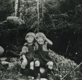
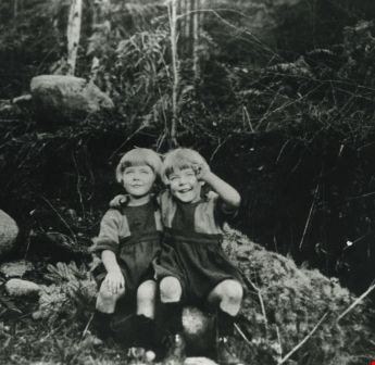
Cutting down a Christmas tree
https://search.heritageburnaby.ca/link/archivedescription35382
- Repository
- City of Burnaby Archives
- Date
- 1925
- Collection/Fonds
- Burnaby Historical Society fonds
- Description Level
- Item
- Physical Description
- 1 photograph : b&w ; 12.7 x 17.8 cm print
- Scope and Content
- Photograph of twin sisters, Kay and Evelyn Rorison, cutting down a Christmas tree. Kay and Evelyn were the daughters of William and Alma Rorison of 3907 River Road (later becoming 4593 Marine Drive at Strathern Avenue).
- Repository
- City of Burnaby Archives
- Date
- 1925
- Collection/Fonds
- Burnaby Historical Society fonds
- Subseries
- Pioneer Tales subseries
- Physical Description
- 1 photograph : b&w ; 12.7 x 17.8 cm print
- Description Level
- Item
- Record No.
- 204-239
- Access Restriction
- No restrictions
- Reproduction Restriction
- No known restrictions
- Accession Number
- BHS1988-03
- Scope and Content
- Photograph of twin sisters, Kay and Evelyn Rorison, cutting down a Christmas tree. Kay and Evelyn were the daughters of William and Alma Rorison of 3907 River Road (later becoming 4593 Marine Drive at Strathern Avenue).
- Subjects
- Plants - Trees
- Media Type
- Photograph
- Notes
- Title based on contents of photograph
- Geographic Access
- Marine Drive
- Street Address
- 4593 Marine Drive
- Historic Neighbourhood
- Fraser Arm (Historic Neighbourhood)
- Planning Study Area
- Sussex-Nelson Area
Images
![Eagle Creek treehouse, [between 1980 and 2001] thumbnail](/media/hpo/_Data/_Archives_Images/_Unrestricted/600/618-022-1.jpg?width=280)
Eagle Creek treehouse
https://search.heritageburnaby.ca/link/archivedescription91704
- Repository
- City of Burnaby Archives
- Date
- [between 1980 and 2001]
- Collection/Fonds
- Doreen Lawson fonds
- Description Level
- File
- Physical Description
- 5 photographs : col. ; 15 cm x 10 cm
- Scope and Content
- File consists of photographs of a rustic two-storey treehouse located in the forest at Eagle Creek. The treehouse is triangular in shape and constructed around three evergreen trees. The file also contains one photograph of a broken tree stump.
- Repository
- City of Burnaby Archives
- Date
- [between 1980 and 2001]
- Collection/Fonds
- Doreen Lawson fonds
- Physical Description
- 5 photographs : col. ; 15 cm x 10 cm
- Description Level
- File
- Record No.
- 618-022
- Access Restriction
- No restrictions
- Reproduction Restriction
- No restrictions
- Accession Number
- 2015-15
- Scope and Content
- File consists of photographs of a rustic two-storey treehouse located in the forest at Eagle Creek. The treehouse is triangular in shape and constructed around three evergreen trees. The file also contains one photograph of a broken tree stump.
- Subjects
- Plants - Trees
- Media Type
- Photograph
- Photographer
- Lawson, Doreen A.
- Notes
- Title based on contents of photographs
- Note in black in on verso of photographs 618-022-1 : 618-022-4 reads: "Bby. Mtn. Parkway [at] Curtis / Eagle Creek, Upper Reaches / East Fork"
- Note in black in on verso of photograph 618-022-5 reads: "Bby. Mtn. Parkway / Eagle Creek, Upper Reaches"
- Geographic Access
- Eagle Creek
- Planning Study Area
- Sperling-Broadway Area
Images
![Eagle Creek treehouse, [between 1980 and 2001] thumbnail](/media/hpo/_Data/_Archives_Images/_Unrestricted/600/618-022-1.jpg)

Ernie Carpenter clearing land
https://search.heritageburnaby.ca/link/archivedescription35789
- Repository
- City of Burnaby Archives
- Date
- 1923 (date of original), copied 1986
- Collection/Fonds
- Burnaby Historical Society fonds
- Description Level
- Item
- Physical Description
- 1 photograph : b&w ; 12.7 x 17.8 cm print
- Scope and Content
- Photograph of Ernie Carpenter clearing a lot at 3336 Beresford Street (later renumbered 5268 Beresford Street) near Royal Oak Avenue. Mr. Carpenter built a house here, and then cultivated an English garden and prize-winning onions and flowers.
- Repository
- City of Burnaby Archives
- Date
- 1923 (date of original), copied 1986
- Collection/Fonds
- Burnaby Historical Society fonds
- Subseries
- Pioneer Tales subseries
- Physical Description
- 1 photograph : b&w ; 12.7 x 17.8 cm print
- Description Level
- Item
- Record No.
- 204-647
- Access Restriction
- No restrictions
- Reproduction Restriction
- No known restrictions
- Accession Number
- BHS1988-03
- Scope and Content
- Photograph of Ernie Carpenter clearing a lot at 3336 Beresford Street (later renumbered 5268 Beresford Street) near Royal Oak Avenue. Mr. Carpenter built a house here, and then cultivated an English garden and prize-winning onions and flowers.
- Subjects
- Land Clearing
- Plants - Trees
- Names
- Carpenter, Ernie
- Media Type
- Photograph
- Notes
- Title based on contents of photograph
- Geographic Access
- Beresford Street
- Street Address
- 5268 Beresford Street
- Historic Neighbourhood
- Central Park (Historic Neighbourhood)
- Planning Study Area
- Windsor Area
Images


Fir stump
https://search.heritageburnaby.ca/link/archivedescription34165
- Repository
- City of Burnaby Archives
- Date
- May 1, 1947
- Collection/Fonds
- Burnaby Historical Society fonds
- Description Level
- Item
- Physical Description
- 1 photograph : b&w negative ; 6.8 x 11.4 cm
- Scope and Content
- Photograph of fir tree stump taken after blasting on the 4200 block of Grant Street. This is part of the Willingdon Heights subdivision site.
- Repository
- City of Burnaby Archives
- Date
- May 1, 1947
- Collection/Fonds
- Burnaby Historical Society fonds
- Subseries
- Alfred Bingham subseries
- Physical Description
- 1 photograph : b&w negative ; 6.8 x 11.4 cm
- Description Level
- Item
- Record No.
- 010-082
- Access Restriction
- No restrictions
- Reproduction Restriction
- No known restrictions
- Accession Number
- BHS2007-04
- Scope and Content
- Photograph of fir tree stump taken after blasting on the 4200 block of Grant Street. This is part of the Willingdon Heights subdivision site.
- Subjects
- Land Clearing
- Plants - Trees
- Media Type
- Photograph
- Photographer
- Bingham, Alfred "Alf"
- Notes
- Title based on contents of photograph
- Geographic Access
- Grant Street
Images

![From Antrim Avenue, [1943] (date of original), copied 1991 thumbnail](/media/hpo/_Data/_Archives_Images/_Unrestricted/370/370-656.jpg?width=280)
From Antrim Avenue
https://search.heritageburnaby.ca/link/archivedescription38069
- Repository
- City of Burnaby Archives
- Date
- [1943] (date of original), copied 1991
- Collection/Fonds
- Burnaby Historical Society fonds
- Description Level
- Item
- Physical Description
- 1 photograph : b&w ; 2.9 x 4.3 cm print on contact sheet 20.4 x 26.5 cm
- Scope and Content
- Photograph taken looking south from the back of 2224 Antrim Avenue (later renumbered 6957 Antrim Avenue). The British Columbia Electric Railway Company tracks and Central Park tram are partially visible in the background.
- Repository
- City of Burnaby Archives
- Date
- [1943] (date of original), copied 1991
- Collection/Fonds
- Burnaby Historical Society fonds
- Subseries
- Burnaby Image Bank subseries
- Physical Description
- 1 photograph : b&w ; 2.9 x 4.3 cm print on contact sheet 20.4 x 26.5 cm
- Description Level
- Item
- Record No.
- 370-656
- Access Restriction
- No restrictions
- Reproduction Restriction
- No known restrictions
- Accession Number
- BHS1999-03
- Scope and Content
- Photograph taken looking south from the back of 2224 Antrim Avenue (later renumbered 6957 Antrim Avenue). The British Columbia Electric Railway Company tracks and Central Park tram are partially visible in the background.
- Subjects
- Plants - Trees
- Media Type
- Photograph
- Notes
- Title based on contents of photograph
- 1 b&w copy negative accompanying
- Negative has a pink cast
- Geographic Access
- Antrim Avenue
- Street Address
- 6957 Antrim Avenue
- Historic Neighbourhood
- Central Park (Historic Neighbourhood)
- Planning Study Area
- Windsor Area
Images
![From Antrim Avenue, [1943] (date of original), copied 1991 thumbnail](/media/hpo/_Data/_Archives_Images/_Unrestricted/370/370-656.jpg)
Grant family getting Christmas trees
https://search.heritageburnaby.ca/link/archivedescription36868
- Repository
- City of Burnaby Archives
- Date
- 1920 (date of original), copied 1992
- Collection/Fonds
- Burnaby Historical Society fonds
- Description Level
- Item
- Physical Description
- 1 photograph : b&w ; 8.7 x 12.6 cm print
- Scope and Content
- Photograph of George A. Grant and three children getting three Christmas trees from the bush between Marlborough Avenue and Royal Oak Road. The smallest child is sitting on a sled. There were five Grant children: William "Bill," George, Heriot "Harry," Millie, and Alastair.
- Repository
- City of Burnaby Archives
- Date
- 1920 (date of original), copied 1992
- Collection/Fonds
- Burnaby Historical Society fonds
- Subseries
- Burnaby Centennial Anthology subseries
- Physical Description
- 1 photograph : b&w ; 8.7 x 12.6 cm print
- Description Level
- Item
- Record No.
- 315-326
- Access Restriction
- No restrictions
- Reproduction Restriction
- No known restrictions
- Accession Number
- BHS1994-04
- Scope and Content
- Photograph of George A. Grant and three children getting three Christmas trees from the bush between Marlborough Avenue and Royal Oak Road. The smallest child is sitting on a sled. There were five Grant children: William "Bill," George, Heriot "Harry," Millie, and Alastair.
- Media Type
- Photograph
- Notes
- Title based on contents of photograph
- Geographic Access
- Marlborough Avenue
- Royal Oak Avenue
- Historic Neighbourhood
- Central Park (Historic Neighbourhood)
- Planning Study Area
- Marlborough Area
Images

Grant Street
https://search.heritageburnaby.ca/link/archivedescription34157
- Repository
- City of Burnaby Archives
- Date
- April 25, 1947
- Collection/Fonds
- Burnaby Historical Society fonds
- Description Level
- Item
- Physical Description
- 1 photograph : b&w negative ; 6.8 x 10.9 cm
- Scope and Content
- Photograph of a fir stump with 670 rings on the 4200 block of Grant Street. An unidentified man is standing to the left of it with a shovel. This is part of the Willingdon Heights subdivision site.
- Repository
- City of Burnaby Archives
- Date
- April 25, 1947
- Collection/Fonds
- Burnaby Historical Society fonds
- Subseries
- Alfred Bingham subseries
- Physical Description
- 1 photograph : b&w negative ; 6.8 x 10.9 cm
- Description Level
- Item
- Record No.
- 010-074
- Access Restriction
- No restrictions
- Reproduction Restriction
- Reproduce for fair dealing purposes only
- Accession Number
- BHS2007-04
- Scope and Content
- Photograph of a fir stump with 670 rings on the 4200 block of Grant Street. An unidentified man is standing to the left of it with a shovel. This is part of the Willingdon Heights subdivision site.
- Subjects
- Land Clearing
- Plants - Trees
- Media Type
- Photograph
- Photographer
- Bingham, Alfred "Alf"
- Notes
- Title based on contents of photograph
- Geographic Access
- Grant Street
Images
