More like 'Interview with Barry Jones by Kathy Bossort December 9, 2015 - Track 2'
Narrow Results By
Subject
- Advertising Medium - Signs and Signboards 3
- Aerial Photographs 1
- Agricultural Tools and Equipment - Gardening Equipment 1
- Agricultural Tools and Equipment - Plows 1
- Agriculture 1
- Agriculture - Farms 3
- Agriculture - Fruit and Berries 2
- Animals - Birds 2
- Animals - Cats 2
- Animals - Cows 1
- Animals - Deer 1
- Animals - Dogs 16

Boston Bar Creek on the Kettle Valley Railroad
https://search.heritageburnaby.ca/link/archivedescription34451
- Repository
- City of Burnaby Archives
- Date
- 1925
- Collection/Fonds
- Burnaby Historical Society fonds
- Description Level
- Item
- Physical Description
- 1 photograph : b&w ; 7 x 12.2 cm on page 17.5 x 26.5 cm
- Scope and Content
- Photograph of a railway bed running alongside a creek at the foot of a forested mountain. Power lines can be seen running in the foreground. The caption to the photograph reads: "Boston Bar Creek on the KVR."
- Repository
- City of Burnaby Archives
- Date
- 1925
- Collection/Fonds
- Burnaby Historical Society fonds
- Subseries
- Peers family subseries
- Physical Description
- 1 photograph : b&w ; 7 x 12.2 cm on page 17.5 x 26.5 cm
- Description Level
- Item
- Record No.
- 020-158
- Access Restriction
- No restrictions
- Reproduction Restriction
- No known restrictions
- Accession Number
- BHS2007-04
- Scope and Content
- Photograph of a railway bed running alongside a creek at the foot of a forested mountain. Power lines can be seen running in the foreground. The caption to the photograph reads: "Boston Bar Creek on the KVR."
- Media Type
- Photograph
- Notes
- Title based on caption accompanying photograph
Images

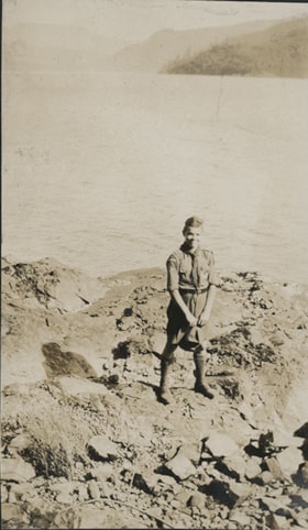
Boy Scout on rocky shore
https://search.heritageburnaby.ca/link/museumdescription20721
- Repository
- Burnaby Village Museum
- Date
- Aug. 1926
- Collection/Fonds
- David Geoffrey Llewellyn collection
- Description Level
- Item
- Physical Description
- 1 photograph : b&w ; 10.5 x 6.5 cm
- Scope and Content
- Photograph of Boy Scout standing on rocky shore at Granthams Landing. View from shore looking towards Keats and Bowen Island. Boy Scout is attending New Westminster District Boy Scout camp at Granthams Landing.
- Repository
- Burnaby Village Museum
- Collection/Fonds
- David Geoffrey Llewellyn collection
- Description Level
- Item
- Physical Description
- 1 photograph : b&w ; 10.5 x 6.5 cm
- Scope and Content
- Photograph of Boy Scout standing on rocky shore at Granthams Landing. View from shore looking towards Keats and Bowen Island. Boy Scout is attending New Westminster District Boy Scout camp at Granthams Landing.
- Subjects
- Organizations - Boys' Societies and Clubs
- Geographic Features - Islands
- Geographic Features - Natural Waterways
- Names
- Boy Scouts of Canada
- Accession Code
- BV995.8.152
- Access Restriction
- No restrictions
- Reproduction Restriction
- No known restrictions
- Date
- Aug. 1926
- Media Type
- Photograph
- Scan Resolution
- 600
- Notes
- Title based on contents of photograph
- Photograph is part of photograph album BV995.8.1, pasted to page 43
Images


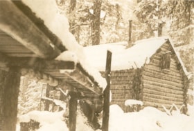
Bridge over the creek in front of "Argu-In" cabin on Mount Seymour
https://search.heritageburnaby.ca/link/museumdescription2921
- Repository
- Burnaby Village Museum
- Date
- [between 1939 and 1949] (date of orignals), copied 2008
- Collection/Fonds
- Pixie McGeachie fonds
- Description Level
- Item
- Physical Description
- 1 photograph (tiff) : b&w ; 600 dpi
- Scope and Content
- Photograph of a snow covered bridge leading to Jack and Pixie McGeachie's log cabin on Mount Seymour, North Vancouver. Jack McGeachie and friends, Maurice Skinner and Jack Gannon built and maintained a cabin with friends on Mount Seymour from 1938 until after the Second World War.
- Repository
- Burnaby Village Museum
- Collection/Fonds
- Pixie McGeachie fonds
- Description Level
- Item
- Physical Description
- 1 photograph (tiff) : b&w ; 600 dpi
- Scope and Content
- Photograph of a snow covered bridge leading to Jack and Pixie McGeachie's log cabin on Mount Seymour, North Vancouver. Jack McGeachie and friends, Maurice Skinner and Jack Gannon built and maintained a cabin with friends on Mount Seymour from 1938 until after the Second World War.
- Subjects
- Natural Phenomena - Snow
- Geographic Features - Forests
- Geographic Features - Mountains - British Columbia
- Buildings - Residential - Cabins
- Accession Code
- BV008.17.10
- Access Restriction
- No restrictions
- Reproduction Restriction
- May be restricted by third party rights
- Date
- [between 1939 and 1949] (date of orignals), copied 2008
- Media Type
- Photograph
- Notes
- Title based on contents of photograph
Images

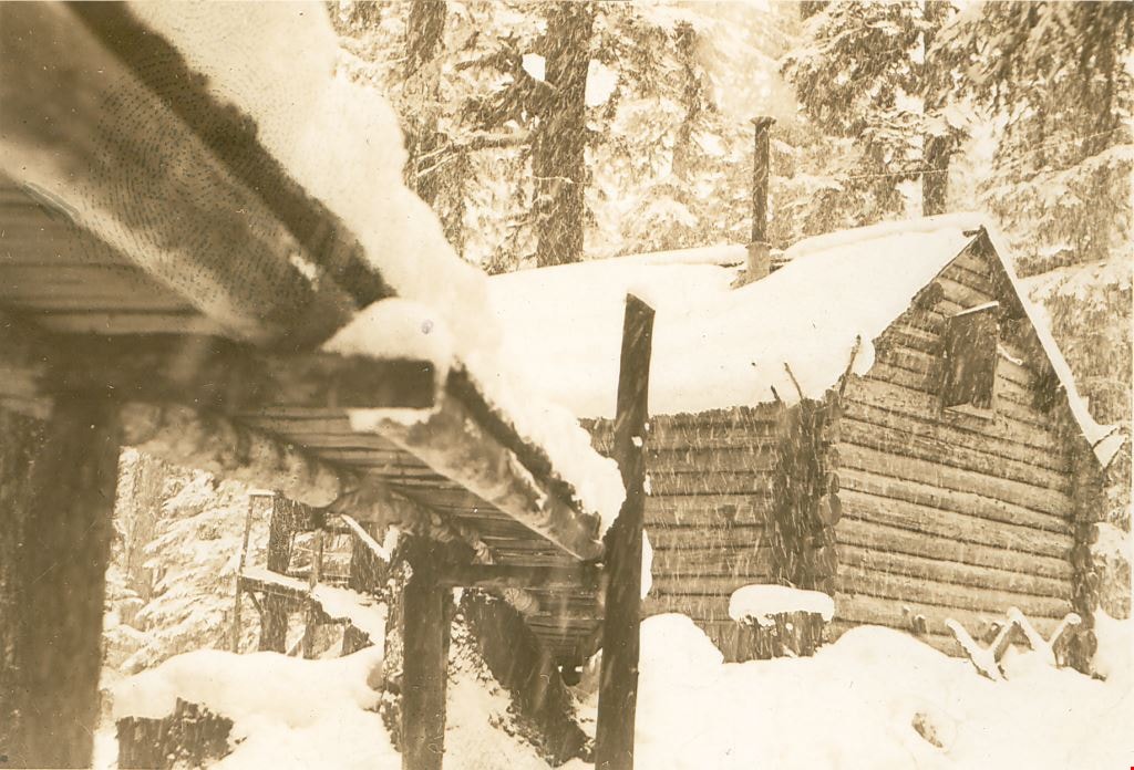
Bridge to "Argu-In" on Mount Seymour
https://search.heritageburnaby.ca/link/museumdescription2926
- Repository
- Burnaby Village Museum
- Date
- [between 1939 and 1949] (date of orignals), copied 2008
- Collection/Fonds
- Pixie McGeachie fonds
- Description Level
- Item
- Physical Description
- 1 photograph (tiff) : b&w ; 600 dpi
- Scope and Content
- Photograph of Jack and Pixie McGeachie's snow covered log cabin, "Argu-In" with a snow covered wooden bridge leading up to it. The photograph is taken from under the bridge which leads to the cabin on Mount Seymour, North Vancouver. Jack McGeachie and friends, Maurice Skinner and Jack Gannon built…
- Repository
- Burnaby Village Museum
- Collection/Fonds
- Pixie McGeachie fonds
- Description Level
- Item
- Physical Description
- 1 photograph (tiff) : b&w ; 600 dpi
- Scope and Content
- Photograph of Jack and Pixie McGeachie's snow covered log cabin, "Argu-In" with a snow covered wooden bridge leading up to it. The photograph is taken from under the bridge which leads to the cabin on Mount Seymour, North Vancouver. Jack McGeachie and friends, Maurice Skinner and Jack Gannon built and maintained a cabin with friends on Mount Seymour from 1938 until after the Second World War.
- Subjects
- Natural Phenomena - Snow
- Geographic Features - Forests
- Geographic Features - Mountains - British Columbia
- Buildings - Residential - Cabins
- Accession Code
- BV008.17.15
- Access Restriction
- No restrictions
- Reproduction Restriction
- May be restricted by third party rights
- Date
- [between 1939 and 1949] (date of orignals), copied 2008
- Media Type
- Photograph
- Notes
- Title based on contents of photograph
Images

Burnaby Lake
https://search.heritageburnaby.ca/link/archivedescription34563
- Repository
- City of Burnaby Archives
- Date
- 1923
- Collection/Fonds
- Burnaby Historical Society fonds
- Description Level
- Item
- Physical Description
- 1 photograph : b&w ; 17.4 x 35.3 cm
- Scope and Content
- Photograph of Burnaby Lake, looking northwest. The north shore mountains, including The Lions, can be seen in the background.
- Repository
- City of Burnaby Archives
- Date
- 1923
- Collection/Fonds
- Burnaby Historical Society fonds
- Subseries
- Photographs subseries
- Physical Description
- 1 photograph : b&w ; 17.4 x 35.3 cm
- Description Level
- Item
- Record No.
- 050-001
- Access Restriction
- No restrictions
- Reproduction Restriction
- No known restrictions
- Accession Number
- BHS2007-04
- Scope and Content
- Photograph of Burnaby Lake, looking northwest. The north shore mountains, including The Lions, can be seen in the background.
- Media Type
- Photograph
- Notes
- Title based on contents of photograph
- Geographic Access
- Burnaby Lake
- Historic Neighbourhood
- Burnaby Lake (Historic Neighbourhood)
- Planning Study Area
- Burnaby Lake Area
Images

![Burrard Inlet, [1926] (date of original), copied 1986 thumbnail](/media/hpo/_Data/_Archives_Images/_Unrestricted/204/204-455.jpg?width=280)
Burrard Inlet
https://search.heritageburnaby.ca/link/archivedescription35597
- Repository
- City of Burnaby Archives
- Date
- [1926] (date of original), copied 1986
- Collection/Fonds
- Burnaby Historical Society fonds
- Description Level
- Item
- Physical Description
- 1 photograph : b&w ; 12.7 x 17.8 cm print
- Scope and Content
- Photograph looking across Burrard Inlet from the Donovan family home, 4112 Yale Street, before the Second Narrows Bridge was built at this spot.
- Repository
- City of Burnaby Archives
- Date
- [1926] (date of original), copied 1986
- Collection/Fonds
- Burnaby Historical Society fonds
- Subseries
- Pioneer Tales subseries
- Physical Description
- 1 photograph : b&w ; 12.7 x 17.8 cm print
- Description Level
- Item
- Record No.
- 204-455
- Access Restriction
- No restrictions
- Reproduction Restriction
- No known restrictions
- Accession Number
- BHS1988-03
- Scope and Content
- Photograph looking across Burrard Inlet from the Donovan family home, 4112 Yale Street, before the Second Narrows Bridge was built at this spot.
- Media Type
- Photograph
- Notes
- Title based on contents of photograph
- Geographic Access
- Burrard Inlet
- Historic Neighbourhood
- Vancouver Heights (Historic Neighbourhood)
- Planning Study Area
- Burnaby Heights Area
Images
![Burrard Inlet, [1926] (date of original), copied 1986 thumbnail](/media/hpo/_Data/_Archives_Images/_Unrestricted/204/204-455.jpg)

Burrard Inlet
https://search.heritageburnaby.ca/link/archivedescription35598
- Repository
- City of Burnaby Archives
- Date
- 1928 (date of original), copied 1986
- Collection/Fonds
- Burnaby Historical Society fonds
- Description Level
- Item
- Physical Description
- 1 photograph : b&w ; 12.7 x 17.8 cm print
- Scope and Content
- Photograph of Burrard Inlet looking north from the 3800 block of Yale Street, the closest street to the water at that time. Power lines were being strung across the inlet that year.
- Repository
- City of Burnaby Archives
- Date
- 1928 (date of original), copied 1986
- Collection/Fonds
- Burnaby Historical Society fonds
- Subseries
- Pioneer Tales subseries
- Physical Description
- 1 photograph : b&w ; 12.7 x 17.8 cm print
- Description Level
- Item
- Record No.
- 204-456
- Access Restriction
- No restrictions
- Reproduction Restriction
- No known restrictions
- Accession Number
- BHS1988-03
- Scope and Content
- Photograph of Burrard Inlet looking north from the 3800 block of Yale Street, the closest street to the water at that time. Power lines were being strung across the inlet that year.
- Media Type
- Photograph
- Notes
- Title based on contents of photograph
- Geographic Access
- Burrard Inlet
- Historic Neighbourhood
- Vancouver Heights (Historic Neighbourhood)
- Planning Study Area
- Burnaby Heights Area
Images

![Burrard Inlet, [1930] thumbnail](/media/hpo/_Data/_Archives_Images/_Unrestricted/371/443-004.jpg?width=280)
Burrard Inlet
https://search.heritageburnaby.ca/link/archivedescription38437
- Repository
- City of Burnaby Archives
- Date
- [1930]
- Collection/Fonds
- Burnaby Historical Society fonds
- Description Level
- Item
- Physical Description
- 1 photograph : b&w ; 6.3 x 9 cm
- Scope and Content
- Photograph of Burrard Inlet from Capitol Hill, taken from 410 North Hythe Avenue.
- Repository
- City of Burnaby Archives
- Date
- [1930]
- Collection/Fonds
- Burnaby Historical Society fonds
- Subseries
- Photographs subseries
- Physical Description
- 1 photograph : b&w ; 6.3 x 9 cm
- Description Level
- Item
- Record No.
- 443-004
- Access Restriction
- No restrictions
- Reproduction Restriction
- No known restrictions
- Accession Number
- BHS2002-13
- Scope and Content
- Photograph of Burrard Inlet from Capitol Hill, taken from 410 North Hythe Avenue.
- Media Type
- Photograph
- Notes
- Title based on contents of photograph
- Geographic Access
- Hythe Avenue North
- Street Address
- 410 Hythe Avenue North
- Historic Neighbourhood
- Capitol Hill (Historic Neighbourhood)
- Planning Study Area
- Capitol Hill Area
Images
![Burrard Inlet, [1930] thumbnail](/media/hpo/_Data/_Archives_Images/_Unrestricted/371/443-004.jpg)
![Burrard Inlet, [1930] thumbnail](/media/hpo/_Data/_Archives_Images/_Unrestricted/371/443-011.jpg?width=280)
Burrard Inlet
https://search.heritageburnaby.ca/link/archivedescription38444
- Repository
- City of Burnaby Archives
- Date
- [1930]
- Collection/Fonds
- Burnaby Historical Society fonds
- Description Level
- Item
- Physical Description
- 1 photograph : b&w ; 10 x 24 cm
- Scope and Content
- Photograph of the Burrard Inlet, taken from 410 North Hythe Avenue North Burnaby.
- Repository
- City of Burnaby Archives
- Date
- [1930]
- Collection/Fonds
- Burnaby Historical Society fonds
- Subseries
- Photographs subseries
- Physical Description
- 1 photograph : b&w ; 10 x 24 cm
- Description Level
- Item
- Record No.
- 443-011
- Access Restriction
- No restrictions
- Reproduction Restriction
- No known restrictions
- Accession Number
- BHS2002-13
- Scope and Content
- Photograph of the Burrard Inlet, taken from 410 North Hythe Avenue North Burnaby.
- Media Type
- Photograph
- Notes
- Title based on contents of photograph
- Geographic Access
- Hythe Avenue North
- Street Address
- 410 Hythe Avenue North
- Historic Neighbourhood
- Capitol Hill (Historic Neighbourhood)
- Planning Study Area
- Capitol Hill Area
Images
![Burrard Inlet, [1930] thumbnail](/media/hpo/_Data/_Archives_Images/_Unrestricted/371/443-011.jpg)
![Burrard Inlet in winter, [192-] thumbnail](/media/hpo/_Data/_BVM_Images/2007/2007_0045_0017_001.jpg?width=280)
Burrard Inlet in winter
https://search.heritageburnaby.ca/link/museumdescription3902
- Repository
- Burnaby Village Museum
- Date
- [192-]
- Collection/Fonds
- Burnaby Village Museum Photograph collection
- Description Level
- Item
- Physical Description
- 1 photograph : b&w ; 26.5 x 16 cm
- Scope and Content
- Photograph of a Vancouver Heights streetscape in winter. There is snow on the ground. One of the houses across the street has what appears to be a radio mast in the front yard. The photograph is taken looking Northeast toward the Burrard Inlet with Mount Seymour in the background.
- Repository
- Burnaby Village Museum
- Collection/Fonds
- Burnaby Village Museum Photograph collection
- Description Level
- Item
- Physical Description
- 1 photograph : b&w ; 26.5 x 16 cm
- Material Details
- "Burrard Inlet - winter" written in ink on back of photo. "37" written in pencil on back of photo.
- Scope and Content
- Photograph of a Vancouver Heights streetscape in winter. There is snow on the ground. One of the houses across the street has what appears to be a radio mast in the front yard. The photograph is taken looking Northeast toward the Burrard Inlet with Mount Seymour in the background.
- History
- George Vincent Martin was born in 1892 in England. He married Matilda Florence Reed in 1916. He purchased a property in North Burnaby in the 1920s on Trinity Street. There was a main house and a "shack" on the property split up onto two lots.
- Subjects
- Natural Phenomena - Snow
- Geographic Features - Mountains
- Geographic Features - Inlets
- Buildings - Residential - Houses
- Accession Code
- BV007.45.17
- Access Restriction
- No restrictions
- Reproduction Restriction
- No known restrictions
- Date
- [192-]
- Media Type
- Photograph
- Scan Resolution
- 300
- Scan Date
- 29-Nov-2018
- Scale
- 96
- Notes
- Title based on content of the photograph
Images
![Burrard Inlet in winter, [192-] thumbnail](/media/hpo/_Data/_BVM_Images/2007/2007_0045_0017_001.jpg)
![Burrard Inlet looking towards Grouse Mountain, [1930] thumbnail](/media/hpo/_Data/_Archives_Images/_Unrestricted/371/443-002.jpg?width=280)
Burrard Inlet looking towards Grouse Mountain
https://search.heritageburnaby.ca/link/archivedescription38435
- Repository
- City of Burnaby Archives
- Date
- [1930]
- Collection/Fonds
- Burnaby Historical Society fonds
- Description Level
- Item
- Physical Description
- 1 photograph : b&w ; 6.3 x 9 cm
- Scope and Content
- Photograph of Grouse Mountain, from across the Burrard Inlet. This photograph was taken from 410 North Hythe Avenue.
- Repository
- City of Burnaby Archives
- Date
- [1930]
- Collection/Fonds
- Burnaby Historical Society fonds
- Subseries
- Photographs subseries
- Physical Description
- 1 photograph : b&w ; 6.3 x 9 cm
- Description Level
- Item
- Record No.
- 443-002
- Access Restriction
- No restrictions
- Reproduction Restriction
- No known restrictions
- Accession Number
- BHS2002-13
- Scope and Content
- Photograph of Grouse Mountain, from across the Burrard Inlet. This photograph was taken from 410 North Hythe Avenue.
- Media Type
- Photograph
- Notes
- Title based on contents of photograph.
- Geographic Access
- Hythe Avenue North
- Historic Neighbourhood
- Capitol Hill (Historic Neighbourhood)
- Planning Study Area
- Capitol Hill Area
Images
![Burrard Inlet looking towards Grouse Mountain, [1930] thumbnail](/media/hpo/_Data/_Archives_Images/_Unrestricted/371/443-002.jpg)

Cable Crossing at Mile 57
https://search.heritageburnaby.ca/link/archivedescription34397
- Repository
- City of Burnaby Archives
- Date
- 1926
- Collection/Fonds
- Burnaby Historical Society fonds
- Description Level
- Item
- Physical Description
- 1 photograph : b&w ; 7.2 x 9.5 cm on page 17.4 x 26.2 cm
- Scope and Content
- Photograph taken looking over a river towards Cheam Peak, which is visible in the background. A cable can be seen stretching over the river. This photograph appears to have been taken by Arthur Peers, who travelled through the Fraser River Valley and worked on the construction of the Trans-Provinc…
- Repository
- City of Burnaby Archives
- Date
- 1926
- Collection/Fonds
- Burnaby Historical Society fonds
- Subseries
- Peers family subseries
- Physical Description
- 1 photograph : b&w ; 7.2 x 9.5 cm on page 17.4 x 26.2 cm
- Description Level
- Item
- Record No.
- 020-104
- Access Restriction
- No restrictions
- Reproduction Restriction
- No known restrictions
- Accession Number
- BHS2007-04
- Scope and Content
- Photograph taken looking over a river towards Cheam Peak, which is visible in the background. A cable can be seen stretching over the river. This photograph appears to have been taken by Arthur Peers, who travelled through the Fraser River Valley and worked on the construction of the Trans-Provincial Highway during the later 1920s.
- Media Type
- Photograph
- Photographer
- Peers, Arthur Francis "Mike"
- Notes
- Title based on caption accompanying photograph
Images


The Castle and Mount Frink
https://search.heritageburnaby.ca/link/archivedescription51446
- Repository
- City of Burnaby Archives
- Date
- 1938
- Collection/Fonds
- Burnaby Historical Society fonds
- Description Level
- Item
- Physical Description
- 1 photograph : b&w postcard ; 8 x 13 cm, mounted on heavy-weight paper 17.5 x 26.5 cm
- Scope and Content
- Photographic postcard of Moat Lake, with the two mountains known as the Castle (Castlecrag Mountain) and Mount Fink in the distance. This was part of a trip to the Forbidden Plateau on Vancouver Island made by a small party of City of Courtenay officials. George A. Grant was one of the climbers in …
- Repository
- City of Burnaby Archives
- Date
- 1938
- Collection/Fonds
- Burnaby Historical Society fonds
- Subseries
- George Grant subseries
- Physical Description
- 1 photograph : b&w postcard ; 8 x 13 cm, mounted on heavy-weight paper 17.5 x 26.5 cm
- Description Level
- Item
- Record No.
- 243-051
- Access Restriction
- No restrictions
- Reproduction Restriction
- No known restrictions
- Accession Number
- BHS1990-06
- Scope and Content
- Photographic postcard of Moat Lake, with the two mountains known as the Castle (Castlecrag Mountain) and Mount Fink in the distance. This was part of a trip to the Forbidden Plateau on Vancouver Island made by a small party of City of Courtenay officials. George A. Grant was one of the climbers in the party.
- Media Type
- Photograph
- Photographer
- Tait, Preston L.
- Notes
- Title taken from handwritten title on paper mount
- Handwritten note on facing page reads: "Where rose the mountains / There to him were friends / Byron"
- Photographer identifies photograph as no. 805
Images


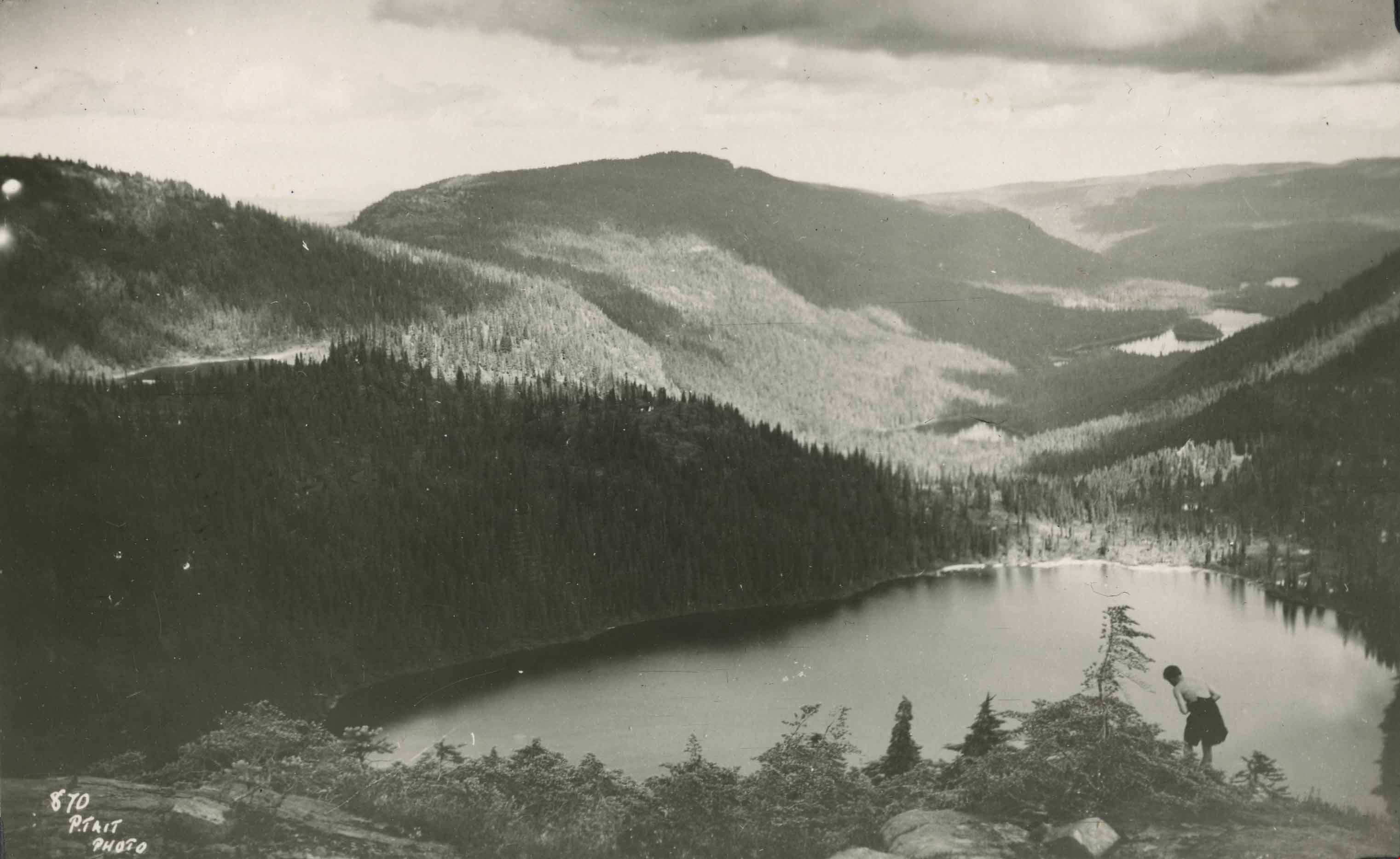
Circle Lake
https://search.heritageburnaby.ca/link/archivedescription51448
- Repository
- City of Burnaby Archives
- Date
- 1938
- Collection/Fonds
- Burnaby Historical Society fonds
- Description Level
- Item
- Physical Description
- 1 photograph : b&w postcard ; 8 x 13 cm, mounted on heavy-weight paper 17.5 x 26.5 cm
- Scope and Content
- Photographic postcard of Circle (Circlet) lake nestled among the mountains of the Forbidden Plateau on Vancouver Island, BC. A young man is making his way down Mount Albert Edward, towards the lake. This was part of a trip to the Forbidden Plateau made by a small party of City of Courtenay official…
- Repository
- City of Burnaby Archives
- Date
- 1938
- Collection/Fonds
- Burnaby Historical Society fonds
- Subseries
- George Grant subseries
- Physical Description
- 1 photograph : b&w postcard ; 8 x 13 cm, mounted on heavy-weight paper 17.5 x 26.5 cm
- Description Level
- Item
- Record No.
- 243-053
- Access Restriction
- No restrictions
- Reproduction Restriction
- No known restrictions
- Accession Number
- BHS1990-06
- Scope and Content
- Photographic postcard of Circle (Circlet) lake nestled among the mountains of the Forbidden Plateau on Vancouver Island, BC. A young man is making his way down Mount Albert Edward, towards the lake. This was part of a trip to the Forbidden Plateau made by a small party of City of Courtenay officials. George A. Grant was one of the climbers in the party.
- Subjects
- Geographic Features - Mountains
- Geographic Features - Lakes and Ponds
- Recreational Activities - Hiking
- Media Type
- Photograph
- Photographer
- Tait, Preston L.
- Notes
- Title taken from handwritten title on paper mount
- Handwritten note on on facing page reads: "Th' outstretching lake, embosomed' mong the hills / The eye with wonder and amazement fills / Burns"
- Photographer identifies photograph as no. 870
Images

Construction of dykes on Nicomen Island
https://search.heritageburnaby.ca/link/archivedescription34330
- Repository
- City of Burnaby Archives
- Date
- 1927
- Collection/Fonds
- Burnaby Historical Society fonds
- Description Level
- Item
- Physical Description
- 1 photograph : sepia ; 5 x 13.5 cm on page 17.5 x 22.7 cm
- Scope and Content
- Photograph of a farm and field along the Fraser River next to dykes that are being built on Nicomen Island.
- Repository
- City of Burnaby Archives
- Date
- 1927
- Collection/Fonds
- Burnaby Historical Society fonds
- Subseries
- Peers family subseries
- Physical Description
- 1 photograph : sepia ; 5 x 13.5 cm on page 17.5 x 22.7 cm
- Description Level
- Item
- Record No.
- 020-037
- Access Restriction
- No restrictions
- Reproduction Restriction
- No known restrictions
- Accession Number
- BHS2007-04
- Scope and Content
- Photograph of a farm and field along the Fraser River next to dykes that are being built on Nicomen Island.
- Media Type
- Photograph
- Notes
- Title based on caption accompanying photograph
Images

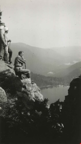
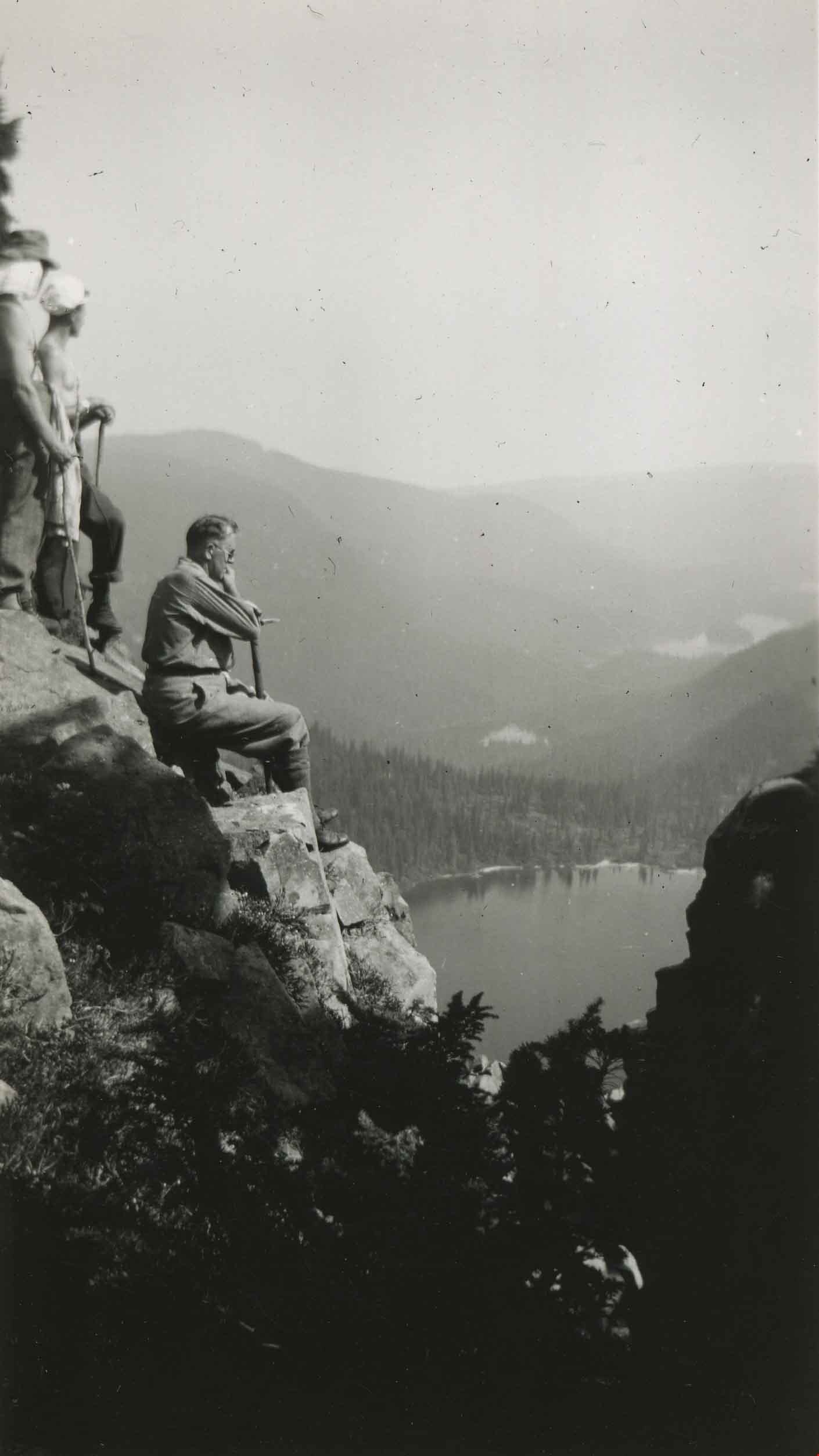
Contemplation
https://search.heritageburnaby.ca/link/archivedescription51449
- Repository
- City of Burnaby Archives
- Date
- August 19, 1938
- Collection/Fonds
- Burnaby Historical Society fonds
- Description Level
- Item
- Physical Description
- 1 photograph : b&w ; 10.5 x 6 cm, mounted on heavy-weight paper 17.5 x 26.5 cm
- Scope and Content
- Photograph of George A. Grant sitting on the rock face of Mount Albert Edward and admiring Circle (Circlet) Lake. Two men are standing just behind him. This was part of a trip to the Forbidden Plateau on Vancouver Island made by a small party of City of Courtenay officials.
- Repository
- City of Burnaby Archives
- Date
- August 19, 1938
- Collection/Fonds
- Burnaby Historical Society fonds
- Subseries
- George Grant subseries
- Physical Description
- 1 photograph : b&w ; 10.5 x 6 cm, mounted on heavy-weight paper 17.5 x 26.5 cm
- Description Level
- Item
- Record No.
- 243-054
- Access Restriction
- No restrictions
- Reproduction Restriction
- No known restrictions
- Accession Number
- BHS1990-06
- Scope and Content
- Photograph of George A. Grant sitting on the rock face of Mount Albert Edward and admiring Circle (Circlet) Lake. Two men are standing just behind him. This was part of a trip to the Forbidden Plateau on Vancouver Island made by a small party of City of Courtenay officials.
- Subjects
- Geographic Features - Mountains
- Geographic Features - Lakes and Ponds
- Recreational Activities - Hiking
- Media Type
- Photograph
- Notes
- Title taken from handwritten title on paper mount
- Handwritten note on facing page reads: "We pause on the Mount Abert [sic] Edward climb to admire Circle Lake and the rest."
- Stamp on verso of print reads: "Vancouver Drug Co. Ltd. AUG 19 1938 Nu-Gloss"
Images

Cottage in the woods
https://search.heritageburnaby.ca/link/archivedescription82641
- Repository
- City of Burnaby Archives
- Date
- 1925
- Collection/Fonds
- Hill family and Vidal family fonds
- Description Level
- Item
- Physical Description
- 1 photograph : b&w ; 9 x 13 cm
- Scope and Content
- Photograph shows cottages, one possibly belonging to Louisa Vidal, near a lake.
- Repository
- City of Burnaby Archives
- Date
- 1925
- Collection/Fonds
- Hill family and Vidal family fonds
- Physical Description
- 1 photograph : b&w ; 9 x 13 cm
- Description Level
- Item
- Record No.
- 550-194
- Access Restriction
- No restrictions
- Reproduction Restriction
- No known restrictions
- Accession Number
- 2013-03
- Scope and Content
- Photograph shows cottages, one possibly belonging to Louisa Vidal, near a lake.
- Subjects
- Buildings - Residential - Cabins
- Geographic Features - Lakes and Ponds
- Geographic Features - Forests
- Media Type
- Photograph
- Notes
- Title based on contents of photograph
- Note in blue pen on verso reads: "1925"
Images

![C.P.R. line, [192-] thumbnail](/media/hpo/_Data/_BVM_Images/2007/2007_0045_0014_001.jpg?width=280)
C.P.R. line
https://search.heritageburnaby.ca/link/museumdescription3898
- Repository
- Burnaby Village Museum
- Date
- [192-]
- Collection/Fonds
- Burnaby Village Museum Photograph collection
- Description Level
- Item
- Physical Description
- 1 photograph : b&w ; 11.5 x 7 cm
- Scope and Content
- Photograph of a trail overlooking Burrard Inlet that runs down a hill through some evergreen trees.
- Repository
- Burnaby Village Museum
- Collection/Fonds
- Burnaby Village Museum Photograph collection
- Description Level
- Item
- Physical Description
- 1 photograph : b&w ; 11.5 x 7 cm
- Material Details
- "You asked me how / far the CPR Line / was from our lot / It is within 1/4 mile / This was taken / right above the / CPR line, there is / quite a sharp descent / from here down to the / line If the piece of / bush to the left was / cut you would see 2nd narrows bridge" written in pencil on the back of the photo.
- Scope and Content
- Photograph of a trail overlooking Burrard Inlet that runs down a hill through some evergreen trees.
- History
- George Vincent Martin was born in 1892 in England. He married Matilda Florence Reed in 1916. He purchased a property in North Burnaby in the 1920s on Trinity Street. There was a main house and a "shack" on the property split up onto two lots.
- Accession Code
- BV007.45.14
- Access Restriction
- No restrictions
- Reproduction Restriction
- No known restrictions
- Date
- [192-]
- Media Type
- Photograph
- Scan Resolution
- 300
- Scan Date
- 29-Nov-2018
- Scale
- 96
- Notes
- Title based on notes on the reverse of the photograph
Images
![C.P.R. line, [192-] thumbnail](/media/hpo/_Data/_BVM_Images/2007/2007_0045_0014_001.jpg)
![Crichton Hawkshaw with Les at Eagle Harbour, [1936] thumbnail](/media/hpo/_Data/_BVM_Images/1996/1996_0006_0125_001.jpg?width=280)
Crichton Hawkshaw with Les at Eagle Harbour
https://search.heritageburnaby.ca/link/museumdescription19441
- Repository
- Burnaby Village Museum
- Date
- [1936]
- Collection/Fonds
- Hawkshaw family fonds
- Description Level
- Item
- Physical Description
- 1 photograph : sepia ; 7 x 11.5 cm
- Scope and Content
- Photograph of Crichton Hawkshaw standing on the shore of Eagle Harbour in West Vancouver with a man named Les. Eagle Harbour rocky shoreline and dock are visible in the background.
- Repository
- Burnaby Village Museum
- Collection/Fonds
- Hawkshaw family fonds
- Description Level
- Item
- Physical Description
- 1 photograph : sepia ; 7 x 11.5 cm
- Scope and Content
- Photograph of Crichton Hawkshaw standing on the shore of Eagle Harbour in West Vancouver with a man named Les. Eagle Harbour rocky shoreline and dock are visible in the background.
- Accession Code
- BV996.6.125
- Access Restriction
- No restrictions
- Reproduction Restriction
- No known restrictions
- Date
- [1936]
- Media Type
- Photograph
- Scan Resolution
- 600
- Scan Date
- 2023-02-06
- Notes
- Title based on contents of photograph
- Caption beneath photograph reads: "ME & LES / EAGLE HARBOUR"
- Photograph is part of photograph album BV996.6.1
Images
![Crichton Hawkshaw with Les at Eagle Harbour, [1936] thumbnail](/media/hpo/_Data/_BVM_Images/1996/1996_0006_0125_001.jpg)
![Cross country skier on Mount Seymour, [between 1939 and 1949] (date of orignals), copied 2008 thumbnail](/media/hpo/_Data/_BVM_Images/2008/2008_0017_0022_001.jpg?width=280)
Cross country skier on Mount Seymour
https://search.heritageburnaby.ca/link/museumdescription2933
- Repository
- Burnaby Village Museum
- Date
- [between 1939 and 1949] (date of orignals), copied 2008
- Collection/Fonds
- Pixie McGeachie fonds
- Description Level
- Item
- Physical Description
- 1 photograph (tiff) : b&w ; 600 dpi
- Scope and Content
- Photograph of a snow covered ski trail and an unidentified cross-country skier on Mount Seymour, North Vancouver.
- Repository
- Burnaby Village Museum
- Collection/Fonds
- Pixie McGeachie fonds
- Description Level
- Item
- Physical Description
- 1 photograph (tiff) : b&w ; 600 dpi
- Scope and Content
- Photograph of a snow covered ski trail and an unidentified cross-country skier on Mount Seymour, North Vancouver.
- Subjects
- Natural Phenomena - Snow
- Geographic Features - Forests
- Geographic Features - Mountains - British Columbia
- Sports - Skiing
- Accession Code
- BV008.17.22
- Access Restriction
- No restrictions
- Reproduction Restriction
- May be restricted by third party rights
- Date
- [between 1939 and 1949] (date of orignals), copied 2008
- Media Type
- Photograph
- Notes
- Title based on contents of photograph
Images
![Cross country skier on Mount Seymour, [between 1939 and 1949] (date of orignals), copied 2008 thumbnail](/media/hpo/_Data/_BVM_Images/2008/2008_0017_0022_001.jpg)