Narrow Results By
Subject
- Aerial Photographs 1
- Agriculture - Farms 1
- Animals - Dogs 2
- Buildings - Recreational - Community Halls 3
- Buildings - Residential - Houses 4
- Buildings - Schools 2
- Ceremonies - Weddings 1
- Clothing - Uniforms 1
- Construction 3
- Geographic Features - Creeks 1
- Geographic Features - Lakes and Ponds 2
- Geographic Features - Roads 1

Government Road Neighbourhood
https://search.heritageburnaby.ca/link/landmark822
- Repository
- Burnaby Heritage Planning
- Associated Dates
- 1955-2008
- Heritage Value
- After the building boom of the 1950s, the Government Road Neighbourhood became characterised as a stable, single-family residential area. In addition to the residential component, the neighbourhood also has a significant industrial sector, along the north side of Burnaby Lake, and a commercial zone to the north along the Lougheed Highway.
- Historic Neighbourhood
- Lozells (Historic Neighbourhood)
- Planning Study Area
- Government Road Area
Images


Lozells Neighbourhood
https://search.heritageburnaby.ca/link/landmark701
- Repository
- Burnaby Heritage Planning
- Associated Dates
- 1925-1954
- Heritage Value
- Like a lot of residential neighbourhoods in Burnaby during the post-War boom, the Lozells area during the 1925-1954 period was one of new construction and subdivisions. Although more homes were being built, the neighbourhood still retained a somewhat rural characteristic well into the 1950s.
- Historic Neighbourhood
- Lozells (Historic Neighbourhood)
- Planning Study Area
- Government Road Area
Images


Lozells Neighbourhood
https://search.heritageburnaby.ca/link/landmark756
- Repository
- Burnaby Heritage Planning
- Associated Dates
- 1905-1924
- Heritage Value
- In 1906 C.T. Piper and Alfred Wiggs built a sawmill at the foot of what is now Piper Avenue along the north shore of Burnaby Lake. These operations and the proximity of the Great Northern Railway encourage settlers to move into this area and among them were Colonel and Mrs. James Ward. They were authorized to open a post office here and Mrs. Ward named it 'Lozells' after the Anglican parish to which she had been a member in Birmingham, England.
- Historic Neighbourhood
- Lozells (Historic Neighbourhood)
- Planning Study Area
- Government Road Area
Images


Begining construction on the Lozells Community Hall
https://search.heritageburnaby.ca/link/archivedescription36420
- Repository
- City of Burnaby Archives
- Date
- 1922
- Collection/Fonds
- Burnaby Historical Society fonds
- Description Level
- Item
- Physical Description
- 1 photograph : col. ; 7 x 11 cm print
- Scope and Content
- Photograph of the begining of construction on the Lozells Community Hall.
- Repository
- City of Burnaby Archives
- Date
- 1922
- Collection/Fonds
- Burnaby Historical Society fonds
- Subseries
- Photographs subseries
- Physical Description
- 1 photograph : col. ; 7 x 11 cm print
- Description Level
- Item
- Record No.
- 267-001
- Access Restriction
- No restrictions
- Reproduction Restriction
- No known restrictions
- Accession Number
- BHS1991-34
- Scope and Content
- Photograph of the begining of construction on the Lozells Community Hall.
- Media Type
- Photograph
- Notes
- Title based on contents of photograph
- Print is a colour copy of a sepia original
- Geographic Access
- Lozells Avenue
- Government Road
- Historic Neighbourhood
- Lozells (Historic Neighbourhood)
- Planning Study Area
- Government Road Area
Images

![Boys in front of Northeast Farmers' Institute, [1926] (date of original), copied 1986 thumbnail](/media/hpo/_Data/_Archives_Images/_Unrestricted/204/204-428.jpg?width=280)
Boys in front of Northeast Farmers' Institute
https://search.heritageburnaby.ca/link/archivedescription35570
- Repository
- City of Burnaby Archives
- Date
- [1926] (date of original), copied 1986
- Collection/Fonds
- Burnaby Historical Society fonds
- Description Level
- Item
- Physical Description
- 1 photograph : b&w ; 12.7 x 17.8 cm print
- Scope and Content
- Photograph of boys in drill team sashes, probably rehearsing for May Day. Identified: (front row, 2nd from left) Gordon Haddon. This photograph was taken in front of the Northeast Farmers' Institute (later called Lozells Community Hall) at 3325 Lozells Avenue in Charles Rummel Park.
- Repository
- City of Burnaby Archives
- Date
- [1926] (date of original), copied 1986
- Collection/Fonds
- Burnaby Historical Society fonds
- Subseries
- Pioneer Tales subseries
- Physical Description
- 1 photograph : b&w ; 12.7 x 17.8 cm print
- Description Level
- Item
- Record No.
- 204-428
- Access Restriction
- No restrictions
- Reproduction Restriction
- No known restrictions
- Accession Number
- BHS1988-03
- Scope and Content
- Photograph of boys in drill team sashes, probably rehearsing for May Day. Identified: (front row, 2nd from left) Gordon Haddon. This photograph was taken in front of the Northeast Farmers' Institute (later called Lozells Community Hall) at 3325 Lozells Avenue in Charles Rummel Park.
- Subjects
- Clothing - Uniforms
- Names
- Haddon, Gordon
- Media Type
- Photograph
- Notes
- Title based on contents of photograph
- Geographic Access
- Charles Rummel Park
- Lozells Avenue
- Street Address
- 3325 Lozells Avenue
- Historic Neighbourhood
- Lozells (Historic Neighbourhood)
- Planning Study Area
- Government Road Area
Images
![Boys in front of Northeast Farmers' Institute, [1926] (date of original), copied 1986 thumbnail](/media/hpo/_Data/_Archives_Images/_Unrestricted/204/204-428.jpg)
![Burnaby Lake, [193-] thumbnail](/media/hpo/_Data/_Archives_Images/_Unrestricted/001/072-001.jpg?width=280)
Burnaby Lake
https://search.heritageburnaby.ca/link/archivedescription34637
- Repository
- City of Burnaby Archives
- Date
- [193-]
- Collection/Fonds
- Burnaby Historical Society fonds
- Description Level
- Item
- Physical Description
- 1 photograph : b&w ; 12.7 x 20.3 cm
- Scope and Content
- Aerial photograph of Burnaby Lake and North Burnaby.
- Repository
- City of Burnaby Archives
- Date
- [193-]
- Collection/Fonds
- Burnaby Historical Society fonds
- Subseries
- Photographs subseries
- Physical Description
- 1 photograph : b&w ; 12.7 x 20.3 cm
- Description Level
- Item
- Record No.
- 072-001
- Access Restriction
- No restrictions
- Reproduction Restriction
- No known restrictions
- Accession Number
- BHS2007-04
- Scope and Content
- Aerial photograph of Burnaby Lake and North Burnaby.
- Media Type
- Photograph
- Notes
- Title based on contents of photograph
- Geographic Access
- Burnaby Lake
- Historic Neighbourhood
- Burnaby Lake (Historic Neighbourhood)
- Lozells (Historic Neighbourhood)
- Lochdale (Historic Neighbourhood)
- Planning Study Area
- Parkcrest-Aubrey Area
- Ardingley-Sprott Area
- Burnaby Lake Area
- Government Road Area
- Sperling-Broadway Area
- Lochdale Area
Images
![Burnaby Lake, [193-] thumbnail](/media/hpo/_Data/_Archives_Images/_Unrestricted/001/072-001.jpg)
![Butler House at 8006 Government Road, [193-] thumbnail](/media/hpo/_Data/_BVM_Images/1983/198300420001.jpg?width=280)
Butler House at 8006 Government Road
https://search.heritageburnaby.ca/link/museumdescription281
- Repository
- Burnaby Village Museum
- Date
- [193-]
- Collection/Fonds
- Burnaby Village Museum Photograph collection
- Description Level
- Item
- Physical Description
- 1 photograph : b&w ; 6.1 x 8.6 cm
- Scope and Content
- Photograph of a house with wood plank boardwalk leading to the front door. On both sides of the planks are flower beds. The house is located at 8006 Government Road, Burnaby. Another house can be seen to the left of the photograph.
- Repository
- Burnaby Village Museum
- Collection/Fonds
- Burnaby Village Museum Photograph collection
- Description Level
- Item
- Physical Description
- 1 photograph : b&w ; 6.1 x 8.6 cm
- Scope and Content
- Photograph of a house with wood plank boardwalk leading to the front door. On both sides of the planks are flower beds. The house is located at 8006 Government Road, Burnaby. Another house can be seen to the left of the photograph.
- Subjects
- Buildings - Residential - Houses
- Geographic Access
- Government Road
- Street Address
- 8006 Government Road
- Accession Code
- HV983.42.1
- Access Restriction
- No restrictions
- Reproduction Restriction
- No known restrictions
- Date
- [193-]
- Media Type
- Photograph
- Historic Neighbourhood
- Lozells (Historic Neighbourhood)
- Planning Study Area
- Government Road Area
- Scan Resolution
- 600
- Scan Date
- 2023-09-12
- Notes
- Title based on contents of photograph
Images
![Butler House at 8006 Government Road, [193-] thumbnail](/media/hpo/_Data/_BVM_Images/1983/198300420001.jpg)
![Butler house yard, [193-] thumbnail](/media/hpo/_Data/_BVM_Images/1983/198300420002.jpg?width=280)
Butler house yard
https://search.heritageburnaby.ca/link/museumdescription282
- Repository
- Burnaby Village Museum
- Date
- [193-]
- Collection/Fonds
- Burnaby Village Museum Photograph collection
- Description Level
- Item
- Physical Description
- 1 photograph : b&w ; 6.3 x 9.0 cm
- Scope and Content
- Photograph of a family of three (a couple and a man or woman) at a table in the front yard of the house depicted in HV983.42.1. Visible to the right of the photograph is a flower bed that runs along the side of the wood plank boardwalk that leads to the front door. The house is located at 8006 Go…
- Repository
- Burnaby Village Museum
- Collection/Fonds
- Burnaby Village Museum Photograph collection
- Description Level
- Item
- Physical Description
- 1 photograph : b&w ; 6.3 x 9.0 cm
- Scope and Content
- Photograph of a family of three (a couple and a man or woman) at a table in the front yard of the house depicted in HV983.42.1. Visible to the right of the photograph is a flower bed that runs along the side of the wood plank boardwalk that leads to the front door. The house is located at 8006 Government Road, Burnaby. Another house can be seen to the left in the photograph.
- Subjects
- Buildings - Residential - Houses
- Geographic Access
- Government Road
- Street Address
- 8006 Government Road
- Accession Code
- HV983.42.2
- Access Restriction
- No restrictions
- Reproduction Restriction
- No known restrictions
- Date
- [193-]
- Media Type
- Photograph
- Historic Neighbourhood
- Lozells (Historic Neighbourhood)
- Planning Study Area
- Government Road Area
- Scan Resolution
- 600
- Scan Date
- 2023-09-12
- Notes
- Title based on contents of photograph
Images
![Butler house yard, [193-] thumbnail](/media/hpo/_Data/_BVM_Images/1983/198300420002.jpg)

Construction on Lozells Community Hall
https://search.heritageburnaby.ca/link/archivedescription36421
- Repository
- City of Burnaby Archives
- Date
- 1922
- Collection/Fonds
- Burnaby Historical Society fonds
- Description Level
- Item
- Physical Description
- 1 photograph : col. ; 7 x 11 cm print
- Scope and Content
- Photograph of the middle of construction on the Lozells Community Hall.
- Repository
- City of Burnaby Archives
- Date
- 1922
- Collection/Fonds
- Burnaby Historical Society fonds
- Subseries
- Photographs subseries
- Physical Description
- 1 photograph : col. ; 7 x 11 cm print
- Description Level
- Item
- Record No.
- 267-002
- Access Restriction
- No restrictions
- Reproduction Restriction
- No known restrictions
- Accession Number
- BHS1991-34
- Scope and Content
- Photograph of the middle of construction on the Lozells Community Hall.
- Media Type
- Photograph
- Notes
- Title based on contents of photograph
- Print is a colour copy of a sepia original
- Geographic Access
- Lozells Avenue
- Government Road
- Historic Neighbourhood
- Lozells (Historic Neighbourhood)
- Planning Study Area
- Government Road Area
Images

Government Road
https://search.heritageburnaby.ca/link/archivedescription35569
- Repository
- City of Burnaby Archives
- Date
- 1925 (date of original), copied 1986
- Collection/Fonds
- Burnaby Historical Society fonds
- Description Level
- Item
- Physical Description
- 1 photograph : b&w ; 12.7 x 17.8 cm print
- Scope and Content
- Photograph of Government Road in front of the Haddon family house at 7870 Government Road. Note the bushland and rough road surface.
- Repository
- City of Burnaby Archives
- Date
- 1925 (date of original), copied 1986
- Collection/Fonds
- Burnaby Historical Society fonds
- Subseries
- Pioneer Tales subseries
- Physical Description
- 1 photograph : b&w ; 12.7 x 17.8 cm print
- Description Level
- Item
- Record No.
- 204-427
- Access Restriction
- No restrictions
- Reproduction Restriction
- No known restrictions
- Accession Number
- BHS1988-03
- Scope and Content
- Photograph of Government Road in front of the Haddon family house at 7870 Government Road. Note the bushland and rough road surface.
- Subjects
- Geographic Features - Roads
- Media Type
- Photograph
- Notes
- Title based on contents of photograph
- Geographic Access
- Government Road
- Historic Neighbourhood
- Lozells (Historic Neighbourhood)
- Planning Study Area
- Government Road Area
Images

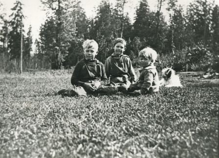
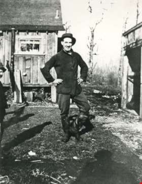
Haddon Family
https://search.heritageburnaby.ca/link/archivedescription35566
- Repository
- City of Burnaby Archives
- Date
- 1922 (date of original), copied 1986
- Collection/Fonds
- Burnaby Historical Society fonds
- Description Level
- Item
- Physical Description
- 1 photograph : b&w ; 12.7 x 17.8 cm print
- Scope and Content
- Photograph of Haddon family boys. Left to right: Gordon Haddon (brother), Jimmy Haddon (cousin), and Douglas Haddon (brother). This photo was taken looking south from behind the family home at 7870 Government Road between Lozells Avenue and Piper Avenue.
- Repository
- City of Burnaby Archives
- Date
- 1922 (date of original), copied 1986
- Collection/Fonds
- Burnaby Historical Society fonds
- Subseries
- Pioneer Tales subseries
- Physical Description
- 1 photograph : b&w ; 12.7 x 17.8 cm print
- Description Level
- Item
- Record No.
- 204-424
- Access Restriction
- No restrictions
- Reproduction Restriction
- No known restrictions
- Accession Number
- BHS1988-03
- Scope and Content
- Photograph of Haddon family boys. Left to right: Gordon Haddon (brother), Jimmy Haddon (cousin), and Douglas Haddon (brother). This photo was taken looking south from behind the family home at 7870 Government Road between Lozells Avenue and Piper Avenue.
- Subjects
- Animals - Dogs
- Media Type
- Photograph
- Notes
- Title based on contents of photograph
- Geographic Access
- Government Road
- Street Address
- 7870 Government Road
- Historic Neighbourhood
- Lozells (Historic Neighbourhood)
- Planning Study Area
- Government Road Area
Images

Haddon family
https://search.heritageburnaby.ca/link/archivedescription35568
- Repository
- City of Burnaby Archives
- Date
- 1925 (date of original), copied 1986
- Collection/Fonds
- Burnaby Historical Society fonds
- Description Level
- Item
- Physical Description
- 1 photograph : b&w ; 12.7 x 17.8 cm print
- Scope and Content
- Photograph of (left) Gordon Haddon and (right) Jimmy Haddon, his cousin, at Burnaby Lake where Eagle Creek flows into it. At the left is the dock at the foot of Piper Avenue. The water was deep and good for swimming.
- Repository
- City of Burnaby Archives
- Date
- 1925 (date of original), copied 1986
- Collection/Fonds
- Burnaby Historical Society fonds
- Subseries
- Pioneer Tales subseries
- Physical Description
- 1 photograph : b&w ; 12.7 x 17.8 cm print
- Description Level
- Item
- Record No.
- 204-426
- Access Restriction
- No restrictions
- Reproduction Restriction
- No known restrictions
- Accession Number
- BHS1988-03
- Scope and Content
- Photograph of (left) Gordon Haddon and (right) Jimmy Haddon, his cousin, at Burnaby Lake where Eagle Creek flows into it. At the left is the dock at the foot of Piper Avenue. The water was deep and good for swimming.
- Subjects
- Geographic Features - Lakes and Ponds
- Geographic Features - Creeks
- Structures - Piers and Wharves
- Sports - Swimming
- Names
- Haddon, Gordon
- Haddon, Jimmy
- Media Type
- Photograph
- Notes
- Title based on contents of photograph
- Geographic Access
- Burnaby Lake
- Piper Avenue
- Eagle Creek
- Historic Neighbourhood
- Lozells (Historic Neighbourhood)
- Planning Study Area
- Government Road Area
Images


Interview with Robert Lowe by Eric Damer November 5, 2012 - Track 2
https://search.heritageburnaby.ca/link/oralhistory354
- Repository
- City of Burnaby Archives
- Date Range
- 1939-2012
- Length
- 0:09:13
- Summary
- This portion of the recording pertains to Robert "Bob" Lowe's memories of the development of property Burnaby. He discusses houses being built by his father, grandfather and himself; this includes the property that he and his wife bought in 1961. Bob also discusses the rise of the automobile.
- Repository
- City of Burnaby Archives
- Summary
- This portion of the recording pertains to Robert "Bob" Lowe's memories of the development of property Burnaby. He discusses houses being built by his father, grandfather and himself; this includes the property that he and his wife bought in 1961. Bob also discusses the rise of the automobile.
- Date Range
- 1939-2012
- Photo Info
- Robert "Bob" Lowe (at center) and friends riding soap box race cars, [1939]. Item no. 549-041.
- Length
- 0:09:13
- Planning Study Area
- Government Road Area
- Interviewer
- Damer, Eric
- Interview Date
- November 5, 2012
- Scope and Content
- Recording is an interview with Robert "Bob" Lowe conducted by Burnaby Village Museum employee Eric Damer, November 5, 2012. Major theme discussed: the rise of the automobile and its effect on development in Burnaby.
- Biographical Notes
- Robert "Bob" Lowe has lived his entire life in Burnaby. During his childhood, Bob’s family lived at several addresses near Royal Oak and what is now Canada Way. He attended Douglas Road Elementary and South Burnaby High Schools. After graduating, Bob worked for a few years before enrolling in Normal School for a teaching certificate. He began teaching in Vancouver, married in 1952, and started a family. The Lowes moved to Government Road in 1961 and began a hobby farm, while Bob upgraded his formal education and became an administrator in the new college system.
- Total Tracks
- 4
- Total Length
- 0:36:54
- Interviewee Name
- Lowe, Robert "Bob"
- Interview Location
- Interviewee's residence
- Interviewer Bio
- Eric Damer is a lifelong British Columbian born in Victoria, raised in Kamloops, and currently residing in Burnaby. After studying philosophy at the University of Victoria, he became interested in the educational forces that had shaped his own life. He completed master’s and doctoral degrees in educational studies at the University of British Columbia with a particular interest in the history of adult and higher education in the province. In 2012, Eric worked for the City of Burnaby as a field researcher and writer, conducting interviews for the City Archives and Museum Oral History Program.
- Collection/Fonds
- Community Heritage Commission Special Projects fonds
- Transcript Available
- None
- Media Type
- Sound Recording
Images

Audio Tracks
Track two of recording of interview with Bob Lowe
Track two of recording of interview with Bob Lowe
https://search.heritageburnaby.ca/media/hpo/_Data/_Archives_Oral_Histories/_Unrestricted/MSS171-016/MSS171-016_Track_2.mp3
Lozells Community Hall near completion
https://search.heritageburnaby.ca/link/archivedescription36422
- Repository
- City of Burnaby Archives
- Date
- 1922
- Collection/Fonds
- Burnaby Historical Society fonds
- Description Level
- Item
- Physical Description
- 1 photograph : col. ; 7 x 11 cm print
- Scope and Content
- Photograph of the Lozells Community Hall near completion.
- Repository
- City of Burnaby Archives
- Date
- 1922
- Collection/Fonds
- Burnaby Historical Society fonds
- Subseries
- Photographs subseries
- Physical Description
- 1 photograph : col. ; 7 x 11 cm print
- Description Level
- Item
- Record No.
- 267-003
- Access Restriction
- No restrictions
- Reproduction Restriction
- No known restrictions
- Accession Number
- BHS1991-34
- Scope and Content
- Photograph of the Lozells Community Hall near completion.
- Media Type
- Photograph
- Notes
- Title based on contents of photograph
- Print is a colour copy of a sepia original
- Geographic Access
- Lozells Avenue
- Government Road
- Historic Neighbourhood
- Lozells (Historic Neighbourhood)
- Planning Study Area
- Government Road Area
Images

![Mr. and Mrs. Orville E. Butler, [193-] thumbnail](/media/hpo/_Data/_BVM_Images/1983/198300420005.jpg?width=280)
Mr. and Mrs. Orville E. Butler
https://search.heritageburnaby.ca/link/museumdescription284
- Repository
- Burnaby Village Museum
- Date
- [193-]
- Collection/Fonds
- Burnaby Village Museum Photograph collection
- Description Level
- Item
- Physical Description
- 1 photograph : b&w ; 9.7 x 14.9 cm
- Scope and Content
- Photograph of Mr. and Mrs. Orville E. Butler in front of their house. They are standing with an unidentified man in suit pants, shirt and a tie that is blowing in the wind. In the back, nearer the house, there is a table with tea cups arranged on it. Mr. Orville is wearing glasses, suspenders and a…
- Repository
- Burnaby Village Museum
- Collection/Fonds
- Burnaby Village Museum Photograph collection
- Description Level
- Item
- Physical Description
- 1 photograph : b&w ; 9.7 x 14.9 cm
- Scope and Content
- Photograph of Mr. and Mrs. Orville E. Butler in front of their house. They are standing with an unidentified man in suit pants, shirt and a tie that is blowing in the wind. In the back, nearer the house, there is a table with tea cups arranged on it. Mr. Orville is wearing glasses, suspenders and a pocket watch by his waist. The Butlers lived at 8006 Government Road.
- History
- Orval (or Orville) Elsworth Butler married Florena (or Floriana) Birdin 1928. He worked as a a cabinet maker and carpenter while she worked as a clerk until her marriage at age 44. Orval's first wife was named Catharine. Orval and Florena moved to Burnaby in the 1930s. Orval died at age 79 in 1941. Florena died in 1973 at age 90. Orval Butler likely built a house at 8006 Government Rd with his first wife, Catherine. Florena later lived in the house.
- Geographic Access
- Government Road
- Street Address
- 8006 Government Road
- Accession Code
- HV983.42.5
- Access Restriction
- No restrictions
- Reproduction Restriction
- No known restrictions
- Date
- [193-]
- Media Type
- Photograph
- Historic Neighbourhood
- Lozells (Historic Neighbourhood)
- Planning Study Area
- Government Road Area
- Scan Resolution
- 600
- Scan Date
- 2023-09-12
- Notes
- Title based on contents of photograph
- The accession register notes the house is located at 8006 Government Road (Address prior to 1959: 806 Government Road). A note in the accession file explains Mr. and Mrs. Butler built their own house on Government Road in 1930 or 1931.
Images
![Mr. and Mrs. Orville E. Butler, [193-] thumbnail](/media/hpo/_Data/_BVM_Images/1983/198300420005.jpg)

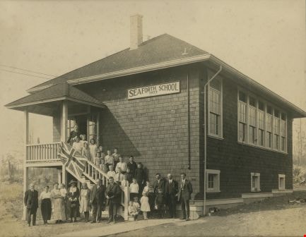
Opening day of Seaforth School in Burnaby
https://search.heritageburnaby.ca/link/archivedescription36608
- Repository
- City of Burnaby Archives
- Date
- 1922
- Collection/Fonds
- Burnaby Historical Society fonds
- Description Level
- Item
- Physical Description
- 1 photograph : sepia ; 18.5 x 23.5 cm (sight) in mat 30 x 35 cm
- Scope and Content
- Photograph of the official opening of Seaforth School on Government Road at Piper Avenue. Teachers, students, parents and staff are all standing on the steps of the school as well as in a long row out front. Individuals have been identified as; (from top of stairs) the school's first teacher Mrs. P…
- Repository
- City of Burnaby Archives
- Date
- 1922
- Collection/Fonds
- Burnaby Historical Society fonds
- Subseries
- J.P. Dickson subseries
- Physical Description
- 1 photograph : sepia ; 18.5 x 23.5 cm (sight) in mat 30 x 35 cm
- Description Level
- Item
- Record No.
- 308-001
- Access Restriction
- No restrictions
- Reproduction Restriction
- No known restrictions
- Accession Number
- BHS1992-51
- Scope and Content
- Photograph of the official opening of Seaforth School on Government Road at Piper Avenue. Teachers, students, parents and staff are all standing on the steps of the school as well as in a long row out front. Individuals have been identified as; (from top of stairs) the school's first teacher Mrs. Postill, (next step, left to right) [unidentified], Evelyn Jenkins, (next step) Dorothy Pipe, Myrtle Jackson, (next step) [unidentified], (next step) Beulah Tobaert, [unidentified], [unidentified], (next step) Madaleine Tobaert, Stewart Pipe, Arthur Haddon, (next step) [unidentified], [unidentified], Gordon Haddon, Russell Pipe, (next step) Jimmie Haddon, Douglas Haddon, George Johnston. Seated on the bottom steps are; unidentified and Douglas Haddon. Standing on the ground to the right of the seated boys are; (back row) [unidentified], [looks to be Claude Hill], [unidentified]. Standing in front of them are Kathleen Pipe, [unidentified] and Jack Jenkins. Standing on the ground to the left of the staircase are all unidentified except for the woman wearing a hat who has been identified as Mrs. Haddon (Myrtle and Jimmie's mom).The school building was later moved to Burnaby Village Museum.
- Subjects
- Occupations - Teachers
- Names
- Seaforth School
- Media Type
- Photograph
- Notes
- Title based on contents of photograph
- Item no. BV985.6022.2 is a laser copy of this original
- Individuals were identified from handwritten notes on recto of item BV985.6022.2 (laser copy of original)
- Geographic Access
- Government Road
- Deer Lake Avenue
- Street Address
- 7881 Government Road
- 6501 Deer Lake Avenue
- Historic Neighbourhood
- Lozells (Historic Neighbourhood)
- Planning Study Area
- Government Road Area
Images
![Orville E. Butler at his house, [193-] thumbnail](/media/hpo/_Data/_BVM_Images/1983/198300420006.jpg?width=280)
Orville E. Butler at his house
https://search.heritageburnaby.ca/link/museumdescription285
- Repository
- Burnaby Village Museum
- Date
- [193-]
- Collection/Fonds
- Burnaby Village Museum Photograph collection
- Description Level
- Item
- Physical Description
- 1 photograph : b&w ; 20.0 x 25.2 cm
- Scope and Content
- Photograph of the Butler family house at 8006 Government Road. On the lawn, Orville E. Butler and a young woman with a hat, possibly his daughter, are sitting on a bench, looking towards the photographer.
- Repository
- Burnaby Village Museum
- Collection/Fonds
- Burnaby Village Museum Photograph collection
- Description Level
- Item
- Physical Description
- 1 photograph : b&w ; 20.0 x 25.2 cm
- Scope and Content
- Photograph of the Butler family house at 8006 Government Road. On the lawn, Orville E. Butler and a young woman with a hat, possibly his daughter, are sitting on a bench, looking towards the photographer.
- Subjects
- Buildings - Residential - Houses
- Names
- Butler, Orville E.
- Geographic Access
- Government Road
- Street Address
- 8006 Government Road
- Accession Code
- HV983.42.6
- Access Restriction
- No restrictions
- Reproduction Restriction
- No known restrictions
- Date
- [193-]
- Media Type
- Photograph
- Historic Neighbourhood
- Lozells (Historic Neighbourhood)
- Planning Study Area
- Government Road Area
- Scan Resolution
- 600
- Scan Date
- 2023-09-12
- Notes
- Title based on contents of photograph
- 1 smaller b&w photograph accompanying
Images
![Orville E. Butler at his house, [193-] thumbnail](/media/hpo/_Data/_BVM_Images/1983/198300420006.jpg)
![Orville E. Butler at his house, [193-] thumbnail](/media/hpo/_Data/_BVM_Images/1983/1983_0042_0007_a001.jpg?width=280)
Orville E. Butler at his house
https://search.heritageburnaby.ca/link/museumdescription286
- Repository
- Burnaby Village Museum
- Date
- [193-]
- Collection/Fonds
- Burnaby Village Museum Photograph collection
- Description Level
- Item
- Physical Description
- 1 photograph : b&w ; 17.5 x 22 cm
- Scope and Content
- Photograph of the Butler family house at 8006 Government Road. On the lawn, Mr. Orville E. Butler and a young woman with a hat, possibly his daughter, are sitting on a bench, looking towards the photographer.
- Repository
- Burnaby Village Museum
- Collection/Fonds
- Burnaby Village Museum Photograph collection
- Description Level
- Item
- Physical Description
- 1 photograph : b&w ; 17.5 x 22 cm
- Scope and Content
- Photograph of the Butler family house at 8006 Government Road. On the lawn, Mr. Orville E. Butler and a young woman with a hat, possibly his daughter, are sitting on a bench, looking towards the photographer.
- Subjects
- Buildings - Residential - Houses
- Names
- Butler, Orville E.
- Geographic Access
- Government Road
- Street Address
- 8006 Government Road
- Accession Code
- HV983.42.7
- Access Restriction
- No restrictions
- Reproduction Restriction
- No known restrictions
- Date
- [193-]
- Media Type
- Photograph
- Historic Neighbourhood
- Lozells (Historic Neighbourhood)
- Planning Study Area
- Government Road Area
- Scan Resolution
- 600
- Scan Date
- 2023-09-12
- Notes
- Title based on contents of photograph
Images
![Orville E. Butler at his house, [193-] thumbnail](/media/hpo/_Data/_BVM_Images/1983/1983_0042_0007_a001.jpg)
Robert Haddon
https://search.heritageburnaby.ca/link/archivedescription35565
- Repository
- City of Burnaby Archives
- Date
- 1924 (date of original), copied 1986
- Collection/Fonds
- Burnaby Historical Society fonds
- Description Level
- Item
- Physical Description
- 1 photograph : b&w ; 12.7 x 17.8 cm print
- Scope and Content
- Photograph of Robert Haddon at the back of the family home at 7870 Government Road between Lozells Avenue and Piper Avenue.
- Repository
- City of Burnaby Archives
- Date
- 1924 (date of original), copied 1986
- Collection/Fonds
- Burnaby Historical Society fonds
- Subseries
- Pioneer Tales subseries
- Physical Description
- 1 photograph : b&w ; 12.7 x 17.8 cm print
- Description Level
- Item
- Record No.
- 204-423
- Access Restriction
- No restrictions
- Reproduction Restriction
- No known restrictions
- Accession Number
- BHS1988-03
- Scope and Content
- Photograph of Robert Haddon at the back of the family home at 7870 Government Road between Lozells Avenue and Piper Avenue.
- Names
- Haddon, Robert
- Media Type
- Photograph
- Notes
- Title based on contents of photograph
- Geographic Access
- Government Road
- Street Address
- 7870 Government Road
- Historic Neighbourhood
- Lozells (Historic Neighbourhood)
- Planning Study Area
- Government Road Area
Images


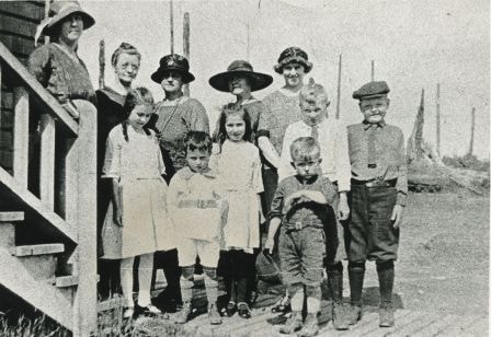
Seaforth School
https://search.heritageburnaby.ca/link/archivedescription35563
- Repository
- City of Burnaby Archives
- Date
- 1922 (date of original), copied 1986
- Collection/Fonds
- Burnaby Historical Society fonds
- Description Level
- Item
- Physical Description
- 1 photograph : b&w ; 12.7 x 17.8 cm print
- Scope and Content
- Photograph of Seaforth School parents, teacher, and students. Identified: (far left) Mrs. Jean Ker Haddon (mother); (2nd from right) Gordon Haddon. Teacher: Miss Postill (not identified). Taken at Seaforth school in 1922, the year it was built. The reprised schoolhouse was later relocated to Burna…
- Repository
- City of Burnaby Archives
- Date
- 1922 (date of original), copied 1986
- Collection/Fonds
- Burnaby Historical Society fonds
- Subseries
- Pioneer Tales subseries
- Physical Description
- 1 photograph : b&w ; 12.7 x 17.8 cm print
- Description Level
- Item
- Record No.
- 204-421
- Access Restriction
- No restrictions
- Reproduction Restriction
- No known restrictions
- Accession Number
- BHS1988-03
- Scope and Content
- Photograph of Seaforth School parents, teacher, and students. Identified: (far left) Mrs. Jean Ker Haddon (mother); (2nd from right) Gordon Haddon. Teacher: Miss Postill (not identified). Taken at Seaforth school in 1922, the year it was built. The reprised schoolhouse was later relocated to Burnaby Village Museum.
- Subjects
- Occupations - Teachers
- Media Type
- Photograph
- Notes
- Title based on contents of photograph
- Geographic Access
- Government Road
- Deer Lake Avenue
- Street Address
- 7881 Government Road
- 6501 Deer Lake Avenue
- Historic Neighbourhood
- Lozells (Historic Neighbourhood)
- Planning Study Area
- Government Road Area
Images