Narrow Results By
Subject
- Buildings - Commercial - Hardware Stores 1
- Buildings - Heritage 3
- Buildings - Industrial - Factories 3
- Buildings - Residential - Houses 6
- Buildings - Residential - Seniors Housing 1
- Geographic Features - Gardens 1
- Geographic Features - Parks 1
- Geographic Features - Trails 1
- Land Clearing 2
- Transportation - Automobiles 1
![Brookes family home, [1920] (date of original), copied 1986 thumbnail](/media/hpo/_Data/_Archives_Images/_Unrestricted/204/204-102.jpg?width=280)
Brookes family home
https://search.heritageburnaby.ca/link/archivedescription35245
- Repository
- City of Burnaby Archives
- Date
- [1920] (date of original), copied 1986
- Collection/Fonds
- Burnaby Historical Society fonds
- Description Level
- Item
- Physical Description
- 1 photograph : b&w ; 12.7 x 17.8 cm print
- Scope and Content
- Photograph of the Brookes family home at 441 12th Avenue (later renumbered 7979 12th Avenue), at the corner of 4th Street in East Burnaby. The Brookes family, headed by James Brookes, moved into this house in 1917. The house was later cut in two and moved to another part of the lot, becoming a gard…
- Repository
- City of Burnaby Archives
- Date
- [1920] (date of original), copied 1986
- Collection/Fonds
- Burnaby Historical Society fonds
- Subseries
- Pioneer Tales subseries
- Physical Description
- 1 photograph : b&w ; 12.7 x 17.8 cm print
- Description Level
- Item
- Record No.
- 204-102
- Access Restriction
- No restrictions
- Reproduction Restriction
- No known restrictions
- Accession Number
- BHS1988-03
- Scope and Content
- Photograph of the Brookes family home at 441 12th Avenue (later renumbered 7979 12th Avenue), at the corner of 4th Street in East Burnaby. The Brookes family, headed by James Brookes, moved into this house in 1917. The house was later cut in two and moved to another part of the lot, becoming a gardener's house in 1927 when "Normanna" was built. Note the greenhouse in front of the house. This house was built by Burnaby's first Reeve, Charles Shaw, and is now a designated heritage site at 7725 4th Street.
- Media Type
- Photograph
- Notes
- Title based on contents of photograph
- Geographic Access
- 4th Street
- Street Address
- 7725 4th Street
- Historic Neighbourhood
- East Burnaby (Historic Neighbourhood)
- Planning Study Area
- Second Street Area
Images
![Brookes family home, [1920] (date of original), copied 1986 thumbnail](/media/hpo/_Data/_Archives_Images/_Unrestricted/204/204-102.jpg)

Brookes family home, "Normanna"
https://search.heritageburnaby.ca/link/archivedescription35246
- Repository
- City of Burnaby Archives
- Date
- 1927
- Collection/Fonds
- Burnaby Historical Society fonds
- Description Level
- Item
- Physical Description
- 1 photograph : b&w ; 12.7 x 17.8 cm print
- Scope and Content
- Photograph of "Normanna," the Brookes family residence. This new Brookes family home was built in 1927 on the same site as the original house at 441 12th Avenue (later renumbered 7979 12th Avenue). Eventually, this became Normanna Norwegian rest home. The original house was built by Burnaby's firs…
- Repository
- City of Burnaby Archives
- Date
- 1927
- Collection/Fonds
- Burnaby Historical Society fonds
- Subseries
- Pioneer Tales subseries
- Physical Description
- 1 photograph : b&w ; 12.7 x 17.8 cm print
- Description Level
- Item
- Record No.
- 204-103
- Access Restriction
- No restrictions
- Reproduction Restriction
- No known restrictions
- Accession Number
- BHS1988-03
- Scope and Content
- Photograph of "Normanna," the Brookes family residence. This new Brookes family home was built in 1927 on the same site as the original house at 441 12th Avenue (later renumbered 7979 12th Avenue). Eventually, this became Normanna Norwegian rest home. The original house was built by Burnaby's first Reeve, Charles Shaw, and is now a designated heritage site at 7725 4th Street.
- Subjects
- Geographic Features - Gardens
- Buildings - Residential - Houses
- Buildings - Residential - Seniors Housing
- Buildings - Heritage
- Names
- Normanna Rest Home
- Media Type
- Photograph
- Notes
- Title based on contents of photograph
- Geographic Access
- 4th Street
- Street Address
- 7725 4th Street
- Historic Neighbourhood
- East Burnaby (Historic Neighbourhood)
- Planning Study Area
- Second Street Area
Images


Coldicutt house
https://search.heritageburnaby.ca/link/archivedescription36575
- Repository
- City of Burnaby Archives
- Date
- 1944
- Collection/Fonds
- Burnaby Historical Society fonds
- Description Level
- Item
- Physical Description
- 1 photograph : sepia ; 7 x 5 cm
- Scope and Content
- Photograph of the front of the Coldicutt House located at 6th Street and 16th Avenue.
- Repository
- City of Burnaby Archives
- Date
- 1944
- Collection/Fonds
- Burnaby Historical Society fonds
- Subseries
- Pixie McGeachie subseries
- Physical Description
- 1 photograph : sepia ; 7 x 5 cm
- Description Level
- Item
- Record No.
- 299-001
- Access Restriction
- No restrictions
- Reproduction Restriction
- No known restrictions
- Accession Number
- BHS1992-39
- Scope and Content
- Photograph of the front of the Coldicutt House located at 6th Street and 16th Avenue.
- Subjects
- Buildings - Residential - Houses
- Media Type
- Photograph
- Notes
- Title based on contents of photograph
- Geographic Access
- 6th Street
- Street Address
- 7510 6th Street
- Historic Neighbourhood
- East Burnaby (Historic Neighbourhood)
- Planning Study Area
- Second Street Area
Images

![James Brooke's house, [1925] thumbnail](/media/hpo/_Data/_BVM_Images/1984/1984_0056_0001_001.jpg?width=280)
James Brooke's house
https://search.heritageburnaby.ca/link/museumdescription278
- Repository
- Burnaby Village Museum
- Date
- [1925]
- Collection/Fonds
- Burnaby Village Museum Photograph collection
- Description Level
- Item
- Physical Description
- 1 photograph : b&w ; 6.9 x 11.5 cm
- Scope and Content
- Photograph of a two storey house with a basement built on a large lawn. There are flower beds on the lawn and a fence around the backyard. A neighboring house and the woods are visible in the background. According to the donor form, the photograph depicts James Brooke's house on 12th Avenue in Bu…
- Repository
- Burnaby Village Museum
- Collection/Fonds
- Burnaby Village Museum Photograph collection
- Description Level
- Item
- Physical Description
- 1 photograph : b&w ; 6.9 x 11.5 cm
- Scope and Content
- Photograph of a two storey house with a basement built on a large lawn. There are flower beds on the lawn and a fence around the backyard. A neighboring house and the woods are visible in the background. According to the donor form, the photograph depicts James Brooke's house on 12th Avenue in Burnaby, built by G. Moxham and Company. At the time of the donation, the house was owned by Normanna Rest Home. "
- Subjects
- Buildings - Residential - Houses
- Names
- Normanna Rest Home
- Geographic Access
- 4th Street
- Street Address
- 7725 4th Street
- Accession Code
- HV984.56.1
- Access Restriction
- No restrictions
- Reproduction Restriction
- No known restrictions
- Date
- [1925]
- Media Type
- Photograph
- Historic Neighbourhood
- East Burnaby (Historic Neighbourhood)
- Planning Study Area
- Second Street Area
- Scan Resolution
- 600
- Scan Date
- 2023-11-07
- Notes
- Title based on contents of photograph
- The annotation on verso of photo reads: "Home of James Brookes / (Normanna) now. / Built by G. Moxham & Co. / 1944 Sixth St. Burnaby. / built in early 20's - '22-'24?" Stamped on the back of the photo: "100.
Images
![James Brooke's house, [1925] thumbnail](/media/hpo/_Data/_BVM_Images/1984/1984_0056_0001_001.jpg)
![Lois Hollands-Coutts and Charles Hollands, [1945] (date of original), copied 1991 thumbnail](/media/hpo/_Data/_Archives_Images/_Unrestricted/370/370-429.jpg?width=280)
Lois Hollands-Coutts and Charles Hollands
https://search.heritageburnaby.ca/link/archivedescription37841
- Repository
- City of Burnaby Archives
- Date
- [1945] (date of original), copied 1991
- Collection/Fonds
- Burnaby Historical Society fonds
- Description Level
- Item
- Physical Description
- 1 photograph : b&w ; 4.1 x 2.8 cm print on contact sheet 20.6 x 26.7 cm
- Scope and Content
- Photograph of Lois Holland-Coutts and her father, Charles Hollands, on a path leading to Robert Burnaby Park, near 6th Street at 19th Avenue.
- Repository
- City of Burnaby Archives
- Date
- [1945] (date of original), copied 1991
- Collection/Fonds
- Burnaby Historical Society fonds
- Subseries
- Burnaby Image Bank subseries
- Physical Description
- 1 photograph : b&w ; 4.1 x 2.8 cm print on contact sheet 20.6 x 26.7 cm
- Description Level
- Item
- Record No.
- 370-429
- Access Restriction
- No restrictions
- Reproduction Restriction
- No known restrictions
- Accession Number
- BHS1999-03
- Scope and Content
- Photograph of Lois Holland-Coutts and her father, Charles Hollands, on a path leading to Robert Burnaby Park, near 6th Street at 19th Avenue.
- Media Type
- Photograph
- Notes
- Title based on contents of photograph
- 1 b&w copy negative accompanying
- Negative has a pink cast
- Geographic Access
- 6th Street
- 19th Avenue
- Historic Neighbourhood
- East Burnaby (Historic Neighbourhood)
- Planning Study Area
- Second Street Area
Images
![Lois Hollands-Coutts and Charles Hollands, [1945] (date of original), copied 1991 thumbnail](/media/hpo/_Data/_Archives_Images/_Unrestricted/370/370-429.jpg)
![Lot clearing for Westminster Gospel Chapel, [between 1945 and 1949] (date of original), copied 1991 thumbnail](/media/hpo/_Data/_Archives_Images/_Unrestricted/370/370-415.jpg?width=280)
Lot clearing for Westminster Gospel Chapel
https://search.heritageburnaby.ca/link/archivedescription37827
- Repository
- City of Burnaby Archives
- Date
- [between 1945 and 1949] (date of original), copied 1991
- Collection/Fonds
- Burnaby Historical Society fonds
- Description Level
- Item
- Physical Description
- 1 photograph : b&w ; 2.7 x 4.7 cm print on contact sheet 20.6 x 26.2 cm
- Scope and Content
- Photograph of people clearing a lot to build Westminster Gospel Chapel at 7540 6th Street.
- Repository
- City of Burnaby Archives
- Date
- [between 1945 and 1949] (date of original), copied 1991
- Collection/Fonds
- Burnaby Historical Society fonds
- Subseries
- Burnaby Image Bank subseries
- Physical Description
- 1 photograph : b&w ; 2.7 x 4.7 cm print on contact sheet 20.6 x 26.2 cm
- Description Level
- Item
- Record No.
- 370-415
- Access Restriction
- No restrictions
- Reproduction Restriction
- No known restrictions
- Accession Number
- BHS1999-03
- Scope and Content
- Photograph of people clearing a lot to build Westminster Gospel Chapel at 7540 6th Street.
- Subjects
- Land Clearing
- Media Type
- Photograph
- Notes
- Title based on contents of photograph
- 1 b&w copy negative accompanying
- Negative has a pink cast
- Geographic Access
- 6th Street
- Street Address
- 7540 6th Street
- Historic Neighbourhood
- East Burnaby (Historic Neighbourhood)
- Planning Study Area
- Second Street Area
Images
![Lot clearing for Westminster Gospel Chapel, [between 1945 and 1949] (date of original), copied 1991 thumbnail](/media/hpo/_Data/_Archives_Images/_Unrestricted/370/370-415.jpg)
![Lot clearing for Westminster Gospel Chapel, [between 1945 and 1949] (date of original), copied 1991 thumbnail](/media/hpo/_Data/_Archives_Images/_Unrestricted/370/370-416.jpg?width=280)
Lot clearing for Westminster Gospel Chapel
https://search.heritageburnaby.ca/link/archivedescription37828
- Repository
- City of Burnaby Archives
- Date
- [between 1945 and 1949] (date of original), copied 1991
- Collection/Fonds
- Burnaby Historical Society fonds
- Description Level
- Item
- Physical Description
- 1 photograph : b&w ; 2.6 x 4.7 cm print on contact sheet 20.6 x 26.2 cm
- Scope and Content
- Photograph of people clearing a lot to build Westminster Gospel Chapel at 7540 6th Street. Houses can be seen in the background, and the road can be seen in the foreground.
- Repository
- City of Burnaby Archives
- Date
- [between 1945 and 1949] (date of original), copied 1991
- Collection/Fonds
- Burnaby Historical Society fonds
- Subseries
- Burnaby Image Bank subseries
- Physical Description
- 1 photograph : b&w ; 2.6 x 4.7 cm print on contact sheet 20.6 x 26.2 cm
- Description Level
- Item
- Record No.
- 370-416
- Access Restriction
- No restrictions
- Reproduction Restriction
- No known restrictions
- Accession Number
- BHS1999-03
- Scope and Content
- Photograph of people clearing a lot to build Westminster Gospel Chapel at 7540 6th Street. Houses can be seen in the background, and the road can be seen in the foreground.
- Subjects
- Land Clearing
- Media Type
- Photograph
- Notes
- Title based on contents of photograph
- 1 b&w copy negative accompanying
- Negative has a pink cast
- Geographic Access
- 6th Street
- Street Address
- 7540 6th Street
- Historic Neighbourhood
- East Burnaby (Historic Neighbourhood)
- Planning Study Area
- Second Street Area
Images
![Lot clearing for Westminster Gospel Chapel, [between 1945 and 1949] (date of original), copied 1991 thumbnail](/media/hpo/_Data/_Archives_Images/_Unrestricted/370/370-416.jpg)

Moxham family house
https://search.heritageburnaby.ca/link/archivedescription34818
- Repository
- City of Burnaby Archives
- Date
- 1929
- Collection/Fonds
- Burnaby Historical Society fonds
- Description Level
- Item
- Physical Description
- 1 photograph : b&w ; 7.0 x 11.5 cm
- Scope and Content
- Photograph of the exterior of the Moxham family house at 1944 6th Street (later renumbered 7337 6th Street). This house was built in 1914 by Mr. Godfrey Moxham.
- Repository
- City of Burnaby Archives
- Date
- 1929
- Collection/Fonds
- Burnaby Historical Society fonds
- Subseries
- Kathleen Moore family subseries
- Physical Description
- 1 photograph : b&w ; 7.0 x 11.5 cm
- Description Level
- Item
- Record No.
- 139-001
- Access Restriction
- No restrictions
- Reproduction Restriction
- No known restrictions
- Accession Number
- BHS1985-09
- Scope and Content
- Photograph of the exterior of the Moxham family house at 1944 6th Street (later renumbered 7337 6th Street). This house was built in 1914 by Mr. Godfrey Moxham.
- Subjects
- Buildings - Residential - Houses
- Media Type
- Photograph
- Notes
- Title based on contents of photograph
- Geographic Access
- 6th Street
- Street Address
- 7337 6th Street
- Historic Neighbourhood
- East Burnaby (Historic Neighbourhood)
- Planning Study Area
- Edmonds Area
Images

![Moxham residence, [1929] (date of original) copied [2000] thumbnail](/media/hpo/_Data/_Archives_Images/_Unrestricted/371/388-001.jpg?width=280)
Moxham residence
https://search.heritageburnaby.ca/link/archivedescription38285
- Repository
- City of Burnaby Archives
- Date
- [1929] (date of original) copied [2000]
- Collection/Fonds
- Burnaby Historical Society fonds
- Description Level
- Item
- Physical Description
- 1 photograph : b&w ; 12.7 x 17.7 cm print
- Scope and Content
- Photograph of the Moxham residence, located at 1944 6th Street (old street numbering system). A note written on the back of the photograph reads: "Moxham residence, 1944 Sixth St., Burnaby. Built 1914 by Mr. Moxham. Photo taken ca. 1929."
- Repository
- City of Burnaby Archives
- Date
- [1929] (date of original) copied [2000]
- Collection/Fonds
- Burnaby Historical Society fonds
- Subseries
- Photographs subseries
- Physical Description
- 1 photograph : b&w ; 12.7 x 17.7 cm print
- Description Level
- Item
- Record No.
- 388-001
- Access Restriction
- No restrictions
- Reproduction Restriction
- No known restrictions
- Accession Number
- BHS2007-04
- Scope and Content
- Photograph of the Moxham residence, located at 1944 6th Street (old street numbering system). A note written on the back of the photograph reads: "Moxham residence, 1944 Sixth St., Burnaby. Built 1914 by Mr. Moxham. Photo taken ca. 1929."
- Media Type
- Photograph
- Notes
- Title based on caption
- Geographic Access
- 6th Street
- Historic Neighbourhood
- East Burnaby (Historic Neighbourhood)
- Planning Study Area
- Second Street Area
Images
![Moxham residence, [1929] (date of original) copied [2000] thumbnail](/media/hpo/_Data/_Archives_Images/_Unrestricted/371/388-001.jpg)
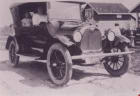
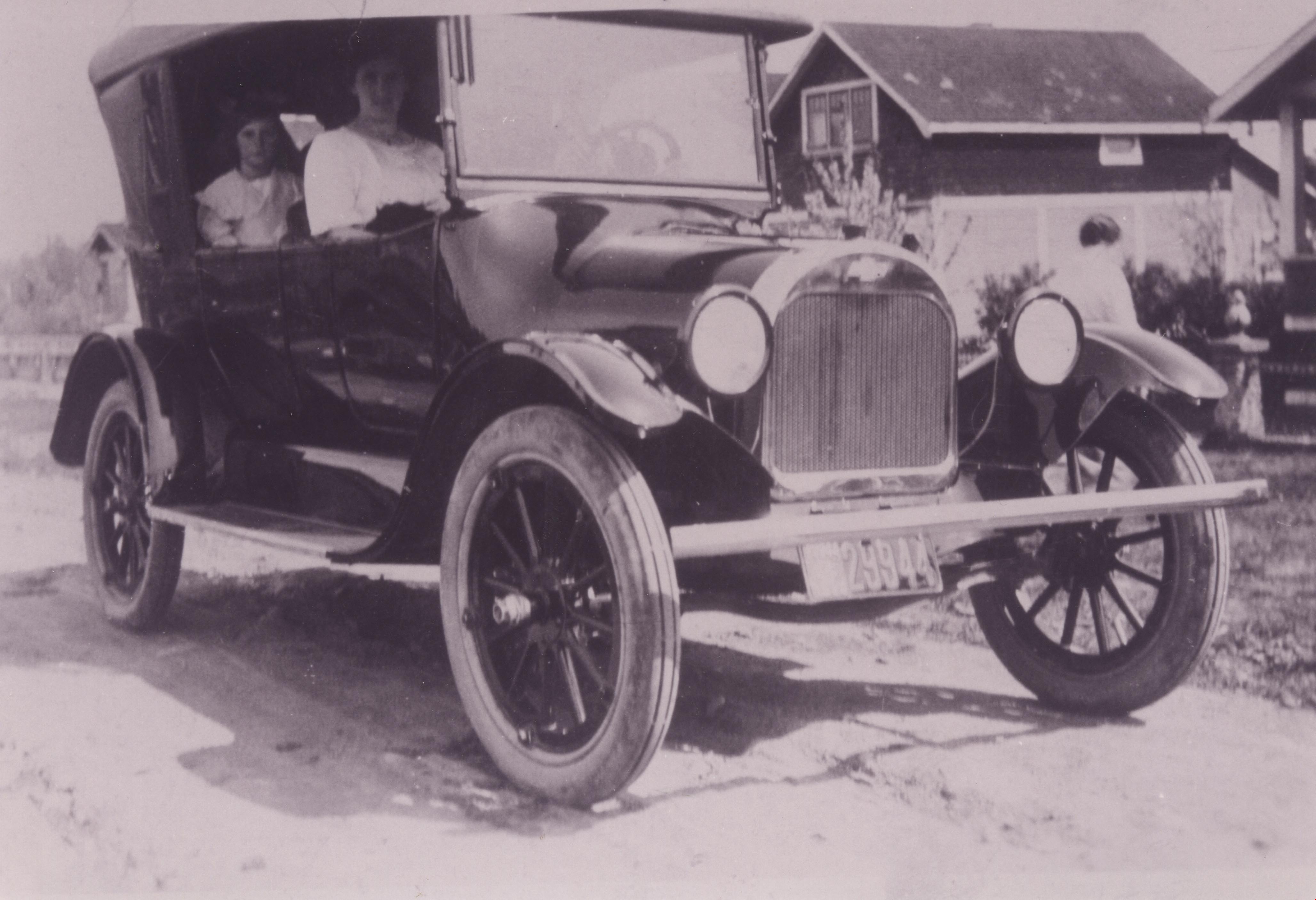
Pollard family car
https://search.heritageburnaby.ca/link/archivedescription37356
- Repository
- City of Burnaby Archives
- Date
- 1920 (date of original), copied 1998
- Collection/Fonds
- Burnaby Historical Society fonds
- Description Level
- Item
- Physical Description
- 1 photograph : b&w ; 12.8 x 17.5 cm print
- Scope and Content
- Photograph of the Pollard family's first car, a 1920-1922 Chevrolet Four-ninety Touring Car (so named because of selling price of $490.00). Agnes Pollard is sitting on the passenger side at the front and her May is sitting in the back. This photograph was likely taken near the family home at 17th A…
- Repository
- City of Burnaby Archives
- Date
- 1920 (date of original), copied 1998
- Collection/Fonds
- Burnaby Historical Society fonds
- Subseries
- Pollard family subseries
- Physical Description
- 1 photograph : b&w ; 12.8 x 17.5 cm print
- Description Level
- Item
- Record No.
- 359-002
- Access Restriction
- No restrictions
- Reproduction Restriction
- No known restrictions
- Accession Number
- BHS1998-09
- Scope and Content
- Photograph of the Pollard family's first car, a 1920-1922 Chevrolet Four-ninety Touring Car (so named because of selling price of $490.00). Agnes Pollard is sitting on the passenger side at the front and her May is sitting in the back. This photograph was likely taken near the family home at 17th Avenue and 4th Street.
- Subjects
- Transportation - Automobiles
- Media Type
- Photograph
- Notes
- Title based on contents of photograph.
- Geographic Access
- 17th Avenue
- 4th Street
- Historic Neighbourhood
- East Burnaby (Historic Neighbourhood)
- Planning Study Area
- Second Street Area
Images
![Whitechurch Hardware building, [between 1940 and 1945] thumbnail](/media/hpo/_Data/_BVM_Images/1995/1995_0029_0001_001.jpg?width=280)
Whitechurch Hardware building
https://search.heritageburnaby.ca/link/museumdescription1250
- Repository
- Burnaby Village Museum
- Date
- [between 1940 and 1945]
- Collection/Fonds
- Burnaby Village Museum Photograph collection
- Description Level
- Item
- Physical Description
- 1 photograph : sepia ; 10.5 x 5.5 cm
- Scope and Content
- Photograph of Maurice (Maury) Whitechurch standing at the door of Whitechurch Hardware Store with his mother in-law's springer spaniel, Peggy. Whitechurch Hardware was located at 1316 Sixth Street (later, 7685 Sixth Street) and in operation between 1937 and 1973. The building formerly housed Bell's…
- Repository
- Burnaby Village Museum
- Collection/Fonds
- Burnaby Village Museum Photograph collection
- Description Level
- Item
- Physical Description
- 1 photograph : sepia ; 10.5 x 5.5 cm
- Material Details
- Border of photograph has scalloped edges
- Scope and Content
- Photograph of Maurice (Maury) Whitechurch standing at the door of Whitechurch Hardware Store with his mother in-law's springer spaniel, Peggy. Whitechurch Hardware was located at 1316 Sixth Street (later, 7685 Sixth Street) and in operation between 1937 and 1973. The building formerly housed Bell's Dry Goods store until 1937 (with address 1314 Sixth Street) when it was moved slightly north to make room for a two storey building that was built on the corner, maintaining the address of 1314 Sixth Street. In 1974, this building was relocated to Burnaby Village Museum and restored to the former Bell's Dry Goods store.
- Names
- Whitechurch Hardware
- Geographic Access
- 6th Street
- Street Address
- 7685 6th Street
- 7695 6th Street
- Accession Code
- BV995.29.1
- Access Restriction
- No restrictions
- Reproduction Restriction
- No known restrictions
- Date
- [between 1940 and 1945]
- Media Type
- Photograph
- Historic Neighbourhood
- East Burnaby (Historic Neighbourhood)
- Planning Study Area
- Second Street Area
- Scan Resolution
- 600
- Scan Date
- 2024-05-22
- Notes
- Title based on contents of photograph
- Note on verso of photograph reads: "early 1940's"
Images
![Whitechurch Hardware building, [between 1940 and 1945] thumbnail](/media/hpo/_Data/_BVM_Images/1995/1995_0029_0001_001.jpg)
![Woodworking Plant, [192-] (date of original), copied 1986 thumbnail](/media/hpo/_Data/_Archives_Images/_Unrestricted/204/204-106.jpg?width=280)
Woodworking Plant
https://search.heritageburnaby.ca/link/archivedescription35249
- Repository
- City of Burnaby Archives
- Date
- [192-] (date of original), copied 1986
- Collection/Fonds
- Burnaby Historical Society fonds
- Description Level
- Item
- Physical Description
- 1 photograph : b&w ; 12.7 x 17.8 cm print
- Scope and Content
- Photograph of James Brookes Woodworking Plant located at 7730 6th Street. This site has also served as Cliff's Can Factory and Western Canadian Can Factory. Note the spur street car line (no. 2) where B.C. Electric Railway freight cars could load and unload.
- Repository
- City of Burnaby Archives
- Date
- [192-] (date of original), copied 1986
- Collection/Fonds
- Burnaby Historical Society fonds
- Subseries
- Pioneer Tales subseries
- Physical Description
- 1 photograph : b&w ; 12.7 x 17.8 cm print
- Description Level
- Item
- Record No.
- 204-106
- Access Restriction
- No restrictions
- Reproduction Restriction
- No known restrictions
- Accession Number
- BHS1988-03
- Scope and Content
- Photograph of James Brookes Woodworking Plant located at 7730 6th Street. This site has also served as Cliff's Can Factory and Western Canadian Can Factory. Note the spur street car line (no. 2) where B.C. Electric Railway freight cars could load and unload.
- Subjects
- Buildings - Industrial - Factories
- Media Type
- Photograph
- Notes
- Title based on contents of photograph
- Geographic Access
- 6th Street
- Street Address
- 7730 6th Street
- Historic Neighbourhood
- East Burnaby (Historic Neighbourhood)
- Planning Study Area
- Second Street Area
Images
![Woodworking Plant, [192-] (date of original), copied 1986 thumbnail](/media/hpo/_Data/_Archives_Images/_Unrestricted/204/204-106.jpg)
![Woodworking Plant, [192-] (date of original), copied 1986 thumbnail](/media/hpo/_Data/_Archives_Images/_Unrestricted/204/204-107.jpg?width=280)
Woodworking Plant
https://search.heritageburnaby.ca/link/archivedescription35250
- Repository
- City of Burnaby Archives
- Date
- [192-] (date of original), copied 1986
- Collection/Fonds
- Burnaby Historical Society fonds
- Description Level
- Item
- Physical Description
- 1 photograph : b&w ; 12.7 x 17.8 cm print
- Scope and Content
- Photograph of James Brookes Woodworking Plant, located at 7730 6th Street, taken from 13th Avenue. This site has also served as Cliff's Can Factory and Western Canadian Can Factory.
- Repository
- City of Burnaby Archives
- Date
- [192-] (date of original), copied 1986
- Collection/Fonds
- Burnaby Historical Society fonds
- Subseries
- Pioneer Tales subseries
- Physical Description
- 1 photograph : b&w ; 12.7 x 17.8 cm print
- Description Level
- Item
- Record No.
- 204-107
- Access Restriction
- No restrictions
- Reproduction Restriction
- No known restrictions
- Accession Number
- BHS1988-03
- Scope and Content
- Photograph of James Brookes Woodworking Plant, located at 7730 6th Street, taken from 13th Avenue. This site has also served as Cliff's Can Factory and Western Canadian Can Factory.
- Subjects
- Buildings - Industrial - Factories
- Media Type
- Photograph
- Notes
- Title based on contents of photograph
- Geographic Access
- 6th Street
- Street Address
- 7730 6th Street
- Historic Neighbourhood
- East Burnaby (Historic Neighbourhood)
- Planning Study Area
- Second Street Area
Images
![Woodworking Plant, [192-] (date of original), copied 1986 thumbnail](/media/hpo/_Data/_Archives_Images/_Unrestricted/204/204-107.jpg)
![Woodworking Plant, [192-] (date of original), copied 1986 thumbnail](/media/hpo/_Data/_Archives_Images/_Unrestricted/204/204-108.jpg?width=280)
Woodworking Plant
https://search.heritageburnaby.ca/link/archivedescription35251
- Repository
- City of Burnaby Archives
- Date
- [192-] (date of original), copied 1986
- Collection/Fonds
- Burnaby Historical Society fonds
- Description Level
- Item
- Physical Description
- 1 photograph : b&w ; 12.7 x 17.8 cm print
- Scope and Content
- Photograph of James Brookes Woodworking Plant, located at 7730 6th Street, taken from 6th Street. It was an East Burnaby landmark, established in 1902 as a can company by Edwin Cliff. This site has also served as Cliff's Can Factory and Western Canadian Can Factory.
- Repository
- City of Burnaby Archives
- Date
- [192-] (date of original), copied 1986
- Collection/Fonds
- Burnaby Historical Society fonds
- Subseries
- Pioneer Tales subseries
- Physical Description
- 1 photograph : b&w ; 12.7 x 17.8 cm print
- Description Level
- Item
- Record No.
- 204-108
- Access Restriction
- No restrictions
- Reproduction Restriction
- No known restrictions
- Accession Number
- BHS1988-03
- Scope and Content
- Photograph of James Brookes Woodworking Plant, located at 7730 6th Street, taken from 6th Street. It was an East Burnaby landmark, established in 1902 as a can company by Edwin Cliff. This site has also served as Cliff's Can Factory and Western Canadian Can Factory.
- Subjects
- Buildings - Industrial - Factories
- Media Type
- Photograph
- Notes
- Title based on contents of photograph
- Geographic Access
- 6th Street
- Street Address
- 7730 6th Street
- Historic Neighbourhood
- East Burnaby (Historic Neighbourhood)
- Planning Study Area
- Second Street Area
Images
![Woodworking Plant, [192-] (date of original), copied 1986 thumbnail](/media/hpo/_Data/_Archives_Images/_Unrestricted/204/204-108.jpg)