More like 'Venables Street'
Narrow Results By
Decade
- 2020s 129
- 2010s 127
- 2000s 751
- 1990s 729
- 1980s 531
- 1970s 1179
- 1960s 473
- 1950s 748
- 1940s 891
- 1930s 906
- 1920s 895
- 1910s
- 1900s 349
- 1890s 49
- 1880s 71
- 1870s 5
- 1860s 3
- 1850s 2
- 1840s 1
- 1830s 1
- 1820s 1
- 1810s 1
- 1800s 1
- 1790s 1
- 1780s 1
- 1770s 1
- 1760s 1
- 1750s 1
- 1740s 1
- 1730s 1
- 1720s 1
- 1710s 1
- 1700s 1
- 1690s 1
- 1680s 1
- 1670s 1
- 1660s 1
- 1650s 1
- 1640s 1
- 1630s 1
- 1620s 1
- 1610s 1
- 1600s 1
- 1520s 1
Subject
- Accidents 1
- Accidents - Train Accidents 1
- Advertising Medium - Signs and Signboards 7
- Agricultural Tools and Equipment 1
- Agricultural Tools and Equipment - Gardening Equipment 3
- Agricultural Tools and Equipment - Plows 3
- Agriculture - Crops 1
- Agriculture - Farms 9
- Animals - Birds 2
- Animals - Cats 2
- Animals - Cows 1
- Animals - Deer 1
Creator
- Barrowclough, G.A. 1
- BC Photo Card Company 1
- Brown, William Thomas 1
- Burnaby Village Museum 4
- Burnett and McGugan B.C. Land Surveyors, New Westminster 5
- Burnett, Geoffrey K. 3
- Burnett & McGugan, Engineers and Surveyors 22
- Canadian Pacific Railway Company 1
- Canadian Photo Company 12
- Challoner-Courtenay, E.J. 2
- Dean, H.M. 16
- Disney, John Harold "Jack" 32
![Stride family home, [between 1915 and 1920] thumbnail](/media/hpo/_Data/_Archives_Images/_Unrestricted/001/001-001.jpg?width=280)
Stride family home
https://search.heritageburnaby.ca/link/archivedescription34025
- Repository
- City of Burnaby Archives
- Date
- [between 1915 and 1920]
- Collection/Fonds
- Burnaby Historical Society fonds
- Description Level
- Item
- Physical Description
- 1 photograph : sepia postcard ; 8 x 14 cm
- Scope and Content
- Photographic postcard of the exterior of the Stride family home located at Kingsway and 18th Avenue. Two people are traveling in a Model T Ford (with the top down) along the street in front of the house.
- Repository
- City of Burnaby Archives
- Date
- [between 1915 and 1920]
- Collection/Fonds
- Burnaby Historical Society fonds
- Subseries
- Stride family subseries
- Physical Description
- 1 photograph : sepia postcard ; 8 x 14 cm
- Description Level
- Item
- Record No.
- 001-001
- Access Restriction
- No restrictions
- Reproduction Restriction
- No known restrictions
- Accession Number
- BHS2007-04
- Scope and Content
- Photographic postcard of the exterior of the Stride family home located at Kingsway and 18th Avenue. Two people are traveling in a Model T Ford (with the top down) along the street in front of the house.
- Subjects
- Buildings - Residential - Houses
- Documentary Artifacts - Postcards
- Transportation - Automobiles
- Media Type
- Photograph
- Notes
- Title based on contents of photograph
- Geographic Access
- Kingsway
- 18th Avenue
- Historic Neighbourhood
- Edmonds (Historic Neighbourhood)
Images
![Stride family home, [between 1915 and 1920] thumbnail](/media/hpo/_Data/_Archives_Images/_Unrestricted/001/001-001.jpg)
![W.F. Silver house, [ca. 1912] (date of original), copied 1986 thumbnail](/media/hpo/_Data/_Archives_Images/_Unrestricted/126/173-001.jpg?width=280)
W.F. Silver house
https://search.heritageburnaby.ca/link/archivedescription35006
- Repository
- City of Burnaby Archives
- Date
- [ca. 1912] (date of original), copied 1986
- Collection/Fonds
- Burnaby Historical Society fonds
- Description Level
- Item
- Physical Description
- 1 photograph : b&w ; 8.8 x 12.5 cm print
- Scope and Content
- Photograph of the exterior of the house of William F. Silver, Kingsway at Silver Avenue. An automobile, believed to be the family's 1911 Winton, is parked outside, and people are seated and standing on the right side of the photograph beside the house.
- Repository
- City of Burnaby Archives
- Date
- [ca. 1912] (date of original), copied 1986
- Collection/Fonds
- Burnaby Historical Society fonds
- Subseries
- Silver family subseries
- Physical Description
- 1 photograph : b&w ; 8.8 x 12.5 cm print
- Description Level
- Item
- Record No.
- 173-001
- Access Restriction
- No restrictions
- Reproduction Restriction
- No known restrictions
- Accession Number
- BHS1986-22
- Scope and Content
- Photograph of the exterior of the house of William F. Silver, Kingsway at Silver Avenue. An automobile, believed to be the family's 1911 Winton, is parked outside, and people are seated and standing on the right side of the photograph beside the house.
- Media Type
- Photograph
- Notes
- Title based on contents of photograph
- Geographic Access
- Kingsway
- Silver Avenue
- Historic Neighbourhood
- Central Park (Historic Neighbourhood)
- Planning Study Area
- Maywood Area
Images
![W.F. Silver house, [ca. 1912] (date of original), copied 1986 thumbnail](/media/hpo/_Data/_Archives_Images/_Unrestricted/126/173-001.jpg)

Boundary Road and Hastings Street vicinity
https://search.heritageburnaby.ca/link/archivedescription35447
- Repository
- City of Burnaby Archives
- Date
- 1915 (date of original), copied 1986
- Collection/Fonds
- Burnaby Historical Society fonds
- Description Level
- Item
- Physical Description
- 1 photograph : b&w ; 12.7 x 17.8 cm print
- Scope and Content
- Photograph taken in Vancouver on Hastings Street looking east toward Burnaby and Boundary Road. The Hastings Street British Columbia Electric Railway (BCER) cars can be seen labouring up the hill.
- Repository
- City of Burnaby Archives
- Date
- 1915 (date of original), copied 1986
- Collection/Fonds
- Burnaby Historical Society fonds
- Subseries
- Pioneer Tales subseries
- Physical Description
- 1 photograph : b&w ; 12.7 x 17.8 cm print
- Description Level
- Item
- Record No.
- 204-305
- Access Restriction
- No restrictions
- Reproduction Restriction
- No restrictions
- Accession Number
- BHS1988-03
- Scope and Content
- Photograph taken in Vancouver on Hastings Street looking east toward Burnaby and Boundary Road. The Hastings Street British Columbia Electric Railway (BCER) cars can be seen labouring up the hill.
- Media Type
- Photograph
- Photographer
- Eaton, Dr. Carl
- Notes
- Title based on contents of photograph
- Geographic Access
- Boundary Road
- Hastings Street
- Historic Neighbourhood
- Vancouver Heights (Historic Neighbourhood)
- Planning Study Area
- Willingdon Heights Area
Images

![Edmonds and Kingsway, 1912 (date of original), copied [1997] thumbnail](/media/hpo/_Data/_Archives_Images/_Unrestricted/316/350-015.jpg?width=280)
Edmonds and Kingsway
https://search.heritageburnaby.ca/link/archivedescription37321
- Repository
- City of Burnaby Archives
- Date
- 1912 (date of original), copied [1997]
- Collection/Fonds
- Burnaby Historical Society fonds
- Description Level
- Item
- Physical Description
- 1 photograph : b&w ; 9 x 12 cm print
- Scope and Content
- Photograph of the area near the Edmonds and Kingsway intersection. A British Columbia Electric Railway Company tram is visible in the centre and the station can be seen to the left.
- Repository
- City of Burnaby Archives
- Date
- 1912 (date of original), copied [1997]
- Collection/Fonds
- Burnaby Historical Society fonds
- Subseries
- Jim Wolf subseries
- Physical Description
- 1 photograph : b&w ; 9 x 12 cm print
- Description Level
- Item
- Record No.
- 350-015
- Access Restriction
- No restrictions
- Reproduction Restriction
- No known restrictions
- Accession Number
- BHS1997-09
- Scope and Content
- Photograph of the area near the Edmonds and Kingsway intersection. A British Columbia Electric Railway Company tram is visible in the centre and the station can be seen to the left.
- Media Type
- Photograph
- Notes
- Title based on contents of photograph.
- Geographic Access
- Edmonds Street
- Kingsway
- Historic Neighbourhood
- Edmonds (Historic Neighbourhood)
- Planning Study Area
- Richmond Park Area
Images
![Edmonds and Kingsway, 1912 (date of original), copied [1997] thumbnail](/media/hpo/_Data/_Archives_Images/_Unrestricted/316/350-015.jpg)
![Seven people on road with automobile and bikes, [191-] thumbnail](/media/hpo/_Data/_BVM_Images/2022/2022_0032_0355_001.jpg?width=280)
Seven people on road with automobile and bikes
https://search.heritageburnaby.ca/link/museumdescription19933
- Repository
- Burnaby Village Museum
- Date
- [191-]
- Collection/Fonds
- Esther Love Stanley fonds
- Description Level
- Item
- Physical Description
- 1 photograph : b&w ; 9 x 11.5 cm
- Scope and Content
- Photograph of two women and five men with Model T Ford automobile and bicycles on a road or bridge. Two women and man are seated in the automobile and a man is standing and leaning alongside. Two men are standing next to the car with bicylces.Tall trees are visible in the background.
- Repository
- Burnaby Village Museum
- Collection/Fonds
- Esther Love Stanley fonds
- Description Level
- Item
- Physical Description
- 1 photograph : b&w ; 9 x 11.5 cm
- Scope and Content
- Photograph of two women and five men with Model T Ford automobile and bicycles on a road or bridge. Two women and man are seated in the automobile and a man is standing and leaning alongside. Two men are standing next to the car with bicylces.Tall trees are visible in the background.
- Accession Code
- BV022.32.355
- Access Restriction
- No restrictions
- Reproduction Restriction
- No known restrictions
- Date
- [191-]
- Media Type
- Photograph
- Scan Resolution
- 600
- Scan Date
- 2023-06-09
- Notes
- Title based on contents of photograph
- Photograph is part of Esther Love Stanley photograph album 1 (BV022.32.1)
Images
![Seven people on road with automobile and bikes, [191-] thumbnail](/media/hpo/_Data/_BVM_Images/2022/2022_0032_0355_001.jpg)
![Barnet Village, [1915] (date of original), copied 1986 thumbnail](/media/hpo/_Data/_Archives_Images/_Unrestricted/204/204-296.jpg?width=280)
Barnet Village
https://search.heritageburnaby.ca/link/archivedescription35438
- Repository
- City of Burnaby Archives
- Date
- [1915] (date of original), copied 1986
- Collection/Fonds
- Burnaby Historical Society fonds
- Description Level
- Item
- Physical Description
- 1 photograph : b&w ; 12.7 x 17.8 cm print
- Scope and Content
- Photograph of workers' houses in Barnet Village. Some 700 people were employed by the North Pacific Lumber Co. mill at its peak.
- Repository
- City of Burnaby Archives
- Date
- [1915] (date of original), copied 1986
- Collection/Fonds
- Burnaby Historical Society fonds
- Subseries
- Pioneer Tales subseries
- Physical Description
- 1 photograph : b&w ; 12.7 x 17.8 cm print
- Description Level
- Item
- Record No.
- 204-296
- Access Restriction
- No restrictions
- Reproduction Restriction
- No restrictions
- Accession Number
- BHS1988-03
- Scope and Content
- Photograph of workers' houses in Barnet Village. Some 700 people were employed by the North Pacific Lumber Co. mill at its peak.
- Media Type
- Photograph
- Photographer
- Eaton, Dr. Carl
- Notes
- Title based on contents of photograph
- Geographic Access
- Barnet Road
- Street Address
- 8383 Barnet Road
- Historic Neighbourhood
- Barnet (Historic Neighbourhood)
- Planning Study Area
- Burnaby Mountain Area
Images
![Barnet Village, [1915] (date of original), copied 1986 thumbnail](/media/hpo/_Data/_Archives_Images/_Unrestricted/204/204-296.jpg)

Bickerton family home
https://search.heritageburnaby.ca/link/archivedescription36800
- Repository
- City of Burnaby Archives
- Date
- 1911 (date of original), copied 1992
- Collection/Fonds
- Burnaby Historical Society fonds
- Description Level
- Item
- Physical Description
- 1 photograph : b&w ; 8.9 x 12.7 cm print
- Scope and Content
- Photograph of the Bickerton family home at 2125 Nelson Avenue (later renumberd 7082 Nelson Avenue) near Victory Street, built in 1905 In front of the home are Edgar and Jane Bickerton, and three of their children: Edward, Nancy and Patricia.
- Repository
- City of Burnaby Archives
- Date
- 1911 (date of original), copied 1992
- Collection/Fonds
- Burnaby Historical Society fonds
- Subseries
- Burnaby Centennial Anthology subseries
- Physical Description
- 1 photograph : b&w ; 8.9 x 12.7 cm print
- Description Level
- Item
- Record No.
- 315-257
- Access Restriction
- No restrictions
- Reproduction Restriction
- No known restrictions
- Accession Number
- BHS1994-04
- Scope and Content
- Photograph of the Bickerton family home at 2125 Nelson Avenue (later renumberd 7082 Nelson Avenue) near Victory Street, built in 1905 In front of the home are Edgar and Jane Bickerton, and three of their children: Edward, Nancy and Patricia.
- Names
- Bickerton, Edgar "Ed"
- Bickerton, Edward "Ed"
- Bickerton, Jane
- Bickerton, Nancy "Nan"
- Bickerton, Patricia "Pat"
- Media Type
- Photograph
- Notes
- Title based on contents of photograph
- Geographic Access
- Nelson Avenue
- Street Address
- 7082 Nelson Avenue
- Historic Neighbourhood
- Alta-Vista (Historic Neighbourhood)
- Planning Study Area
- Sussex-Nelson Area
Images


Clayton house
https://search.heritageburnaby.ca/link/archivedescription38896
- Repository
- City of Burnaby Archives
- Date
- 1916
- Collection/Fonds
- Peers Family and Hill Family fonds
- Description Level
- Item
- Physical Description
- 1 photograph : b&w ; 6 x 11 cm on page 14 x 17.5 cm (pasted in album)
- Scope and Content
- Photograph of the gardens in front of the Clayton House, on Buckingham Avenue in the Burnaby Lake area.
- Repository
- City of Burnaby Archives
- Date
- 1916
- Collection/Fonds
- Peers Family and Hill Family fonds
- Physical Description
- 1 photograph : b&w ; 6 x 11 cm on page 14 x 17.5 cm (pasted in album)
- Description Level
- Item
- Record No.
- 477-215
- Access Restriction
- No restrictions
- Reproduction Restriction
- No known restrictions
- Accession Number
- 2007-12
- Scope and Content
- Photograph of the gardens in front of the Clayton House, on Buckingham Avenue in the Burnaby Lake area.
- Media Type
- Photograph
- Notes
- Title based on contents of photograph
- Geographic Access
- Buckingham Avenue
- Historic Neighbourhood
- Burnaby Lake (Historic Neighbourhood)
- Planning Study Area
- Morley-Buckingham Area
Images


Clayton house
https://search.heritageburnaby.ca/link/archivedescription38900
- Repository
- City of Burnaby Archives
- Date
- 1916
- Collection/Fonds
- Peers Family and Hill Family fonds
- Description Level
- Item
- Physical Description
- 1 photograph : sepia ; 7.5 x 11.5 cm on page 14 x 17.5 cm (pasted in album)
- Scope and Content
- Photograph of the gardens in front of the Clayton House, as well as the home's exterior, on Buckingham Avenue in the Burnaby Lake area.
- Repository
- City of Burnaby Archives
- Date
- 1916
- Collection/Fonds
- Peers Family and Hill Family fonds
- Physical Description
- 1 photograph : sepia ; 7.5 x 11.5 cm on page 14 x 17.5 cm (pasted in album)
- Description Level
- Item
- Record No.
- 477-219
- Access Restriction
- No restrictions
- Reproduction Restriction
- No known restrictions
- Accession Number
- 2007-12
- Scope and Content
- Photograph of the gardens in front of the Clayton House, as well as the home's exterior, on Buckingham Avenue in the Burnaby Lake area.
- Media Type
- Photograph
- Notes
- Title based on contents of photograph
- Geographic Access
- Buckingham Avenue
- Historic Neighbourhood
- Burnaby Lake (Historic Neighbourhood)
- Planning Study Area
- Morley-Buckingham Area
Images

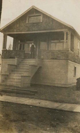
Ernest Pitman family home
https://search.heritageburnaby.ca/link/archivedescription35063
- Repository
- City of Burnaby Archives
- Date
- July 1913
- Collection/Fonds
- Burnaby Historical Society fonds
- Description Level
- Item
- Physical Description
- 1 photograph : b&w ; 10.2 x 6.3 cm
- Scope and Content
- Photograph of Mr and Mrs. Ernest Pitman's house on Cassie Avenue. A man is standing at the top of the porch stairs. Note the board sidewalk in front of the house. An annotation on the back of the photograph reads; "July 1913 / Cassie Ave / Home of Mr. & Mrs. Ernest Pitman."
- Repository
- City of Burnaby Archives
- Date
- July 1913
- Collection/Fonds
- Burnaby Historical Society fonds
- Subseries
- Pitman family subseries
- Physical Description
- 1 photograph : b&w ; 10.2 x 6.3 cm
- Description Level
- Item
- Record No.
- 186-007
- Access Restriction
- No restrictions
- Reproduction Restriction
- No known restrictions
- Accession Number
- BHS1986-35
- Scope and Content
- Photograph of Mr and Mrs. Ernest Pitman's house on Cassie Avenue. A man is standing at the top of the porch stairs. Note the board sidewalk in front of the house. An annotation on the back of the photograph reads; "July 1913 / Cassie Ave / Home of Mr. & Mrs. Ernest Pitman."
- Media Type
- Photograph
- Notes
- Title based on contents of photograph
- Geographic Access
- Cassie Avenue
- Historic Neighbourhood
- Central Park (Historic Neighbourhood)
- Planning Study Area
- Maywood Area
Images


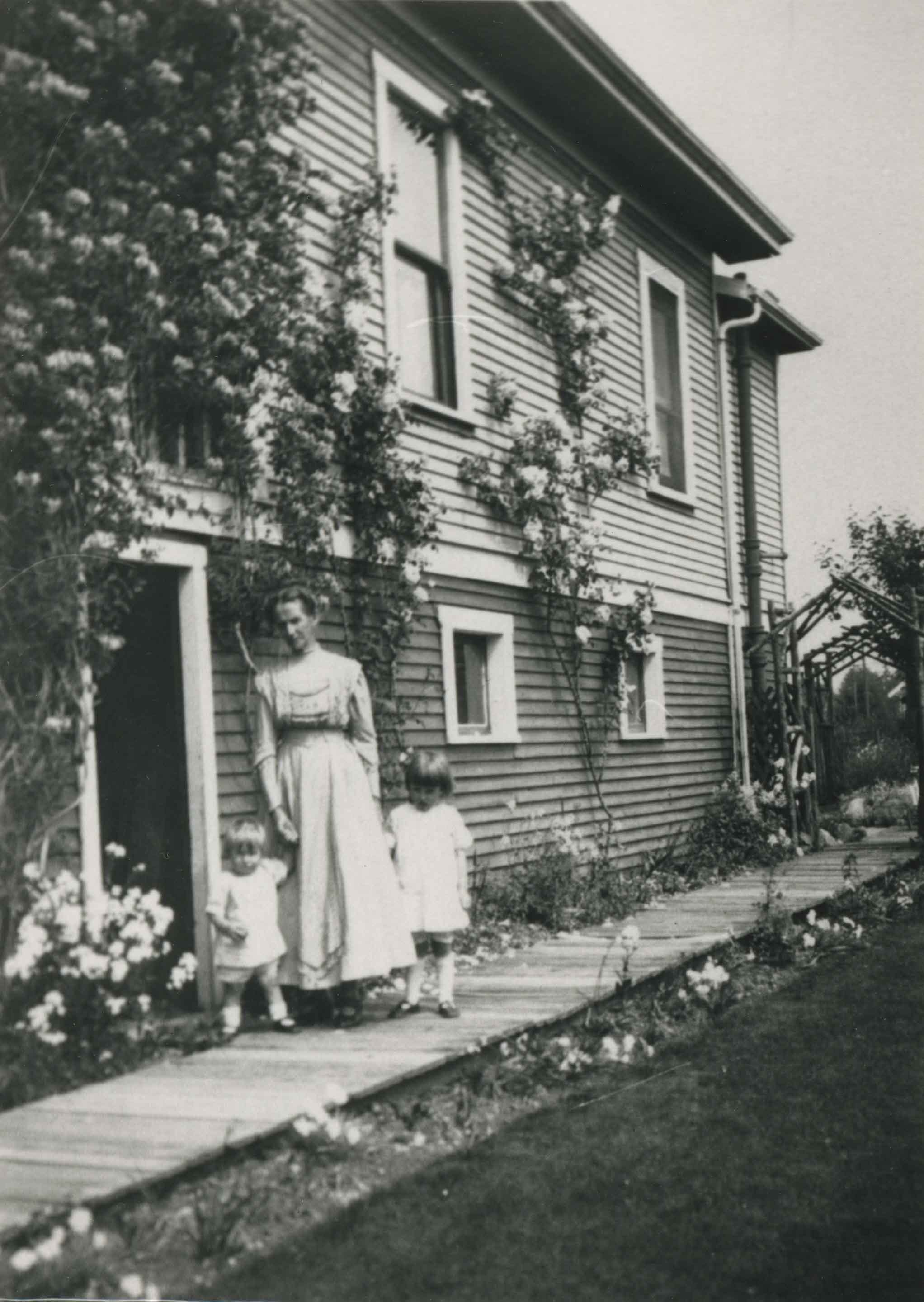
Hopper family
https://search.heritageburnaby.ca/link/archivedescription35081
- Repository
- City of Burnaby Archives
- Date
- 1912 (date of original), copied 1986
- Collection/Fonds
- Burnaby Historical Society fonds
- Description Level
- Item
- Physical Description
- 1 photograph : b&w ; 12.5 x 8.8 cm print
- Scope and Content
- Photograph of Mrs. Hopper and her grandchildren, Betty and Lois Atkinson, in the sideyard of a house on Kathleen Avenue. They are standing on a board sidewalk, and the flowers surrounding the house are in bloom.
- Repository
- City of Burnaby Archives
- Date
- 1912 (date of original), copied 1986
- Collection/Fonds
- Burnaby Historical Society fonds
- Subseries
- Davies family subseries
- Physical Description
- 1 photograph : b&w ; 12.5 x 8.8 cm print
- Description Level
- Item
- Record No.
- 190-001
- Access Restriction
- No restrictions
- Reproduction Restriction
- No known restrictions
- Accession Number
- BHS1986-41
- Scope and Content
- Photograph of Mrs. Hopper and her grandchildren, Betty and Lois Atkinson, in the sideyard of a house on Kathleen Avenue. They are standing on a board sidewalk, and the flowers surrounding the house are in bloom.
- Media Type
- Photograph
- Notes
- Title based on contents of photograph
- Geographic Access
- Kathleen Avenue
- Historic Neighbourhood
- Central Park (Historic Neighbourhood)
- Planning Study Area
- Maywood Area
Images
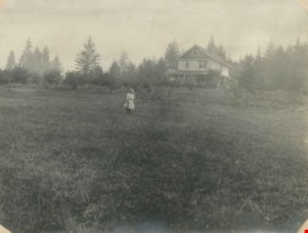
Kitty in front of Broadview
https://search.heritageburnaby.ca/link/archivedescription39556
- Repository
- City of Burnaby Archives
- Date
- 1910
- Collection/Fonds
- Peers Family and Hill Family fonds
- Description Level
- Item
- Physical Description
- 1 photograph : b&w ; 7.6 x 10.2 cm on page 21.5 x 28 cm (pasted in album)
- Scope and Content
- Photograph of Kitty Hill standing in the field in front of her family home, known as Broadview on Buckingham Avenue. This was the second Hill family home in the Burnaby Lake area and it was built around 1907. The first Hill home, Brookfield was on Deer Lake Avenue.
- Repository
- City of Burnaby Archives
- Date
- 1910
- Collection/Fonds
- Peers Family and Hill Family fonds
- Physical Description
- 1 photograph : b&w ; 7.6 x 10.2 cm on page 21.5 x 28 cm (pasted in album)
- Description Level
- Item
- Record No.
- 477-875
- Access Restriction
- No restrictions
- Reproduction Restriction
- No known restrictions
- Accession Number
- 2007-12
- Scope and Content
- Photograph of Kitty Hill standing in the field in front of her family home, known as Broadview on Buckingham Avenue. This was the second Hill family home in the Burnaby Lake area and it was built around 1907. The first Hill home, Brookfield was on Deer Lake Avenue.
- Media Type
- Photograph
- Notes
- Title based on contents of photograph
- Geographic Access
- Buckingham Avenue
- Street Address
- 5730 Buckingham Avenue
- Historic Neighbourhood
- Burnaby Lake (Historic Neighbourhood)
- Planning Study Area
- Morley-Buckingham Area
Images
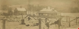
Rowe Ranch
https://search.heritageburnaby.ca/link/archivedescription36022
- Repository
- City of Burnaby Archives
- Date
- 1911
- Collection/Fonds
- Burnaby Historical Society fonds
- Description Level
- Item
- Physical Description
- 1 photograph : sepia ; 5 x 14 cm
- Scope and Content
- Photograph of Rowe Ranch, on Burnaby Lake, at the foot of Burris Street. The lake is covered in snow and ice.
- Repository
- City of Burnaby Archives
- Date
- 1911
- Collection/Fonds
- Burnaby Historical Society fonds
- Subseries
- Patterson family subseries
- Physical Description
- 1 photograph : sepia ; 5 x 14 cm
- Description Level
- Item
- Record No.
- 213-004
- Access Restriction
- No restrictions
- Reproduction Restriction
- No known restrictions
- Accession Number
- BHS1988-13
- Scope and Content
- Photograph of Rowe Ranch, on Burnaby Lake, at the foot of Burris Street. The lake is covered in snow and ice.
- Subjects
- Geographic Features - Lakes and Ponds
- Natural Phenomena - Snow
- Buildings - Residential - Houses
- Media Type
- Photograph
- Notes
- Title based on contents of photograph
- Handwritten note on verso of photograph reads: "Bruce and Bill found a deer frozen in Burnaby lake in the ice".
- Geographic Access
- Burnaby Lake
- Burris Street
- Historic Neighbourhood
- Burnaby Lake (Historic Neighbourhood)
- Planning Study Area
- Burnaby Lake Area
Images
![Spraggon family home, [between 1912 and 1915] (date of original), copied 1991 thumbnail](/media/hpo/_Data/_Archives_Images/_Unrestricted/370/370-774.jpg?width=280)
Spraggon family home
https://search.heritageburnaby.ca/link/archivedescription38187
- Repository
- City of Burnaby Archives
- Date
- [between 1912 and 1915] (date of original), copied 1991
- Collection/Fonds
- Burnaby Historical Society fonds
- Description Level
- Item
- Physical Description
- 1 photograph : b&w ; 4.2 x 3.2 cm print on contact sheet 20.6 x 26.5 cm
- Scope and Content
- Photograph of the Spraggon family home at 3900 Union Street (formerly named Barnard Street). The back of the house and the garden are shown. There is a man digging in garden, possibley Mr. Spraggon.
- Repository
- City of Burnaby Archives
- Date
- [between 1912 and 1915] (date of original), copied 1991
- Collection/Fonds
- Burnaby Historical Society fonds
- Subseries
- Burnaby Image Bank subseries
- Physical Description
- 1 photograph : b&w ; 4.2 x 3.2 cm print on contact sheet 20.6 x 26.5 cm
- Description Level
- Item
- Record No.
- 370-774
- Access Restriction
- No restrictions
- Reproduction Restriction
- No known restrictions
- Accession Number
- BHS1999-03
- Scope and Content
- Photograph of the Spraggon family home at 3900 Union Street (formerly named Barnard Street). The back of the house and the garden are shown. There is a man digging in garden, possibley Mr. Spraggon.
- Media Type
- Photograph
- Notes
- Title based on contents of photograph
- 1 b&w copy negative accompanying
- Negative has a pink cast
- Geographic Access
- Union Street
- Street Address
- 3900 Union Street
- Historic Neighbourhood
- Vancouver Heights (Historic Neighbourhood)
- Planning Study Area
- Willingdon Heights Area
Images
![Spraggon family home, [between 1912 and 1915] (date of original), copied 1991 thumbnail](/media/hpo/_Data/_Archives_Images/_Unrestricted/370/370-774.jpg)
![Walker family home, [1912] (date of original), copied 1986 thumbnail](/media/hpo/_Data/_Archives_Images/_Unrestricted/204/204-229.jpg?width=280)
Walker family home
https://search.heritageburnaby.ca/link/archivedescription35372
- Repository
- City of Burnaby Archives
- Date
- [1912] (date of original), copied 1986
- Collection/Fonds
- Burnaby Historical Society fonds
- Description Level
- Item
- Physical Description
- 1 photograph : b&w ; 12.7 x 17.8 cm print
- Scope and Content
- Photograph of the William George Walker house at Edmonds and Kingsway, 7328 Edmonds Street, built in 1909. The houses in the background are on Linden Avenue.
- Repository
- City of Burnaby Archives
- Date
- [1912] (date of original), copied 1986
- Collection/Fonds
- Burnaby Historical Society fonds
- Subseries
- Pioneer Tales subseries
- Physical Description
- 1 photograph : b&w ; 12.7 x 17.8 cm print
- Description Level
- Item
- Record No.
- 204-229
- Access Restriction
- No restrictions
- Reproduction Restriction
- No known restrictions
- Accession Number
- BHS1988-03
- Scope and Content
- Photograph of the William George Walker house at Edmonds and Kingsway, 7328 Edmonds Street, built in 1909. The houses in the background are on Linden Avenue.
- Media Type
- Photograph
- Notes
- Title based on contents of photograph
- Geographic Access
- Edmonds Street
- Linden Avenue
- Street Address
- 7328 Edmonds Street
- Historic Neighbourhood
- Edmonds (Historic Neighbourhood)
- Planning Study Area
- Richmond Park Area
Images
![Walker family home, [1912] (date of original), copied 1986 thumbnail](/media/hpo/_Data/_Archives_Images/_Unrestricted/204/204-229.jpg)

Boundary Road and Park Avenue station
https://search.heritageburnaby.ca/link/archivedescription36670
- Repository
- City of Burnaby Archives
- Date
- 1912 (date of original), copied 1992
- Collection/Fonds
- Burnaby Historical Society fonds
- Description Level
- Item
- Physical Description
- 1 photograph : b&w ; 10.1 x 14.9 cm print
- Scope and Content
- Photograph of Boundary Road, Park Avenue Interurban station, and the surrounding area, looking north from Kingsway. The Coburn house, built in 1906, is at the top of the hill on the right, current address 5170 Boundary Road.
- Repository
- City of Burnaby Archives
- Date
- 1912 (date of original), copied 1992
- Collection/Fonds
- Burnaby Historical Society fonds
- Subseries
- Burnaby Centennial Anthology subseries
- Physical Description
- 1 photograph : b&w ; 10.1 x 14.9 cm print
- Description Level
- Item
- Record No.
- 315-025
- Access Restriction
- No restrictions
- Reproduction Restriction
- No known restrictions
- Accession Number
- BHS1994-04
- Scope and Content
- Photograph of Boundary Road, Park Avenue Interurban station, and the surrounding area, looking north from Kingsway. The Coburn house, built in 1906, is at the top of the hill on the right, current address 5170 Boundary Road.
- Media Type
- Photograph
- Notes
- Title based on contents of photograph
- Annotation at bottom of photograph reads; "Boundary Rd and Park Ave Station"
- Geographic Access
- Boundary Road
- Kingsway
- Historic Neighbourhood
- Central Park (Historic Neighbourhood)
- Planning Study Area
- Garden Village Area
Images

![Great Northern Railway crossing, [1914] thumbnail](/media/hpo/_Data/_BVM_Images/1971/197200110009.jpg?width=280)
Great Northern Railway crossing
https://search.heritageburnaby.ca/link/museumdescription3095
- Repository
- Burnaby Village Museum
- Date
- [1914]
- Collection/Fonds
- Burnaby Village Museum Photograph collection
- Description Level
- Item
- Physical Description
- 1 photograph : b&w glass negative ; 20.2 x 15.8 cm
- Scope and Content
- Photograph of the Great Northern Railway crossing meeting a road that appears to have run parellel to the railway on a bluff. On the left side of the photograph is a small hut beside a sign that reads, "Railway Crossing." Two unidentified men are standing outside of the hut. An earlier catalogue re…
- Repository
- Burnaby Village Museum
- Collection/Fonds
- Burnaby Village Museum Photograph collection
- Description Level
- Item
- Physical Description
- 1 photograph : b&w glass negative ; 20.2 x 15.8 cm
- Material Details
- Inscribed on negative, and printed backwards on contact print, l.r. "G.N.RAILWAY......../SHEWI [rest of the word illegible] INTERSECTION). CROSSING.../ [illegible word] ROAD. LOOKING NORTH"
- Scope and Content
- Photograph of the Great Northern Railway crossing meeting a road that appears to have run parellel to the railway on a bluff. On the left side of the photograph is a small hut beside a sign that reads, "Railway Crossing." Two unidentified men are standing outside of the hut. An earlier catalogue record from 1988 notes that the crossing street is North Road, and the photograph was taken looking northwest into Burnaby. Inscribed on negative, lower right: "G.N. Railway /Shewi [rest of the word illegible] Intersection) Crossing / [illegible word] Road. Looking North."
- Names
- Great Northern Railway
- Geographic Access
- North Road
- Accession Code
- HV972.11.9
- Access Restriction
- No restrictions
- Reproduction Restriction
- No known restrictions
- Date
- [1914]
- Media Type
- Photograph
- Planning Study Area
- Cariboo-Armstrong Area
- Scan Resolution
- 300
- Scan Date
- 14/8/2006
- Scale
- 100
- Notes
- Title based on contents of photograph
- 1 b&w contact print accompanying negative
Images
![Great Northern Railway crossing, [1914] thumbnail](/media/hpo/_Data/_BVM_Images/1971/197200110009.jpg)
![Railway embankment, [1914] thumbnail](/media/hpo/_Data/_BVM_Images/1971/197200110002.jpg?width=280)
Railway embankment
https://search.heritageburnaby.ca/link/museumdescription3089
- Repository
- Burnaby Village Museum
- Date
- [1914]
- Collection/Fonds
- Burnaby Village Museum Photograph collection
- Description Level
- Item
- Physical Description
- 1 photograph : b&w glass negative ; 14.8 x 20.1 cm
- Scope and Content
- Photograph of a railway embankment. In the foreground is the railway, and in the midground a steep bluff, on top of which an unidentified man in a suit and a bowler hat is standing. There appears to be a road lined with electric posts close to where the man stands. An earlier catalogue record from…
- Repository
- Burnaby Village Museum
- Collection/Fonds
- Burnaby Village Museum Photograph collection
- Description Level
- Item
- Physical Description
- 1 photograph : b&w glass negative ; 14.8 x 20.1 cm
- Scope and Content
- Photograph of a railway embankment. In the foreground is the railway, and in the midground a steep bluff, on top of which an unidentified man in a suit and a bowler hat is standing. There appears to be a road lined with electric posts close to where the man stands. An earlier catalogue record from 1988 notes that this is the view of the Great Northern Railway just north of Brunette Creek on North Road. Also, it notes that the road running by the man is North Road.
- Names
- Great Northern Railway
- Geographic Access
- North Road
- Accession Code
- HV972.11.2
- Access Restriction
- No restrictions
- Reproduction Restriction
- No known restrictions
- Date
- [1914]
- Media Type
- Photograph
- Planning Study Area
- Cariboo-Armstrong Area
- Related Material
- for another view of the same railway embankment, see HV972.11.4
- Scan Resolution
- 300
- Scan Date
- 14/8/2006
- Scale
- 100
- Notes
- Title based on contents of photograph
- 1 b&w contact print accompanying negative
Images
![Railway embankment, [1914] thumbnail](/media/hpo/_Data/_BVM_Images/1971/197200110002.jpg)

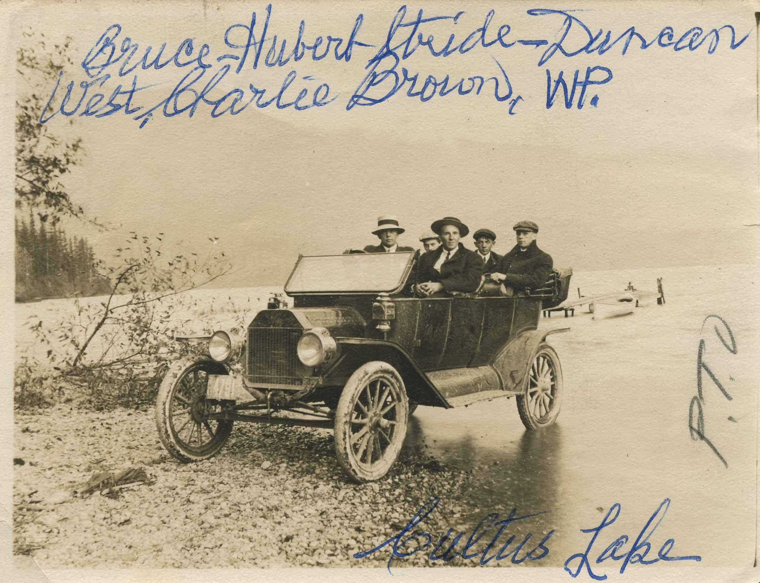
Cultus Lake
https://search.heritageburnaby.ca/link/archivedescription36028
- Repository
- City of Burnaby Archives
- Date
- 1913
- Collection/Fonds
- Burnaby Historical Society fonds
- Description Level
- Item
- Physical Description
- 1 photograph : sepia ; 7.5 x 10 cm
- Scope and Content
- Photograph of a Model T Ford parked on the beach at Cultus Lake with five men all wearing hats sitting inside it. Writting on the front of the photograph (in blue ink) reads: "Bruce, Hubert Stride, Duncan West, Charlie Brown, W.P. Cultus Lake", and in pencil: "P.T.O."
- Repository
- City of Burnaby Archives
- Date
- 1913
- Collection/Fonds
- Burnaby Historical Society fonds
- Subseries
- Patterson family subseries
- Physical Description
- 1 photograph : sepia ; 7.5 x 10 cm
- Description Level
- Item
- Record No.
- 213-010
- Access Restriction
- No restrictions
- Reproduction Restriction
- No known restrictions
- Accession Number
- BHS1988-13
- Scope and Content
- Photograph of a Model T Ford parked on the beach at Cultus Lake with five men all wearing hats sitting inside it. Writting on the front of the photograph (in blue ink) reads: "Bruce, Hubert Stride, Duncan West, Charlie Brown, W.P. Cultus Lake", and in pencil: "P.T.O."
- Media Type
- Photograph
- Notes
- Title based on contents of photograph
- Note in blue ink on verso of photograph reads: "Rec'd 29/6 1946 from Margaret Bacchus - See Individuals folder -"
Images

Driving over a log bridge
https://search.heritageburnaby.ca/link/archivedescription36026
- Repository
- City of Burnaby Archives
- Date
- 1912
- Collection/Fonds
- Burnaby Historical Society fonds
- Description Level
- Item
- Physical Description
- 1 photograph : sepia ; 7.7 x 10.3 cm
- Scope and Content
- Photograph of Patterson's car driving over a log bridge, believed to be the Cariboo Road Bridge over the Brunette river. A man in a trilby hat is in the driver's side of the car, with his hand on the steering wheel, facing the camera.
- Repository
- City of Burnaby Archives
- Date
- 1912
- Collection/Fonds
- Burnaby Historical Society fonds
- Subseries
- Patterson family subseries
- Physical Description
- 1 photograph : sepia ; 7.7 x 10.3 cm
- Description Level
- Item
- Record No.
- 213-008
- Access Restriction
- No restrictions
- Reproduction Restriction
- No known restrictions
- Accession Number
- BHS1988-13
- Scope and Content
- Photograph of Patterson's car driving over a log bridge, believed to be the Cariboo Road Bridge over the Brunette river. A man in a trilby hat is in the driver's side of the car, with his hand on the steering wheel, facing the camera.
- Media Type
- Photograph
- Notes
- Title based on contents of photograph
- Geographic Access
- Cariboo Road
- Planning Study Area
- Burnaby Lake Area
Images
