More like 'Earthquake preparedness at Nelson Avenue School'
Narrow Results By
Decade
- 2020s 132
- 2010s 84
- 2000s 1020
- 1990s 568
- 1980s 500
- 1970s 1064
- 1960s 379
- 1950s 587
- 1940s 565
- 1930s 483
- 1920s 508
- 1910s
- 1900s 211
- 1890s 35
- 1880s 52
- 1870s 6
- 1860s 3
- 1850s 1
- 1840s 1
- 1830s 2
- 1820s 1
- 1810s 1
- 1800s 1
- 1790s 1
- 1780s 1
- 1770s 1
- 1760s 1
- 1750s 1
- 1740s 1
- 1730s 1
- 1720s 1
- 1710s 1
- 1700s 1
- 1690s 1
- 1680s 1
- 1670s 1
- 1660s 1
- 1650s 1
- 1640s 1
- 1630s 1
- 1620s 1
- 1610s 1
- 1600s 1
Creator
- Barrowclough, G.A. 1
- Barrowclough, George Alfred 1
- BC Photo Card Company 1
- Brown, W. 1
- Burnaby Village Museum 5
- Burnett and McGugan B.C. Land Surveyors, New Westminster 5
- Burnett, Geoffrey K. 3
- Burnett & McGugan, Engineers and Surveyors 22
- Canadian Photo Company 12
- Challoner-Courtenay, E.J. 2
- Damer, Eric 1
- Dean, H.M. 13
![Monuments for school sites, [1915] thumbnail](/media/hpo/_Data/_BVM_Cartographic_Material/2003/2003_0083_0010_001.jpg?width=280)
Monuments for school sites
https://search.heritageburnaby.ca/link/museumdescription11915
- Repository
- Burnaby Village Museum
- Date
- [1915]
- Collection/Fonds
- Ronald G. Scobbie collection
- Description Level
- Item
- Physical Description
- 1 architectural drawing : pencil on paper ; 27.5 x 21 cm
- Scope and Content
- Item consists of a drawing titled "Plans of Proposed concrete monuments for corners of / school sites for Burnaby School Board".
- Repository
- Burnaby Village Museum
- Collection/Fonds
- Ronald G. Scobbie collection
- Description Level
- Item
- Physical Description
- 1 architectural drawing : pencil on paper ; 27.5 x 21 cm
- Scope and Content
- Item consists of a drawing titled "Plans of Proposed concrete monuments for corners of / school sites for Burnaby School Board".
- Creator
- McGugan, Donald Johnston
- Subjects
- Buildings - Schools
- Accession Code
- BV003.83.10
- Access Restriction
- No restrictions
- Reproduction Restriction
- No known restrictions
- Date
- [1915]
- Media Type
- Architectural Drawing
- Scan Resolution
- 600
- Scale
- 100
- Notes
- Title based on contents of drawing
- Red crayon marking on plan reads: "001819"
Images
![Monuments for school sites, [1915] thumbnail](/media/hpo/_Data/_BVM_Cartographic_Material/2003/2003_0083_0010_001.jpg)
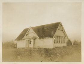
![Nelson Avenue School, [between 1911 and 1919] thumbnail](/media/hpo/_Data/_Archives_Images/_Unrestricted/316/325-041.jpg?width=280)
Nelson Avenue School
https://search.heritageburnaby.ca/link/archivedescription37169
- Repository
- City of Burnaby Archives
- Date
- [between 1911 and 1919]
- Collection/Fonds
- Burnaby Historical Society fonds
- Description Level
- Item
- Physical Description
- 1 photograph : b&w ; 8 x 12.5 cm print
- Scope and Content
- Photograph of Nelson Avenue School, which was established in 1912 to serve the Alta Vista district of Burnaby.
- Repository
- City of Burnaby Archives
- Date
- [between 1911 and 1919]
- Collection/Fonds
- Burnaby Historical Society fonds
- Subseries
- Disney family subseries
- Physical Description
- 1 photograph : b&w ; 8 x 12.5 cm print
- Description Level
- Item
- Record No.
- 325-041
- Access Restriction
- No restrictions
- Reproduction Restriction
- No known restrictions
- Accession Number
- BHS1996-04
- Scope and Content
- Photograph of Nelson Avenue School, which was established in 1912 to serve the Alta Vista district of Burnaby.
- Subjects
- Buildings - Schools
- Names
- Nelson Avenue School
- Media Type
- Photograph
- Photographer
- Disney, John Harold "Jack"
- Notes
- Title based on contents of photograph
- Geographic Access
- Irmin Street
- Street Address
- 4850 Irmin Street
- Historic Neighbourhood
- Alta-Vista (Historic Neighbourhood)
- Planning Study Area
- Sussex-Nelson Area
Images
![Nelson Avenue School, [between 1911 and 1919] thumbnail](/media/hpo/_Data/_Archives_Images/_Unrestricted/316/325-041.jpg)

Nelson Avenue School site
https://search.heritageburnaby.ca/link/museumdescription11135
- Repository
- Burnaby Village Museum
- Date
- April 12, 1915
- Collection/Fonds
- Ronald G. Scobbie collection
- Description Level
- Item
- Physical Description
- 1 survey plan : blueprint on paper ; 56 x 54 cm
- Scope and Content
- Survey plan of "Nelson Avenue School Site / Burnaby Municipality" "Being the south half of Block 19, except therefrom the north 33 feet, of Lot 99, Gp. 1. New Westminster District".
- Repository
- Burnaby Village Museum
- Collection/Fonds
- Ronald G. Scobbie collection
- Description Level
- Item
- Physical Description
- 1 survey plan : blueprint on paper ; 56 x 54 cm
- Material Details
- Scale 40 feet = 1 inch
- Scope and Content
- Survey plan of "Nelson Avenue School Site / Burnaby Municipality" "Being the south half of Block 19, except therefrom the north 33 feet, of Lot 99, Gp. 1. New Westminster District".
- Creator
- McGugan, Donald Johnston
- Subjects
- Buildings - Schools
- Names
- Nelson Avenue School
- Responsibility
- Burnett & McGugan, Engineers and Surveyors
- Geographic Access
- Irmin Street
- Street Address
- 4850 Irmin Street
- Accession Code
- BV003.83.14
- Access Restriction
- No restrictions
- Reproduction Restriction
- No known restrictions
- Date
- April 12, 1915
- Media Type
- Cartographic Material
- Historic Neighbourhood
- Alta Vista (Historic Neighbourhood)
- Planning Study Area
- Sussex-Nelson Area
- Scan Resolution
- 440
- Scan Date
- 22-Dec-2020
- Scale
- 100
- Notes
- Title based on contents of plan
- Note in black ink on verso of plan reads: "1745"
- Oath on plan reads: "I, D.G. McGugan..." "...and did person- ally superintend the survey..." "...completed on the 5th day of March 1915"; signed by D.J. McGugan, notarized by "R.E. Chapman", sworn "...12th day of April 1915" "Burnett and McGugan" "B.C. Land Surveyors Etc. New Westminster, B.C.."
Images

![Path to Hamilton Road School, [between 1911 and 1919] thumbnail](/media/hpo/_Data/_Archives_Images/_Unrestricted/316/325-042.jpg?width=280)
Path to Hamilton Road School
https://search.heritageburnaby.ca/link/archivedescription37170
- Repository
- City of Burnaby Archives
- Date
- [between 1911 and 1919]
- Collection/Fonds
- Burnaby Historical Society fonds
- Description Level
- Item
- Physical Description
- 1 photograph : b&w ; 8.5 x 12.5 cm print
- Scope and Content
- Photograph of Hamilton Road School taken from a distance, with a visible path leading up to the school.
- Repository
- City of Burnaby Archives
- Date
- [between 1911 and 1919]
- Collection/Fonds
- Burnaby Historical Society fonds
- Subseries
- Disney family subseries
- Physical Description
- 1 photograph : b&w ; 8.5 x 12.5 cm print
- Description Level
- Item
- Record No.
- 325-042
- Access Restriction
- No restrictions
- Reproduction Restriction
- No known restrictions
- Accession Number
- BHS1996-04
- Scope and Content
- Photograph of Hamilton Road School taken from a distance, with a visible path leading up to the school.
- Subjects
- Buildings - Schools
- Names
- Hamilton Road School
- Media Type
- Photograph
- Photographer
- Disney, John Harold "Jack"
- Notes
- Title based on contents of photograph
- Geographic Access
- Lyndhurst Street
- Historic Neighbourhood
- Burquitlam (Historic Neighbourhood)
- Planning Study Area
- Sperling-Broadway Area
Images
![Path to Hamilton Road School, [between 1911 and 1919] thumbnail](/media/hpo/_Data/_Archives_Images/_Unrestricted/316/325-042.jpg)
![Riverway East School, [between 1911 and 1919] thumbnail](/media/hpo/_Data/_Archives_Images/_Unrestricted/316/325-023.jpg?width=280)
Riverway East School
https://search.heritageburnaby.ca/link/archivedescription37151
- Repository
- City of Burnaby Archives
- Date
- [between 1911 and 1919]
- Collection/Fonds
- Burnaby Historical Society fonds
- Description Level
- Item
- Physical Description
- 1 photograph : b&w ; 8 x 12.5 cm print
- Scope and Content
- Photograph of Riverway East (renamed Dundonald) School taken from River Road (now Marine Drive). A large pile of cordwood is visible alongside the school.
- Repository
- City of Burnaby Archives
- Date
- [between 1911 and 1919]
- Collection/Fonds
- Burnaby Historical Society fonds
- Subseries
- Disney family subseries
- Physical Description
- 1 photograph : b&w ; 8 x 12.5 cm print
- Description Level
- Item
- Record No.
- 325-023
- Access Restriction
- No restrictions
- Reproduction Restriction
- No known restrictions
- Accession Number
- BHS1996-04
- Scope and Content
- Photograph of Riverway East (renamed Dundonald) School taken from River Road (now Marine Drive). A large pile of cordwood is visible alongside the school.
- Subjects
- Buildings - Schools
- Names
- Riverway East School
- Media Type
- Photograph
- Photographer
- Disney, John Harold "Jack"
- Notes
- Title based on contents of photograph
- Geographic Access
- Gilley Avenue
- Marine Drive
- Street Address
- 5787 Marine Drive
- Historic Neighbourhood
- Alta-Vista (Historic Neighbourhood)
- Planning Study Area
- Clinton-Glenwood Area
Images
![Riverway East School, [between 1911 and 1919] thumbnail](/media/hpo/_Data/_Archives_Images/_Unrestricted/316/325-023.jpg)

Riverway School site
https://search.heritageburnaby.ca/link/museumdescription11134
- Repository
- Burnaby Village Museum
- Date
- April 16, 1915
- Collection/Fonds
- Ronald G. Scobbie collection
- Description Level
- Item
- Physical Description
- 1 survey plan : blueprint on paper ; 56 x 54 cm
- Scope and Content
- Survey plan of "Riverway School Site / Burnaby Municipality" "Being a 1 acre portion of Lot 159 Group 1, and Lots 30 & 31 of subd. of Bks. 1, 1a, 2, 3, 4 & 5 of Lot 159, Group 1, New Westminster District".
- Repository
- Burnaby Village Museum
- Collection/Fonds
- Ronald G. Scobbie collection
- Description Level
- Item
- Physical Description
- 1 survey plan : blueprint on paper ; 56 x 54 cm
- Material Details
- Scale 40 feet = 1 inch
- Scope and Content
- Survey plan of "Riverway School Site / Burnaby Municipality" "Being a 1 acre portion of Lot 159 Group 1, and Lots 30 & 31 of subd. of Bks. 1, 1a, 2, 3, 4 & 5 of Lot 159, Group 1, New Westminster District".
- Creator
- Geoffrey K. Burnett
- Subjects
- Buildings - Schools
- Names
- Riverway East School
- Responsibility
- Burnett and McGugan B.C. Land Surveyors, New Westminster
- Geographic Access
- Gilley Avenue
- Marine Drive
- Street Address
- 5787 Marine Drive
- Accession Code
- BV003.83.13
- Access Restriction
- No restrictions
- Reproduction Restriction
- No known restrictions
- Date
- April 16, 1915
- Media Type
- Cartographic Material
- Historic Neighbourhood
- Alta Vista (Historic Neighbourhood)
- Planning Study Area
- Clinton-Glenwood Area
- Scan Resolution
- 440
- Scan Date
- 22-Dec-2020
- Scale
- 100
- Notes
- Title based on contents of plan
- Note in black ink on verso of plan reads: "1744" / "Riverway School"
- Oath on plan reads: "I, Geoffrey K. Burnett...and did personally superintend the survey..." "...completed on the 16th day of April 1915"; signed by Geoffrey K. Burnett and notarized by "K.A. Eastman", sworn "...19th day of April 1915"
Zoomable Images

![Schou Street School, [between 1913 and 1919] thumbnail](/media/hpo/_Data/_Archives_Images/_Unrestricted/316/325-025.jpg?width=280)
Schou Street School
https://search.heritageburnaby.ca/link/archivedescription37153
- Repository
- City of Burnaby Archives
- Date
- [between 1913 and 1919]
- Collection/Fonds
- Burnaby Historical Society fonds
- Description Level
- Item
- Physical Description
- 1 photograph : b&w ; 8 x 12.5 cm print
- Scope and Content
- Photograph of the Schou Street School and surrounding area.
- Repository
- City of Burnaby Archives
- Date
- [between 1913 and 1919]
- Collection/Fonds
- Burnaby Historical Society fonds
- Subseries
- Disney family subseries
- Physical Description
- 1 photograph : b&w ; 8 x 12.5 cm print
- Description Level
- Item
- Record No.
- 325-025
- Access Restriction
- No restrictions
- Reproduction Restriction
- No known restrictions
- Accession Number
- BHS1996-04
- Scope and Content
- Photograph of the Schou Street School and surrounding area.
- Subjects
- Buildings - Schools
- Names
- Schou Street School
- Media Type
- Photograph
- Photographer
- Disney, John Harold "Jack"
- Notes
- Title based on contents of photograph
- Geographic Access
- Grandview Highway
- Canada Way
- Street Address
- 4054 Norfolk Street
- Historic Neighbourhood
- Broadview (Historic Neighbourhood)
- Planning Study Area
- Cascade-Schou Area
Images
![Schou Street School, [between 1913 and 1919] thumbnail](/media/hpo/_Data/_Archives_Images/_Unrestricted/316/325-025.jpg)
![Schou Street School side entrance, [between 1913 and 1919] thumbnail](/media/hpo/_Data/_Archives_Images/_Unrestricted/316/325-026.jpg?width=280)
Schou Street School side entrance
https://search.heritageburnaby.ca/link/archivedescription37154
- Repository
- City of Burnaby Archives
- Date
- [between 1913 and 1919]
- Collection/Fonds
- Burnaby Historical Society fonds
- Description Level
- Item
- Physical Description
- 1 photograph : b&w ; 8 x 12.5 cm print
- Scope and Content
- Photograph of the side entrance to the Schou Street School, and its surrounding school yard.
- Repository
- City of Burnaby Archives
- Date
- [between 1913 and 1919]
- Collection/Fonds
- Burnaby Historical Society fonds
- Subseries
- Disney family subseries
- Physical Description
- 1 photograph : b&w ; 8 x 12.5 cm print
- Description Level
- Item
- Record No.
- 325-026
- Access Restriction
- No restrictions
- Reproduction Restriction
- No known restrictions
- Accession Number
- BHS1996-04
- Scope and Content
- Photograph of the side entrance to the Schou Street School, and its surrounding school yard.
- Subjects
- Buildings - Schools
- Names
- Schou Street School
- Media Type
- Photograph
- Photographer
- Disney, John Harold "Jack"
- Notes
- Title based on contents of photograph
- Geographic Access
- Grandview Highway
- Canada Way
- Street Address
- 4054 Norfolk Street
- Historic Neighbourhood
- Broadview (Historic Neighbourhood)
- Planning Study Area
- Cascade-Schou Area
Images
![Schou Street School side entrance, [between 1913 and 1919] thumbnail](/media/hpo/_Data/_Archives_Images/_Unrestricted/316/325-026.jpg)
![Schou Street School side entrance, [between 1913 and 1919] thumbnail](/media/hpo/_Data/_Archives_Images/_Unrestricted/316/325-027.jpg?width=280)
Schou Street School side entrance
https://search.heritageburnaby.ca/link/archivedescription37155
- Repository
- City of Burnaby Archives
- Date
- [between 1913 and 1919]
- Collection/Fonds
- Burnaby Historical Society fonds
- Description Level
- Item
- Physical Description
- 1 photograph : b&w ; 7.5 x 12.5 cm print
- Scope and Content
- Photograph of the side entrance to the Schou Street School, and its surrounding school yard.
- Repository
- City of Burnaby Archives
- Date
- [between 1913 and 1919]
- Collection/Fonds
- Burnaby Historical Society fonds
- Subseries
- Disney family subseries
- Physical Description
- 1 photograph : b&w ; 7.5 x 12.5 cm print
- Description Level
- Item
- Record No.
- 325-027
- Access Restriction
- No restrictions
- Reproduction Restriction
- No known restrictions
- Accession Number
- BHS1996-04
- Scope and Content
- Photograph of the side entrance to the Schou Street School, and its surrounding school yard.
- Subjects
- Buildings - Schools
- Names
- Schou Street School
- Media Type
- Photograph
- Photographer
- Disney, John Harold "Jack"
- Notes
- Title based on contents of photograph
- Geographic Access
- Grandview Highway
- Canada Way
- Street Address
- 4054 Norfolk Street
- Historic Neighbourhood
- Broadview (Historic Neighbourhood)
- Planning Study Area
- Cascade-Schou Area
Images
![Schou Street School side entrance, [between 1913 and 1919] thumbnail](/media/hpo/_Data/_Archives_Images/_Unrestricted/316/325-027.jpg)

Schou Street School site
https://search.heritageburnaby.ca/link/museumdescription11138
- Repository
- Burnaby Village Museum
- Date
- April 12, 1915
- Collection/Fonds
- Ronald G. Scobbie collection
- Description Level
- Item
- Physical Description
- 1 survey plan : blueprint on paper ; 56 x 54 cm
- Scope and Content
- Survey plan of "Schou Street School Site / Burnaby Municipality" "Being Lot 1-12 inc. of Block 47, of subd. of Blocks 8-12 and 15-49 inclusive, Lot 69, Group 1" "New Westminster District";
- Repository
- Burnaby Village Museum
- Collection/Fonds
- Ronald G. Scobbie collection
- Description Level
- Item
- Physical Description
- 1 survey plan : blueprint on paper ; 56 x 54 cm
- Material Details
- Scale 40 feet = 1 inch
- Scope and Content
- Survey plan of "Schou Street School Site / Burnaby Municipality" "Being Lot 1-12 inc. of Block 47, of subd. of Blocks 8-12 and 15-49 inclusive, Lot 69, Group 1" "New Westminster District";
- Creator
- Burnett, Geoffrey K.
- Subjects
- Buildings - Schools
- Names
- Schou Street School
- Responsibility
- Burnett & McGugan, Engineers and Surveyors
- Geographic Access
- Canada Way
- Grandview Highway
- Gilmore Avenue
- Street Address
- 4054 Norfolk Street
- Accession Code
- BV003.83.17
- Access Restriction
- No restrictions
- Reproduction Restriction
- No known restrictions
- Date
- April 12, 1915
- Media Type
- Cartographic Material
- Historic Neighbourhood
- Broadview (Historic Neighbourhood)
- Planning Study Area
- Cascade-Schou Area
- Scan Resolution
- 440
- Scan Date
- 22-Dec-2020
- Scale
- 100
- Notes
- Title based on contents of plan
- Oath on plan reads: "I, Geoffrey K. Burnett...did person- ally superintend the survey..." "...completed on the 12th day of April 1915"; signed by Geoffrey K. Burnett, notarized by "S.F. Mark", sworn "..12th day.. April 1915" "Burnett and McGugan" "B.C. Land Surveyors Etc. New Westminster, B.C.
- ."handwritten on back, "1751"
- two school buildings are shown on this blueprint, "Old School Building", "New School Building"
Images

![Second Street School, [between 1913 and 1919] thumbnail](/media/hpo/_Data/_Archives_Images/_Unrestricted/316/325-032.jpg?width=280)
Second Street School
https://search.heritageburnaby.ca/link/archivedescription37160
- Repository
- City of Burnaby Archives
- Date
- [between 1913 and 1919]
- Collection/Fonds
- Burnaby Historical Society fonds
- Description Level
- Item
- Physical Description
- 1 photograph : b&w ; 7.5 x 10 cm print
- Scope and Content
- Photograph of Second Street School taken from a distance.
- Repository
- City of Burnaby Archives
- Date
- [between 1913 and 1919]
- Collection/Fonds
- Burnaby Historical Society fonds
- Subseries
- Disney family subseries
- Physical Description
- 1 photograph : b&w ; 7.5 x 10 cm print
- Description Level
- Item
- Record No.
- 325-032
- Access Restriction
- No restrictions
- Reproduction Restriction
- No known restrictions
- Accession Number
- BHS1996-04
- Scope and Content
- Photograph of Second Street School taken from a distance.
- Subjects
- Buildings - Schools
- Names
- Second Street School
- Media Type
- Photograph
- Photographer
- Disney, John Harold "Jack"
- Notes
- Title based on contents of photograph
- Geographic Access
- 2nd Street
- Street Address
- 7502 2nd Street
- Historic Neighbourhood
- East Burnaby (Historic Neighbourhood)
- Planning Study Area
- Second Street Area
Images
![Second Street School, [between 1913 and 1919] thumbnail](/media/hpo/_Data/_Archives_Images/_Unrestricted/316/325-032.jpg)
![Second Street School, [between 1913 and 1919] thumbnail](/media/hpo/_Data/_Archives_Images/_Unrestricted/316/325-033.jpg?width=280)
Second Street School
https://search.heritageburnaby.ca/link/archivedescription37161
- Repository
- City of Burnaby Archives
- Date
- [between 1913 and 1919]
- Collection/Fonds
- Burnaby Historical Society fonds
- Description Level
- Item
- Physical Description
- 1 photograph : b&w ; 8 x 12.5 cm print
- Scope and Content
- Photograph of Second Street School.
- Repository
- City of Burnaby Archives
- Date
- [between 1913 and 1919]
- Collection/Fonds
- Burnaby Historical Society fonds
- Subseries
- Disney family subseries
- Physical Description
- 1 photograph : b&w ; 8 x 12.5 cm print
- Description Level
- Item
- Record No.
- 325-033
- Access Restriction
- No restrictions
- Reproduction Restriction
- No known restrictions
- Accession Number
- BHS1996-04
- Scope and Content
- Photograph of Second Street School.
- Subjects
- Buildings - Schools
- Names
- Second Street School
- Media Type
- Photograph
- Photographer
- Disney, John Harold "Jack"
- Notes
- Title based on contents of photograph
- Geographic Access
- 2nd Street
- Street Address
- 7502 2nd Street
- Historic Neighbourhood
- East Burnaby (Historic Neighbourhood)
- Planning Study Area
- Second Street Area
Images
![Second Street School, [between 1913 and 1919] thumbnail](/media/hpo/_Data/_Archives_Images/_Unrestricted/316/325-033.jpg)
Second Street School
https://search.heritageburnaby.ca/link/museumdescription1262
- Repository
- Burnaby Village Museum
- Date
- 1913
- Collection/Fonds
- Burnaby Village Museum Photograph collection
- Description Level
- Item
- Physical Description
- 1 photograph : sepia ; 8 x 10.5 cm
- Scope and Content
- Photograph of Second Street School taken from a distance.
- Repository
- Burnaby Village Museum
- Collection/Fonds
- Burnaby Village Museum Photograph collection
- Description Level
- Item
- Physical Description
- 1 photograph : sepia ; 8 x 10.5 cm
- Scope and Content
- Photograph of Second Street School taken from a distance.
- Subjects
- Buildings - Schools
- Names
- Second Street School
- Geographic Access
- 2nd Street
- Street Address
- 7502 2nd Street
- Accession Code
- BV997.21.12
- Access Restriction
- No restrictions
- Date
- 1913
- Media Type
- Photograph
- Historic Neighbourhood
- East Burnaby (Historic Neighbourhood)
- Planning Study Area
- Second Street Area
- Scan Resolution
- 600
- Scan Date
- 01-Jun-09
- Scale
- 100
- Notes
- Title based on contents of photograph
- Note on verso of photograph: "SECOND STREET SCHOOL 1913 / Nina Chapman/ (Atkinson) / 521-0370"
Images


Second Street School site
https://search.heritageburnaby.ca/link/museumdescription11920
- Repository
- Burnaby Village Museum
- Date
- May 29, 1915
- Collection/Fonds
- Ronald G. Scobbie collection
- Description Level
- Item
- Physical Description
- 1 survey plan : blueprint on paper ; 56 x 54 cm
- Scope and Content
- Survey plan of "Second Street School Site" "Burnaby Municipality" "Being Lots 1 & 2 , Block 20 of the Subd of / Lot 27. Group 1 / New Westminster District".
- Repository
- Burnaby Village Museum
- Collection/Fonds
- Ronald G. Scobbie collection
- Description Level
- Item
- Physical Description
- 1 survey plan : blueprint on paper ; 56 x 54 cm
- Material Details
- Scale: 40 feet = 1 inch
- Scope and Content
- Survey plan of "Second Street School Site" "Burnaby Municipality" "Being Lots 1 & 2 , Block 20 of the Subd of / Lot 27. Group 1 / New Westminster District".
- Creator
- McGugan, Donald Johnston
- Subjects
- Buildings - Schools
- Names
- Edmonds Community School
- Responsibility
- Burnett and McGugan B.C. Land Surveyors, New Westminster
- Geographic Access
- Edmonds Street
- Street Address
- 7641 Edmonds Street
- Accession Code
- BV003.83.6
- Access Restriction
- No restrictions
- Reproduction Restriction
- No known restrictions
- Date
- May 29, 1915
- Media Type
- Cartographic Material
- Historic Neighbourhood
- Edmonds (Historic Neighbourhood)
- Planning Study Area
- Edmonds Area
- Scan Resolution
- 440
- Scan Date
- 22-Dec-2020
- Scale
- 100
- Notes
- Title based on contents of plan
- Oath in bottom left corner reads: "I, D.J. McGugan...and did personally superintend the survey..." "...completed on the 8th day of March 1915"; signed "D.J. McGugan / BCLS / sworn...29 day / of May 1915"
- handwritten on back, "1733"
Zoomable Images

![Side of Edmonds Street School, [between 1911 and 1919] thumbnail](/media/hpo/_Data/_Archives_Images/_Unrestricted/316/325-040.jpg?width=280)
Side of Edmonds Street School
https://search.heritageburnaby.ca/link/archivedescription37168
- Repository
- City of Burnaby Archives
- Date
- [between 1911 and 1919]
- Collection/Fonds
- Burnaby Historical Society fonds
- Description Level
- Item
- Physical Description
- 1 photograph : b&w ; 8.5 x 12.5 cm print
- Scope and Content
- Photograph of Edmonds Street School from the side.
- Repository
- City of Burnaby Archives
- Date
- [between 1911 and 1919]
- Collection/Fonds
- Burnaby Historical Society fonds
- Subseries
- Disney family subseries
- Physical Description
- 1 photograph : b&w ; 8.5 x 12.5 cm print
- Description Level
- Item
- Record No.
- 325-040
- Access Restriction
- No restrictions
- Reproduction Restriction
- No known restrictions
- Accession Number
- BHS1996-04
- Scope and Content
- Photograph of Edmonds Street School from the side.
- Subjects
- Buildings - Schools
- Names
- Edmonds Community School
- Media Type
- Photograph
- Photographer
- Disney, John Harold "Jack"
- Notes
- Title based on contents of photograph
- Geographic Access
- Edmonds Street
- Street Address
- 7641 Edmonds Street
- Historic Neighbourhood
- Edmonds (Historic Neighbourhood)
- Planning Study Area
- Edmonds Area
Images
![Side of Edmonds Street School, [between 1911 and 1919] thumbnail](/media/hpo/_Data/_Archives_Images/_Unrestricted/316/325-040.jpg)

Sperling Avenue School during construction
https://search.heritageburnaby.ca/link/archivedescription36027
- Repository
- City of Burnaby Archives
- Date
- 1913
- Collection/Fonds
- Burnaby Historical Society fonds
- Description Level
- Item
- Physical Description
- 1 photograph : sepia
- Scope and Content
- Photograph of the Sperling Avenue School during construction. This was the first school ever built by Bruce Patterson.
- Repository
- City of Burnaby Archives
- Date
- 1913
- Collection/Fonds
- Burnaby Historical Society fonds
- Subseries
- Patterson family subseries
- Physical Description
- 1 photograph : sepia
- Description Level
- Item
- Record No.
- 213-009
- Access Restriction
- No restrictions
- Reproduction Restriction
- No known restrictions
- Accession Number
- BHS1988-13
- Scope and Content
- Photograph of the Sperling Avenue School during construction. This was the first school ever built by Bruce Patterson.
- Media Type
- Photograph
- Notes
- Title based on contents of photograph
- Hand written note on verso of photograph reads: "1st School Bruce built"
- Geographic Access
- Sperling Avenue
- Street Address
- 2200 Sperling Avenue
- Historic Neighbourhood
- Lochdale (Historic Neighbourhood)
- Planning Study Area
- Sperling-Broadway Area
Images


Sperling Avenue School site
https://search.heritageburnaby.ca/link/museumdescription11137
- Repository
- Burnaby Village Museum
- Date
- March 8, 1915
- Collection/Fonds
- Ronald G. Scobbie collection
- Description Level
- Item
- Physical Description
- 1 survey plan : blueprint on paper ; 56 x 54 cm
- Scope and Content
- Survey plan of "Sperling Avenue School Site / Burnaby Municipality" "Being a 4.11 acre portion of the south half of Block 7 of subd. part of Lot 131, Grroup 1" "New Westminster District".
- Repository
- Burnaby Village Museum
- Collection/Fonds
- Ronald G. Scobbie collection
- Description Level
- Item
- Physical Description
- 1 survey plan : blueprint on paper ; 56 x 54 cm
- Material Details
- Scale 40 feet = 1 inch
- Scope and Content
- Survey plan of "Sperling Avenue School Site / Burnaby Municipality" "Being a 4.11 acre portion of the south half of Block 7 of subd. part of Lot 131, Grroup 1" "New Westminster District".
- Creator
- McGugan, Donald Johnston
- Subjects
- Buildings - Schools
- Names
- Sperling Avenue School
- Responsibility
- Burnett & McGugan, Engineers and Surveyors
- Geographic Access
- Sperling Avenue
- Street Address
- 2200 Sperling Avenue
- Accession Code
- BV003.83.16
- Access Restriction
- No restrictions
- Reproduction Restriction
- No known restrictions
- Date
- March 8, 1915
- Media Type
- Cartographic Material
- Historic Neighbourhood
- Lochdale (Historic Neighbourhood)
- Planning Study Area
- Sperling-Broadway Area
- Scan Resolution
- 440
- Scan Date
- 22-Dec-2020
- Scale
- 100
- Notes
- Title based on contents of plan
- handwritten on back, "1748"
- Oath on plan reads: "I, D.G. McGugan..." "...person- ally superintend the survey..." "...completed on the 8th day of March 1915"; signed by D.J. McGugan, notarized by "R.E. Chapman", sworn "...12th day of April 1915" "Burnett and McGugan" "B.C. Land Surveyors Etc. New Westminster, B.C..";
Images

![West Burnaby School, [between 1911 and 1919] thumbnail](/media/hpo/_Data/_Archives_Images/_Unrestricted/316/325-021.jpg?width=280)
West Burnaby School
https://search.heritageburnaby.ca/link/archivedescription37149
- Repository
- City of Burnaby Archives
- Date
- [between 1911 and 1919]
- Collection/Fonds
- Burnaby Historical Society fonds
- Description Level
- Item
- Physical Description
- 1 photograph : b&w ; 8.5 x 12.5 cm print
- Scope and Content
- Photograph focusing on the larger building on the West Burnaby (later renamed Kingsway West) School grounds. Also included in the photograph are the Manual Training Building and the School Board office.
- Repository
- City of Burnaby Archives
- Date
- [between 1911 and 1919]
- Collection/Fonds
- Burnaby Historical Society fonds
- Subseries
- Disney family subseries
- Physical Description
- 1 photograph : b&w ; 8.5 x 12.5 cm print
- Description Level
- Item
- Record No.
- 325-021
- Access Restriction
- No restrictions
- Reproduction Restriction
- No known restrictions
- Accession Number
- BHS1996-04
- Scope and Content
- Photograph focusing on the larger building on the West Burnaby (later renamed Kingsway West) School grounds. Also included in the photograph are the Manual Training Building and the School Board office.
- Subjects
- Buildings - Schools
- Names
- Kingsway West School
- Media Type
- Photograph
- Photographer
- Disney, John Harold "Jack"
- Notes
- Title based on contents of photograph
- Geographic Access
- Kingsway
- Street Address
- 4800 Kingsway
- Historic Neighbourhood
- Central Park (Historic Neighbourhood)
- Planning Study Area
- Maywood Area
Images
![West Burnaby School, [between 1911 and 1919] thumbnail](/media/hpo/_Data/_Archives_Images/_Unrestricted/316/325-021.jpg)
![West Burnaby School BC, [1910] thumbnail](/media/hpo/_Data/_Archives_Images/_Unrestricted/126/137-002.jpg?width=280)
West Burnaby School BC
https://search.heritageburnaby.ca/link/archivedescription34809
- Repository
- City of Burnaby Archives
- Date
- [1910]
- Collection/Fonds
- Burnaby Historical Society fonds
- Description Level
- Item
- Physical Description
- 1 photograph : sepia postcard ; 7.5 x 13 cm
- Scope and Content
- Photographic postcard of West Burnaby School (later renamed Kingsway West School). The sign on building on the right reads, "Gymnasium & Technical School."
- Repository
- City of Burnaby Archives
- Date
- [1910]
- Collection/Fonds
- Burnaby Historical Society fonds
- Subseries
- Grace Pletcher subseries
- Physical Description
- 1 photograph : sepia postcard ; 7.5 x 13 cm
- Description Level
- Item
- Record No.
- 137-002
- Access Restriction
- No restrictions
- Reproduction Restriction
- No known restrictions
- Accession Number
- BHS1985-06
- Scope and Content
- Photographic postcard of West Burnaby School (later renamed Kingsway West School). The sign on building on the right reads, "Gymnasium & Technical School."
- Names
- Kingsway West School
- Media Type
- Photograph
- Photographer
- Barrowclough, G.A.
- Notes
- Title taken from photographer's title
- Photographer's title reads: "West Burnaby School, BC / Barrowclough Cards"
- Geographic Access
- Kingsway
- Street Address
- 4800 Kingsway
- Historic Neighbourhood
- Central Park (Historic Neighbourhood)
- Planning Study Area
- Maywood Area
Images
![West Burnaby School BC, [1910] thumbnail](/media/hpo/_Data/_Archives_Images/_Unrestricted/126/137-002.jpg)
![West Burnaby School grounds, [between 1911 and 1919] thumbnail](/media/hpo/_Data/_Archives_Images/_Unrestricted/316/325-020.jpg?width=280)
West Burnaby School grounds
https://search.heritageburnaby.ca/link/archivedescription37148
- Repository
- City of Burnaby Archives
- Date
- [between 1911 and 1919]
- Collection/Fonds
- Burnaby Historical Society fonds
- Description Level
- Item
- Physical Description
- 1 photograph : b&w ; 8.5 x 12.5 cm print
- Scope and Content
- Photograph of the buildings on the West Burnaby (later renamed Kingsway West) School grounds.
- Repository
- City of Burnaby Archives
- Date
- [between 1911 and 1919]
- Collection/Fonds
- Burnaby Historical Society fonds
- Subseries
- Disney family subseries
- Physical Description
- 1 photograph : b&w ; 8.5 x 12.5 cm print
- Description Level
- Item
- Record No.
- 325-020
- Access Restriction
- No restrictions
- Reproduction Restriction
- No known restrictions
- Accession Number
- BHS1996-04
- Scope and Content
- Photograph of the buildings on the West Burnaby (later renamed Kingsway West) School grounds.
- Subjects
- Buildings - Schools
- Names
- Kingsway West School
- Media Type
- Photograph
- Photographer
- Disney, John Harold "Jack"
- Notes
- Title based on contents of photograph
- Geographic Access
- Kingsway
- Street Address
- 4800 Kingsway
- Historic Neighbourhood
- Central Park (Historic Neighbourhood)
- Planning Study Area
- Maywood Area
Images
![West Burnaby School grounds, [between 1911 and 1919] thumbnail](/media/hpo/_Data/_Archives_Images/_Unrestricted/316/325-020.jpg)