Narrow Results By
Subject
- Accidents 1
- Accidents - Train Accidents 1
- Advertising Medium 1
- Advertising Medium - Poster 1
- Advertising Medium - Signs and Signboards 65
- Agricultural Tools and Equipment 1
- Agricultural Tools and Equipment - Gardening Equipment 3
- Agricultural Tools and Equipment - Plows 3
- Agriculture 1
- Agriculture - Crops 6
- Agriculture - Farms 21
- Agriculture - Fruit and Berries 2

Boundary Road and Hastings Street vicinity
https://search.heritageburnaby.ca/link/archivedescription35447
- Repository
- City of Burnaby Archives
- Date
- 1915 (date of original), copied 1986
- Collection/Fonds
- Burnaby Historical Society fonds
- Description Level
- Item
- Physical Description
- 1 photograph : b&w ; 12.7 x 17.8 cm print
- Scope and Content
- Photograph taken in Vancouver on Hastings Street looking east toward Burnaby and Boundary Road. The Hastings Street British Columbia Electric Railway (BCER) cars can be seen labouring up the hill.
- Repository
- City of Burnaby Archives
- Date
- 1915 (date of original), copied 1986
- Collection/Fonds
- Burnaby Historical Society fonds
- Subseries
- Pioneer Tales subseries
- Physical Description
- 1 photograph : b&w ; 12.7 x 17.8 cm print
- Description Level
- Item
- Record No.
- 204-305
- Access Restriction
- No restrictions
- Reproduction Restriction
- No restrictions
- Accession Number
- BHS1988-03
- Scope and Content
- Photograph taken in Vancouver on Hastings Street looking east toward Burnaby and Boundary Road. The Hastings Street British Columbia Electric Railway (BCER) cars can be seen labouring up the hill.
- Media Type
- Photograph
- Photographer
- Eaton, Dr. Carl
- Notes
- Title based on contents of photograph
- Geographic Access
- Boundary Road
- Hastings Street
- Historic Neighbourhood
- Vancouver Heights (Historic Neighbourhood)
- Planning Study Area
- Willingdon Heights Area
Images

![Brown's Real Estate Office, [1912] thumbnail](/media/hpo/_Data/_Archives_Images/_Unrestricted/126/127-001.jpg?width=280)
Brown's Real Estate Office
https://search.heritageburnaby.ca/link/archivedescription34750
- Repository
- City of Burnaby Archives
- Date
- [1912]
- Collection/Fonds
- Burnaby Historical Society fonds
- Description Level
- Item
- Physical Description
- 1 photograph : sepia ; 13.6 x 8.1 cm
- Scope and Content
- Photograph of the exterior of Percy Boyer Brown's real estate office at Edmonds. Two young men are standing outside, and the exterior is decorated with flags and bunting. "Post Office" is written on the window, and there is a display of properties for sale or rent.
- Repository
- City of Burnaby Archives
- Date
- [1912]
- Collection/Fonds
- Burnaby Historical Society fonds
- Subseries
- Photographs subseries
- Physical Description
- 1 photograph : sepia ; 13.6 x 8.1 cm
- Description Level
- Item
- Record No.
- 127-001
- Access Restriction
- No restrictions
- Reproduction Restriction
- No known restrictions
- Accession Number
- BHS2007-04
- Scope and Content
- Photograph of the exterior of Percy Boyer Brown's real estate office at Edmonds. Two young men are standing outside, and the exterior is decorated with flags and bunting. "Post Office" is written on the window, and there is a display of properties for sale or rent.
- Subjects
- Symbols - Flags
- Buildings - Commercial
- Media Type
- Photograph
- Notes
- Title based on contents of photograph
- Historic Neighbourhood
- Edmonds (Historic Neighbourhood)
Images
![Brown's Real Estate Office, [1912] thumbnail](/media/hpo/_Data/_Archives_Images/_Unrestricted/126/127-001.jpg)

Canadian Food Market
https://search.heritageburnaby.ca/link/archivedescription98666
- Repository
- City of Burnaby Archives
- Date
- 2022
- Collection/Fonds
- Disappearing Burnaby collection
- Description Level
- Item
- Physical Description
- 1 photograph (jpeg) : col.
- Scope and Content
- Photograph of the exterior of the Canadian Food Market, taken from across Imperial Street at night. The grocery store is located at 4378 Imperial Street and the building was constructed in 1962. A large display of plants and flowers stands in front of the store and is illuminated by bright lights.
- Repository
- City of Burnaby Archives
- Date
- 2022
- Collection/Fonds
- Disappearing Burnaby collection
- Physical Description
- 1 photograph (jpeg) : col.
- Description Level
- Item
- Record No.
- 634-013
- Access Restriction
- No restrictions
- Reproduction Restriction
- No restrictions
- Accession Number
- 2022-14
- Scope and Content
- Photograph of the exterior of the Canadian Food Market, taken from across Imperial Street at night. The grocery store is located at 4378 Imperial Street and the building was constructed in 1962. A large display of plants and flowers stands in front of the store and is illuminated by bright lights.
- Media Type
- Photograph
- Photographer
- Cheung, Nakita
- Notes
- Title taken from the associated blog post
- Associated blog post: https://disappearingburnaby.wordpress.com/2022/02/20/imperial-manor-2/
- Geographic Access
- Imperial Street
- Street Address
- 4378 Imperial Street
- Historic Neighbourhood
- Central Park (Historic Neighbourhood)
- Planning Study Area
- Sussex-Nelson Area
Images

![Carnarvon Street Building, [1912] thumbnail](/media/hpo/_Data/_Archives_Images/_Unrestricted/477/477-939.jpg?width=280)
Carnarvon Street Building
https://search.heritageburnaby.ca/link/archivedescription66213
- Repository
- City of Burnaby Archives
- Date
- [1912]
- Collection/Fonds
- Peers Family and Hill Family fonds
- Description Level
- Item
- Physical Description
- 1 photograph : sepia ; 19.5 x 24 cm
- Scope and Content
- Photograph of the Carnarvon Street building in New Westminster, built by Claude Hill and E. B. Wetenhall (architect). Three cars can be seen on the street, one with two unidentified men seated inside. A note on the back of the photograph indicates that the building in the background is the New We…
- Repository
- City of Burnaby Archives
- Date
- [1912]
- Collection/Fonds
- Peers Family and Hill Family fonds
- Physical Description
- 1 photograph : sepia ; 19.5 x 24 cm
- Description Level
- Item
- Record No.
- 477-939
- Access Restriction
- No restrictions
- Reproduction Restriction
- No known restrictions
- Accession Number
- 2007-12
- Scope and Content
- Photograph of the Carnarvon Street building in New Westminster, built by Claude Hill and E. B. Wetenhall (architect). Three cars can be seen on the street, one with two unidentified men seated inside. A note on the back of the photograph indicates that the building in the background is the New Westminster Opera House and a sign on the building in the foreground reads "Ford Cars - Fraser Valley Motor Co. Limited."
- Subjects
- Transportation - Automobiles
- Buildings - Commercial
- Buildings - Commercial - Automobile Dealerships
- Media Type
- Photograph
- Notes
- Title based on contents of photograph
- Note on verso reads: "Carnarvon St. Bldg. / built by L.C. Hill & EB Wetenhall (architect) / old New Westminster Opera House / r. background - / app. 1912 -"
Images
![Carnarvon Street Building, [1912] thumbnail](/media/hpo/_Data/_Archives_Images/_Unrestricted/477/477-939.jpg)
![Dow, Fraser and Company Limited, [1915] thumbnail](/media/hpo/_Data/_BVM_Images/1977/1977_0077_0001_001.jpg?width=280)
Dow, Fraser and Company Limited
https://search.heritageburnaby.ca/link/museumdescription551
- Repository
- Burnaby Village Museum
- Date
- [1915]
- Collection/Fonds
- Burnaby Village Museum Photograph collection
- Description Level
- Item
- Physical Description
- 1 photograph : sepia ; 16.5 x 21.5 cm photogravure
- Scope and Content
- Photograph of Mr. Eric Warrington Howard Bennett standing on the doorway to a store with large signs for a branch of Dow, Fraser & Co. Limited for real estate, loans, and fire insurance. The trust company is advertised on the sign as having been established in 1900. There is another store in the bu…
- Repository
- Burnaby Village Museum
- Collection/Fonds
- Burnaby Village Museum Photograph collection
- Description Level
- Item
- Physical Description
- 1 photograph : sepia ; 16.5 x 21.5 cm photogravure
- Scope and Content
- Photograph of Mr. Eric Warrington Howard Bennett standing on the doorway to a store with large signs for a branch of Dow, Fraser & Co. Limited for real estate, loans, and fire insurance. The trust company is advertised on the sign as having been established in 1900. There is another store in the building that is unidentified. Eric Warrington Howard Bennett was the branch manager of the Dow, Fraser company which started in Burnaby circa 1915. The store was located on the corner of McKay Avenue and the BC Electric Railway tracks. Later, a top storey was added to the building. An annotation on the back of the photograph reads: "Burnaby Branch Office. / E.W.H. Bennett / Manager."
- Geographic Access
- McKay Avenue
- Accession Code
- HV977.77.1
- Access Restriction
- No restrictions
- Reproduction Restriction
- No known restrictions
- Date
- [1915]
- Media Type
- Photograph
- Historic Neighbourhood
- Central Park (Historic Neighbourhood)
- Planning Study Area
- Maywood Area
- Scan Resolution
- 600
- Scan Date
- 2023-07-11
- Notes
- Title based on contents of photograph
Images
![Dow, Fraser and Company Limited, [1915] thumbnail](/media/hpo/_Data/_BVM_Images/1977/1977_0077_0001_001.jpg)
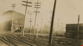
Edmonds and Kingsway
https://search.heritageburnaby.ca/link/archivedescription36162
- Repository
- City of Burnaby Archives
- Date
- 1913
- Collection/Fonds
- Burnaby Historical Society fonds
- Description Level
- Item
- Physical Description
- 1 photograph : sepia ; 7 x 12 cm
- Scope and Content
- Photograph of the railway junction and hydro poles at Edmonds and Kingsway, and the "triangle block" on the far right. A touring car is visible moving though the backgound.
- Repository
- City of Burnaby Archives
- Date
- 1913
- Collection/Fonds
- Burnaby Historical Society fonds
- Physical Description
- 1 photograph : sepia ; 7 x 12 cm
- Description Level
- Item
- Record No.
- 230-007
- Access Restriction
- No restrictions
- Reproduction Restriction
- No known restrictions
- Accession Number
- BHS1989-22
- Scope and Content
- Photograph of the railway junction and hydro poles at Edmonds and Kingsway, and the "triangle block" on the far right. A touring car is visible moving though the backgound.
- Media Type
- Photograph
- Notes
- Title based on contents of photograph
- Geographic Access
- Edmonds Street
- Kingsway
- Historic Neighbourhood
- Edmonds (Historic Neighbourhood)
- Planning Study Area
- Edmonds Area
Images
![Edmonds and Kingsway, 1912 (date of original), copied [1997] thumbnail](/media/hpo/_Data/_Archives_Images/_Unrestricted/316/350-015.jpg?width=280)
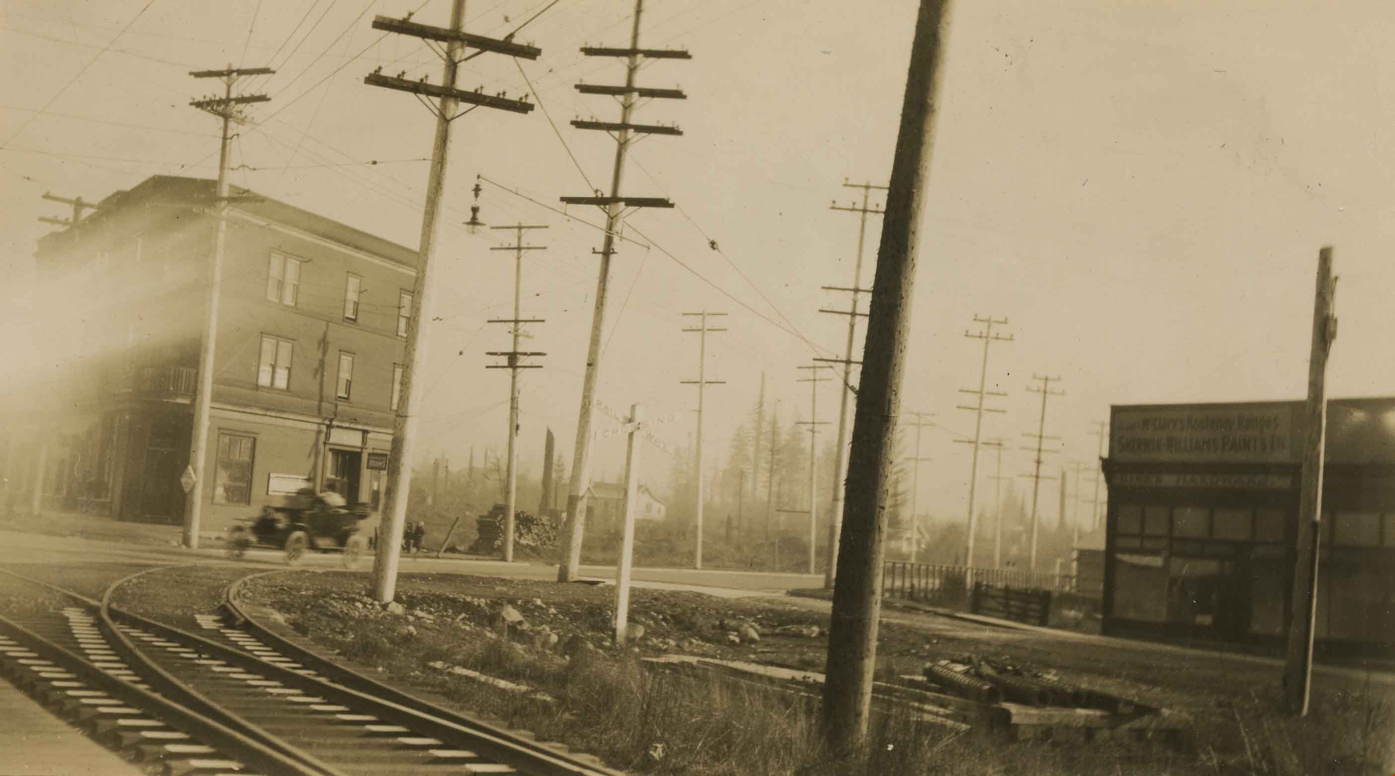
Edmonds and Kingsway
https://search.heritageburnaby.ca/link/archivedescription37321
- Repository
- City of Burnaby Archives
- Date
- 1912 (date of original), copied [1997]
- Collection/Fonds
- Burnaby Historical Society fonds
- Description Level
- Item
- Physical Description
- 1 photograph : b&w ; 9 x 12 cm print
- Scope and Content
- Photograph of the area near the Edmonds and Kingsway intersection. A British Columbia Electric Railway Company tram is visible in the centre and the station can be seen to the left.
- Repository
- City of Burnaby Archives
- Date
- 1912 (date of original), copied [1997]
- Collection/Fonds
- Burnaby Historical Society fonds
- Subseries
- Jim Wolf subseries
- Physical Description
- 1 photograph : b&w ; 9 x 12 cm print
- Description Level
- Item
- Record No.
- 350-015
- Access Restriction
- No restrictions
- Reproduction Restriction
- No known restrictions
- Accession Number
- BHS1997-09
- Scope and Content
- Photograph of the area near the Edmonds and Kingsway intersection. A British Columbia Electric Railway Company tram is visible in the centre and the station can be seen to the left.
- Media Type
- Photograph
- Notes
- Title based on contents of photograph.
- Geographic Access
- Edmonds Street
- Kingsway
- Historic Neighbourhood
- Edmonds (Historic Neighbourhood)
- Planning Study Area
- Richmond Park Area
Images
![Edmonds and Kingsway, 1912 (date of original), copied [1997] thumbnail](/media/hpo/_Data/_Archives_Images/_Unrestricted/316/350-015.jpg)
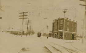
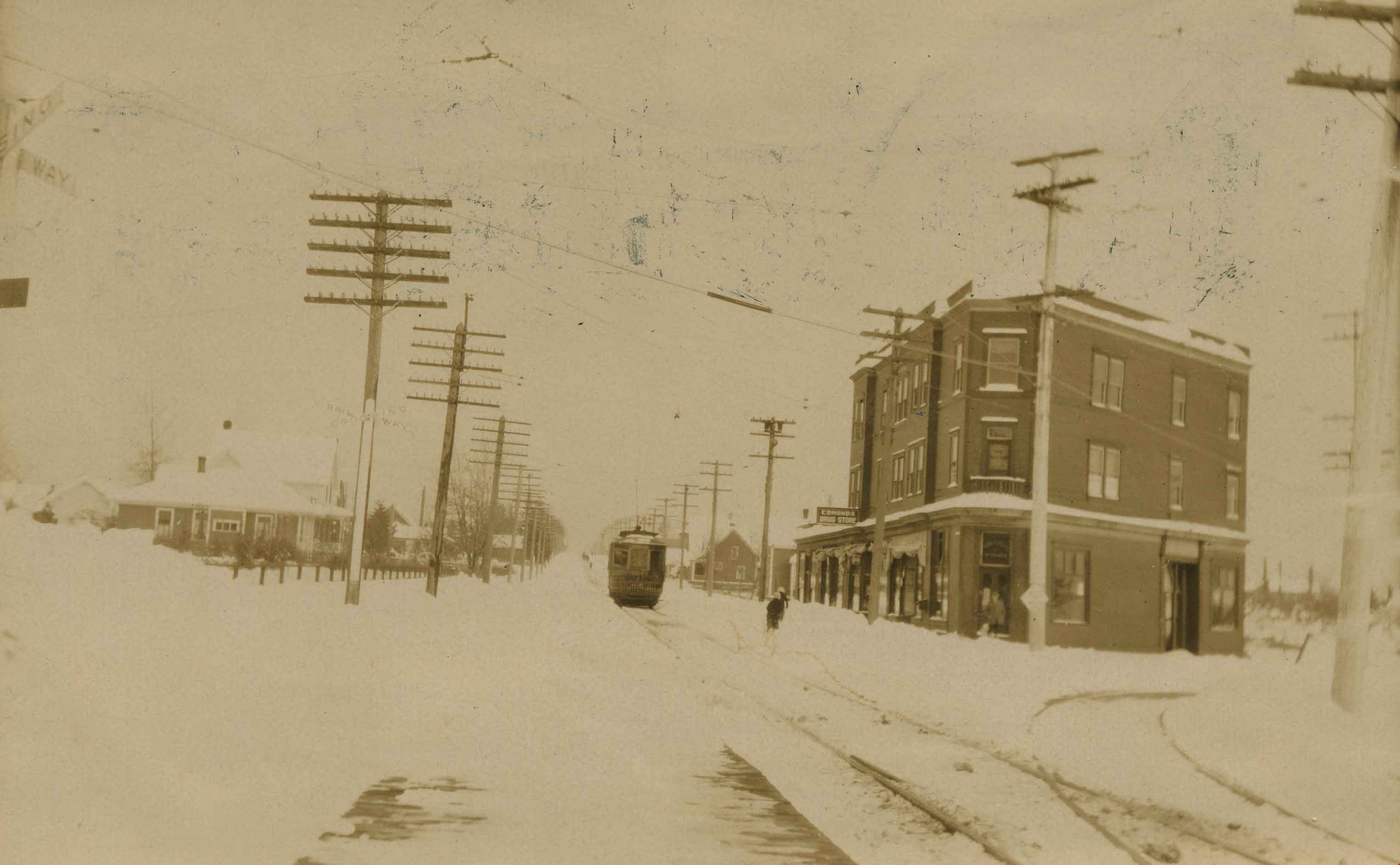
Edmonds and Kingsway tramline
https://search.heritageburnaby.ca/link/archivedescription36163
- Repository
- City of Burnaby Archives
- Date
- 1913
- Collection/Fonds
- Burnaby Historical Society fonds
- Description Level
- Item
- Physical Description
- 1 photograph : sepia ; 8 x 13 cm
- Scope and Content
- Photograph of the railway junction and hydro poles at Edmonds and Kingsway, with the "triangle block" on the left. A tram is visible moving along the snow covered line to New Westminister, via East Burnaby.
- Repository
- City of Burnaby Archives
- Date
- 1913
- Collection/Fonds
- Burnaby Historical Society fonds
- Physical Description
- 1 photograph : sepia ; 8 x 13 cm
- Description Level
- Item
- Record No.
- 230-008
- Access Restriction
- No restrictions
- Reproduction Restriction
- No known restrictions
- Accession Number
- BHS1989-22
- Scope and Content
- Photograph of the railway junction and hydro poles at Edmonds and Kingsway, with the "triangle block" on the left. A tram is visible moving along the snow covered line to New Westminister, via East Burnaby.
- Media Type
- Photograph
- Notes
- Title based on contents of photograph
- Geographic Access
- Edmonds Street
- Kingsway
- Historic Neighbourhood
- Edmonds (Historic Neighbourhood)
- Planning Study Area
- Edmonds Area
Images
![Granville Street looking south from Rogers building, [between 1908 and 1911] thumbnail](/media/hpo/_Data/_BVM_Images/1972/1972_0050_0002_002.jpg?width=280)
Granville Street looking south from Rogers building
https://search.heritageburnaby.ca/link/museumdescription1063
- Repository
- Burnaby Village Museum
- Date
- [between 1908 and 1911]
- Collection/Fonds
- Burnaby Village Museum Photograph collection
- Description Level
- Item
- Physical Description
- 1 photograph : b&w ; 6.1 x 10.7 cm mounted on paper 13.5 x 18.3 cm
- Scope and Content
- Photograph of Granville Street in Vancouver, looking south from the Roger's Building. The two tall buildings to the sides are under construction, and steam is blowing out from building chimneys. Busy street activities can be seen below with two trams running along the tracks.Inscribed on the scrapb…
- Repository
- Burnaby Village Museum
- Collection/Fonds
- Burnaby Village Museum Photograph collection
- Description Level
- Item
- Physical Description
- 1 photograph : b&w ; 6.1 x 10.7 cm mounted on paper 13.5 x 18.3 cm
- Scope and Content
- Photograph of Granville Street in Vancouver, looking south from the Roger's Building. The two tall buildings to the sides are under construction, and steam is blowing out from building chimneys. Busy street activities can be seen below with two trams running along the tracks.Inscribed on the scrapbook paper in white ink: "Granville Street / Looking South / From Rogers Building / Vancouver B.C."
- Geographic Access
- Vancouver
- Accession Code
- HV972.50.2
- Access Restriction
- No restrictions
- Reproduction Restriction
- No known restrictions
- Date
- [between 1908 and 1911]
- Media Type
- Photograph
- Scan Resolution
- 600
- Scan Date
- 2023-03-28
- Photographer
- Dean, H.M.
- Notes
- Title based on caption of photograph
Images
![Granville Street looking south from Rogers building, [between 1908 and 1911] thumbnail](/media/hpo/_Data/_BVM_Images/1972/1972_0050_0002_002.jpg)
![Granville Street, Vancouver, [1911] thumbnail](/media/hpo/_Data/_BVM_Images/1972/1972_0050_0006_001.jpg?width=280)
Granville Street, Vancouver
https://search.heritageburnaby.ca/link/museumdescription1067
- Repository
- Burnaby Village Museum
- Date
- [1911]
- Collection/Fonds
- Burnaby Village Museum Photograph collection
- Description Level
- Item
- Physical Description
- 1 photograph : b&w ; 8.0 x 10.2 cm
- Scope and Content
- Photograph of Granville Street, looking south. The two tall buildings to the sides are under construction. Busy street activities can be seen below with two trams running along the tracks. The old Vancouver Hotel is in view and the old courthouse (later the Vancouver Art Gallery) is in view faint…
- Repository
- Burnaby Village Museum
- Collection/Fonds
- Burnaby Village Museum Photograph collection
- Description Level
- Item
- Physical Description
- 1 photograph : b&w ; 8.0 x 10.2 cm
- Scope and Content
- Photograph of Granville Street, looking south. The two tall buildings to the sides are under construction. Busy street activities can be seen below with two trams running along the tracks. The old Vancouver Hotel is in view and the old courthouse (later the Vancouver Art Gallery) is in view faintly to the right of the photograph. An annoation on the back of the photograph reads, ""Granville St. - with OLD [underlined] / Vancouver Hotel across / from the Birks Building/ 1911/ (Court House in back of Van Hotel)."
- Geographic Access
- Vancouver
- Accession Code
- HV972.50.6
- Access Restriction
- No restrictions
- Reproduction Restriction
- No known restrictions
- Date
- [1911]
- Media Type
- Photograph
- Scan Resolution
- 600
- Scan Date
- 2023-04-04
- Photographer
- Dean, H.M.
- Notes
- Title based on contents of photograph
Images
![Granville Street, Vancouver, [1911] thumbnail](/media/hpo/_Data/_BVM_Images/1972/1972_0050_0006_001.jpg)
![Granville Street, Vancouver, [1910] thumbnail](/media/hpo/_Data/_BVM_Images/1972/1972_0050_0008_001.jpg?width=280)
Granville Street, Vancouver
https://search.heritageburnaby.ca/link/museumdescription1069
- Repository
- Burnaby Village Museum
- Date
- [1910]
- Collection/Fonds
- Burnaby Village Museum Photograph collection
- Description Level
- Item
- Physical Description
- 1 photograph : b&w ; 7.4 x 9.8 cm
- Scope and Content
- Photograph of Granville Street, looking north. Signs for "Fletchers Pianos" and the "Colonial Theatre" can be seen. The north shore is faintly visible across Burrard Inlet.
- Repository
- Burnaby Village Museum
- Collection/Fonds
- Burnaby Village Museum Photograph collection
- Description Level
- Item
- Physical Description
- 1 photograph : b&w ; 7.4 x 9.8 cm
- Scope and Content
- Photograph of Granville Street, looking north. Signs for "Fletchers Pianos" and the "Colonial Theatre" can be seen. The north shore is faintly visible across Burrard Inlet.
- Subjects
- Advertising Medium - Signs and Signboards
- Buildings - Commercial
- Geographic Features - Roads
- Geographic Access
- Vancouver
- Accession Code
- HV972.50.8
- Access Restriction
- No restrictions
- Reproduction Restriction
- No known restrictions
- Date
- [1910]
- Media Type
- Photograph
- Scan Resolution
- 600
- Scan Date
- 2023-04-04
- Photographer
- Dean, H.M.
- Notes
- Title based on contents of photograph
- An annotation on the back of the photograph reads, "Granville St. - 1910."
Images
![Granville Street, Vancouver, [1910] thumbnail](/media/hpo/_Data/_BVM_Images/1972/1972_0050_0008_001.jpg)
![Gwendoline Goodridge standing in doorway of Goodridge store, [191-] thumbnail](/media/hpo/_Data/_BVM_Images/2023/2023_0015_0003_001.jpg?width=280)
Gwendoline Goodridge standing in doorway of Goodridge store
https://search.heritageburnaby.ca/link/museumdescription20277
- Repository
- Burnaby Village Museum
- Date
- [191-]
- Collection/Fonds
- Burnaby Village Museum Photograph collection
- Description Level
- Item
- Physical Description
- 1 photograph : b&w negative ; 12.5 x 10 cm
- Scope and Content
- Photograph of Gwendoline Elston "Gwen" (Goodridge) Lister standing in the doorway of the Goodridge grocey store and post office located on Hastings Street in Burnaby. Signage on the windows and on the front of the store identify some of the trademarks of products sold in the store including "Royal …
- Repository
- Burnaby Village Museum
- Collection/Fonds
- Burnaby Village Museum Photograph collection
- Description Level
- Item
- Physical Description
- 1 photograph : b&w negative ; 12.5 x 10 cm
- Scope and Content
- Photograph of Gwendoline Elston "Gwen" (Goodridge) Lister standing in the doorway of the Goodridge grocey store and post office located on Hastings Street in Burnaby. Signage on the windows and on the front of the store identify some of the trademarks of products sold in the store including "Royal Crown Soap", "Salada Tea" and "Kellog's Cornflakes". Signage below window on right reads "POST OFFICE".
- Subjects
- Buildings - Commercial
- Buildings - Commercial - Grocery Stores
- Buildings - Public - Post Offices
- Geographic Access
- Hastings Street
- Accession Code
- BV023.15.3
- Access Restriction
- No restrictions
- Reproduction Restriction
- No known restrictions
- Date
- [191-]
- Media Type
- Photograph
- Scan Resolution
- 3200
- Scan Date
- 2023-09-21
- Notes
- Title based on contents of photograph
- 1 b&w contact sheet accompanying
Images
![Gwendoline Goodridge standing in doorway of Goodridge store, [191-] thumbnail](/media/hpo/_Data/_BVM_Images/2023/2023_0015_0003_001.jpg)
![Liquor Store, [191-?] thumbnail](/media/hpo/_Data/_BVM_Images/1972/1972_0148_0001_001.jpg?width=280)
Liquor Store
https://search.heritageburnaby.ca/link/museumdescription1098
- Repository
- Burnaby Village Museum
- Date
- [191-?]
- Collection/Fonds
- Burnaby Village Museum Photograph collection
- Description Level
- Item
- Physical Description
- 1 photograph : sepia ; 15.5 x 20.5 cm, mounted on card 24.5 x 29.5 cm
- Scope and Content
- Photograph of the interior of an unidentified Liquor Store. Four men are visible standing inside the store.
- Repository
- Burnaby Village Museum
- Collection/Fonds
- Burnaby Village Museum Photograph collection
- Description Level
- Item
- Physical Description
- 1 photograph : sepia ; 15.5 x 20.5 cm, mounted on card 24.5 x 29.5 cm
- Scope and Content
- Photograph of the interior of an unidentified Liquor Store. Four men are visible standing inside the store.
- Subjects
- Buildings - Commercial
- Accession Code
- HV972.148.1
- Access Restriction
- No restrictions
- Date
- [191-?]
- Media Type
- Photograph
- Scan Resolution
- 600
- Scan Date
- 2023-04-18
- Notes
- Title based on contents of photograph
Images
![Liquor Store, [191-?] thumbnail](/media/hpo/_Data/_BVM_Images/1972/1972_0148_0001_001.jpg)


Lost in the 50's Drive-In sign
https://search.heritageburnaby.ca/link/archivedescription98682
- Repository
- City of Burnaby Archives
- Date
- 2022
- Collection/Fonds
- Disappearing Burnaby collection
- Description Level
- Item
- Physical Description
- 1 photograph (jpeg) : col.
- Scope and Content
- Photograph of the historic "Arrow Neon Sign" at 50's Burgers, a restaurant located at 7741 Edmonds Street. The photograph depicts the sign, which reads: "Lost in the 50's Drive-In," against the sky at dusk.
- Repository
- City of Burnaby Archives
- Date
- 2022
- Collection/Fonds
- Disappearing Burnaby collection
- Physical Description
- 1 photograph (jpeg) : col.
- Description Level
- Item
- Record No.
- 634-029
- Access Restriction
- No restrictions
- Reproduction Restriction
- No restrictions
- Accession Number
- 2022-14
- Scope and Content
- Photograph of the historic "Arrow Neon Sign" at 50's Burgers, a restaurant located at 7741 Edmonds Street. The photograph depicts the sign, which reads: "Lost in the 50's Drive-In," against the sky at dusk.
- Media Type
- Photograph
- Photographer
- Cheung, Nakita
- Notes
- Title taken from the associated blog post
- Associated blog post: https://disappearingburnaby.wordpress.com/2022/06/30/lost-in-the-50s-drive-in/
- Geographic Access
- Edmonds Street
- Street Address
- 7741 Edmonds Street
- Historic Neighbourhood
- East Burnaby (Historic Neighbourhood)
- Planning Study Area
- Lakeview-Mayfield Area
Images


Oh! Zhhu Sam
https://search.heritageburnaby.ca/link/archivedescription98681
- Repository
- City of Burnaby Archives
- Date
- 2022
- Collection/Fonds
- Disappearing Burnaby collection
- Description Level
- Item
- Physical Description
- 1 photograph (jpeg) : col.
- Scope and Content
- Photograph of the 7500 block of Edmonds Street at dusk. The photograph is taken from across Edmonds Street and depicts two commercial buildings: Oh! Zzhu Sam Korean Restaurant and the European Butcher Boy Delicatessen & Grocery. Oh! Zzhu Sam, located at 7506 Edmonds Street, was constructed in 1976.…
- Repository
- City of Burnaby Archives
- Date
- 2022
- Collection/Fonds
- Disappearing Burnaby collection
- Physical Description
- 1 photograph (jpeg) : col.
- Description Level
- Item
- Record No.
- 634-028
- Access Restriction
- No restrictions
- Reproduction Restriction
- No restrictions
- Accession Number
- 2022-14
- Scope and Content
- Photograph of the 7500 block of Edmonds Street at dusk. The photograph is taken from across Edmonds Street and depicts two commercial buildings: Oh! Zzhu Sam Korean Restaurant and the European Butcher Boy Delicatessen & Grocery. Oh! Zzhu Sam, located at 7506 Edmonds Street, was constructed in 1976. Residential houses border the restaurant and grocery store, and a bus shelter, municipal garbage can, and the restaurant's illuminated neon sign stand in front of the buildings.
- Subjects
- Buildings - Commercial
- Buildings - Commercial - Grocery Stores
- Buildings - Commercial - Restaurants
- Media Type
- Photograph
- Photographer
- Cheung, Nakita
- Notes
- Title taken from the associated blog post
- Associated blog post: https://disappearingburnaby.wordpress.com/2022/07/29/oh-zzhu-sam/
- Geographic Access
- Edmonds Street
- Street Address
- 7506 Edmonds Street
- Historic Neighbourhood
- Edmonds (Historic Neighbourhood)
- Planning Study Area
- Edmonds Area
Images


On On Wonton House
https://search.heritageburnaby.ca/link/archivedescription98670
- Repository
- City of Burnaby Archives
- Date
- 2022
- Collection/Fonds
- Disappearing Burnaby collection
- Description Level
- Item
- Physical Description
- 1 photograph (jpeg) : col.
- Scope and Content
- Photograph of the exterior of the On On Wonton House restaurant, located at 5640 Kingsway. The photograph is taken from across Kingsway at night. The building, which was constructed in 1959, is lit up with lights and a bright sign, and several cars are parked in the lot in front of the restaurant.
- Repository
- City of Burnaby Archives
- Date
- 2022
- Collection/Fonds
- Disappearing Burnaby collection
- Physical Description
- 1 photograph (jpeg) : col.
- Description Level
- Item
- Record No.
- 634-017
- Access Restriction
- No restrictions
- Reproduction Restriction
- No restrictions
- Accession Number
- 2022-14
- Scope and Content
- Photograph of the exterior of the On On Wonton House restaurant, located at 5640 Kingsway. The photograph is taken from across Kingsway at night. The building, which was constructed in 1959, is lit up with lights and a bright sign, and several cars are parked in the lot in front of the restaurant.
- Media Type
- Photograph
- Photographer
- Cheung, Nakita
- Notes
- Title taken from the associated blog post
- Associated blog post: https://disappearingburnaby.wordpress.com/2022/06/06/on-on-wonton-house/
- Geographic Access
- Kingsway
- Street Address
- 5640 Kingsway
- Historic Neighbourhood
- Central Park (Historic Neighbourhood)
- Planning Study Area
- Windsor Area
Images


Trafalgar Market
https://search.heritageburnaby.ca/link/archivedescription98665
- Repository
- City of Burnaby Archives
- Date
- 2022
- Collection/Fonds
- Disappearing Burnaby collection
- Description Level
- Item
- Physical Description
- 1 photograph (jpeg) : col.
- Scope and Content
- Photograph of the intersection of Imperial Street and Sussex Avenue at night and in the rain. The photograph shows the Trafalgar Market grocery store (located at 4398 Imperial Street; the building was constructed in 1940) on the corner, with a large display of flowers for sale under the awning in f…
- Repository
- City of Burnaby Archives
- Date
- 2022
- Collection/Fonds
- Disappearing Burnaby collection
- Physical Description
- 1 photograph (jpeg) : col.
- Description Level
- Item
- Record No.
- 634-012
- Access Restriction
- No restrictions
- Reproduction Restriction
- No restrictions
- Accession Number
- 2022-14
- Scope and Content
- Photograph of the intersection of Imperial Street and Sussex Avenue at night and in the rain. The photograph shows the Trafalgar Market grocery store (located at 4398 Imperial Street; the building was constructed in 1940) on the corner, with a large display of flowers for sale under the awning in front of the store. The street and traffic lights are reflected in the puddles on the road, and cars and other businesses are visible along Imperial Street.
- Subjects
- Buildings - Commercial
- Buildings - Commercial - Grocery Stores
- Buildings - Commercial - Stores
- Geographic Features - Roads
- Media Type
- Photograph
- Photographer
- Cheung, Nakita
- Notes
- Title taken from the associated blog post
- Associated blog post: https://disappearingburnaby.wordpress.com/2022/02/20/imperial-manor-2/
- Geographic Access
- Imperial Street
- Sussex Avenue
- Street Address
- 4398 Imperial Street
- Historic Neighbourhood
- Central Park (Historic Neighbourhood)
- Planning Study Area
- Sussex-Nelson Area
Images
