Narrow Results By
Subject
- Arts - Paintings 2
- Buildings - Civic - Hospitals 12
- Buildings - Commercial - Bakeries 2
- Buildings - Commercial - Offices 1
- Buildings - Recreational 1
- Buildings - Residential - Houses 4
- Buildings - Residential - Seniors Housing 2
- Buildings - Schools 13
- Clothing - Military Uniforms 1
- Events 1
- Events - Anniversaries 1
- Events - Fundraising 1
![Smith family home, [between 1914 and 1919] (date of original), copied 1992 thumbnail](/media/hpo/_Data/_Archives_Images/_Unrestricted/315/315-080.jpg?width=280)
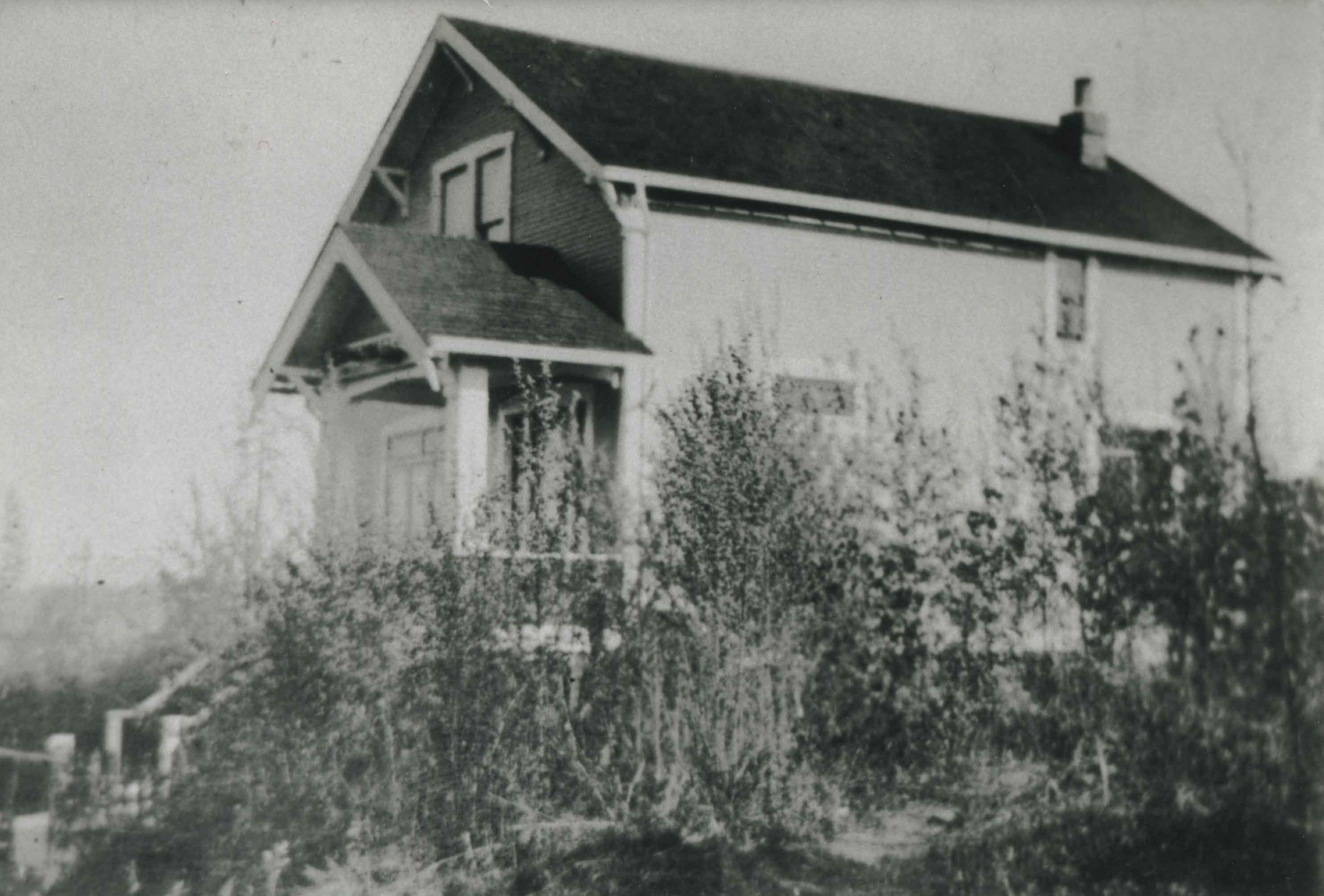
Smith family home
https://search.heritageburnaby.ca/link/archivedescription36725
- Repository
- City of Burnaby Archives
- Date
- [between 1914 and 1919] (date of original), copied 1992
- Collection/Fonds
- Burnaby Historical Society fonds
- Description Level
- Item
- Physical Description
- 1 photograph : b&w ; 10.1 x 14.9 cm print
- Scope and Content
- Photograph of the home of Agnes and Nathaniel Smith and their family at 4526 Inman Avenue. Two women and a man sitting on the stairs and porch. It was built the winter of 1913-14.
- Repository
- City of Burnaby Archives
- Date
- [between 1914 and 1919] (date of original), copied 1992
- Collection/Fonds
- Burnaby Historical Society fonds
- Subseries
- Burnaby Centennial Anthology subseries
- Physical Description
- 1 photograph : b&w ; 10.1 x 14.9 cm print
- Description Level
- Item
- Record No.
- 315-080
- Access Restriction
- No restrictions
- Reproduction Restriction
- No known restrictions
- Accession Number
- BHS1994-04
- Scope and Content
- Photograph of the home of Agnes and Nathaniel Smith and their family at 4526 Inman Avenue. Two women and a man sitting on the stairs and porch. It was built the winter of 1913-14.
- Subjects
- Buildings - Residential - Houses
- Media Type
- Photograph
- Notes
- Title based on contents of photograph
- Geographic Access
- Inman Avenue
- Street Address
- 4526 Inman Avenue
- Historic Neighbourhood
- Central Park (Historic Neighbourhood)
- Planning Study Area
- Cascade-Schou Area
Images
![Smith family home, [between 1914 and 1919] (date of original), copied 1992 thumbnail](/media/hpo/_Data/_Archives_Images/_Unrestricted/315/315-080.jpg)
![South Burnaby Metro Club retrospective, [2002] thumbnail](/media/hpo/_Data/_Archives_Images/_Unrestricted/535/535-2779-5.jpg?width=280)
South Burnaby Metro Club retrospective
https://search.heritageburnaby.ca/link/archivedescription97404
- Repository
- City of Burnaby Archives
- Date
- [2002]
- Collection/Fonds
- Burnaby NewsLeader photograph collection
- Description Level
- File
- Physical Description
- 6 photographs (tiff) : col.
- Scope and Content
- File contains photographs related to the South Burnaby Metro Club's history that were collected for a feature on the Club. Photographs depict SBMC events and soccer games, and historical photographs of the SBMC's buildings and baseball team from 1963.
- Repository
- City of Burnaby Archives
- Date
- [2002]
- Collection/Fonds
- Burnaby NewsLeader photograph collection
- Physical Description
- 6 photographs (tiff) : col.
- Description Level
- File
- Record No.
- 535-2779
- Access Restriction
- No restrictions
- Reproduction Restriction
- No restrictions
- Accession Number
- 2018-12
- Scope and Content
- File contains photographs related to the South Burnaby Metro Club's history that were collected for a feature on the Club. Photographs depict SBMC events and soccer games, and historical photographs of the SBMC's buildings and baseball team from 1963.
- Names
- South Burnaby Metro Club
- Media Type
- Photograph
- Photographer
- Bartel, Mario
- Notes
- Title based on caption
- Collected by editorial for use in a September 2002 issue of the Burnaby NewsLeader
- Caption from metadata for 535-2779-2: "Kyle Sussey-Perry, 6, prepares to give it his all at South Metro Baseball Club's Run, Hit and Throw competition on Saturday. More than 100 players, aged 5-13, tested their baseball abilities, with the winners going on to a provincial competition at Nat Bailey Stadium, with a chance to go to the national finals at Toronto's Skydome."
- Caption from metadata for 535-2779-3: "A South Burnaby Metro Club forward knocks his Wesburn opponent off the ball in U-16 Silver action at Wesburn Park in the annual Wesburn Gold/Silver Soccer Tournament."
- Caption from metadata for 535-2779-4: "A South Burnaby Metro Club forward knocks his Wesburn opponent off the ball in U-16 Silver action at Wesburn Park in the annual Wesburn Gold/Silver Soccer Tournament."
- Geographic Access
- Wesburn Park
- Historic Neighbourhood
- Broadview (Historic Neighbourhood)
- Planning Study Area
- Cascade-Schou Area
Images
![South Burnaby Metro Club retrospective, [2002] thumbnail](/media/hpo/_Data/_Archives_Images/_Unrestricted/535/535-2779-5.jpg)
![Standen family, [191-] (date of original), copied 1992 thumbnail](/media/hpo/_Data/_Archives_Images/_Unrestricted/315/315-081.jpg?width=280)
Standen family
https://search.heritageburnaby.ca/link/archivedescription36726
- Repository
- City of Burnaby Archives
- Date
- [191-] (date of original), copied 1992
- Collection/Fonds
- Burnaby Historical Society fonds
- Description Level
- Item
- Physical Description
- 1 photograph : b&w ; 10.1 x 14.9 cm print
- Scope and Content
- Photograph of Mr. and Mrs. Standen and their daughter, Annie, beside a team of horses. The driver is unidentified.
- Repository
- City of Burnaby Archives
- Date
- [191-] (date of original), copied 1992
- Collection/Fonds
- Burnaby Historical Society fonds
- Subseries
- Burnaby Centennial Anthology subseries
- Physical Description
- 1 photograph : b&w ; 10.1 x 14.9 cm print
- Description Level
- Item
- Record No.
- 315-081
- Access Restriction
- No restrictions
- Reproduction Restriction
- No restrictions
- Accession Number
- BHS1994-04
- Scope and Content
- Photograph of Mr. and Mrs. Standen and their daughter, Annie, beside a team of horses. The driver is unidentified.
- Names
- Standen, Annie
- Media Type
- Photograph
- Notes
- Title based on contents of photograph
- Geographic Access
- Fir Street
- Historic Neighbourhood
- Central Park (Historic Neighbourhood)
- Planning Study Area
- Cascade-Schou Area
Images
![Standen family, [191-] (date of original), copied 1992 thumbnail](/media/hpo/_Data/_Archives_Images/_Unrestricted/315/315-081.jpg)
![Subdivision plans in New Westminster District Group 1 – Burnaby
, [1890-1910] thumbnail](/media/hpo/_Data/_BVM_Cartographic_Material/1977/1977_0093_0014a_001.jpg?width=280)
Subdivision plans in New Westminster District Group 1 – Burnaby
https://search.heritageburnaby.ca/link/museumdescription6983
- Repository
- Burnaby Village Museum
- Date
- [1890-1910]
- Collection/Fonds
- Burnaby Village Museum Map collection
- Description Level
- File
- Physical Description
- 4 plans : blueprint ink on paper mounted on 2 sides of cardboard 76 x 102 cm
- Scope and Content
- Item consists of a large board of two New Westminster District Gp 1 - subdivision plans mounted on one side and two New Westminster District Gp 1 - subdivision plans mounted on the other side. Side A: 1. Blueprint "Plan of / Subdivision of Lot No. 69 / Group One / New Westminster District / Pro…
- Repository
- Burnaby Village Museum
- Collection/Fonds
- Burnaby Village Museum Map collection
- Description Level
- File
- Physical Description
- 4 plans : blueprint ink on paper mounted on 2 sides of cardboard 76 x 102 cm
- Material Details
- Scales [between 1:1584 and 1:3168]
- Index number on edge of board reads: "14"
- Scope and Content
- Item consists of a large board of two New Westminster District Gp 1 - subdivision plans mounted on one side and two New Westminster District Gp 1 - subdivision plans mounted on the other side. Side A: 1. Blueprint "Plan of / Subdivision of Lot No. 69 / Group One / New Westminster District / Property of Ernest Buse, Esq. / Scale 3 chs = 1 in. / Map No 290". Plan is signed by "Garden, Hermon and Burwell, Dom. Land Surveyor" (Geographic location: Burnaby) 2. Blueprint "Plan / of Subdivision / of Lots 1-19, 36-53 and 69-75 inclusive / in the Subdivision / of / Lot 30 / Group One / New Westminster District / Scale 2 chs = 1 in. Map No 631". Plan is signed by "Jno [sic] Strathern [sic] P.L.S." Names and Lot numbers are handwritten in red pencil in sections along Douglas Road and read: "20 - F / 21 - Fitherstruhaul [sic] / 22 - J.S. Craig / 23 - McGill & Dill / 24 / 25 / 26 / 27 / 28 - School / 29 - School / 30 - D. McDownall / 31 - W.J. Troloow [sic] / 32 - N.C. Nelson / 33 - _[sic] McGill / 34 - T.S.[sic] Craig / 35" (Geographic location: Burnaby) Side B: 1.Blueprint "Plan / of Subdivision / of Centre Portion / of Lot 28 / Group One / New Westminster District / Scale 200' = 1" / Map No 627". Plan is signed by "Jno Strathern / P.L.S." (Geographic location: Burnaby) 2. Blueprint "Plan / of Subdivision / of N.1/2 Lot 100 and S.1/2 Lot 101, / Group One / New Westminster District, BC / Scale 4 chs = 1 in." (Geographic location: Burnaby)
- Names
- Strathern, John
- Accession Code
- HV977.93.14
- Access Restriction
- No restrictions
- Reproduction Restriction
- No known restrictions
- Date
- [1890-1910]
- Media Type
- Cartographic Material
- Historic Neighbourhood
- Broadview (Historic Neighbourhood)
- East Burnaby (Historic Neighbourhood)
- Planning Study Area
- Cascade-Schou Area
- West Central Valley Area
- Second Street Area
- Lake City Area
- Scan Resolution
- 300
- Scale
- 72
- Notes
- Title based on contents of file
- Scale is measured in chains and feet. (One chain equals 792 inches)
- The term "Lot" can also refer to a "District Lot”
Images
![Subdivision plans in New Westminster District Group 1 – Burnaby
, [1890-1910] thumbnail](/media/hpo/_Data/_BVM_Cartographic_Material/1977/1977_0093_0014a_001.jpg)

Telford family home
https://search.heritageburnaby.ca/link/archivedescription37028
- Repository
- City of Burnaby Archives
- Date
- 1915 (date of original), copied 1992
- Collection/Fonds
- Burnaby Historical Society fonds
- Description Level
- Item
- Physical Description
- 1 photograph : b&w ; 10.1 x 14.9 cm print
- Scope and Content
- Photograph of the Telford family home on Manor Street.
- Repository
- City of Burnaby Archives
- Date
- 1915 (date of original), copied 1992
- Collection/Fonds
- Burnaby Historical Society fonds
- Subseries
- Burnaby Centennial Anthology subseries
- Physical Description
- 1 photograph : b&w ; 10.1 x 14.9 cm print
- Description Level
- Item
- Record No.
- 315-491
- Access Restriction
- No restrictions
- Reproduction Restriction
- No known restrictions
- Accession Number
- BHS1994-04
- Scope and Content
- Photograph of the Telford family home on Manor Street.
- Subjects
- Buildings - Residential - Houses
- Media Type
- Photograph
- Notes
- Title based on contents of photograph
- Geographic Access
- Manor Street
- Historic Neighbourhood
- Broadview (Historic Neighbourhood)
- Planning Study Area
- Cascade-Schou Area
Images