Narrow Results By
Subject
- Accidents - Automobile Accidents 1
- Agriculture - Farms 2
- Buildings - Recreational - Outdoor Swimming Pools 1
- Buildings - Residential - Condominiums 1
- Buildings - Residential - Houses 2
- Buildings - Schools 2
- Documentary Artifacts - Postcards 1
- Geographic Features - Lakes and Ponds 2
- Geographic Features - Neighbourhoods 1
- Geographic Features - Roads 1
- Natural Phenomena - Fires 1
- Occupations - Fire Fighters 1

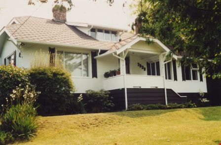
Arthur Long Residence
https://search.heritageburnaby.ca/link/landmark560
- Repository
- Burnaby Heritage Planning
- Description
- Residential building.
- Associated Dates
- 1912
- Street View URL
- Google Maps Street View
- Repository
- Burnaby Heritage Planning
- Geographic Access
- Stanley Street
- Associated Dates
- 1912
- Description
- Residential building.
- Heritage Value
- Arthur Long, of the Water Rights Office of Victoria, purchased this land from neighbour Henry Ramsay, and built this beautiful Arts and Crafts styled home. The house appears to have many similarities to the neighbouring Ramsay House, which was designed by Vancouver architect R. Mackay Fripp. The house has retained its original complex gabled roof, triangular eave brackets and horizontal siding.
- Locality
- Burnaby Lake
- Historic Neighbourhood
- Burnaby Lake (Historic Neighbourhood)
- Planning Study Area
- Lakeview-Mayfield Area
- Ownership
- Private
- Street Address
- 7828 Stanley Street
- Street View URL
- Google Maps Street View
Images


Burnaby Lake Neighbourhood
https://search.heritageburnaby.ca/link/landmark755
- Repository
- Burnaby Heritage Planning
- Associated Dates
- 1905-1924
- Heritage Value
- Along with logging and sawmills, Burnaby became known as a prime agricultural area and the Burnaby Lake Neighbourhood saw the development of many vegetable and fruit farms. Growers in the Burnaby and Deer Lake districts took their produce to the tram line on Edmonds Street and shipped it to markets in New Westminster and Vancouver on a specially designed interurban freight car that was open-sided for easy loading. The car's canvas curtains which sometimes came loose and flapped like wings in the wind led people to dub it "the flying dutchman." Most Burnaby fruit and vegetable growers depended on seasonal Chinese work forces and other local Chinese farm residents to oversee operations; these workers being recruited from New Westminsters' Asian community. Besides being good farmers, Burnaby Lake's early residents fostered a strong sense of community. Both L. Claude Hill and his brother Bernard were elected to Burnaby Municipal council and Bernard was the one who knocked on doors to find enough children to meet the qualifications for establishing a school in the district.
- Historic Neighbourhood
- Burnaby Lake (Historic Neighbourhood)
- Planning Study Area
- Morley-Buckingham Area
- Lakeview-Mayfield Area
Images


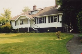
Henry & Elsa Ramsay Residence
https://search.heritageburnaby.ca/link/landmark592
- Repository
- Burnaby Heritage Planning
- Description
- Residential building.
- Associated Dates
- 1912
- Street View URL
- Google Maps Street View
- Repository
- Burnaby Heritage Planning
- Geographic Access
- Stanley Street
- Associated Dates
- 1912
- Description
- Residential building.
- Heritage Value
- This house was built for Henry Ramsay and his wife, Elsa Kirby (née Burnett), who were married at Holy Trinity Cathedral in New Westminster in 1910. Henry was a real estate agent, originally from Newcastle-on-Tyne, England. Beautifully designed in the Arts and Crafts style, it follows the ideals of the movement in the use of native materials. The wooden construction includes timber porch and roof brackets. The roofline is of a notably low pitch. English-born architect Robert Mackay Fripp (1858-1917) had a varied career working at various times in England, New Zealand and Los Angeles. Fripp found the opportunity in British Columbia to promote his passion for British Arts and Crafts aesthetics through a series of residential and institutional commissions. The Ramsay Residence was built at the height of the Arts and Crafts movement, and Fripp’s output during this period was prolific; his residential designs ranged from modest California bungalows to stately Tudor Revival homes in Shaughnessy, Point Grey and Kerrisdale. This elegant house was built by contractor C.G. Bowden.
- Locality
- Burnaby Lake
- Historic Neighbourhood
- Burnaby Lake (Historic Neighbourhood)
- Planning Study Area
- Lakeview-Mayfield Area
- Architect
- Robert Mackay Fripp
- Area
- 1211.15
- Contributing Resource
- Building
- Ownership
- Private
- Street Address
- 7864 Stanley Street
- Street View URL
- Google Maps Street View
Images


Lakeview-Mayfield Neighbourhood
https://search.heritageburnaby.ca/link/landmark830
- Repository
- Burnaby Heritage Planning
- Associated Dates
- 1955-2008
- Heritage Value
- Like many other areas of the City, the Lakeview-Mayfield Neighbourhood was subdivided during the 1950s post-war building boom. Pockets of newer homes were built in the 1970s, and the neighbourhood retained its character as a primarily residential area. The neighbourhood is bordered to the east by Robert Burnaby Park.
- Planning Study Area
- Lakeview-Mayfield Area
Images

![Burnaby Bees baseball game, [2002] thumbnail](/media/hpo/_Data/_Archives_Images/_Unrestricted/535/535-2593-1.jpg?width=280)
Burnaby Bees baseball game
https://search.heritageburnaby.ca/link/archivedescription97065
- Repository
- City of Burnaby Archives
- Date
- [2002]
- Collection/Fonds
- Burnaby NewsLeader photograph collection
- Description Level
- File
- Physical Description
- 2 photographs (tiff) : col.
- Scope and Content
- File contains photographs of a baseball game between the Burnaby Bees and the North Shore Tribe at Robert Burnaby Park. Photographs depict Burnaby player Dave McElroy in action with North Shore player Jarvis Strutt and another unidentified Burnaby player.
- Repository
- City of Burnaby Archives
- Date
- [2002]
- Collection/Fonds
- Burnaby NewsLeader photograph collection
- Physical Description
- 2 photographs (tiff) : col.
- Description Level
- File
- Record No.
- 535-2593
- Access Restriction
- No restrictions
- Reproduction Restriction
- No restrictions
- Accession Number
- 2018-12
- Scope and Content
- File contains photographs of a baseball game between the Burnaby Bees and the North Shore Tribe at Robert Burnaby Park. Photographs depict Burnaby player Dave McElroy in action with North Shore player Jarvis Strutt and another unidentified Burnaby player.
- Subjects
- Sports - Baseball
- Media Type
- Photograph
- Photographer
- Bartel, Mario
- Notes
- Title based on caption
- Collected by editorial for use in a June 2002 issue of the Burnaby NewsLeader
- Caption from metadata for 535-2593-1: "Burnaby Bees' Dave McElroy can't get a handle on the ball in time to tag North Shore baserunner Jarvis Strutt, in the first game of their BC Junior Baseball game, at Robert Burnaby Park."
- Caption from metadata for 535-2593-2: "North Shore Tribes' second baseman Jarvis Strutt, makes the pivot on a Burnaby Bees' baserunner, in the first game of their BC Junior Baseball doubleheader, Sunday at Robert Burnaby Park."
- Geographic Access
- Robert Burnaby Park
- Wedgewood Street
- Street Address
- 8155 Wedgewood Street
- Historic Neighbourhood
- East Burnaby (Historic Neighbourhood)
- Planning Study Area
- Lakeview-Mayfield Area
Images
![Burnaby Bees baseball game, [2002] thumbnail](/media/hpo/_Data/_Archives_Images/_Unrestricted/535/535-2593-1.jpg)
![Deer Lake, [1914] thumbnail](/media/hpo/_Data/_BVM_Images/1971/197200110018.jpg?width=280)
Deer Lake
https://search.heritageburnaby.ca/link/museumdescription3104
- Repository
- Burnaby Village Museum
- Date
- [1914]
- Collection/Fonds
- Burnaby Village Museum Photograph collection
- Description Level
- Item
- Physical Description
- 1 photograph : b&w glass negative ; 16.4 x 21.2 cm
- Scope and Content
- Photograph of the north shore of Deer Lake as seen from the south shore. According to an earlier 1988 catalogue record, in view from left to right are: H.T. Ceperley's "Fairacres," The Mathers "Altnadene," and the Anderson house on the hill. On shoreline are the Hart's boathouse and beach cottage…
- Repository
- Burnaby Village Museum
- Collection/Fonds
- Burnaby Village Museum Photograph collection
- Description Level
- Item
- Physical Description
- 1 photograph : b&w glass negative ; 16.4 x 21.2 cm
- Scope and Content
- Photograph of the north shore of Deer Lake as seen from the south shore. According to an earlier 1988 catalogue record, in view from left to right are: H.T. Ceperley's "Fairacres," The Mathers "Altnadene," and the Anderson house on the hill. On shoreline are the Hart's boathouse and beach cottage and the Woodward's boathouse.
- Geographic Access
- Deer Lake Avenue
- Street Address
- 6490 Deer Lake Avenue
- 6344 Deer Lake Avenue
- Accession Code
- HV972.11.18
- Access Restriction
- No restrictions
- Reproduction Restriction
- No known restrictions
- Date
- [1914]
- Media Type
- Photograph
- Historic Neighbourhood
- Burnaby Lake (Historic Neighbourhood)
- Planning Study Area
- Lakeview-Mayfield Area
- Related Material
- For other shots of the Deer Lake in the same accession, see HV972.11.6 and HV972.11.16
- Scan Resolution
- 300
- Scan Date
- 14/8/2006
- Scale
- 100
- Notes
- Title based on contents of photograph
- 1 b&w contact print accompanying negative
Images
![Deer Lake, [1914] thumbnail](/media/hpo/_Data/_BVM_Images/1971/197200110018.jpg)
![Douglas Road, Burnaby, [1908] thumbnail](/media/hpo/_Data/_Archives_Images/_Unrestricted/371/449-009.jpg?width=280)
Douglas Road, Burnaby
https://search.heritageburnaby.ca/link/archivedescription38514
- Repository
- City of Burnaby Archives
- Date
- [1908]
- Collection/Fonds
- Burnaby Historical Society fonds
- Description Level
- Item
- Physical Description
- 1 photograph : sepia postcard ; 8.8 x 14 cm
- Scope and Content
- Photographic postcard taken looking northwest along Douglas Road (now Canada Way) near Stanley Street. Two unidentified people are standing next to a wooden fence running alongside the road (above Lubbock's Creek) and a number of houses (including the Sprott house) are visible in the background. To…
- Repository
- City of Burnaby Archives
- Date
- [1908]
- Collection/Fonds
- Burnaby Historical Society fonds
- Subseries
- Photographs subseries
- Physical Description
- 1 photograph : sepia postcard ; 8.8 x 14 cm
- Description Level
- Item
- Record No.
- 449-009
- Access Restriction
- No restrictions
- Reproduction Restriction
- No known restrictions
- Accession Number
- BHS2007-04
- Scope and Content
- Photographic postcard taken looking northwest along Douglas Road (now Canada Way) near Stanley Street. Two unidentified people are standing next to a wooden fence running alongside the road (above Lubbock's Creek) and a number of houses (including the Sprott house) are visible in the background. To the right is Burnaby Lake. Stamped at the top of the postcard is "Douglas Road, Burnaby / New Westminster BC."
- Subjects
- Geographic Features - Lakes and Ponds
- Documentary Artifacts - Postcards
- Geographic Features - Roads
- Media Type
- Photograph
- Geographic Access
- Douglas Road
- Stanley Street
- Canada Way
- Deer Lake
- Historic Neighbourhood
- Burnaby Lake (Historic Neighbourhood)
- Planning Study Area
- Lakeview-Mayfield Area
Images
![Douglas Road, Burnaby, [1908] thumbnail](/media/hpo/_Data/_Archives_Images/_Unrestricted/371/449-009.jpg)
![Fraser Valley Nurseries, [191-?] (date of original), copied 1977 thumbnail](/media/hpo/_Data/_BVM_Images/1977/1977_0099_0017_001.jpg?width=280)
Fraser Valley Nurseries
https://search.heritageburnaby.ca/link/museumdescription575
- Repository
- Burnaby Village Museum
- Date
- [191-?] (date of original), copied 1977
- Collection/Fonds
- Burnaby Village Museum Photograph collection
- Description Level
- Item
- Physical Description
- 1 photograph : b&w ; 20.32 x 25.4 cm
- Scope and Content
- Photograph of the grounds of the Fraser Valley Nurseries. The grounds are fenced with wire and wooden posts.There is a large sign on the left of the photograph that reads "The Fraser Valley Nurseries, Ltd." There are a few barns or sheds on the nursery grounds. Behind the nursery can be seen a la…
- Repository
- Burnaby Village Museum
- Collection/Fonds
- Burnaby Village Museum Photograph collection
- Description Level
- Item
- Physical Description
- 1 photograph : b&w ; 20.32 x 25.4 cm
- Scope and Content
- Photograph of the grounds of the Fraser Valley Nurseries. The grounds are fenced with wire and wooden posts.There is a large sign on the left of the photograph that reads "The Fraser Valley Nurseries, Ltd." There are a few barns or sheds on the nursery grounds. Behind the nursery can be seen a large body of water, most likely Burnaby Lake. The accession register and the inscription on the photograph identify the location as just off Douglas Road (now Canada Way). The annotation on the back of the photograph reads: "Located off Canada Way."
- Subjects
- Agriculture - Farms
- Names
- Fraser Valley Nurseries
- Geographic Access
- Douglas Road
- Canada Way
- Nursery Street
- Burnaby Lake
- Accession Code
- HV977.99.17
- Access Restriction
- No restrictions
- Reproduction Restriction
- May be restricted by third party rights
- Date
- [191-?] (date of original), copied 1977
- Media Type
- Photograph
- Historic Neighbourhood
- Burnaby Lake (Historic Neighbourhood)
- Planning Study Area
- Lakeview-Mayfield Area
- Related Material
- For the right side of the two part panorama of the nurseries, see HV977.99.19
- Scan Resolution
- 600
- Scan Date
- 2023-07-11
- Notes
- Title based on contents of photograph
Images
![Fraser Valley Nurseries, [191-?] (date of original), copied 1977 thumbnail](/media/hpo/_Data/_BVM_Images/1977/1977_0099_0017_001.jpg)
![Fraser Valley Nurseries, [191-?] (date of original), copied 1977 thumbnail](/media/hpo/_Data/_BVM_Images/1977/1977_0099_0019_001.jpg?width=280)
Fraser Valley Nurseries
https://search.heritageburnaby.ca/link/museumdescription577
- Repository
- Burnaby Village Museum
- Date
- [191-?] (date of original), copied 1977
- Collection/Fonds
- Burnaby Village Museum Photograph collection
- Description Level
- Item
- Physical Description
- 1 photograph : b&w ; 20.2 x 25.2 cm print
- Scope and Content
- Photograph of the grounds of the Fraser Valley Nurseries. The grounds are fenced with wire and wooden posts. There are a few barns or sheds on the nursery grounds. Behind the nursery can be seen a large body of water, most likely Burnaby Lake. The accession register identifies the location as j…
- Repository
- Burnaby Village Museum
- Collection/Fonds
- Burnaby Village Museum Photograph collection
- Description Level
- Item
- Physical Description
- 1 photograph : b&w ; 20.2 x 25.2 cm print
- Scope and Content
- Photograph of the grounds of the Fraser Valley Nurseries. The grounds are fenced with wire and wooden posts. There are a few barns or sheds on the nursery grounds. Behind the nursery can be seen a large body of water, most likely Burnaby Lake. The accession register identifies the location as just off Douglas Road (now Canada Way). An annotation on the back of the photo reads: "View Fraser Valley Nurseries."
- Subjects
- Agriculture - Farms
- Names
- Fraser Valley Nurseries
- Geographic Access
- Douglas Road
- Canada Way
- Nursery Street
- Burnaby Lake
- Accession Code
- HV977.99.19
- Access Restriction
- No restrictions
- Reproduction Restriction
- May be restricted by third party rights
- Date
- [191-?] (date of original), copied 1977
- Media Type
- Photograph
- Historic Neighbourhood
- Burnaby Lake (Historic Neighbourhood)
- Planning Study Area
- Lakeview-Mayfield Area
- Related Material
- For the left side of the two part panorama of the nurseries, see HV977.99.17
- Scan Resolution
- 600
- Scan Date
- 2023-07-11
- Notes
- Title based on contents of photograph
Images
![Fraser Valley Nurseries, [191-?] (date of original), copied 1977 thumbnail](/media/hpo/_Data/_BVM_Images/1977/1977_0099_0019_001.jpg)

House on Rosewood Street
https://search.heritageburnaby.ca/link/archivedescription38536
- Repository
- City of Burnaby Archives
- Date
- 2001
- Collection/Fonds
- Burnaby Historical Society fonds
- Description Level
- Item
- Physical Description
- 1 photograph : col. ; 10 x 15 cm + 1 col. negative
- Scope and Content
- Photograph of the house located at 7938 Rosewood Street built in 1922 and demolished in 2001.
- Repository
- City of Burnaby Archives
- Date
- 2001
- Collection/Fonds
- Burnaby Historical Society fonds
- Subseries
- Photographs subseries
- Physical Description
- 1 photograph : col. ; 10 x 15 cm + 1 col. negative
- Description Level
- Item
- Record No.
- 456-001
- Access Restriction
- No restrictions
- Reproduction Restriction
- Reproduce for fair dealing purposes only
- Accession Number
- BHS2007-04
- Scope and Content
- Photograph of the house located at 7938 Rosewood Street built in 1922 and demolished in 2001.
- Subjects
- Buildings - Residential - Houses
- Media Type
- Photograph
- Notes
- Title based on contents of photograph
- Geographic Access
- Rosewood Street
- Street Address
- 7938 Rosewood Street
- Historic Neighbourhood
- Burnaby Lake (Historic Neighbourhood)
- Planning Study Area
- Lakeview-Mayfield Area
Images
House on Rosewood Street
https://search.heritageburnaby.ca/link/archivedescription38537
- Repository
- City of Burnaby Archives
- Date
- 2001
- Collection/Fonds
- Burnaby Historical Society fonds
- Description Level
- Item
- Physical Description
- 1 photograph : col. ; 10 x 15 cm + 1 col. negative
- Scope and Content
- Photograph of the house located at 7938 Rosewood Street built in 1922 and demolished in 2001.
- Repository
- City of Burnaby Archives
- Date
- 2001
- Collection/Fonds
- Burnaby Historical Society fonds
- Subseries
- Photographs subseries
- Physical Description
- 1 photograph : col. ; 10 x 15 cm + 1 col. negative
- Description Level
- Item
- Record No.
- 456-002
- Access Restriction
- No restrictions
- Reproduction Restriction
- Reproduce for fair dealing purposes only
- Accession Number
- BHS2007-04
- Scope and Content
- Photograph of the house located at 7938 Rosewood Street built in 1922 and demolished in 2001.
- Subjects
- Buildings - Residential - Houses
- Media Type
- Photograph
- Notes
- Title based on contents of photograph
- Geographic Access
- Rosewood Street
- Street Address
- 7938 Rosewood Street
- Historic Neighbourhood
- Burnaby Lake (Historic Neighbourhood)
- Planning Study Area
- Lakeview-Mayfield Area
Images

![Lakeview Elementary computers, [2001] thumbnail](/media/hpo/_Data/_Archives_Images/_Unrestricted/535/535-1620.jpg?width=280)
Lakeview Elementary computers
https://search.heritageburnaby.ca/link/archivedescription95788
- Repository
- City of Burnaby Archives
- Date
- [2001]
- Collection/Fonds
- Burnaby NewsLeader photograph collection
- Description Level
- Item
- Physical Description
- 1 photograph (tiff) : col.
- Scope and Content
- Photograph of a member of the Parents' Advisory Committee at Lakeview Elementary and school trustee Cathy Corrigan posed by two computers with large CRT monitors inside of a classroom.
- Repository
- City of Burnaby Archives
- Date
- [2001]
- Collection/Fonds
- Burnaby NewsLeader photograph collection
- Physical Description
- 1 photograph (tiff) : col.
- Description Level
- Item
- Record No.
- 535-1620
- Access Restriction
- No restrictions
- Reproduction Restriction
- No restrictions
- Accession Number
- 2018-12
- Scope and Content
- Photograph of a member of the Parents' Advisory Committee at Lakeview Elementary and school trustee Cathy Corrigan posed by two computers with large CRT monitors inside of a classroom.
- Subjects
- Buildings - Schools
- Media Type
- Photograph
- Photographer
- Bartel, Mario
- Notes
- Title based on contents of photograph
- Collected by editorial for use in a February 2001 issue of the Burnaby NewsLeader
- Caption from metadata: "Brian Joe, the chair of the Parents' Advisory Committee at Lakeview Elementary, and school trustee Cathy Corrigan, at the one of the computer workstations that was bought using money raised by parents."
- Geographic Access
- Mayfield Street
- Street Address
- 7777 Mayfield Street
- Historic Neighbourhood
- Burnaby Lake (Historic Neighbourhood)
- Planning Study Area
- Lakeview-Mayfield Area
Images
![Lakeview Elementary computers, [2001] thumbnail](/media/hpo/_Data/_Archives_Images/_Unrestricted/535/535-1620.jpg)

Lakeview Elementary School
https://search.heritageburnaby.ca/link/archivedescription62679
- Repository
- City of Burnaby Archives
- Date
- August 28, 2009
- Collection/Fonds
- Community Heritage Commission Special Projects fonds
- Description Level
- Item
- Physical Description
- 1 photograph (tiff) : col. ; 600 ppi
- Scope and Content
- Photograph of Lakeview Elementary School.
- Repository
- City of Burnaby Archives
- Date
- August 28, 2009
- Collection/Fonds
- Community Heritage Commission Special Projects fonds
- Physical Description
- 1 photograph (tiff) : col. ; 600 ppi
- Description Level
- Item
- Record No.
- 503-013
- Access Restriction
- No restrictions
- Reproduction Restriction
- No restrictions
- Accession Number
- 2009-10
- Scope and Content
- Photograph of Lakeview Elementary School.
- Subjects
- Buildings - Schools
- Media Type
- Photograph
- Photographer
- Pasch, Rebecca
- Notes
- Title based on contents of photograph
- Geographic Access
- Mayfield Street
- Street Address
- 7777 Mayfield Street
- Planning Study Area
- Lakeview-Mayfield Area
Images

![Ossie Chavarria, [2006] thumbnail](/media/hpo/_Data/_Archives_Images/_Unrestricted/535/535-1910-1.jpg?width=280)
Ossie Chavarria
https://search.heritageburnaby.ca/link/archivedescription96218
- Repository
- City of Burnaby Archives
- Date
- [2006]
- Collection/Fonds
- Burnaby NewsLeader photograph collection
- Description Level
- File
- Physical Description
- 2 photographs (tiff) : col.
- Scope and Content
- File contains photographs of Ossie Chavarria, an inductee into the Burnaby Sports Hall of Fame. Photographs depict Chavarria demonstrating his umpiring technique and adjusting his baseball cap on a sunny day at Robert Burnaby Park.
- Repository
- City of Burnaby Archives
- Date
- [2006]
- Collection/Fonds
- Burnaby NewsLeader photograph collection
- Physical Description
- 2 photographs (tiff) : col.
- Description Level
- File
- Record No.
- 535-1910
- Access Restriction
- No restrictions
- Reproduction Restriction
- No restrictions
- Accession Number
- 2018-12
- Scope and Content
- File contains photographs of Ossie Chavarria, an inductee into the Burnaby Sports Hall of Fame. Photographs depict Chavarria demonstrating his umpiring technique and adjusting his baseball cap on a sunny day at Robert Burnaby Park.
- Subjects
- Sports - Baseball
- Persons - Athletes
- Media Type
- Photograph
- Photographer
- Bartel, Mario
- Notes
- Title based on caption
- Collected by editorial for use in a February 2006 issue of the Burnaby NewsLeader
- Caption from metadata for 535-1910-1: "Ossie Chavarria demonstrates his umpiring technique at Robert Burnaby Park. After a long involvement with baseball as a coach, administrator and umpire, he's being inducted into the Burnaby Sports Hall of Fame on Thursday as a builder."
- Caption from metadata for 535-1910-2: "After a long involvement with baseball as a coach, administrator and umpire, Ossie Chavarria is being inducted into the Burnaby Sports Hall of Fame on Thursday as a builder."
- Geographic Access
- Robert Burnaby Park
- Wedgewood Street
- Street Address
- 8155 Wedgewood Street
- Historic Neighbourhood
- East Burnaby (Historic Neighbourhood)
- Planning Study Area
- Lakeview-Mayfield Area
Images
![Ossie Chavarria, [2006] thumbnail](/media/hpo/_Data/_Archives_Images/_Unrestricted/535/535-1910-1.jpg)
![Premiere League baseball game, [2001] thumbnail](/media/hpo/_Data/_Archives_Images/_Unrestricted/535/535-2505.jpg?width=280)
Premiere League baseball game
https://search.heritageburnaby.ca/link/archivedescription96950
- Repository
- City of Burnaby Archives
- Date
- [2001]
- Collection/Fonds
- Burnaby NewsLeader photograph collection
- Description Level
- File
- Physical Description
- 2 photographs (tiff) : col.
- Scope and Content
- File contains photographs of a Premiere League baseball game between the Vancouver/Burnaby Mounties and Cowichan Canadians at Robert Burnaby Park. Photographs depict Canadians player Bryan Allen tagging Mounties player Brett Murray and Mounties player Rob Recuenco batting with an unidentified umpir…
- Repository
- City of Burnaby Archives
- Date
- [2001]
- Collection/Fonds
- Burnaby NewsLeader photograph collection
- Physical Description
- 2 photographs (tiff) : col.
- Description Level
- File
- Record No.
- 535-2505
- Access Restriction
- No restrictions
- Reproduction Restriction
- No restrictions
- Accession Number
- 2018-12
- Scope and Content
- File contains photographs of a Premiere League baseball game between the Vancouver/Burnaby Mounties and Cowichan Canadians at Robert Burnaby Park. Photographs depict Canadians player Bryan Allen tagging Mounties player Brett Murray and Mounties player Rob Recuenco batting with an unidentified umpire.
- Subjects
- Sports - Baseball
- Media Type
- Photograph
- Photographer
- Bartel, Mario
- Notes
- Title based on caption
- Collected by editorial for use in a June 2001 issue of the Burnaby NewsLeader
- Caption from metadata for 535-2505-1: "Vancouver/Burnaby Mounties' baserunner, Brett Murray, is caught stealing as Cowichan Canadians' second baseman, Bryan Allen, applies the tag, in the first game of a Premiere League doubleheader at Robert Burnaby Park on Saturday.
- Caption from metadata for 535-2505-2: "Vancouver/Burnaby Mounties' batter Rob Recuenco fouls one back in the first game of a Premiere League doubleheader against the Cowichan Valley Canadians, at Robert Burnaby Park on Saturday."
- Geographic Access
- Robert Burnaby Park
- Wedgewood Street
- Street Address
- 8155 Wedgewood Street
- Historic Neighbourhood
- East Burnaby (Historic Neighbourhood)
- Planning Study Area
- Lakeview-Mayfield Area
Images
![Premiere League baseball game, [2001] thumbnail](/media/hpo/_Data/_Archives_Images/_Unrestricted/535/535-2505.jpg)
![Robin Bridge at Robert Burnaby Park pool, [2000] thumbnail](/media/hpo/_Data/_Archives_Images/_Unrestricted/535/535-2553.jpg?width=280)
Robin Bridge at Robert Burnaby Park pool
https://search.heritageburnaby.ca/link/archivedescription97021
- Repository
- City of Burnaby Archives
- Date
- [2000]
- Collection/Fonds
- Burnaby NewsLeader photograph collection
- Description Level
- Item
- Physical Description
- 1 photograph (tiff) : col.
- Scope and Content
- Photograph of Robin Bridge, a Burnaby RCMP officer, sitting on the diving board at the Robert Burnaby Park pool, to promote the Friday night "Dive-In" for youth.
- Repository
- City of Burnaby Archives
- Date
- [2000]
- Collection/Fonds
- Burnaby NewsLeader photograph collection
- Physical Description
- 1 photograph (tiff) : col.
- Description Level
- Item
- Record No.
- 535-2553
- Access Restriction
- No restrictions
- Reproduction Restriction
- No restrictions
- Accession Number
- 2018-12
- Scope and Content
- Photograph of Robin Bridge, a Burnaby RCMP officer, sitting on the diving board at the Robert Burnaby Park pool, to promote the Friday night "Dive-In" for youth.
- Media Type
- Photograph
- Photographer
- Bartel, Mario
- Notes
- Title based on caption
- Collected by editorial for use in a July 2000 issue of the Burnaby NewsLeader
- Caption from metadata: "Robin Bridge, of the Burnaby RCMP, is one of the ornganizers of the Friday night Dive-In for youth at the outdoor pool at Robert Burnaby Park. Bridge says it's hoped the program will give young people a sense of "ownership," of the pool, and cut down on vandalism and break-ins."
- Geographic Access
- Robert Burnaby Park
- Wedgewood Street
- Street Address
- 8175 Wedgewood Street
- Historic Neighbourhood
- East Burnaby (Historic Neighbourhood)
- Planning Study Area
- Lakeview-Mayfield Area
Images
![Robin Bridge at Robert Burnaby Park pool, [2000] thumbnail](/media/hpo/_Data/_Archives_Images/_Unrestricted/535/535-2553.jpg)
![Rob Recuenco in Premiere League baseball game, [2001] thumbnail](/media/hpo/_Data/_Archives_Images/_Unrestricted/535/535-2304.jpg?width=280)
Rob Recuenco in Premiere League baseball game
https://search.heritageburnaby.ca/link/archivedescription96682
- Repository
- City of Burnaby Archives
- Date
- [2001]
- Collection/Fonds
- Burnaby NewsLeader photograph collection
- Description Level
- Item
- Physical Description
- 1 photograph (tiff) : col.
- Scope and Content
- Photograph of Vancouver/Burnaby Mounties batter Rob Recuenco in action during the a Premiere League baseball game against the Cowichan Valley Canadians.
- Repository
- City of Burnaby Archives
- Date
- [2001]
- Collection/Fonds
- Burnaby NewsLeader photograph collection
- Physical Description
- 1 photograph (tiff) : col.
- Description Level
- Item
- Record No.
- 535-2304
- Access Restriction
- No restrictions
- Reproduction Restriction
- No restrictions
- Accession Number
- 2018-12
- Scope and Content
- Photograph of Vancouver/Burnaby Mounties batter Rob Recuenco in action during the a Premiere League baseball game against the Cowichan Valley Canadians.
- Subjects
- Sports - Baseball
- Media Type
- Photograph
- Photographer
- Bartel, Mario
- Notes
- Title based on caption
- Collected by editorial for use in an April 2003 issue of the Burnaby NewsLeader
- Caption from metadata: "Vancouver/Burnaby Mounties' batter Rob Recuenco fouls one back in the first game of a Premiere League doubleheader against the Cowichan Valley Canadians, at Robert Burnaby Park on Saturday."
- Geographic Access
- Robert Burnaby Park
- Wedgewood Street
- Street Address
- 8155 Wedgewood Street
- Historic Neighbourhood
- East Burnaby (Historic Neighbourhood)
- Planning Study Area
- Lakeview-Mayfield Area
Images
![Rob Recuenco in Premiere League baseball game, [2001] thumbnail](/media/hpo/_Data/_Archives_Images/_Unrestricted/535/535-2304.jpg)
![Rosewood Street fire, [2000] thumbnail](/media/hpo/_Data/_Archives_Images/_Unrestricted/535/535-2541-1.jpg?width=280)
Rosewood Street fire
https://search.heritageburnaby.ca/link/archivedescription97009
- Repository
- City of Burnaby Archives
- Date
- [2000]
- Collection/Fonds
- Burnaby NewsLeader photograph collection
- Description Level
- File
- Physical Description
- 2 photographs (tiff) : col.
- Scope and Content
- File contains photographs of the aftermath of a fire at a four-plex on Rosewood Street. Photographs depict a fire investigator logging damaged furniture and resident Barat Safdary outside of the home, as investigators work in the background.
- Repository
- City of Burnaby Archives
- Date
- [2000]
- Collection/Fonds
- Burnaby NewsLeader photograph collection
- Physical Description
- 2 photographs (tiff) : col.
- Description Level
- File
- Record No.
- 535-2541
- Access Restriction
- No restrictions
- Reproduction Restriction
- No restrictions
- Accession Number
- 2018-12
- Scope and Content
- File contains photographs of the aftermath of a fire at a four-plex on Rosewood Street. Photographs depict a fire investigator logging damaged furniture and resident Barat Safdary outside of the home, as investigators work in the background.
- Subjects
- Natural Phenomena - Fires
- Occupations - Fire Fighters
- Buildings - Residential - Condominiums
- Media Type
- Photograph
- Photographer
- Bartel, Mario
- Notes
- Title based on caption
- Collected by editorial for use in a July 2000 issue of the Burnaby NewsLeader
- Caption from metadata for 535-2541-1: "Burnaby fire investigator logs damaged furniture outside a Rosewood Ave. four-plex that was heavily damaged by fire, and where a woman was critically injured."
- Caption from metadata for 535-2541-2: "Barat Safdary describes how he awoke his five children after discovering his four-plex was on fire early Wednesday morning. A woman in the lower suite below his was critically injured."
- Geographic Access
- Rosewood Street
- Historic Neighbourhood
- Edmonds (Historic Neighbourhood)
- Planning Study Area
- Lakeview-Mayfield Area
Images
![Rosewood Street fire, [2000] thumbnail](/media/hpo/_Data/_Archives_Images/_Unrestricted/535/535-2541-1.jpg)
![Subdivision plans in New Westminster District Group 1 – Burnaby
, [1882-1910] thumbnail](/media/hpo/_Data/_BVM_Cartographic_Material/1977/1977_0093_0013a_001.jpg?width=280)
Subdivision plans in New Westminster District Group 1 – Burnaby
https://search.heritageburnaby.ca/link/museumdescription6982
- Repository
- Burnaby Village Museum
- Date
- [1882-1910]
- Collection/Fonds
- Burnaby Village Museum Map collection
- Description Level
- File
- Physical Description
- 4 plans : blueprint on paper mounted on 2 sides of cardboard 76 x 102 cm
- Scope and Content
- Item consists of a large board of two New Westminster District Gp 1 - subdivision plans mounted on one side and two New Westminster District Gp 1 - subdivision plans mounted on the other side. Side A: 1. Blueprint "Plan / of the / Subdivision / of / Lot 98 / G.1, N.W.D. / Scale 4 chs = 1 in. / …
- Repository
- Burnaby Village Museum
- Collection/Fonds
- Burnaby Village Museum Map collection
- Description Level
- File
- Physical Description
- 4 plans : blueprint on paper mounted on 2 sides of cardboard 76 x 102 cm
- Material Details
- Scales [between 1:1584 and 1:3168]
- Index number on edge of board reads: "13"
- Scope and Content
- Item consists of a large board of two New Westminster District Gp 1 - subdivision plans mounted on one side and two New Westminster District Gp 1 - subdivision plans mounted on the other side. Side A: 1. Blueprint "Plan / of the / Subdivision / of / Lot 98 / G.1, N.W.D. / Scale 4 chs = 1 in. / Map No 573" (Geographic location: Burnaby) 2. Blueprint "Plan / of Subdivision of / Lot 157 / Gr.1, New. West. Dist. / Scale 3 chs = 1 in. / Map No. 612". (Geographic location: Burnaby) Side B: 1. Blueprint "Plan / of Subdivision / of a Portion of / Lot 90 / Group One / New Westminster Dist. / Scale 2 chs = 1 in. / Map No. 555". Plan is signed by "Jno Strathern [sic]_P.L.S."n (Geographic location: Burnaby) 2. Blueprint "Subdivision of Lot 31, Group 1. / New Westminster District / As Amended by Order of Court / 1st Sept. 1882 and Numbered 847 / Scale 4 chs = 1in. / Map No 80" (Geographic location: Burnaby)
- Creator
- Stathern, John
- Accession Code
- HV977.93.13
- Access Restriction
- No restrictions
- Reproduction Restriction
- No known restrictions
- Date
- [1882-1910]
- Media Type
- Cartographic Material
- Historic Neighbourhood
- Alta Vista (Historic Neighbourhood)
- Planning Study Area
- Richmond Park Area
- Lakeview-Mayfield Area
- Scan Resolution
- 300
- Scale
- 72
- Notes
- Title based on contents of file
- Scale is measured in chains. (One chain equals 792 inches)
- The term "Lot" can also refer to a "District Lot”
Images
![Subdivision plans in New Westminster District Group 1 – Burnaby
, [1882-1910] thumbnail](/media/hpo/_Data/_BVM_Cartographic_Material/1977/1977_0093_0013a_001.jpg)

![Traffic in Lakeview-Edmonds, [2001] thumbnail](/media/hpo/_Data/_Archives_Images/_Unrestricted/535/535-2959-1.jpg?width=280)
Traffic in Lakeview-Edmonds
https://search.heritageburnaby.ca/link/archivedescription97676
- Repository
- City of Burnaby Archives
- Date
- [2001]
- Collection/Fonds
- Burnaby NewsLeader photograph collection
- Description Level
- File
- Physical Description
- 4 photographs (tiff) : col.
- Scope and Content
- File contains photographs related to transportation and traffic in the Edmonds area of Burnaby. Photographs depict Argus Carriers delivery driver Terry Doyle at work in his delivery truck, and Lidia Rossi, Porcellato, and Muriel Logan, all members of the Lakeview-Edmonds Neighbourhood Association, …
- Repository
- City of Burnaby Archives
- Date
- [2001]
- Collection/Fonds
- Burnaby NewsLeader photograph collection
- Physical Description
- 4 photographs (tiff) : col.
- Description Level
- File
- Record No.
- 535-2959
- Access Restriction
- No restrictions
- Reproduction Restriction
- No restrictions
- Accession Number
- 2018-12
- Scope and Content
- File contains photographs related to transportation and traffic in the Edmonds area of Burnaby. Photographs depict Argus Carriers delivery driver Terry Doyle at work in his delivery truck, and Lidia Rossi, Porcellato, and Muriel Logan, all members of the Lakeview-Edmonds Neighbourhood Association, posing on a road and interacting with traffic at the corner of 6th and Edmonds.
- Media Type
- Photograph
- Photographer
- Bartel, Mario
- Notes
- Title based on caption
- Collected by editorial for use in a November 2001 issue of the Burnaby NewsLeader
- Caption from metadata for 535-2959-1: "Terry Doyle, a delivery driver for Argus Carriers, heads out to the busy streets of the Lower Mainland to deliver packages."
- Caption from metadata for 535-2959-2: "Terry Doyle, a delivery driver for Argus Carriers, says he tries not to bring the stresses of driving around the Lower Mainland home with him."
- Caption from metadata for 535-2959-3: "Lidia Rossi, Sophia Porcellato, and Muriel Logan have formed the Lakeview-Edmonds Neighbourhood Association to discuss ways to keep rat-running traffic out of their neighbourhood."
- Caption from metadata for 535-2959-4: "Lidia Rossi, of the Lakeview-Edmonds Neighborhood Association, motions to a rat-running motorist, at the corner of 6th St. and Edmonds, to stay out of the residential streets."
- Geographic Access
- 6th Street
- Edmonds Street
- Historic Neighbourhood
- Edmonds (Historic Neighbourhood)
- Planning Study Area
- Lakeview-Mayfield Area
Images
![Traffic in Lakeview-Edmonds, [2001] thumbnail](/media/hpo/_Data/_Archives_Images/_Unrestricted/535/535-2959-1.jpg)