Narrow Results By
Subject
- Accidents - Automobile Accidents 2
- Agriculture - Farms 2
- Buildings - Agricultural - Barns 1
- Buildings - Commercial - General Stores 1
- Buildings - Public - Post Offices 2
- Buildings - Religious - Churches 1
- Buildings - Residences - Houses 1
- Buildings - Residential - Houses 4
- Buildings - Schools 7
- Construction 2
- Emergency Services - Ambulance Services 1
- Events 2
Person / Organization
- Bird, Elizabeth "Bess" Cross Hart 1
- Brantford Elementary School 1
- Burnaby Arts Council 1
- Burnaby Fire Department 4
- Burnaby Lake Store 2
- Chevron Corporation 1
- Clayton, Edith 1
- Daniels, Mary Stone Sprott 1
- Duthie School 2
- Freebairn-Smith, Mary Elizabeth "Betty" Peers 1
- Gavin, Mary 1
- Godwin, Florence Hart 2

Jacob & Margaret Wysong House
https://search.heritageburnaby.ca/link/landmark507
- Repository
- Burnaby Heritage Planning
- Description
- The Jacob and Margaret Wysong House is a two and one-half storey, wood-frame Arts and Crafts house with a hipped roof and hipped dormers. Symmetrical in massing, it is distinguished by its masonry verandah columns, foundations and chimneys. It is located on a corner lot on Sperling Avenue at Stanle…
- Associated Dates
- 1912
- Formal Recognition
- Heritage Designation, Community Heritage Register
- Street View URL
- Google Maps Street View
- Repository
- Burnaby Heritage Planning
- Geographic Access
- Sperling Avenue
- Associated Dates
- 1912
- Formal Recognition
- Heritage Designation, Community Heritage Register
- Enactment Type
- By-law No. 11978
- Enactment Date
- 17/10/2005
- Description
- The Jacob and Margaret Wysong House is a two and one-half storey, wood-frame Arts and Crafts house with a hipped roof and hipped dormers. Symmetrical in massing, it is distinguished by its masonry verandah columns, foundations and chimneys. It is located on a corner lot on Sperling Avenue at Stanley Street in the Edmonds neighbourhood of South Burnaby.
- Heritage Value
- The Jacob and Margaret Wysong House is significant for illustrating the early development of the Edmonds neighbourhood, a speculative subdivision that was created and marketed during the pre-First World War real estate boom. The area’s proximity to New Westminster, coupled with extensive views and two newly developed streetcar lines, ensured that Edmonds attracted a wave of suburban development. The scale of this house is atypical of the usual suburban lots, and reflects the prominence of this location and its spectacular views. Set on a large lot, the Jacob and Margaret Wysong House is a grand estate home that is one of the earliest, and most prominent, in South Burnaby. This is also an exceptional example of Arts and Crafts architecture, displaying the use of native materials that was a hallmark of the style. The first owners were Jacob Wysong and his wife Margaret. Jacob Wysong, a local contractor, constructed the house in 1912. The stonework is exceptional, and the use of rough-cut granite and fieldstone, with overall shingle cladding, recalls the rustic vernacular common in Western park lodges, and evokes a country lifestyle in harmony with nature. The hipped roof was designed with a flat top that acted as a lookout tower that provided views of the surrounding landscape.
- Defining Elements
- Key elements that define the heritage character of the Jacob and Margaret Wysong House include its: - prominent corner location in the Edmonds neighbourhood of South Burnaby - residential form, scale and massing as expressed by its two and one-half storey plus raised basement height, symmetrical plan, hipped roof with flat top, hipped dormers, and hipped roof over the full open front verandah with a central front gable - masonry elements such as rough-cut granite and fieldstone foundations, verandah columns, stair cheeks, and external and internal chimneys - wooden-frame construction including original cedar shingling on dormers and facing verandah, shingling on remainder of house under later stucco cladding, and surviving original dimensional trim facing verandah and on dormers - Arts and Crafts features such as the use of natural materials, open soffits and angled roof overhang - windows including: double-hung 18-over-1 wooden sash windows; multi-paned casement windows; French doors to verandah; and front door with glazed sidelights - associated landscape features including surrounding mature trees, hedges and perimeter plantings
- Historic Neighbourhood
- Edmonds (Historic Neighbourhood)
- Planning Study Area
- Kingsway-Beresford Area
- Function
- Primary Historic--Single Dwelling
- Primary Current--Single Dwelling
- Community
- Edmonds
- Cadastral Identifier
- P.I.D. 000-497-801
- Boundaries
- The Jacob and Margaret Wysong House is comprised of a single residential lot located at 6325 Sperling Avenue, Burnaby.
- Area
- 1087.62
- Contributing Resource
- Building
- Ownership
- Private
- Documentation
- City of Burnaby Planning and Building Department, Heritage Site Files
- Street Address
- 6325 Sperling Avenue
- Street View URL
- Google Maps Street View
Images


Sperling Avenue School
https://search.heritageburnaby.ca/link/landmark744
- Repository
- Burnaby Heritage Planning
- Geographic Access
- Sperling Avenue
- Associated Dates
- 1914
- Heritage Value
- The Sperling Avenue School was opened in 1914 to service the growing community around the B.C. Electric Company's Pole Line Road (Sperling Avenue). This school replaced the one-room Duthie schoolhouse.
- Historic Neighbourhood
- Lochdale (Historic Neighbourhood)
- Planning Study Area
- Sperling-Broadway Area
- Street Address
- 2200 Sperling Avenue
- Street View URL
- Google Maps Street View
Images


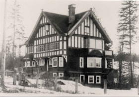
Woodward House
https://search.heritageburnaby.ca/link/landmark500
- Repository
- Burnaby Heritage Planning
- Description
- The Woodward House is a two-storey plus basement, wood-framed house with British Arts and Crafts influences. It is set in a wooded landscape on a lakefront property, on Sperling Avenue within the Deer Lake Park Heritage Precinct of Burnaby, with expansive views of the lake.
- Associated Dates
- 1912
- Formal Recognition
- Community Heritage Register
- Other Names
- Maud & Harriet Woodward Residence
- Street View URL
- Google Maps Street View
- Repository
- Burnaby Heritage Planning
- Other Names
- Maud & Harriet Woodward Residence
- Geographic Access
- Sperling Avenue
- Associated Dates
- 1912
- Formal Recognition
- Community Heritage Register
- Enactment Type
- Council Resolution
- Enactment Date
- 26/05/2003
- Description
- The Woodward House is a two-storey plus basement, wood-framed house with British Arts and Crafts influences. It is set in a wooded landscape on a lakefront property, on Sperling Avenue within the Deer Lake Park Heritage Precinct of Burnaby, with expansive views of the lake.
- Heritage Value
- Maud Sarah Woodward (1865-1958), a pioneer nurse originally from England, and her sister Harriet Julia Woodward (1879-1969), one of Burnaby’s first teachers, had this large house built in 1912 to replace the smaller cottage they owned nearby at 5141 Sperling Avenue. Farmer, builder and longtime Deer Lake resident, Bernard R. Hill (1858-1939), was hired as the contractor. The Woodward House played an important role in the Deer Lake community. The Woodward sisters were tireless community organizers and volunteers. This house served a number of functions, and in addition to being the sisters’ home was the local post office until 1949 and also a private kindergarten/school until 1935. Originally designed in the British Arts and Crafts style with a simple rustic exterior of cedar shingles, it is an excellent example of the type of residence constructed by middle-class citizens in the Deer Lake neighbourhood. The B.C. Electric Railway's Burnaby Lake Interurban line, which opened June 12, 1911, fostered the development of Deer Lake as well as other Edwardian era neighbourhoods in Burnaby.
- Defining Elements
- Key elements that define the heritage character of the Woodward House include its: - lakefront location, within the Deer Lake Park Heritage Precinct - residential form, scale and massing as exhibited by its two-storey height, full basement, square floor plan and side-gabled roof - internal red-brick chimneys - British Arts and Crafts features such as cedar shingle siding, extant under later plywood - associated landscape features such as mature coniferous trees
- Historic Neighbourhood
- Burnaby Lake (Historic Neighbourhood)
- Planning Study Area
- Morley-Buckingham Area
- Builder
- Bernard R. Hill
- Function
- Primary Historic--Single Dwelling
- Primary Current--Single Dwelling
- Community
- Deer Lake
- Cadastral Identifier
- P.I.D.002-507-064
- Boundaries
- The Woodward House is comprised of a single residential lot located at 5195 Sperling Avenue, Burnaby.
- Area
- 1788.5
- Contributing Resource
- Building
- Ownership
- Public (local)
- Documentation
- City of Burnaby Planning and Building Department, Heritage Site Files
- Street Address
- 5195 Sperling Avenue
- Street View URL
- Google Maps Street View
Images


![Ambulance workers at a car accident, [2000] thumbnail](/media/hpo/_Data/_Archives_Images/_Unrestricted/535/535-2551.jpg?width=280)
Ambulance workers at a car accident
https://search.heritageburnaby.ca/link/archivedescription97019
- Repository
- City of Burnaby Archives
- Date
- [2000]
- Collection/Fonds
- Burnaby NewsLeader photograph collection
- Description Level
- Item
- Physical Description
- 1 photograph (tiff) : col.
- Scope and Content
- Photograph of two unidentified ambulance workers tending to the unidentified occupants of a car involved in a three-vehicle accident on Kingsway by Sperling.
- Repository
- City of Burnaby Archives
- Date
- [2000]
- Collection/Fonds
- Burnaby NewsLeader photograph collection
- Physical Description
- 1 photograph (tiff) : col.
- Description Level
- Item
- Record No.
- 535-2551
- Access Restriction
- No restrictions
- Reproduction Restriction
- No restrictions
- Accession Number
- 2018-12
- Scope and Content
- Photograph of two unidentified ambulance workers tending to the unidentified occupants of a car involved in a three-vehicle accident on Kingsway by Sperling.
- Media Type
- Photograph
- Photographer
- Bartel, Mario
- Notes
- Title based on caption
- Collected by editorial for use in a July 2000 issue of the Burnaby NewsLeader
- Caption from metadata: "Emergency workers tend to two injured occupants in a small pick-up truck, the middle vehicle in a three-vehicle accident during Wednesday's rush hour, on Kingsway, just west of Sperling."
- Geographic Access
- Kingsway
- Sperling Avenue
- Historic Neighbourhood
- Edmonds (Historic Neighbourhood)
- Planning Study Area
- Kingsway-Beresford Area
Images
![Ambulance workers at a car accident, [2000] thumbnail](/media/hpo/_Data/_Archives_Images/_Unrestricted/535/535-2551.jpg)
![Brantford Elementary school crosswalk, [2004] thumbnail](/media/hpo/_Data/_Archives_Images/_Unrestricted/535/535-2054.jpg?width=280)
Brantford Elementary school crosswalk
https://search.heritageburnaby.ca/link/archivedescription96384
- Repository
- City of Burnaby Archives
- Date
- [2004]
- Collection/Fonds
- Burnaby NewsLeader photograph collection
- Description Level
- Item
- Physical Description
- 1 photograph (tiff) : col.
- Scope and Content
- Photograph of Ernie Kashima, the principal of Brantford Elementary School, standing at a school crosswalk at Sperling Avenue near the elementary school.
- Repository
- City of Burnaby Archives
- Date
- [2004]
- Collection/Fonds
- Burnaby NewsLeader photograph collection
- Physical Description
- 1 photograph (tiff) : col.
- Description Level
- Item
- Record No.
- 535-2054
- Access Restriction
- No restrictions
- Reproduction Restriction
- No restrictions
- Accession Number
- 2018-12
- Scope and Content
- Photograph of Ernie Kashima, the principal of Brantford Elementary School, standing at a school crosswalk at Sperling Avenue near the elementary school.
- Media Type
- Photograph
- Photographer
- Bartel, Mario
- Notes
- Title based on caption
- Collected by editorial for use in a March 2004 issue of the Burnaby NewsLeader
- Caption from metadata: "Ernie Kashima, the principal of Brantford Elementary School, says he pulled his school's student crossing guards from a crossing on Sperling Ave. because of fears for the guards' safety, as the street doesn't have a school speed zone."
- Geographic Access
- Sperling Avenue
- Brantford Avenue
- Street Address
- 6512 Brantford Avenue
- Historic Neighbourhood
- Edmonds (Historic Neighbourhood)
- Planning Study Area
- Kingsway-Beresford Area
Images
![Brantford Elementary school crosswalk, [2004] thumbnail](/media/hpo/_Data/_Archives_Images/_Unrestricted/535/535-2054.jpg)
![Burnaby Lake Store, [1911] (date of original), copied ca. 2004 thumbnail](/media/hpo/_Data/_Archives_Images/_Unrestricted/371/475-001.jpg?width=280)
Burnaby Lake Store
https://search.heritageburnaby.ca/link/archivedescription38657
- Repository
- City of Burnaby Archives
- Date
- [1911] (date of original), copied ca. 2004
- Collection/Fonds
- Burnaby Historical Society fonds
- Description Level
- Item
- Physical Description
- 1 photograph : sepia ; 21 x 26 cm print
- Scope and Content
- Photograph of two unidentified men standing outside the Burnaby Lake Store on Douglas Road and Sperling Avenue (old street naming system, this portion of Douglas Road is now Canada Way).
- Repository
- City of Burnaby Archives
- Date
- [1911] (date of original), copied ca. 2004
- Collection/Fonds
- Burnaby Historical Society fonds
- Subseries
- Photographs subseries
- Physical Description
- 1 photograph : sepia ; 21 x 26 cm print
- Description Level
- Item
- Record No.
- 475-001
- Access Restriction
- No restrictions
- Reproduction Restriction
- No known restrictions
- Accession Number
- BHS2005-7
- Scope and Content
- Photograph of two unidentified men standing outside the Burnaby Lake Store on Douglas Road and Sperling Avenue (old street naming system, this portion of Douglas Road is now Canada Way).
- Names
- Burnaby Lake Store
- Media Type
- Photograph
- Notes
- Title based on contents of photograph
- Geographic Access
- Douglas Road
- Canada Way
- Sperling Avenue
- Historic Neighbourhood
- Burnaby Lake (Historic Neighbourhood)
- Planning Study Area
- Morley-Buckingham Area
Images
![Burnaby Lake Store, [1911] (date of original), copied ca. 2004 thumbnail](/media/hpo/_Data/_Archives_Images/_Unrestricted/371/475-001.jpg)
![Car crash at Imperial and Sperling, [2000] thumbnail](/media/hpo/_Data/_Archives_Images/_Unrestricted/535/535-2395.jpg?width=280)
Car crash at Imperial and Sperling
https://search.heritageburnaby.ca/link/archivedescription96837
- Repository
- City of Burnaby Archives
- Date
- [2000]
- Collection/Fonds
- Burnaby NewsLeader photograph collection
- Description Level
- Item
- Physical Description
- 1 photograph (tiff) : col.
- Scope and Content
- Photograph of the an investigator taking measurements following a two-vehicle collision at Imperial and Sperling, where a truck crashed into a home and killed a pedestrian. The crashed truck is visible behind the investigator.
- Repository
- City of Burnaby Archives
- Date
- [2000]
- Collection/Fonds
- Burnaby NewsLeader photograph collection
- Physical Description
- 1 photograph (tiff) : col.
- Description Level
- Item
- Record No.
- 535-2395
- Access Restriction
- No restrictions
- Reproduction Restriction
- No restrictions
- Accession Number
- 2018-12
- Scope and Content
- Photograph of the an investigator taking measurements following a two-vehicle collision at Imperial and Sperling, where a truck crashed into a home and killed a pedestrian. The crashed truck is visible behind the investigator.
- Subjects
- Accidents - Automobile Accidents
- Media Type
- Photograph
- Photographer
- Bartel, Mario
- Notes
- Title based on caption
- Collected by editorial for use in a May 2000 issue of the Burnaby NewsLeader
- Caption from metadata: "An accident investigator takes measurements after a two vehicle collision at Imperial and Sperling sent a pick-up truck crashing into a house at the corner, killing a pedestrian who had just left the house, and injuring two occupants in the basement suite."
- Geographic Access
- Imperial Street
- Sperling Avenue
- Historic Neighbourhood
- Edmonds (Historic Neighbourhood)
- Planning Study Area
- Kingsway-Beresford Area
Images
![Car crash at Imperial and Sperling, [2000] thumbnail](/media/hpo/_Data/_Archives_Images/_Unrestricted/535/535-2395.jpg)
![Christmas tree bonfire at Fire Station #1, [2003] thumbnail](/media/hpo/_Data/_Archives_Images/_Unrestricted/535/535-1805.jpg?width=280)
Christmas tree bonfire at Fire Station #1
https://search.heritageburnaby.ca/link/archivedescription96056
- Repository
- City of Burnaby Archives
- Date
- [2003]
- Collection/Fonds
- Burnaby NewsLeader photograph collection
- Description Level
- Item
- Physical Description
- 1 photograph (tiff) : col.
- Scope and Content
- Photograph of two Burnaby fire fighters watching a tree burn during the Burnaby Fire Department's annual Christmas tree bonfire at Fire Station #1.
- Repository
- City of Burnaby Archives
- Date
- [2003]
- Collection/Fonds
- Burnaby NewsLeader photograph collection
- Physical Description
- 1 photograph (tiff) : col.
- Description Level
- Item
- Record No.
- 535-1805
- Access Restriction
- No restrictions
- Reproduction Restriction
- No restrictions
- Accession Number
- 2018-12
- Scope and Content
- Photograph of two Burnaby fire fighters watching a tree burn during the Burnaby Fire Department's annual Christmas tree bonfire at Fire Station #1.
- Names
- Burnaby Fire Department
- Media Type
- Photograph
- Photographer
- Bartel, Mario
- Notes
- Title based on caption
- Collected by editorial for use in a January 2003 issue of the Burnaby NewsLeader
- Caption from metadata: "Captain Ward Rossiter and Paul Rushton, of the Burnaby Fire Department, admire their handiwork at the department's annual bonfire of discarded Christmas trees, at Firehall No. 1. While firefighters are more accustomed to extinguishing fires than setting them, the event raises money for the burn unit at Children's Hospital, as well as awareness about the importance of keeping the trees well-watered."
- Geographic Access
- Sperling Avenue
- Street Address
- 4867 Sperling Avenue
- Historic Neighbourhood
- Burnaby Lake (Historic Neighbourhood)
- Planning Study Area
- Morley-Buckingham Area
Images
![Christmas tree bonfire at Fire Station #1, [2003] thumbnail](/media/hpo/_Data/_Archives_Images/_Unrestricted/535/535-1805.jpg)

Claude and Kitty on a footbridge
https://search.heritageburnaby.ca/link/archivedescription39558
- Repository
- City of Burnaby Archives
- Date
- 1910
- Collection/Fonds
- Peers Family and Hill Family fonds
- Description Level
- Item
- Physical Description
- 1 photograph : b&w ; 7.5 x 10 cm on page 21.5 x 28 cm (pasted in album)
- Scope and Content
- Photograph of Claude Hill with his daughter Kitty standing on a foot bridge over a small creek. In the background directly behind Kitty can be seen the Hill family home known as Broadview which was located on Buckingham Avenue. The Pole Line Road (later renamed Sperling Avenue) can also be seen. …
- Repository
- City of Burnaby Archives
- Date
- 1910
- Collection/Fonds
- Peers Family and Hill Family fonds
- Physical Description
- 1 photograph : b&w ; 7.5 x 10 cm on page 21.5 x 28 cm (pasted in album)
- Description Level
- Item
- Record No.
- 477-877
- Access Restriction
- No restrictions
- Reproduction Restriction
- No known restrictions
- Accession Number
- 2007-12
- Scope and Content
- Photograph of Claude Hill with his daughter Kitty standing on a foot bridge over a small creek. In the background directly behind Kitty can be seen the Hill family home known as Broadview which was located on Buckingham Avenue. The Pole Line Road (later renamed Sperling Avenue) can also be seen. At the far left, top corner of the photograph another house is visible. This was the home of Francis J. Peers, on what is now Rugby Avenue (5289 Rugby). This house was known as Greyfriars. Kitty Hill would later marry Bob Peers, son of Francis.
- Subjects
- Structures - Bridges
- Media Type
- Photograph
- Notes
- Title based on contents of photograph
- Geographic Access
- Buckingham Avenue
- Sperling Avenue
- Street Address
- 5730 Buckingham Avenue
- Historic Neighbourhood
- Burnaby Lake (Historic Neighbourhood)
- Planning Study Area
- Morley-Buckingham Area
Images

![Down Syndrome Research Foundation Resource Centre, [2002] thumbnail](/media/hpo/_Data/_Archives_Images/_Unrestricted/535/535-1976-4.jpg?width=280)
Down Syndrome Research Foundation Resource Centre
https://search.heritageburnaby.ca/link/archivedescription96293
- Repository
- City of Burnaby Archives
- Date
- [2002]
- Collection/Fonds
- Burnaby NewsLeader photograph collection
- Description Level
- File
- Physical Description
- 4 photographs (tiff) : col.
- Scope and Content
- File contains photographs of the new Down Syndrome Research Foundation resource centre in North Burnaby. Photographs depict one of the children who visit the foundation, Aliya Dall'Antonia, with her family at the centre; Director of Communications and Marketing Dana Gallagher with her dog outside o…
- Repository
- City of Burnaby Archives
- Date
- [2002]
- Collection/Fonds
- Burnaby NewsLeader photograph collection
- Physical Description
- 4 photographs (tiff) : col.
- Description Level
- File
- Record No.
- 535-1976
- Access Restriction
- No restrictions
- Reproduction Restriction
- No restrictions
- Accession Number
- 2018-12
- Scope and Content
- File contains photographs of the new Down Syndrome Research Foundation resource centre in North Burnaby. Photographs depict one of the children who visit the foundation, Aliya Dall'Antonia, with her family at the centre; Director of Communications and Marketing Dana Gallagher with her dog outside of the centre; and Executive Director Josephine Mills in the atrium of the resource centre.
- Subjects
- Public Services - Health Services
- Media Type
- Photograph
- Photographer
- Bartel, Mario
- Notes
- Title based on caption
- Collected by editorial for use in a February 2002 issue of the Burnaby NewsLeader
- Caption from metadata for 535-1976-1: "Aliya Dall'Antonia, 4, a Downs Syndrome child, enjoys a moment with her mom, Adrienne. Aliya and her family will soon be able to get the resources to meet her special needs at the new Downs Syndrome Research Foundation in North Burnaby."
- Caption from metadata for 535-1976-2: "Aliya Dall'Antonia, 4, builds puzzles with her sister, Lianna, 3, as their parents, Adrienne and Roger look on. The Dall'Antonia family will soon be able to access the resources they need for Aliya's special needs at the new Downs Syndrome Research Foundation in North Burnaby."
- Caption from metadata for 535-1976-3: "Dana Gallagher, the Director of Communications and Marketing at the new Downs Syndrome Research Foundation, brings her dog, Zulu, to work to help put children at ease when they visit their new Resource Centre in North Burnaby."
- Caption from metadata for 535-1976-4: "Josephine Mills, Executive Director of the Down Syndrome Research Foundation, in the atrium of their new Resource Centre in North Burnaby. The lounge is also a meeting area for parents of downs children."
- Geographic Access
- Sperling Avenue
- Street Address
- 1409 Sperling Avenue
- Historic Neighbourhood
- Lochdale (Historic Neighbourhood)
- Planning Study Area
- Lochdale Area
Images
![Down Syndrome Research Foundation Resource Centre, [2002] thumbnail](/media/hpo/_Data/_Archives_Images/_Unrestricted/535/535-1976-4.jpg)
![Down Syndrome Research Foundation Resource Centre, [2001] thumbnail](/media/hpo/_Data/_Archives_Images/_Unrestricted/535/535-2211.jpg?width=280)
Down Syndrome Research Foundation Resource Centre
https://search.heritageburnaby.ca/link/archivedescription96589
- Repository
- City of Burnaby Archives
- Date
- [2001]
- Collection/Fonds
- Burnaby NewsLeader photograph collection
- Description Level
- Item
- Physical Description
- 1 photograph (tiff) : col.
- Scope and Content
- Photograph of Dana Gallagher, communications coordinator, and Josephine Mills, executive director, at the site of the under-construction Down Syndrome Research Foundation Resource Centre in North Burnaby. Mills and Gallagher hold open a plan for the Centre and a construction vehicle is visible behi…
- Repository
- City of Burnaby Archives
- Date
- [2001]
- Collection/Fonds
- Burnaby NewsLeader photograph collection
- Physical Description
- 1 photograph (tiff) : col.
- Description Level
- Item
- Record No.
- 535-2211
- Access Restriction
- No restrictions
- Reproduction Restriction
- No restrictions
- Accession Number
- 2018-12
- Scope and Content
- Photograph of Dana Gallagher, communications coordinator, and Josephine Mills, executive director, at the site of the under-construction Down Syndrome Research Foundation Resource Centre in North Burnaby. Mills and Gallagher hold open a plan for the Centre and a construction vehicle is visible behind them.
- Media Type
- Photograph
- Photographer
- Bartel, Mario
- Notes
- Title based on caption
- Collected by editorial for use in a March 2001 issue of the Burnaby NewsLeader
- Caption from metadata: "Dana Gallagher, the communications co-ordinator, and Josephine Mills, the executive director, discuss plans for the Downs Syndrome Research Centre which is about to be constructed in North Burnaby."
- Geographic Access
- Sperling Avenue
- Street Address
- 1409 Sperling Avenue
- Historic Neighbourhood
- Lochdale (Historic Neighbourhood)
- Planning Study Area
- Lochdale Area
Images
![Down Syndrome Research Foundation Resource Centre, [2001] thumbnail](/media/hpo/_Data/_Archives_Images/_Unrestricted/535/535-2211.jpg)
![Down Syndrome Research Foundation Resource Centre lot, [2000] thumbnail](/media/hpo/_Data/_Archives_Images/_Unrestricted/535/535-2110.jpg?width=280)
Down Syndrome Research Foundation Resource Centre lot
https://search.heritageburnaby.ca/link/archivedescription96486
- Repository
- City of Burnaby Archives
- Date
- [2000]
- Collection/Fonds
- Burnaby NewsLeader photograph collection
- Description Level
- Item
- Physical Description
- 1 photograph (tiff) : col.
- Scope and Content
- Photograph of Josephine Mills standing with her hand on a fence. Behind Mills is an empty lot on Sperling Avenue that will become the Down Syndrome Research Foundation Resource Centre.
- Repository
- City of Burnaby Archives
- Date
- [2000]
- Collection/Fonds
- Burnaby NewsLeader photograph collection
- Physical Description
- 1 photograph (tiff) : col.
- Description Level
- Item
- Record No.
- 535-2110
- Access Restriction
- No restrictions
- Reproduction Restriction
- No restrictions
- Accession Number
- 2018-12
- Scope and Content
- Photograph of Josephine Mills standing with her hand on a fence. Behind Mills is an empty lot on Sperling Avenue that will become the Down Syndrome Research Foundation Resource Centre.
- Subjects
- Public Services - Health Services
- Media Type
- Photograph
- Photographer
- Bartel, Mario
- Notes
- Title based on caption
- Collected by editorial for use in a March 2000 issue of the Burnaby NewsLeader
- Caption from metadata: "Josephine Mills inspects the empty lot on Sperling Ave. that will soon become the home of BC's first Downs Syndrome Resource Centre."
- Geographic Access
- Sperling Avenue
- Street Address
- 1409 Sperling Avenue
- Historic Neighbourhood
- Lochdale (Historic Neighbourhood)
- Planning Study Area
- Lochdale Area
Images
![Down Syndrome Research Foundation Resource Centre lot, [2000] thumbnail](/media/hpo/_Data/_Archives_Images/_Unrestricted/535/535-2110.jpg)
![Down Syndrome Research Foundation Resource Centre opening, [2002] thumbnail](/media/hpo/_Data/_Archives_Images/_Unrestricted/535/535-2323.jpg?width=280)
Down Syndrome Research Foundation Resource Centre opening
https://search.heritageburnaby.ca/link/archivedescription96718
- Repository
- City of Burnaby Archives
- Date
- [2002]
- Collection/Fonds
- Burnaby NewsLeader photograph collection
- Description Level
- Item
- Physical Description
- 1 photograph (tiff) : col.
- Scope and Content
- Photograph of Gordon Hogg, the Minister of Children and Family Development, with two children, Sadie Gates and Lisa Forman, at the ribbon-cutting ceremony to open the new Down Syndrome Research Foundation Resource Centre.
- Repository
- City of Burnaby Archives
- Date
- [2002]
- Collection/Fonds
- Burnaby NewsLeader photograph collection
- Physical Description
- 1 photograph (tiff) : col.
- Description Level
- Item
- Record No.
- 535-2323
- Access Restriction
- No restrictions
- Reproduction Restriction
- No restrictions
- Accession Number
- 2018-12
- Scope and Content
- Photograph of Gordon Hogg, the Minister of Children and Family Development, with two children, Sadie Gates and Lisa Forman, at the ribbon-cutting ceremony to open the new Down Syndrome Research Foundation Resource Centre.
- Media Type
- Photograph
- Photographer
- Bartel, Mario
- Notes
- Title based on caption
- Collected by editorial for use in an April 2002 issue of the Burnaby NewsLeader
- Caption from metadata: "Sadie Gates (L), Gordon Hogg, the Minister of Children and Family Development, and Lisa Forman, cut the ribbon to officially open the new Down Syndrom Research Foundation, in North Burnaby."
- Geographic Access
- Sperling Avenue
- Street Address
- 1409 Sperling Avenue
- Historic Neighbourhood
- Lochdale (Historic Neighbourhood)
- Planning Study Area
- Lochdale Area
Images
![Down Syndrome Research Foundation Resource Centre opening, [2002] thumbnail](/media/hpo/_Data/_Archives_Images/_Unrestricted/535/535-2323.jpg)
![Edith Clayton Outside Burnaby Lake Store, [1913] thumbnail](/media/hpo/_Data/_Archives_Images/_Unrestricted/477/477-201.jpg?width=280)
Edith Clayton Outside Burnaby Lake Store
https://search.heritageburnaby.ca/link/archivedescription38882
- Repository
- City of Burnaby Archives
- Date
- [1913]
- Collection/Fonds
- Peers Family and Hill Family fonds
- Description Level
- Item
- Physical Description
- 1 photograph : sepia ; 8.2 x 12.5 cm on page 14 x 17.5 cm (pasted in album)
- Scope and Content
- Photograph of Edith Clayton standing on the boarded sidewalk outside the Burnaby Lake Store. The photograph was taken looking along Douglas Road (later, Canada Way), towards New Westminster. Edith is dressed in a winter coat with scarf, mittens and hat.
- Repository
- City of Burnaby Archives
- Date
- [1913]
- Collection/Fonds
- Peers Family and Hill Family fonds
- Physical Description
- 1 photograph : sepia ; 8.2 x 12.5 cm on page 14 x 17.5 cm (pasted in album)
- Description Level
- Item
- Record No.
- 477-201
- Access Restriction
- No restrictions
- Reproduction Restriction
- No known restrictions
- Accession Number
- 2007-12
- Scope and Content
- Photograph of Edith Clayton standing on the boarded sidewalk outside the Burnaby Lake Store. The photograph was taken looking along Douglas Road (later, Canada Way), towards New Westminster. Edith is dressed in a winter coat with scarf, mittens and hat.
- Media Type
- Photograph
- Notes
- Title based on caption accompanying photograph
- Geographic Access
- Sperling Avenue
- Douglas Road
- Canada Way
- Historic Neighbourhood
- Burnaby Lake (Historic Neighbourhood)
- Planning Study Area
- Morley-Buckingham Area
Images
![Edith Clayton Outside Burnaby Lake Store, [1913] thumbnail](/media/hpo/_Data/_Archives_Images/_Unrestricted/477/477-201.jpg)
![Fire fighters' annual tree chip and burn, [2004] thumbnail](/media/hpo/_Data/_Archives_Images/_Unrestricted/535/535-1737-1.jpg?width=280)
Fire fighters' annual tree chip and burn
https://search.heritageburnaby.ca/link/archivedescription95986
- Repository
- City of Burnaby Archives
- Date
- [2004]
- Collection/Fonds
- Burnaby NewsLeader photograph collection
- Description Level
- File
- Physical Description
- 2 photographs (tiff) : col.
- Scope and Content
- File contains photographs of fire fighters working the Burnaby Fire Department's annual Christmas tree chip and burn at Burnaby Fire Station #1. Photographs show fire fighters warming their hands and watching as a pile of scrap wood and trees burn.
- Repository
- City of Burnaby Archives
- Date
- [2004]
- Collection/Fonds
- Burnaby NewsLeader photograph collection
- Physical Description
- 2 photographs (tiff) : col.
- Description Level
- File
- Record No.
- 535-1737
- Access Restriction
- No restrictions
- Reproduction Restriction
- No restrictions
- Accession Number
- 2018-12
- Scope and Content
- File contains photographs of fire fighters working the Burnaby Fire Department's annual Christmas tree chip and burn at Burnaby Fire Station #1. Photographs show fire fighters warming their hands and watching as a pile of scrap wood and trees burn.
- Names
- Burnaby Fire Department
- Media Type
- Photograph
- Photographer
- Bartel, Mario
- Notes
- Title based on caption
- Collected by editorial for use in a January 2004 issue of the Burnaby NewsLeader
- Caption from metadata for 535-1737-1: "Russ Flasch and Joe Tyler warm their hands at the Burnaby Firefighters' annual Christmas tree chip and burn, Saturday at Fire Hall No. 1."
- Caption from metadata for 535-1737-2: "Shaun Redmond keeps a close eye on the bonfire at the Burnaby Firefighters' annual Christmas tree chip and burn, Saturday at Fire Hall No. 1."
- Geographic Access
- Sperling Avenue
- Street Address
- 4867 Sperling Avenue
- Historic Neighbourhood
- Burnaby Lake (Historic Neighbourhood)
- Planning Study Area
- Morley-Buckingham Area
Images
![Fire fighters' annual tree chip and burn, [2004] thumbnail](/media/hpo/_Data/_Archives_Images/_Unrestricted/535/535-1737-1.jpg)
![Fire fighters' annual tree chip and burn, [2005] thumbnail](/media/hpo/_Data/_Archives_Images/_Unrestricted/535/535-1850.jpg?width=280)
Fire fighters' annual tree chip and burn
https://search.heritageburnaby.ca/link/archivedescription96153
- Repository
- City of Burnaby Archives
- Date
- [2005]
- Collection/Fonds
- Burnaby NewsLeader photograph collection
- Description Level
- Item
- Physical Description
- 1 photograph (tiff) : col.
- Scope and Content
- Photograph of Nav Sekhon, a Burnaby fire fighter, watching a bonfire of Christmas trees and wooden pallets during the Burnaby Fire Department's annual Burn and Chip fundraising event at Fire Hall #1. Sekhon is mostly in uniform and the woods in the background are covered in snow.
- Repository
- City of Burnaby Archives
- Date
- [2005]
- Collection/Fonds
- Burnaby NewsLeader photograph collection
- Physical Description
- 1 photograph (tiff) : col.
- Description Level
- Item
- Record No.
- 535-1850
- Access Restriction
- No restrictions
- Reproduction Restriction
- No restrictions
- Accession Number
- 2018-12
- Scope and Content
- Photograph of Nav Sekhon, a Burnaby fire fighter, watching a bonfire of Christmas trees and wooden pallets during the Burnaby Fire Department's annual Burn and Chip fundraising event at Fire Hall #1. Sekhon is mostly in uniform and the woods in the background are covered in snow.
- Names
- Burnaby Fire Department
- Media Type
- Photograph
- Photographer
- Bartel, Mario
- Notes
- Title based on caption
- Collected by editorial for use in a January 2005 issue of the Burnaby NewsLeader
- Caption from metadata: "Burnaby firefighter Nav Sekhon supervises the burning of old Christmas trees at the department's annual Burn and Chip event, Saturday at Firehall #1. The fire department burns the trees to demonstrate the flammability of dry trees. Proceeds from the even go to the Firefighters Burn Fund and to the Edmonds Youth Resource Centre."
- Geographic Access
- Sperling Avenue
- Street Address
- 4867 Sperling Avenue
- Historic Neighbourhood
- Burnaby Lake (Historic Neighbourhood)
- Planning Study Area
- Morley-Buckingham Area
Images
![Fire fighters' annual tree chip and burn, [2005] thumbnail](/media/hpo/_Data/_Archives_Images/_Unrestricted/535/535-1850.jpg)
![Gavin House, [after 1911] thumbnail](/media/hpo/_Data/_Archives_Images/_Unrestricted/205/241-031.jpg?width=280)
Gavin House
https://search.heritageburnaby.ca/link/archivedescription51363
- Repository
- City of Burnaby Archives
- Date
- [after 1911]
- Collection/Fonds
- Burnaby Historical Society fonds
- Description Level
- Item
- Physical Description
- 1 photograph : b&w copy negative ; 2 x 3.5 cm
- Scope and Content
- Photograph of the Gavin House taken from a distance at a 3/4 view. Fence posts are visible. This home was designed by architect A. C. Hope.
- Repository
- City of Burnaby Archives
- Date
- [after 1911]
- Collection/Fonds
- Burnaby Historical Society fonds
- Subseries
- Burnaby Art Gallery subseries
- Physical Description
- 1 photograph : b&w copy negative ; 2 x 3.5 cm
- Description Level
- Item
- Record No.
- 241-031
- Access Restriction
- No restrictions
- Reproduction Restriction
- No known restrictions
- Accession Number
- BHS1990-05
- Scope and Content
- Photograph of the Gavin House taken from a distance at a 3/4 view. Fence posts are visible. This home was designed by architect A. C. Hope.
- Subjects
- Buildings - Residential - Houses
- Media Type
- Photograph
- Notes
- Title based on contents of photograph
- Geographic Access
- Buckingham Avenue
- Sperling Avenue
- Historic Neighbourhood
- Burnaby Lake (Historic Neighbourhood)
- Planning Study Area
- Sperling-Broadway Area
Images
![Gavin House, [after 1911] thumbnail](/media/hpo/_Data/_Archives_Images/_Unrestricted/205/241-031.jpg)
Gavin house
https://search.heritageburnaby.ca/link/archivedescription36002
- Repository
- City of Burnaby Archives
- Date
- 1912
- Collection/Fonds
- Burnaby Historical Society fonds
- Description Level
- Item
- Physical Description
- 1 photograph : b&w ; 8.5 x 12.5 cm print
- Scope and Content
- Photograph of the Gavin house located on Buckingham Road at Sperling. The house was designed by architect A.C. Hope and built for Francis John Gavin and his family.
- Repository
- City of Burnaby Archives
- Date
- 1912
- Collection/Fonds
- Burnaby Historical Society fonds
- Subseries
- Gavin family subseries
- Physical Description
- 1 photograph : b&w ; 8.5 x 12.5 cm print
- Description Level
- Item
- Record No.
- 209-001
- Access Restriction
- No restrictions
- Reproduction Restriction
- No known restrictions
- Accession Number
- BHS1988-09
- Scope and Content
- Photograph of the Gavin house located on Buckingham Road at Sperling. The house was designed by architect A.C. Hope and built for Francis John Gavin and his family.
- Subjects
- Buildings - Residential - Houses
- Media Type
- Photograph
- Notes
- Title based on contents of photograph
- Geographic Access
- Buckingham Avenue
- Sperling Avenue
- Historic Neighbourhood
- Lochdale (Historic Neighbourhood)
- Planning Study Area
- Sperling-Broadway Area
Images

![Hill farm, [1915] thumbnail](/media/hpo/_Data/_Archives_Images/_Unrestricted/477/477-653.jpg?width=280)
Hill farm
https://search.heritageburnaby.ca/link/archivedescription39334
- Repository
- City of Burnaby Archives
- Date
- [1915]
- Collection/Fonds
- Peers Family and Hill Family fonds
- Description Level
- Item
- Physical Description
- 2 photographs : b&w ; 5 x 10.5 cm on page 24.5 x 32.5 cm (pasted in album and joined to form one panorama)
- Scope and Content
- Photograph of the Hill family farm near Deer Lake. The panorama shows the buildings and fields and off to the right can be seen the Pole Line Road (Sperling Avenue).
- Repository
- City of Burnaby Archives
- Date
- [1915]
- Collection/Fonds
- Peers Family and Hill Family fonds
- Physical Description
- 2 photographs : b&w ; 5 x 10.5 cm on page 24.5 x 32.5 cm (pasted in album and joined to form one panorama)
- Description Level
- Item
- Record No.
- 477-653
- Access Restriction
- No restrictions
- Reproduction Restriction
- No known restrictions
- Accession Number
- 2007-12
- Scope and Content
- Photograph of the Hill family farm near Deer Lake. The panorama shows the buildings and fields and off to the right can be seen the Pole Line Road (Sperling Avenue).
- Media Type
- Photograph
- Notes
- Title based on contents of photograph
- Geographic Access
- Sperling Avenue
- Historic Neighbourhood
- Burnaby Lake (Historic Neighbourhood)
- Planning Study Area
- Morley-Buckingham Area
Images
![Hill farm, [1915] thumbnail](/media/hpo/_Data/_Archives_Images/_Unrestricted/477/477-653.jpg)
![In front of Duthie School, [between 1911 and 1919] thumbnail](/media/hpo/_Data/_Archives_Images/_Unrestricted/316/325-031.jpg?width=280)
In front of Duthie School
https://search.heritageburnaby.ca/link/archivedescription37159
- Repository
- City of Burnaby Archives
- Date
- [between 1911 and 1919]
- Collection/Fonds
- Burnaby Historical Society fonds
- Description Level
- Item
- Physical Description
- 1 photograph : b&w ; 12.5 x 8 cm print
- Scope and Content
- Photograph of a man with surveyor equipment sitting on the wooden sidewalk in front of Duthie School (also called Johnston Road School). This school existed from 1909 to 1921.
- Repository
- City of Burnaby Archives
- Date
- [between 1911 and 1919]
- Collection/Fonds
- Burnaby Historical Society fonds
- Subseries
- Disney family subseries
- Physical Description
- 1 photograph : b&w ; 12.5 x 8 cm print
- Description Level
- Item
- Record No.
- 325-031
- Access Restriction
- No restrictions
- Reproduction Restriction
- No known restrictions
- Accession Number
- BHS1996-04
- Scope and Content
- Photograph of a man with surveyor equipment sitting on the wooden sidewalk in front of Duthie School (also called Johnston Road School). This school existed from 1909 to 1921.
- Subjects
- Buildings - Schools
- Names
- Duthie School
- Media Type
- Photograph
- Photographer
- Disney, John Harold "Jack"
- Notes
- Title based on contents of photograph
- Geographic Access
- Broadway
- Sperling Avenue
- Historic Neighbourhood
- Lochdale (Historic Neighbourhood)
- Planning Study Area
- Sperling-Broadway Area
Images
![In front of Duthie School, [between 1911 and 1919] thumbnail](/media/hpo/_Data/_Archives_Images/_Unrestricted/316/325-031.jpg)