Narrow Results By
Subject
- Advertising Medium - Signs and Signboards 2
- Animals - Birds 1
- Animals - Dogs 4
- Armament 2
- Arts 1
- Buildings - Agricultural - Stables 1
- Buildings - Commercial - Restaurants 2
- Buildings - Commercial - Stores 1
- Buildings - Heritage 4
- Buildings - Industrial - Mills 3
- Buildings - Recreational 1
- Buildings - Residential 1

Government Docks, New Westminster
https://search.heritageburnaby.ca/link/archivedescription39576
- Repository
- City of Burnaby Archives
- Date
- 1910
- Collection/Fonds
- Peers Family and Hill Family fonds
- Description Level
- Item
- Physical Description
- 1 photograph : b&w ; 7.8 x 10.2 cm on page 21.5 x 28 cm (pasted in album)
- Scope and Content
- Photograph of a boat (the "Vite") pulled up to the Government docks at the foot of 8th Street in New Westminster. Queensborough can be seen in the background. The three men in the boat are unidentified.
- Repository
- City of Burnaby Archives
- Date
- 1910
- Collection/Fonds
- Peers Family and Hill Family fonds
- Physical Description
- 1 photograph : b&w ; 7.8 x 10.2 cm on page 21.5 x 28 cm (pasted in album)
- Description Level
- Item
- Record No.
- 477-895
- Access Restriction
- No restrictions
- Reproduction Restriction
- No known restrictions
- Accession Number
- 2007-12
- Scope and Content
- Photograph of a boat (the "Vite") pulled up to the Government docks at the foot of 8th Street in New Westminster. Queensborough can be seen in the background. The three men in the boat are unidentified.
- Subjects
- Recreational Activities - Boating
- Structures - Piers and Wharves
- Geographic Features - Rivers
- Media Type
- Photograph
- Notes
- Title based on contents of photograph
Images


Government Road
https://search.heritageburnaby.ca/link/archivedescription35567
- Repository
- City of Burnaby Archives
- Date
- 1912 (date of original), copied 1986
- Collection/Fonds
- Burnaby Historical Society fonds
- Description Level
- Item
- Physical Description
- 1 photograph : b&w ; 12.7 x 17.8 cm print
- Scope and Content
- Photograph looking east on Government Road from the Haddon family house. One of the men in the photo is Robert Haddon. The other two people are unidentified. Note the loose gravel roadway and the bridge over Eagle Creek.
- Repository
- City of Burnaby Archives
- Date
- 1912 (date of original), copied 1986
- Collection/Fonds
- Burnaby Historical Society fonds
- Subseries
- Pioneer Tales subseries
- Physical Description
- 1 photograph : b&w ; 12.7 x 17.8 cm print
- Description Level
- Item
- Record No.
- 204-425
- Access Restriction
- No restrictions
- Reproduction Restriction
- No known restrictions
- Accession Number
- BHS1988-03
- Scope and Content
- Photograph looking east on Government Road from the Haddon family house. One of the men in the photo is Robert Haddon. The other two people are unidentified. Note the loose gravel roadway and the bridge over Eagle Creek.
- Names
- Haddon, Robert
- Media Type
- Photograph
- Notes
- Title based on contents of photograph
- Geographic Access
- Eagle Creek
- Government Road
- Historic Neighbourhood
- Lozells (Historic Neighbourhood)
- Planning Study Area
- Government Road Area
Images

![Gray family tent, [1911] (date of original), copied 1986 thumbnail](/media/hpo/_Data/_Archives_Images/_Unrestricted/204/204-377.jpg?width=280)
Gray family tent
https://search.heritageburnaby.ca/link/archivedescription35519
- Repository
- City of Burnaby Archives
- Date
- [1911] (date of original), copied 1986
- Collection/Fonds
- Burnaby Historical Society fonds
- Description Level
- Item
- Physical Description
- 1 photograph : b&w ; 12.7 x 17.8 cm print
- Scope and Content
- Photograph of the Gray family tent on their 4375 Winnifred Street property. (Inside tent) Clamor Gray (father of William Gray). The Grays lived in the tent while their house was being built by Mr. Gray, a carpenter.
- Repository
- City of Burnaby Archives
- Date
- [1911] (date of original), copied 1986
- Collection/Fonds
- Burnaby Historical Society fonds
- Subseries
- Pioneer Tales subseries
- Physical Description
- 1 photograph : b&w ; 12.7 x 17.8 cm print
- Description Level
- Item
- Record No.
- 204-377
- Access Restriction
- No restrictions
- Reproduction Restriction
- No known restrictions
- Accession Number
- BHS1988-03
- Scope and Content
- Photograph of the Gray family tent on their 4375 Winnifred Street property. (Inside tent) Clamor Gray (father of William Gray). The Grays lived in the tent while their house was being built by Mr. Gray, a carpenter.
- Subjects
- Land Clearing
- Structures - Tents
- Names
- Gray, Clamor
- Media Type
- Photograph
- Notes
- Title based on contents of photograph
- Geographic Access
- Winnifred Street
- Street Address
- 4375 Winnifred Street
- Historic Neighbourhood
- Alta-Vista (Historic Neighbourhood)
- Planning Study Area
- Sussex-Nelson Area
Images
![Gray family tent, [1911] (date of original), copied 1986 thumbnail](/media/hpo/_Data/_Archives_Images/_Unrestricted/204/204-377.jpg)
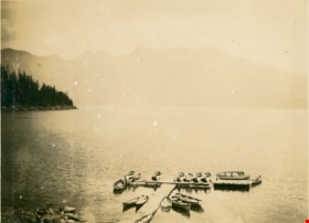
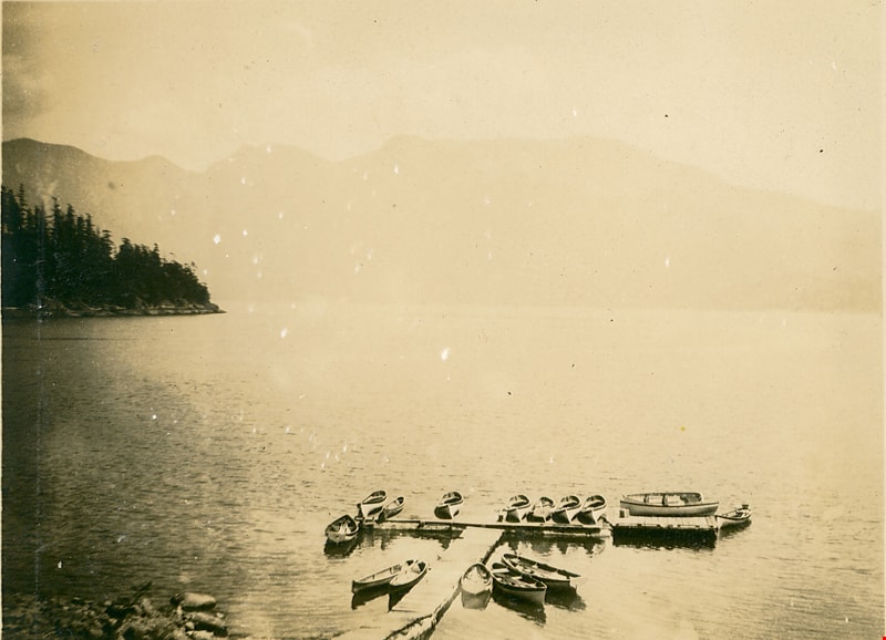
Horseshoe Bay
https://search.heritageburnaby.ca/link/museumdescription1068
- Repository
- Burnaby Village Museum
- Date
- 1910
- Collection/Fonds
- Burnaby Village Museum Photograph collection
- Description Level
- Item
- Physical Description
- 1 photograph : b&w ; 7.5 x 9.9 cm
- Scope and Content
- Photograph of Horeshoe Bay. There are fifteen rowing boats docked at a pier, and mountains are in the background. An annotation on the back of the photograph reads, "Horseshoe Bay / 1910."
- Repository
- Burnaby Village Museum
- Collection/Fonds
- Burnaby Village Museum Photograph collection
- Description Level
- Item
- Physical Description
- 1 photograph : b&w ; 7.5 x 9.9 cm
- Scope and Content
- Photograph of Horeshoe Bay. There are fifteen rowing boats docked at a pier, and mountains are in the background. An annotation on the back of the photograph reads, "Horseshoe Bay / 1910."
- Accession Code
- HV972.50.7
- Access Restriction
- No restrictions
- Reproduction Restriction
- No known restrictions
- Date
- 1910
- Media Type
- Photograph
- Scan Resolution
- 600
- Scan Date
- 2023-04-04
- Photographer
- Dean, H.M.
- Notes
- Title based on contents of photograph
Images
![House at Buena Vista, Burnaby, [between 1912 and 1925] thumbnail](/media/hpo/_Data/_BVM_Images/1984/1984_0051_0029_001.jpg?width=280)
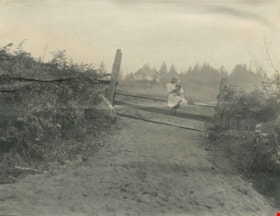
House at Buena Vista, Burnaby
https://search.heritageburnaby.ca/link/museumdescription257
- Repository
- Burnaby Village Museum
- Date
- [between 1912 and 1925]
- Collection/Fonds
- Burnaby Village Museum Photograph collection
- Description Level
- Item
- Physical Description
- 1 photograph : b&w ; 7.0 x 9.0 cm
- Scope and Content
- Photograph of a house with a large porch and a log fence with a gateway in the centre. There is a cobblestone pathway leading to the porch. According to the accession register, the location of the house is at Buena Vista, Burnaby, between 1912 and 1925.
- Repository
- Burnaby Village Museum
- Collection/Fonds
- Burnaby Village Museum Photograph collection
- Description Level
- Item
- Physical Description
- 1 photograph : b&w ; 7.0 x 9.0 cm
- Scope and Content
- Photograph of a house with a large porch and a log fence with a gateway in the centre. There is a cobblestone pathway leading to the porch. According to the accession register, the location of the house is at Buena Vista, Burnaby, between 1912 and 1925.
- Accession Code
- HV984.51.29
- Access Restriction
- No restrictions
- Reproduction Restriction
- No known restrictions
- Date
- [between 1912 and 1925]
- Media Type
- Photograph
- Historic Neighbourhood
- East Burnaby (Historic Neighbourhood)
- Planning Study Area
- Cariboo-Armstrong Area
- Related Material
- To see another photograph of the house, see HV984.51.17 and .19
- Scan Resolution
- 600
- Scan Date
- 2023-10-10
- Notes
- Title based on contents of photograph
Images
![House at Buena Vista, Burnaby, [between 1912 and 1925] thumbnail](/media/hpo/_Data/_BVM_Images/1984/1984_0051_0029_001.jpg)
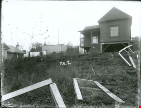
House with a broken wire fence
https://search.heritageburnaby.ca/link/museumdescription3079
- Repository
- Burnaby Village Museum
- Date
- [between 1900 and 1910
- Collection/Fonds
- Burnaby Village Museum Photograph collection
- Description Level
- Item
- Physical Description
- 1 photograph : b&w glass negative
- Scope and Content
- Photograph of an unidentified house with a broken wire fence in its front lawn. There are a couple of houses seen nearby the house and power poles running along a road behind the houses.
- Repository
- Burnaby Village Museum
- Collection/Fonds
- Burnaby Village Museum Photograph collection
- Description Level
- Item
- Physical Description
- 1 photograph : b&w glass negative
- Material Details
- inscribed in the negative, printed on the photograph, c. "no.2"
- Scope and Content
- Photograph of an unidentified house with a broken wire fence in its front lawn. There are a couple of houses seen nearby the house and power poles running along a road behind the houses.
- Accession Code
- HV973.110.10
- Access Restriction
- No restrictions
- Reproduction Restriction
- No known restrictions
- Date
- [between 1900 and 1910
- Media Type
- Photograph
- Scan Resolution
- 300
- Scan Date
- 16/8/2006
- Scale
- 100
- Notes
- Title based on contents of photograph
- 1 b&w contact print accompanying negative
Images


Interview with Judy Hagen by Eric Damer November 7, 2012 - Track 6
https://search.heritageburnaby.ca/link/oralhistory337
- Repository
- City of Burnaby Archives
- Date Range
- 1944-2012
- Length
- 0:12:18
- Summary
- This portion of the recording pertains to Judith "Judy" (Robins) Hagen's memories of taking dance lessons and being in Girl Guides. She tells a story of seeing the Second Narrows Bridge collapse in 1958.
- Repository
- City of Burnaby Archives
- Summary
- This portion of the recording pertains to Judith "Judy" (Robins) Hagen's memories of taking dance lessons and being in Girl Guides. She tells a story of seeing the Second Narrows Bridge collapse in 1958.
- Date Range
- 1944-2012
- Photo Info
- Judith "Judy" Robins (later Hagen) posing in a dance costume, 1949. Item no. 549-036.
- Length
- 0:12:18
- Interviewer
- Damer, Eric
- Interview Date
- November 7, 2012
- Scope and Content
- Recording is an interview with Judith "Judy" (Robins) Hagen conducted by Burnaby Village Museum employee Eric Damer, November 7, 2012. Major theme discussed: the neighbourhood of Dover Street.
- Biographical Notes
- Judy Robins (later Hagen) was born in 1941 and grew up in South Burnaby. Her paternal grandfather, a master stone mason from Devon, moved to Vancouver in 1912 to find work before bringing over the rest of the family. He bought three lots in Burnaby and in 1918 moved his family to a small house on Dover Street (formerly Paul Street). Judy’s father, Jack, married, bought one of his father’s lots and built a new home for his family. Judy attended school and church nearby, took dance and piano lessons and participated actively in Girl Guides. After high school, she attended the University of British Columbia (UBC) and then Simon Fraser University (SFU), worked for a few years and then married in 1967 before moving to Courtaney, British Columbia.
- Total Tracks
- 7
- Total Length
- 1:09:51
- Interviewee Name
- Hagen, Judith "Judy" Robins
- Interview Location
- Nanaimo Museum on Vancouver Island
- Interviewer Bio
- Eric Damer is a lifelong British Columbian born in Victoria, raised in Kamloops, and currently residing in Burnaby. After studying philosophy at the University of Victoria, he became interested in the educational forces that had shaped his own life. He completed master’s and doctoral degrees in educational studies at the University of British Columbia with a particular interest in the history of adult and higher education in the province. In 2012, Eric worked for the City of Burnaby as a field researcher and writer, conducting interviews for the City Archives and Museum Oral History Program.
- Collection/Fonds
- Community Heritage Commission Special Projects fonds
- Transcript Available
- None
- Media Type
- Sound Recording
Images

Audio Tracks
Track six of recording of interview with Judy Hagen
Track six of recording of interview with Judy Hagen
https://search.heritageburnaby.ca/media/hpo/_Data/_Archives_Oral_Histories/_Unrestricted/MSS171-011/MSS171-011_Track_6.mp3![Irrigation flume, [1919] thumbnail](/media/hpo/_Data/_BVM_Images/1974/197500330003ba.jpg?width=280)
Irrigation flume
https://search.heritageburnaby.ca/link/museumdescription3478
- Repository
- Burnaby Village Museum
- Date
- [1919]
- Collection/Fonds
- Burnaby Village Museum Photograph collection
- Description Level
- Item
- Physical Description
- 1 photograph : sepia ; 16 x 11 cm, mounted on card ; 23 x 17.5 cm
- Scope and Content
- Photograph of an irrigation flume (or logging flume) believed to be built by Tom Irvine in the interior plateau of British Columbia. The flume is in the middle of construction as the pile driver is visible in the distance pounding in its verticals. As well, the flume's walkway has been started.
- Repository
- Burnaby Village Museum
- Collection/Fonds
- Burnaby Village Museum Photograph collection
- Description Level
- Item
- Physical Description
- 1 photograph : sepia ; 16 x 11 cm, mounted on card ; 23 x 17.5 cm
- Scope and Content
- Photograph of an irrigation flume (or logging flume) believed to be built by Tom Irvine in the interior plateau of British Columbia. The flume is in the middle of construction as the pile driver is visible in the distance pounding in its verticals. As well, the flume's walkway has been started.
- Accession Code
- HV975.33.3ba
- Access Restriction
- No restrictions
- Date
- [1919]
- Media Type
- Photograph
- Scan Resolution
- 600
- Scan Date
- 2/2/2010
- Scale
- 100
- Notes
- Title based on contents of photograph
- Image from personal photograph album of Tom "Tommy" Irvine (HV975.33.3)
Images
![Irrigation flume, [1919] thumbnail](/media/hpo/_Data/_BVM_Images/1974/197500330003ba.jpg)
![Kingsway at Salisbury Avenue, [1914] thumbnail](/media/hpo/_Data/_BVM_Images/1971/197200110005.jpg?width=280)
Kingsway at Salisbury Avenue
https://search.heritageburnaby.ca/link/museumdescription3091
- Repository
- Burnaby Village Museum
- Date
- [1914]
- Collection/Fonds
- Burnaby Village Museum Photograph collection
- Description Level
- Item
- Physical Description
- 1 photograph : b&w glass negative ; 16.0 x 20.9 cm
- Scope and Content
- Photograph of Kingsway looking west from Salisbury Avenue in Burnaby. At one corner of the four-way intersection is a road sign labelling the roads "Kingsway" and "Salisbury Ave," beside which hangs a "For Sale" sign from "Wolf Merton & Son" for a house at "119 Pender St. W. Vancouver." Across fro…
- Repository
- Burnaby Village Museum
- Collection/Fonds
- Burnaby Village Museum Photograph collection
- Description Level
- Item
- Physical Description
- 1 photograph : b&w glass negative ; 16.0 x 20.9 cm
- Scope and Content
- Photograph of Kingsway looking west from Salisbury Avenue in Burnaby. At one corner of the four-way intersection is a road sign labelling the roads "Kingsway" and "Salisbury Ave," beside which hangs a "For Sale" sign from "Wolf Merton & Son" for a house at "119 Pender St. W. Vancouver." Across from these signs stands a man in a suit beside one of the electric poles that lines Kingsway. Further behind him is a water tower that an earlier catalogue record from 1988 identifies as a Municipal Water Tower. Also, the record dates the negative ca. 1914.
- Subjects
- Geographic Features - Roads
- Structures - Water Tanks and Towers
- Public Services - Utilities
- Geographic Access
- Kingsway
- Salisbury Avenue
- Accession Code
- HV972.11.5
- Access Restriction
- No restrictions
- Reproduction Restriction
- No known restrictions
- Date
- [1914]
- Media Type
- Photograph
- Historic Neighbourhood
- Edmonds (Historic Neighbourhood)
- Planning Study Area
- Stride Avenue Area
- Richmond Park Area
- Scan Resolution
- 300
- Scan Date
- 14/8/2006
- Scale
- 100
- Notes
- Title based on contents of photograph
- 1 b&w contact print accompanying negative
Images
![Kingsway at Salisbury Avenue, [1914] thumbnail](/media/hpo/_Data/_BVM_Images/1971/197200110005.jpg)
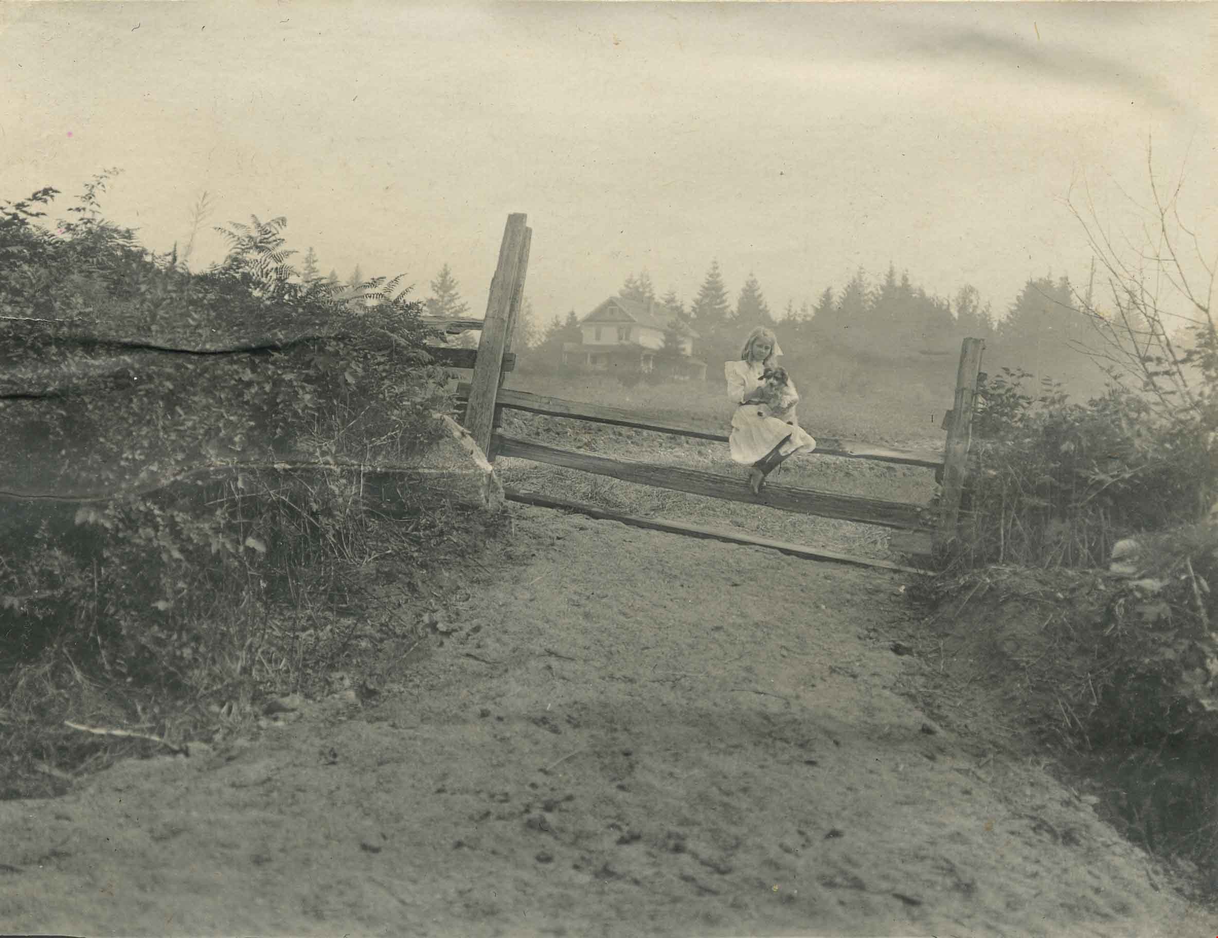
Kitty Hill sitting on a fence
https://search.heritageburnaby.ca/link/archivedescription39559
- Repository
- City of Burnaby Archives
- Date
- 1910
- Collection/Fonds
- Peers Family and Hill Family fonds
- Description Level
- Item
- Physical Description
- 1 photograph : b&w ; 7.8 x 10.1 cm on page 21.5 x 28 cm (pasted in album0
- Scope and Content
- Photograph of Kitty Hill sitting on a fence, holding a dog in her lap. The Hill family home, known as Broadview, is faintly visible in the background. It was located on Buckingham Avenue.
- Repository
- City of Burnaby Archives
- Date
- 1910
- Collection/Fonds
- Peers Family and Hill Family fonds
- Physical Description
- 1 photograph : b&w ; 7.8 x 10.1 cm on page 21.5 x 28 cm (pasted in album0
- Description Level
- Item
- Record No.
- 477-878
- Access Restriction
- No restrictions
- Reproduction Restriction
- No known restrictions
- Accession Number
- 2007-12
- Scope and Content
- Photograph of Kitty Hill sitting on a fence, holding a dog in her lap. The Hill family home, known as Broadview, is faintly visible in the background. It was located on Buckingham Avenue.
- Subjects
- Animals - Dogs
- Structures - Fences
- Media Type
- Photograph
- Notes
- Title based on contents of photograph
- Geographic Access
- Buckingham Avenue
- Street Address
- 5730 Buckingham Avenue
- Historic Neighbourhood
- Burnaby Lake (Historic Neighbourhood)
- Planning Study Area
- Morley-Buckingham Area
Images
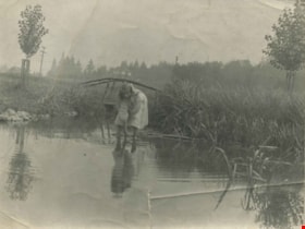
Kitty Hill wading in Deer Lake
https://search.heritageburnaby.ca/link/archivedescription39424
- Repository
- City of Burnaby Archives
- Date
- 1910
- Collection/Fonds
- Peers Family and Hill Family fonds
- Description Level
- Item
- Physical Description
- 1 photograph : b&w ; 7.2 x 10 cm
- Scope and Content
- Photograph of Kitty Hill wading in a small shallow creek. She has her feet submerged, and is dipping her hand in the water while looking up at the photographer. Just behind her is a small log bridge built over the creek, behind which can be seen a street lined with power poles, and a house in the …
- Repository
- City of Burnaby Archives
- Date
- 1910
- Collection/Fonds
- Peers Family and Hill Family fonds
- Physical Description
- 1 photograph : b&w ; 7.2 x 10 cm
- Description Level
- Item
- Record No.
- 477-743
- Access Restriction
- No restrictions
- Reproduction Restriction
- No known restrictions
- Accession Number
- 2007-12
- Scope and Content
- Photograph of Kitty Hill wading in a small shallow creek. She has her feet submerged, and is dipping her hand in the water while looking up at the photographer. Just behind her is a small log bridge built over the creek, behind which can be seen a street lined with power poles, and a house in the far distance, identified as "Broadview". An annotation on the back of the photo reads, "Kitty Hill 1910."
- Media Type
- Photograph
- Notes
- Title based on caption accompanying photograph
- Geographic Access
- Buckingham Avenue
- Deer Lake
- Street Address
- 5730 Buckingham Avenue
- Historic Neighbourhood
- Burnaby Lake (Historic Neighbourhood)
- Planning Study Area
- Morley-Buckingham Area
Images

![Labourers at work, [1919] thumbnail](/media/hpo/_Data/_BVM_Images/1974/197500330003bb.jpg?width=280)
Labourers at work
https://search.heritageburnaby.ca/link/museumdescription3479
- Repository
- Burnaby Village Museum
- Date
- [1919]
- Collection/Fonds
- Burnaby Village Museum Photograph collection
- Description Level
- Item
- Physical Description
- 1 photograph : sepia ; 5 x 7.5 cm
- Scope and Content
- Photograph of four labourers working on a pier constructed over an unidentified body of water.
- Repository
- Burnaby Village Museum
- Collection/Fonds
- Burnaby Village Museum Photograph collection
- Description Level
- Item
- Physical Description
- 1 photograph : sepia ; 5 x 7.5 cm
- Scope and Content
- Photograph of four labourers working on a pier constructed over an unidentified body of water.
- Accession Code
- HV975.33.3bb
- Access Restriction
- No restrictions
- Date
- [1919]
- Media Type
- Photograph
- Scan Resolution
- 600
- Scan Date
- 2/2/2010
- Scale
- 100
- Notes
- Title based on contents of photograph
- Image from personal photograph album of Tom "Tommy" Irvine (HV975.33.3)
Images
![Labourers at work, [1919] thumbnail](/media/hpo/_Data/_BVM_Images/1974/197500330003bb.jpg)
![Labourers at work, [1919] thumbnail](/media/hpo/_Data/_BVM_Images/1974/197500330003bg.jpg?width=280)
Labourers at work
https://search.heritageburnaby.ca/link/museumdescription3483
- Repository
- Burnaby Village Museum
- Date
- [1919]
- Collection/Fonds
- Burnaby Village Museum Photograph collection
- Description Level
- Item
- Physical Description
- 1 photograph : sepia ; 5 x 7.5 cm
- Scope and Content
- Photograph of five labourers working on a pier constructed over an unidentified body of water.
- Repository
- Burnaby Village Museum
- Collection/Fonds
- Burnaby Village Museum Photograph collection
- Description Level
- Item
- Physical Description
- 1 photograph : sepia ; 5 x 7.5 cm
- Scope and Content
- Photograph of five labourers working on a pier constructed over an unidentified body of water.
- Accession Code
- HV975.33.3bg
- Access Restriction
- No restrictions
- Date
- [1919]
- Media Type
- Photograph
- Scan Resolution
- 600
- Scan Date
- 2/2/2010
- Scale
- 100
- Notes
- Title based on contents of photograph
- Image from personal photograph album of Tom "Tommy" Irvine (HV975.33.3)
Images
![Labourers at work, [1919] thumbnail](/media/hpo/_Data/_BVM_Images/1974/197500330003bg.jpg)
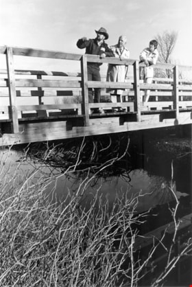
Liz Thurstrom, Bob Gardner, and Ken Elliot
https://search.heritageburnaby.ca/link/archivedescription78731
- Repository
- City of Burnaby Archives
- Date
- December 10, 1995
- Collection/Fonds
- Burnaby NewsLeader photograph collection
- Description Level
- Item
- Physical Description
- 1 photograph : b&w ; 23.5 x 16 cm
- Scope and Content
- Photograph of Liz Thurstrom, of the Wildlife Rescue Association of British Columbia, Bob Gardner, of the Burnaby Lake advisory council and Ken Elliot, of the Greater Vancouver Regional District (GVRD) atop the new footbridge completing the Burnaby Lake Trail.
- Repository
- City of Burnaby Archives
- Date
- December 10, 1995
- Collection/Fonds
- Burnaby NewsLeader photograph collection
- Physical Description
- 1 photograph : b&w ; 23.5 x 16 cm
- Description Level
- Item
- Record No.
- 535-0088
- Access Restriction
- No restrictions
- Reproduction Restriction
- No reproduction permitted
- Accession Number
- 2012-11
- Scope and Content
- Photograph of Liz Thurstrom, of the Wildlife Rescue Association of British Columbia, Bob Gardner, of the Burnaby Lake advisory council and Ken Elliot, of the Greater Vancouver Regional District (GVRD) atop the new footbridge completing the Burnaby Lake Trail.
- Media Type
- Photograph
- Photographer
- Bartel, Mario
- Notes
- Title based on contents of photograph
- Note in black and blue ink on recto of photograph reads: "3454 A Bby Mario / 95% Bby p.1"
- Trim marks and/or reproduction instructions on recto (scan is cropped)
- Geographic Access
- Burnaby Lake
Images

![Local construction, [1999] thumbnail](/media/hpo/_Data/_Archives_Images/_Unrestricted/535/535-3205-1.jpg?width=280)
Local construction
https://search.heritageburnaby.ca/link/archivedescription98126
- Repository
- City of Burnaby Archives
- Date
- [1999]
- Collection/Fonds
- Burnaby NewsLeader photograph collection
- Description Level
- File
- Physical Description
- 2 photographs (tiff) : col.
- Scope and Content
- File contains photographs of two unidentified people observing evidence of construction. One photograph depicts a person looking at a crack in a floor tile while holding a land survey map, and the other depicts an individual looking at a piece of construction equipment on the other side of a chain …
- Repository
- City of Burnaby Archives
- Date
- [1999]
- Collection/Fonds
- Burnaby NewsLeader photograph collection
- Physical Description
- 2 photographs (tiff) : col.
- Description Level
- File
- Record No.
- 535-3205
- Access Restriction
- No restrictions
- Reproduction Restriction
- No restrictions
- Accession Number
- 2018-12
- Scope and Content
- File contains photographs of two unidentified people observing evidence of construction. One photograph depicts a person looking at a crack in a floor tile while holding a land survey map, and the other depicts an individual looking at a piece of construction equipment on the other side of a chain link fence.
- Media Type
- Photograph
- Notes
- Title based on contents of file
- Collected by editorial for use in a June 1999 issue of the Burnaby NewsLeader
Images
![Local construction, [1999] thumbnail](/media/hpo/_Data/_Archives_Images/_Unrestricted/535/535-3205-1.jpg)
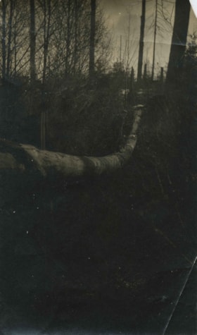
Log bridge
https://search.heritageburnaby.ca/link/archivedescription36025
- Repository
- City of Burnaby Archives
- Date
- 1912
- Collection/Fonds
- Burnaby Historical Society fonds
- Description Level
- Item
- Physical Description
- 1 photograph : b&w ; 14 x 8 cm
- Scope and Content
- Photograph of a log in the creek at Edmonds, acting as a bridge across the creek.
- Repository
- City of Burnaby Archives
- Date
- 1912
- Collection/Fonds
- Burnaby Historical Society fonds
- Subseries
- Patterson family subseries
- Physical Description
- 1 photograph : b&w ; 14 x 8 cm
- Material Details
- Photograph is very dark
- Description Level
- Item
- Record No.
- 213-007
- Access Restriction
- No restrictions
- Reproduction Restriction
- No known restrictions
- Accession Number
- BHS1988-13
- Scope and Content
- Photograph of a log in the creek at Edmonds, acting as a bridge across the creek.
- Subjects
- Structures - Bridges
- Media Type
- Photograph
- Notes
- Title based on contents of photograph
- Handwritten note on verso of photograph reads: " a big log in the creek at Edmonds"
- Quote associated with photograph reads: "Powerhouse Creek at foot of Edmonds"
- Historic Neighbourhood
- Edmonds (Historic Neighbourhood)
- Planning Study Area
- Edmonds Area
Images

![Love and Whiting families picnicing under tent, [c. 1910] thumbnail](/media/hpo/_Data/_BVM_Images/2022/2022_0032_0029_001.jpg?width=280)
Love and Whiting families picnicing under tent
https://search.heritageburnaby.ca/link/museumdescription19312
- Repository
- Burnaby Village Museum
- Date
- [c. 1910]
- Collection/Fonds
- Esther Love Stanley fonds
- Description Level
- Item
- Physical Description
- 1 photograph : b&w ; 8.5 x 11 cm
- Scope and Content
- Photograph of members of the Love and Whiting families gathered together for a meal under a canvas tent. The group is gathered around a long table that is in the middle of the tent. Annie Elizabeth (Love) Whiting is identified as the woman who is holding a young child in her lap, seated at the end …
- Repository
- Burnaby Village Museum
- Collection/Fonds
- Esther Love Stanley fonds
- Description Level
- Item
- Physical Description
- 1 photograph : b&w ; 8.5 x 11 cm
- Material Details
- Photograph is over exposed, washing out some of the detail
- Scope and Content
- Photograph of members of the Love and Whiting families gathered together for a meal under a canvas tent. The group is gathered around a long table that is in the middle of the tent. Annie Elizabeth (Love) Whiting is identified as the woman who is holding a young child in her lap, seated at the end of the table closest to the stove. A wood stove with pots and a kettle is visible in the foreground. The location is identified as Boundary Bay.
- Accession Code
- BV022.32.29
- Access Restriction
- No restrictions
- Reproduction Restriction
- No known restrictions
- Date
- [c. 1910]
- Media Type
- Photograph
- Scan Resolution
- 600
- Scan Date
- 2023-04-04
- Notes
- Title based on contents of photograph
- Photograph is part of Esther Love Stanley photograph album 1 (BV022.32.1)
- Note in white ink on album page reads: "BOUNDARY BAY?"
Images
![Love and Whiting families picnicing under tent, [c. 1910] thumbnail](/media/hpo/_Data/_BVM_Images/2022/2022_0032_0029_001.jpg)
![Man in front of tent, [between 1900 and 1915] thumbnail](/media/hpo/_Data/_BVM_Images/1983/1983_0042_0134_001.jpg?width=280)
Man in front of tent
https://search.heritageburnaby.ca/link/museumdescription394
- Repository
- Burnaby Village Museum
- Date
- [between 1900 and 1915]
- Collection/Fonds
- Burnaby Village Museum Photograph collection
- Description Level
- Item
- Physical Description
- 1 photograph : b&w ; 10.8 x 13.34 cm
- Scope and Content
- Photograph of a young man sitting in front of a tent that is put up off ground on a wooden support in the middle of the woods. The man is wearing a vest over his shirt, a flat hat, and is holding a broom and pretending to play guitar with it. Near the tip of the tent is a company mark that reads "J…
- Repository
- Burnaby Village Museum
- Collection/Fonds
- Burnaby Village Museum Photograph collection
- Description Level
- Item
- Physical Description
- 1 photograph : b&w ; 10.8 x 13.34 cm
- Material Details
- Inscribed on the card mount in pencil, verso, t. "land to your [illegible word] and grand/ right and left and all almain/ in the corner"
- Photograph is mounted on a black card. Torn on u.r.
- Scope and Content
- Photograph of a young man sitting in front of a tent that is put up off ground on a wooden support in the middle of the woods. The man is wearing a vest over his shirt, a flat hat, and is holding a broom and pretending to play guitar with it. Near the tip of the tent is a company mark that reads "JAMES MARTIN & SON/ MAKERS/ 114 [?] COMMERCIAL St/ BOSTON"
- Subjects
- Structures - Tents
- Accession Code
- HV983.42.134
- Reproduction Restriction
- No known restrictions
- Date
- [between 1900 and 1915]
- Media Type
- Photograph
- Scan Resolution
- 600
- Scan Date
- 2023-12-05
Images
![Man in front of tent, [between 1900 and 1915] thumbnail](/media/hpo/_Data/_BVM_Images/1983/1983_0042_0134_001.jpg)
![Man on a bridge, [1919] thumbnail](/media/hpo/_Data/_BVM_Images/1974/197500330003bf.jpg?width=280)
Man on a bridge
https://search.heritageburnaby.ca/link/museumdescription3482
- Repository
- Burnaby Village Museum
- Date
- [1919]
- Collection/Fonds
- Burnaby Village Museum Photograph collection
- Description Level
- Item
- Physical Description
- 1 photograph : sepia ; 10 x 6 cm
- Scope and Content
- Photograph of a man walking along a wooden bridge in the interior plateau of British Columbia.
- Repository
- Burnaby Village Museum
- Collection/Fonds
- Burnaby Village Museum Photograph collection
- Description Level
- Item
- Physical Description
- 1 photograph : sepia ; 10 x 6 cm
- Scope and Content
- Photograph of a man walking along a wooden bridge in the interior plateau of British Columbia.
- Subjects
- Structures - Bridges
- Accession Code
- HV975.33.3bf
- Access Restriction
- No restrictions
- Date
- [1919]
- Media Type
- Photograph
- Scan Resolution
- 600
- Scan Date
- 2/2/2010
- Scale
- 100
- Notes
- Title based on contents of photograph
- Image from personal photograph album of Tom "Tommy" Irvine (HV975.33.3)
Images
![Man on a bridge, [1919] thumbnail](/media/hpo/_Data/_BVM_Images/1974/197500330003bf.jpg)
![Minnie Coe and Evelyn Condio, [between 1910 and 1929] thumbnail](/media/hpo/_Data/_BVM_Images/2000/200100010347.jpg?width=280)
Minnie Coe and Evelyn Condio
https://search.heritageburnaby.ca/link/museumdescription1643
- Repository
- Burnaby Village Museum
- Date
- [between 1910 and 1929]
- Collection/Fonds
- Burnaby Village Museum Photograph collection
- Description Level
- Item
- Physical Description
- 1 photograph : sepia ; 14 x 8 cm
- Scope and Content
- Photograph of cousins Mignon (Minnie) Coe and Evelyn Condio standing together in front of the arbour at the Coe family residence at 2684 Fern Avenue (renumbered in the 6300 block). Mignon Coe (later Uter) was the daughter of Elizabeth and James Coe.
- Repository
- Burnaby Village Museum
- Collection/Fonds
- Burnaby Village Museum Photograph collection
- Description Level
- Item
- Physical Description
- 1 photograph : sepia ; 14 x 8 cm
- Scope and Content
- Photograph of cousins Mignon (Minnie) Coe and Evelyn Condio standing together in front of the arbour at the Coe family residence at 2684 Fern Avenue (renumbered in the 6300 block). Mignon Coe (later Uter) was the daughter of Elizabeth and James Coe.
- Geographic Access
- Fern Avenue
- Accession Code
- BV001.1.347
- Access Restriction
- No restrictions
- Date
- [between 1910 and 1929]
- Media Type
- Photograph
- Historic Neighbourhood
- Central Park (Historic Neighbourhood)
- Planning Study Area
- Marlborough Area
- Scan Resolution
- 600
- Scan Date
- 09-Jun-09
- Scale
- 100
- Notes
- Title based on contents of photograph
- Note in pencil on verso of photograph reads: "Minnie Coe + Evelyn Condio cousin"
Images
![Minnie Coe and Evelyn Condio, [between 1910 and 1929] thumbnail](/media/hpo/_Data/_BVM_Images/2000/200100010347.jpg)