Narrow Results By
Subject
- Animals - Dogs 1
- Buildings - Industrial - Mills 1
- Buildings - Residences - Houses 1
- Buildings - Residential - Houses 4
- Construction 2
- Construction - Road Construction 1
- Documentary Artifacts - Postcards 3
- Geographic Features - Inlets 1
- Geographic Features - Parks 1
- Land Clearing
- Maunfactured Products - Logs 1
- Natural Phenomena - Snow 1
![Setting the blast, [1910 or 1911] thumbnail](/media/hpo/_Data/_Archives_Images/_Unrestricted/487/487-036.jpg?width=280)
Setting the blast
https://search.heritageburnaby.ca/link/archivedescription65898
- Repository
- City of Burnaby Archives
- Date
- [1910 or 1911]
- Collection/Fonds
- J.W. Phillips fonds
- Description Level
- Item
- Physical Description
- 1 photograph : b&w glass negative ; 15.5 x 11 cm
- Scope and Content
- Photograph of an unidentified man (likely John William "Jack" Holmes) helping to clear land near the Phillips home on Ellsemere Avenue. Holding a fuse in his hands with dynamite resting in front of him, he is crouched in front of a large stump, setting the blast.
- Repository
- City of Burnaby Archives
- Date
- [1910 or 1911]
- Collection/Fonds
- J.W. Phillips fonds
- Physical Description
- 1 photograph : b&w glass negative ; 15.5 x 11 cm
- Material Details
- Emulsion measures 15.5 x 11 cm on the glass; entire glass plate measures 16 x 12 cm
- Description Level
- Item
- Record No.
- 487-036
- Access Restriction
- No restrictions
- Reproduction Restriction
- No known restrictions
- Accession Number
- 2008-18
- Scope and Content
- Photograph of an unidentified man (likely John William "Jack" Holmes) helping to clear land near the Phillips home on Ellsemere Avenue. Holding a fuse in his hands with dynamite resting in front of him, he is crouched in front of a large stump, setting the blast.
- Subjects
- Land Clearing
- Media Type
- Photograph
- Photographer
- Phillips, James William "Jim"
- Notes
- Title based on contents of photograph
- Geographic Access
- Ellesmere Avenue
- Street Address
- 200 Ellesmere Avenue
- Historic Neighbourhood
- Capitol Hill (Historic Neighbourhood)
- Planning Study Area
- Capitol Hill Area
Images
![Setting the blast, [1910 or 1911] thumbnail](/media/hpo/_Data/_Archives_Images/_Unrestricted/487/487-036.jpg)

Tired Tim and Weary Willie
https://search.heritageburnaby.ca/link/archivedescription38855
- Repository
- City of Burnaby Archives
- Date
- 1911
- Collection/Fonds
- Peers Family and Hill Family fonds
- Description Level
- Item
- Physical Description
- 1 photograph : sepia ; 6 x 10 cm on page 14 x 17.5 cm (pasted in album)
- Scope and Content
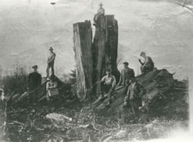
- Photograph of Claude Hill (left) and E.B. Wentenhall (right) standing on fallen trees in the Curtis Road area of North Burnaby.
- Repository
- City of Burnaby Archives
- Date
- 1911
- Collection/Fonds
- Peers Family and Hill Family fonds
- Physical Description
- 1 photograph : sepia ; 6 x 10 cm on page 14 x 17.5 cm (pasted in album)
- Description Level
- Item
- Record No.
- 477-174
- Access Restriction
- No restrictions
- Reproduction Restriction
- No known restrictions
- Accession Number
- 2007-12
- Scope and Content
- Photograph of Claude Hill (left) and E.B. Wentenhall (right) standing on fallen trees in the Curtis Road area of North Burnaby.
- Subjects
- Land Clearing
- Plants - Trees
- Media Type
- Photograph
- Notes
- Title based on caption accompanying photograph
- Geographic Access
- Curtis Street
- Historic Neighbourhood
- Lochdale (Historic Neighbourhood)
- Planning Study Area
- Lochdale Area
Images

William Walker and his crew
https://search.heritageburnaby.ca/link/archivedescription35368
- Repository
- City of Burnaby Archives
- Date
- 1913 (date of original), copied 1986
- Collection/Fonds
- Burnaby Historical Society fonds
- Description Level
- Item
- Physical Description
- 1 photograph : b&w ; 12.7 x 17.8 cm print
- Scope and Content
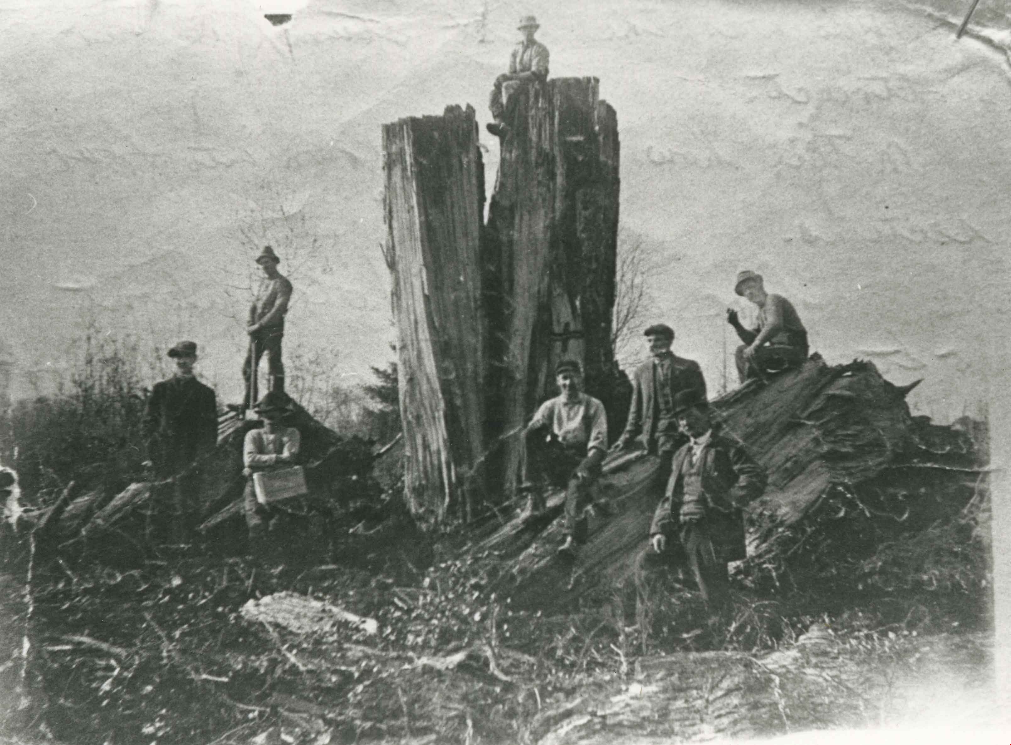
- Photograph of William Walker, a member of a crew contracted by the municipality to clear the area between Colborne Avenue, Brantford Avenue and Imperial Street in South Burnaby The land was cleared by blasting. The tree in this picture measured 24 feet in circumference.
- Repository
- City of Burnaby Archives
- Date
- 1913 (date of original), copied 1986
- Collection/Fonds
- Burnaby Historical Society fonds
- Subseries
- Pioneer Tales subseries
- Physical Description
- 1 photograph : b&w ; 12.7 x 17.8 cm print
- Description Level
- Item
- Record No.
- 204-225
- Access Restriction
- No restrictions
- Reproduction Restriction
- No known restrictions
- Accession Number
- BHS1988-03
- Scope and Content
- Photograph of William Walker, a member of a crew contracted by the municipality to clear the area between Colborne Avenue, Brantford Avenue and Imperial Street in South Burnaby The land was cleared by blasting. The tree in this picture measured 24 feet in circumference.
- Subjects
- Land Clearing
- Plants - Trees
- Names
- Walker, William
- Media Type
- Photograph
- Notes
- Title based on contents of photograph
- Historic Neighbourhood
- Edmonds (Historic Neighbourhood)
- Planning Study Area
- Kingsway-Beresford Area
Images