Narrow Results By
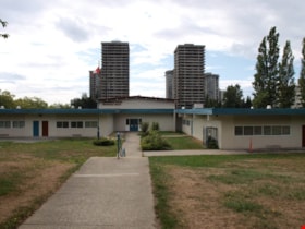
Cameron Elementary School
https://search.heritageburnaby.ca/link/landmark833
- Repository
- Burnaby Heritage Planning
- Geographic Access
- Erickson Drive
- Associated Dates
- 1965
- Heritage Value
- The increasing density of housing around the Lougheed Shopping Centre area resulted in a spike in enrolment at Lyndhurst Elementary School. As a result, in 1965, Cameron Road Elementary was built to alleviate overcrowding issues. The school opened with 151 pupils. The school was expanded in 1969 when three classrooms were added and again in 1971 when eights more rooms and a library were built.
- Historic Neighbourhood
- Burquitlam (Historic Neighbourhood)
- Planning Study Area
- Cameron Area
- Street Address
- 9540 Erickson Drive
- Street View URL
- Google Maps Street View
Images
North Road near Lougheed Highway
https://search.heritageburnaby.ca/link/museumdescription3100
- Repository
- Burnaby Village Museum
- Date
- [1914]
- Collection/Fonds
- Burnaby Village Museum Photograph collection
- Description Level
- Item
- Physical Description
- 1 photograph : b&w glass negative ; 15.7 x 19.8 cm
- Scope and Content
- Photograph of a paved road lined with electric poles on both sides and a wood plank sidewalk on one side of the road. There are two men in suits on the left, in the distance. Also visible are houses to the right. An earlier catalogue record from 1988 conjectures that the photograph is a view of No…
- Repository
- Burnaby Village Museum
- Collection/Fonds
- Burnaby Village Museum Photograph collection
- Description Level
- Item
- Physical Description
- 1 photograph : b&w glass negative ; 15.7 x 19.8 cm
- Scope and Content
- Photograph of a paved road lined with electric poles on both sides and a wood plank sidewalk on one side of the road. There are two men in suits on the left, in the distance. Also visible are houses to the right. An earlier catalogue record from 1988 conjectures that the photograph is a view of North Road near the modern day intersection of Lougheed Highway, looking south to New Westminster. The record also dates the negative, ca. 1914.
- Subjects
- Geographic Features - Roads
- Geographic Access
- North Road
- Lougheed Highway
- Accession Code
- HV972.11.14
- Access Restriction
- No restrictions
- Reproduction Restriction
- No known restrictions
- Date
- [1914]
- Media Type
- Photograph
- Historic Neighbourhood
- Burquitlam (Historic Neighbourhood)
- Planning Study Area
- Cameron Area
- Related Material
- 600 dpi .TIF scan of master copy contact sheet image available at Q:\51305 BVM Collections\BVM Photographs\1970
- Scan Resolution
- 300
- Scan Date
- 14/8/2006
- Scale
- 100
- Notes
- Title based on contents of photograph
- 1 b&w contact print accompanying negative

![North Road near Lougheed Highway, [1914] thumbnail](/media/hpo/_Data/_BVM_Images/1971/197200110014.jpg?width=280)