Narrow Results By

Schou Street School
https://search.heritageburnaby.ca/link/landmark637
- Repository
- Burnaby Heritage Planning
- Description
- School building.
- Associated Dates
- 1914
- Street View URL
- Google Maps Street View
- Repository
- Burnaby Heritage Planning
- Geographic Access
- Norfolk Street
- Associated Dates
- 1914
- Description
- School building.
- Heritage Value
- This school was built to replace tents and temporary buildings that had previously been used for the local children of the Broadview neighbourhood. The site was donated to the School Board in 1911 by the real estate firm of Leibly & Blumer in anticipation of increased settlement in the district. The school was named after the street, which had been named after Nicolai Schou, Burnaby’s second Reeve. Originally designed in the Arts and Crafts style, the character of the school was altered in 1964 when its original siding was covered in stucco and the windows were replaced, but has retained its original form and massing, including its front gabled entrance with recessed doorway and twinned square columns. Of special note is the name of the school above the front entry.This school was designed by Joseph H. Bowman (1864-1943), a specialist in school buildings, who was retained as the school board architect for South Vancouver and Burnaby. One of his first designs for Burnaby was a utilitarian two-storey school that could be built with two classrooms and later expanded to eight rooms as the district’s school population grew; five schools from this design were built in 1908, and then four others in modified versions between 1910-16, including this school.
- Locality
- Broadview
- Historic Neighbourhood
- Broadview (Historic Neighbourhood)
- Planning Study Area
- Cascade-Schou Area
- Architect
- Joseph H. Bowman
- Area
- 7660.46
- Contributing Resource
- Building
- Street Address
- 4054 Norfolk Street
- Street View URL
- Google Maps Street View
Images


Bob and Olive Urquhart beside Boundary Road
https://search.heritageburnaby.ca/link/archivedescription36759
- Repository
- City of Burnaby Archives
- Date
- March 19, 1913 (date of original), copied 1992
- Collection/Fonds
- Burnaby Historical Society fonds
- Description Level
- Item
- Physical Description
- 1 photograph : b&w ; 10 x 8 cm print
- Scope and Content
- Photograph of Bob and Olive Urquhart soon after their marriage, (they were married March 15). Note the new wood planking on Boundary Road and the train track crossing sign past the house in the distance for the Burnaby Lake Interurban tram line. This photograph was taken looking north on Boundary…
- Repository
- City of Burnaby Archives
- Date
- March 19, 1913 (date of original), copied 1992
- Collection/Fonds
- Burnaby Historical Society fonds
- Subseries
- Burnaby Centennial Anthology subseries
- Physical Description
- 1 photograph : b&w ; 10 x 8 cm print
- Description Level
- Item
- Record No.
- 315-114
- Access Restriction
- No restrictions
- Reproduction Restriction
- No known restrictions
- Accession Number
- BHS1994-04
- Scope and Content
- Photograph of Bob and Olive Urquhart soon after their marriage, (they were married March 15). Note the new wood planking on Boundary Road and the train track crossing sign past the house in the distance for the Burnaby Lake Interurban tram line. This photograph was taken looking north on Boundary Road just south of the railway tracks.
- Subjects
- Geographic Features - Roads
- Media Type
- Photograph
- Notes
- Title based on contents of photograph
- Geographic Access
- Boundary Road
- Myrtle Street
- Historic Neighbourhood
- Broadview (Historic Neighbourhood)
- Planning Study Area
- West Central Valley Area
Images


E.W. Nicholson Home in Broadview District
https://search.heritageburnaby.ca/link/archivedescription38254
- Repository
- City of Burnaby Archives
- Date
- 1913
- Collection/Fonds
- Burnaby Historical Society fonds
- Description Level
- Item
- Physical Description
- 1 photograph : b&w ; 9 x 13 cm
- Scope and Content
- Photograph of a man identified as E.W. Nicholson standing in front of his home in the Broadview district.
- Repository
- City of Burnaby Archives
- Date
- 1913
- Collection/Fonds
- Burnaby Historical Society fonds
- Subseries
- Margaret McCallum subseries
- Physical Description
- 1 photograph : b&w ; 9 x 13 cm
- Description Level
- Item
- Record No.
- 375-016
- Access Restriction
- No restrictions
- Reproduction Restriction
- No known restrictions
- Accession Number
- BHS1986-42
- Scope and Content
- Photograph of a man identified as E.W. Nicholson standing in front of his home in the Broadview district.
- Subjects
- Buildings - Residential - Houses
- Names
- Nicholson, E.W.
- Media Type
- Photograph
- Notes
- Title based on caption
- A note on the back of the photograph reads: "First May Day in Broadview District of Burnaby. May 1913. E.W. Nicholson and home."
- Geographic Access
- Boundary Road
- Street Address
- 2550 Boundary Road
- Historic Neighbourhood
- Broadview (Historic Neighbourhood)
- Planning Study Area
- West Central Valley Area
Images


Nicholson Farm
https://search.heritageburnaby.ca/link/archivedescription38255
- Repository
- City of Burnaby Archives
- Date
- 1910
- Collection/Fonds
- Burnaby Historical Society fonds
- Description Level
- Item
- Physical Description
- 1 photograph : b&w ; 10.2 x 15.2 cm
- Scope and Content
- Photograph of the home and barns at the farm of E.W. Nicholson and Elsie Nicholson.
- Repository
- City of Burnaby Archives
- Date
- 1910
- Collection/Fonds
- Burnaby Historical Society fonds
- Subseries
- Margaret McCallum subseries
- Physical Description
- 1 photograph : b&w ; 10.2 x 15.2 cm
- Description Level
- Item
- Record No.
- 375-017
- Access Restriction
- No restrictions
- Reproduction Restriction
- No known restrictions
- Accession Number
- BHS1986-42
- Scope and Content
- Photograph of the home and barns at the farm of E.W. Nicholson and Elsie Nicholson.
- Media Type
- Photograph
- Notes
- Title based on contents of photograph
- A note on the back of the photograph reads: "Home of E.W. Nicholson 1900-1951 and Elsie Nicholson 1934-1951. Boundary Road and Great Northern Railway. Property sold to Link-Belt Co. in 1951."
- Geographic Access
- Boundary Road
- Street Address
- 2550 Boundary Road
- Historic Neighbourhood
- Broadview (Historic Neighbourhood)
- Planning Study Area
- West Central Valley Area
Images

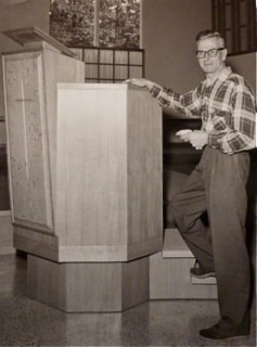
William Myers at St Andrews altar
https://search.heritageburnaby.ca/link/archivedescription88373
- Repository
- City of Burnaby Archives
- Date
- 1961 (date of original)
- Collection/Fonds
- Elaine A. Myers fonds
- Description Level
- Item
- Physical Description
- 1 photograph (jpeg) : sepia ; 96 dpi
- Scope and Content
- Photograph of Elaine's father, William Myers next to the the altar of St. Andrews Church that he built.
- Repository
- City of Burnaby Archives
- Date
- 1961 (date of original)
- Collection/Fonds
- Elaine A. Myers fonds
- Physical Description
- 1 photograph (jpeg) : sepia ; 96 dpi
- Material Details
- Jpeg is a copy created by the donor of a sepia original
- Description Level
- Item
- Record No.
- 580-003
- Access Restriction
- No restrictions
- Reproduction Restriction
- No restrictions
- Accession Number
- 2013-26
- Scope and Content
- Photograph of Elaine's father, William Myers next to the the altar of St. Andrews Church that he built.
- Subjects
- Buildings - Religious - Churches
- Media Type
- Photograph
- Notes
- Title based on contents of photograph
- Geographic Access
- Norfolk Street
- Gilmore Avenue
- Historic Neighbourhood
- Broadview (Historic Neighbourhood)
- Planning Study Area
- Cascade-Schou Area
Images
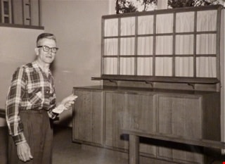

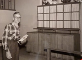
William Myers at St. Andrews pulpit
https://search.heritageburnaby.ca/link/archivedescription88374
- Repository
- City of Burnaby Archives
- Date
- 1961 (date of original)
- Collection/Fonds
- Elaine A. Myers fonds
- Description Level
- Item
- Physical Description
- 1 photograph (jpeg) : sepia ; 96 dpi
- Scope and Content
- Photograph of Elaine's father, William Myers next to the pulpit of St. Andrews Church that he built.
- Repository
- City of Burnaby Archives
- Date
- 1961 (date of original)
- Collection/Fonds
- Elaine A. Myers fonds
- Physical Description
- 1 photograph (jpeg) : sepia ; 96 dpi
- Material Details
- Jpeg is a copy created by the donor of a sepia original
- Description Level
- Item
- Record No.
- 580-004
- Access Restriction
- No restrictions
- Reproduction Restriction
- No restrictions
- Accession Number
- 2013-26
- Scope and Content
- Photograph of Elaine's father, William Myers next to the pulpit of St. Andrews Church that he built.
- Subjects
- Buildings - Religious - Churches
- Media Type
- Photograph
- Notes
- Title based on contents of photograph
- Geographic Access
- Norfolk Street
- Gilmore Avenue
- Historic Neighbourhood
- Broadview (Historic Neighbourhood)
- Planning Study Area
- Cascade-Schou Area
Images
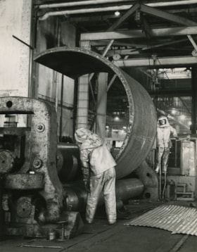
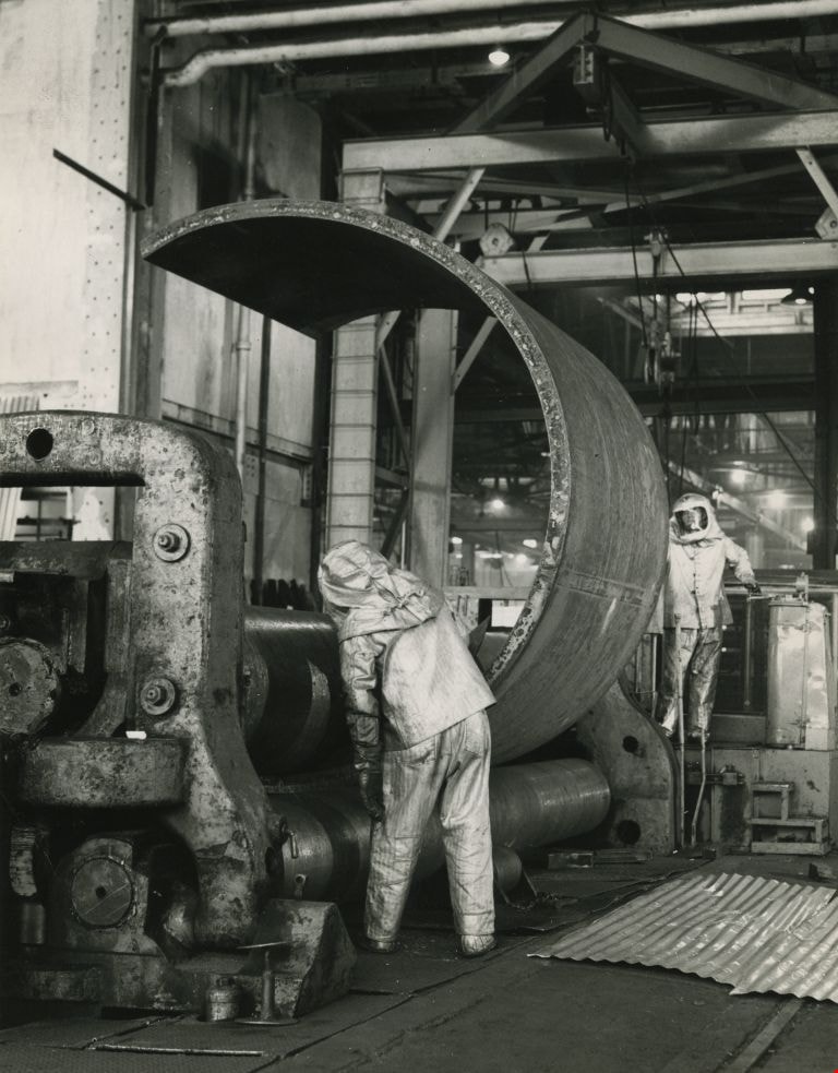
Working at the Dominion Bridge Co.'s Burnaby plant
https://search.heritageburnaby.ca/link/archivedescription45613
- Repository
- City of Burnaby Archives
- Date
- April 1966, published April 18, 1966
- Collection/Fonds
- Columbian Newspaper collection
- Description Level
- Item
- Physical Description
- 1 photograph : b&w ; 24 x 18.5 cm
- Scope and Content
- Photograph of workmen at the Dominion Bridge Co.'s Burnaby plant. They are feeding a flat steel plate, more than three inches think inot a pyramind roll for fabrication in the making of a sulfinol vessel for the petroleum industry in Alberta. The workmen are wearing asbestos aluminum suits to withs…
- Repository
- City of Burnaby Archives
- Date
- April 1966, published April 18, 1966
- Collection/Fonds
- Columbian Newspaper collection
- Physical Description
- 1 photograph : b&w ; 24 x 18.5 cm
- Description Level
- Item
- Record No.
- 480-507
- Access Restriction
- No restrictions
- Reproduction Restriction
- Reproduce for fair dealing purposes only
- Accession Number
- 2003-02
- Scope and Content
- Photograph of workmen at the Dominion Bridge Co.'s Burnaby plant. They are feeding a flat steel plate, more than three inches think inot a pyramind roll for fabrication in the making of a sulfinol vessel for the petroleum industry in Alberta. The workmen are wearing asbestos aluminum suits to withstand the intense heat reflected from the heated plate (the plate was heated in a furnace before being fed into the pyramid roll).
- Names
- Dominion Bridge Company
- Media Type
- Photograph
- Photographer
- Henry Tregillas Photography Ltd.
- Notes
- Title based on contents of photograph
- Geographic Access
- Boundary Road
- Street Address
- 2400 Boundary Road
- Historic Neighbourhood
- Broadview (Historic Neighbourhood)
- Planning Study Area
- West Central Valley Area
Images