Narrow Results By
Subject
- Aerial Photographs 1
- Agriculture - Farms 1
- Animals - Dogs 1
- Buildings - Industrial 1
- Buildings - Residential - Houses 2
- Geographic Features - Automobile Parking Lots 1
- Geographic Features - Roads 1
- Geographic Features - Streams 1
- Land Clearing 1
- Occupations - Teachers 2
- Plants - Trees 1
- Structures - Bridges 1

Government Road
https://search.heritageburnaby.ca/link/archivedescription35567
- Repository
- City of Burnaby Archives
- Date
- 1912 (date of original), copied 1986
- Collection/Fonds
- Burnaby Historical Society fonds
- Description Level
- Item
- Physical Description
- 1 photograph : b&w ; 12.7 x 17.8 cm print
- Scope and Content
- Photograph looking east on Government Road from the Haddon family house. One of the men in the photo is Robert Haddon. The other two people are unidentified. Note the loose gravel roadway and the bridge over Eagle Creek.
- Repository
- City of Burnaby Archives
- Date
- 1912 (date of original), copied 1986
- Collection/Fonds
- Burnaby Historical Society fonds
- Subseries
- Pioneer Tales subseries
- Physical Description
- 1 photograph : b&w ; 12.7 x 17.8 cm print
- Description Level
- Item
- Record No.
- 204-425
- Access Restriction
- No restrictions
- Reproduction Restriction
- No known restrictions
- Accession Number
- BHS1988-03
- Scope and Content
- Photograph looking east on Government Road from the Haddon family house. One of the men in the photo is Robert Haddon. The other two people are unidentified. Note the loose gravel roadway and the bridge over Eagle Creek.
- Names
- Haddon, Robert
- Media Type
- Photograph
- Notes
- Title based on contents of photograph
- Geographic Access
- Eagle Creek
- Government Road
- Historic Neighbourhood
- Lozells (Historic Neighbourhood)
- Planning Study Area
- Government Road Area
Images

![Government Road property, [191-] (date of original), copied 1986 thumbnail](/media/hpo/_Data/_Archives_Images/_Unrestricted/204/204-689.jpg?width=280)
Government Road property
https://search.heritageburnaby.ca/link/archivedescription35830
- Repository
- City of Burnaby Archives
- Date
- [191-] (date of original), copied 1986
- Collection/Fonds
- Burnaby Historical Society fonds
- Description Level
- Item
- Physical Description
- 1 photograph : b&w ; 12.7 x 17.8 cm print
- Scope and Content
- Photograph of (left) James Ker (maternal grandfather), (right) Robert Haddon (father), and Gordon Haddon (son), cutting firewood from a large fallen fir with a Wee MacGregor chainsaw on their Hastings Mill property south of the family home on Government Road.
- Repository
- City of Burnaby Archives
- Date
- [191-] (date of original), copied 1986
- Collection/Fonds
- Burnaby Historical Society fonds
- Subseries
- Pioneer Tales subseries
- Physical Description
- 1 photograph : b&w ; 12.7 x 17.8 cm print
- Description Level
- Item
- Record No.
- 204-689
- Access Restriction
- No restrictions
- Reproduction Restriction
- No restrictions
- Accession Number
- BHS1988-03
- Scope and Content
- Photograph of (left) James Ker (maternal grandfather), (right) Robert Haddon (father), and Gordon Haddon (son), cutting firewood from a large fallen fir with a Wee MacGregor chainsaw on their Hastings Mill property south of the family home on Government Road.
- Subjects
- Land Clearing
- Plants - Trees
- Media Type
- Photograph
- Notes
- Title based on contents of photograph
- Geographic Access
- Government Road
- Historic Neighbourhood
- Lozells (Historic Neighbourhood)
- Planning Study Area
- Government Road Area
Images
![Government Road property, [191-] (date of original), copied 1986 thumbnail](/media/hpo/_Data/_Archives_Images/_Unrestricted/204/204-689.jpg)

Haddon family home
https://search.heritageburnaby.ca/link/archivedescription35564
- Repository
- City of Burnaby Archives
- Date
- 1919 (date of original), copied 1986
- Collection/Fonds
- Burnaby Historical Society fonds
- Description Level
- Item
- Physical Description
- 1 photograph : b&w ; 12.7 x 17.8 cm print
- Scope and Content
- Photograph of the Haddon family home at 7870 Government Road between Lozells Avenue and Piper Avenue. Three adults and a young child are standing in at the front door.
- Repository
- City of Burnaby Archives
- Date
- 1919 (date of original), copied 1986
- Collection/Fonds
- Burnaby Historical Society fonds
- Subseries
- Pioneer Tales subseries
- Physical Description
- 1 photograph : b&w ; 12.7 x 17.8 cm print
- Description Level
- Item
- Record No.
- 204-422
- Access Restriction
- No restrictions
- Reproduction Restriction
- No known restrictions
- Accession Number
- BHS1988-03
- Scope and Content
- Photograph of the Haddon family home at 7870 Government Road between Lozells Avenue and Piper Avenue. Three adults and a young child are standing in at the front door.
- Subjects
- Buildings - Residential - Houses
- Media Type
- Photograph
- Notes
- Title based on contents of photograph
- Geographic Access
- Government Road
- Street Address
- 7870 Government Road
- Historic Neighbourhood
- Lozells (Historic Neighbourhood)
- Planning Study Area
- Government Road Area
Images

Seaforth School Class
https://search.heritageburnaby.ca/link/archivedescription37341
- Repository
- City of Burnaby Archives
- Date
- 1950
- Collection/Fonds
- Burnaby Historical Society fonds
- Description Level
- Item
- Physical Description
- 1 photograph : b&w ; 12.5 x 17.7 cm
- Scope and Content
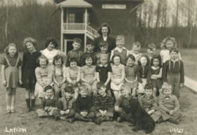
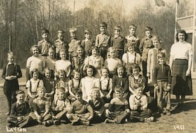
- Photograph of twenty-seven students and their teacher seated and standing in rows in front of the school building. A black dog is sitting in the front, facing the rows of children. A label on the back of the photograph states that the students are from Seaforth School. Identified in the photograp…
- Repository
- City of Burnaby Archives
- Date
- 1950
- Collection/Fonds
- Burnaby Historical Society fonds
- Subseries
- Seaforth School subseries
- Physical Description
- 1 photograph : b&w ; 12.5 x 17.7 cm
- Description Level
- Item
- Record No.
- 355-005
- Access Restriction
- No restrictions
- Reproduction Restriction
- Reproduce for fair dealing purposes only
- Accession Number
- BHS1997-14
- Scope and Content
- Photograph of twenty-seven students and their teacher seated and standing in rows in front of the school building. A black dog is sitting in the front, facing the rows of children. A label on the back of the photograph states that the students are from Seaforth School. Identified in the photograph are: Mrs. Mary Johnson (nee MacDonald) teacher, in the far back. Back row (l to r): Sandra ?, Shirley Colden, Marcia Noel, Eldon Clarke, Billy Beaton, David Park, Graeme Smith, Calvert Broomfield, Leigh Tucker and Lillian Savage. Middle row (l to r): Sharon Milne, Gail Simpson, Thelma Mornes, Joan Dachiuk, Barbara Smith, Betty Hadfield, Judy Haddon, Wilma Heather, Merle Beaton and Sammy Savage. Front row (l to r): Dennis Dachiuk, Jerry Hadfield, Mike Lawrence, David MacPhail, Sydney Clarke, Joe Haddon and Jerry Green.
- Subjects
- Animals - Dogs
- Occupations - Teachers
- Names
- Seaforth School
- Johnson, Mary MacDonald
- Colden, Shirley
- Noel, Marcia
- Clarke, Eldon
- Beaton, Billy
- Park, David
- Smith, Graeme
- Broomfield, Calvert
- Tucker, Leigh
- Savage, Lillian
- Anderson, Gail
- Sampson, Gail
- Mornes, Thelma
- Dachiuk, Joan
- Smith, Barbara
- Hadfield, Betty
- Haddon, Judy
- Heather, Wilma
- Beaton, Merle
- Savage, Sammy
- Dachiuk, Dennis
- Hadfield, Jerry
- Lawrence, Mike
- MacPhail, David
- Clarke, Sydney
- Haddon, Joe
- Green, Jerry
- Media Type
- Photograph
- Notes
- Title based on label on verso of photograph
- Photographer identified as "Layton"
- Geographic Access
- Government Road
- Deer Lake Avenue
- Street Address
- 7881 Government Road
- 6501 Deer Lake Avenue
- Historic Neighbourhood
- Lozells (Historic Neighbourhood)
- Planning Study Area
- Government Road Area
Images
Seaforth School Class
https://search.heritageburnaby.ca/link/archivedescription37342
- Repository
- City of Burnaby Archives
- Date
- 1951
- Collection/Fonds
- Burnaby Historical Society fonds
- Description Level
- Item
- Physical Description
- 1 photograph : b&w ; 12.7 x 17.7 cm
- Scope and Content
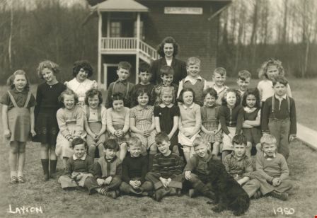
- Photograph of twenty-seven students and their teacher seated and standing in rows outside. A label on the back of the photograph states that the students are from Seaforth School. Identified are as follows: Mrs. Mary Johnson (nee MacDonald) teacher, far right. Back row (l to r): Glen Richardson,…
- Repository
- City of Burnaby Archives
- Date
- 1951
- Collection/Fonds
- Burnaby Historical Society fonds
- Subseries
- Seaforth School subseries
- Physical Description
- 1 photograph : b&w ; 12.7 x 17.7 cm
- Description Level
- Item
- Record No.
- 355-006
- Access Restriction
- No restrictions
- Reproduction Restriction
- Reproduce for fair dealing purposes only
- Accession Number
- BHS1997-14
- Scope and Content
- Photograph of twenty-seven students and their teacher seated and standing in rows outside. A label on the back of the photograph states that the students are from Seaforth School. Identified are as follows: Mrs. Mary Johnson (nee MacDonald) teacher, far right. Back row (l to r): Glen Richardson, Leigh Tucker, Brian Clarke, Sammy Savage, Eldon Clarke, David Park, Tommy Richardson, and Joe Haddon. Second row (l to r): Mike Lawrence (standing to the left), Sandra ?, Joan Olsen, Betty Hadfield, Donna Anderson, Wilma Heather, Barbara Smith, Gail Simpson and Shirley Colden. Third row (l to r): Lois Brown, Jackie Peskett, Gail Anderson, Joan Pescott, Merle Beaton, Judy Haddon, Joan Dachiuk, Thelma Mornes, and Jerry Hadfield (standing to the right). Front row (l to r): Dennis Dachiuk, Roy Olsen, David ?, Allen Beaton, Sydney Clarke, David McPhail, and Terry Burstyk.
- Subjects
- Occupations - Teachers
- Names
- Seaforth School
- Johnson, Mary MacDonald
- Richardson, Glen
- Tucker, Leigh
- Clarke, Brian
- Savage, Sammy
- Clarke, Eldon
- Park, David
- Richardson, Tommy
- Haddon, Joe
- Lawrence, Mike
- Olsen, Joan
- Hadfield, Betty
- Anderson, Donna
- Heather, Wilma
- Smith, Barbara
- Sampson, Gail
- Colden, Shirley
- Brown, Lois
- Peskett, Jackie
- Anderson, Gail
- Pescott, Joan
- Beaton, Merle
- Haddon, Judy
- Dachiuk, Joan
- Mornes, Thelma
- Hadfield, Jerry
- Dachiuk, Dennis
- Olsen, Roy
- Beaton, Allen
- Clarke, Sydney
- MacPhail, David
- Burstyk, Terry
- Media Type
- Photograph
- Notes
- Title based on label on verso of photograph
- Photographer identified as "Layton"
- Geographic Access
- Government Road
- Deer Lake Avenue
- Street Address
- 7881 Government Road
- 6501 Deer Lake Avenue
- Historic Neighbourhood
- Lozells (Historic Neighbourhood)
- Planning Study Area
- Government Road Area
Images


Abandonded farm house
https://search.heritageburnaby.ca/link/archivedescription36511
- Repository
- City of Burnaby Archives
- Date
- 1950
- Collection/Fonds
- Burnaby Historical Society fonds
- Description Level
- Item
- Physical Description
- 1 photograph : b&w ; 8.5 x 14 cm
- Scope and Content
- Photograph of an abandoned farm house on Government Road.
- Repository
- City of Burnaby Archives
- Date
- 1950
- Collection/Fonds
- Burnaby Historical Society fonds
- Subseries
- Photographs subseries
- Physical Description
- 1 photograph : b&w ; 8.5 x 14 cm
- Description Level
- Item
- Record No.
- 288-002
- Access Restriction
- No restrictions
- Reproduction Restriction
- Reproduce for fair dealing purposes only
- Accession Number
- BHS1992-23
- Scope and Content
- Photograph of an abandoned farm house on Government Road.
- Media Type
- Photograph
- Notes
- Title based on contents of photograph
- Photograph is a modern contact print of an original negative that was loaned to the Archives
- Geographic Access
- Government Road
- Historic Neighbourhood
- Lochdale (Historic Neighbourhood)
- Planning Study Area
- Government Road Area
Images

![Lenkurt Electric Company, [1957] thumbnail](/media/Hpo/_Data/_Archives_Images/_Unrestricted/001/099-001.jpg?width=280)
Lenkurt Electric Company
https://search.heritageburnaby.ca/link/archivedescription34690
- Repository
- City of Burnaby Archives
- Date
- [1957]
- Collection/Fonds
- Burnaby Historical Society fonds
- Description Level
- Item
- Physical Description
- 1 photograph : b&w ; 20.3 x 25.3 cm
- Scope and Content
- Photograph of aerial view of the Lenkurt Electric Company at 6960 Lougheed Highway (later renumbered 7018 Lougheed Highway). A sign on the top of the building reads, "Lenkurt." An information sheet from the Company Relation Division of Lenkurt attached to the back of the photograph reads, "Aerial…
- Repository
- City of Burnaby Archives
- Date
- [1957]
- Collection/Fonds
- Burnaby Historical Society fonds
- Subseries
- Photographs subseries
- Physical Description
- 1 photograph : b&w ; 20.3 x 25.3 cm
- Description Level
- Item
- Record No.
- 099-001
- Access Restriction
- No restrictions
- Reproduction Restriction
- Reproduce for fair dealing purposes only
- Accession Number
- BHS2007-04
- Scope and Content
- Photograph of aerial view of the Lenkurt Electric Company at 6960 Lougheed Highway (later renumbered 7018 Lougheed Highway). A sign on the top of the building reads, "Lenkurt." An information sheet from the Company Relation Division of Lenkurt attached to the back of the photograph reads, "Aerial view of a 34,000 square foot building including a 19,000 square foot extension to the existing 15,000 square foot plant of Lenkurt Electric Co. of Canada Ltd. in North Burnaby, B.C., as at May 10th, 1957. / The building is situated on 20 acres of land and faces north onto Lougheed Highway."
- Names
- Lenkurt Electric Company
- Media Type
- Photograph
- Photographer
- Commercial Illustrators Industrial Photographers
- Notes
- Title based on contents of photograph
- Stamp and annotation on back of photograph reads, "TA. 8817 / Commerical Illustrators / Industrial Photographers / 601 Denman St., Vancouver 5, B.C. / File No. 1080-1"
- Geographic Access
- Lougheed Highway
- Street Address
- 7018 Lougheed Highway
- Historic Neighbourhood
- Lozells (Historic Neighbourhood)
- Planning Study Area
- Government Road Area
Images
![Lenkurt Electric Company, [1957] thumbnail](/media/Hpo/_Data/_Archives_Images/_Unrestricted/001/099-001.jpg)