Narrow Results By
Subject
- Animals - Dogs 1
- Buildings - Residential - Houses 13
- Construction 2
- Construction Tools and Equipment 5
- Documentary Artifacts - Postcards 3
- Geographic Features - Inlets 1
- Geographic Features - Roads 10
- Industries - Construction 5
- Land Clearing 80
- Maunfactured Products - Logs 1
- Natural Phenomena - Fires 1
- Natural Phenomena - Snow 1
![Land Clearing, [1913] (date of original), copied 1986 thumbnail](/media/hpo/_Data/_Archives_Images/_Unrestricted/204/204-226.jpg?width=280)
Land Clearing
https://search.heritageburnaby.ca/link/archivedescription35369
- Repository
- City of Burnaby Archives
- Date
- [1913] (date of original), copied 1986
- Collection/Fonds
- Burnaby Historical Society fonds
- Description Level
- Item
- Physical Description
- 1 photograph : b&w ; 12.7 x 17.8 cm print
- Scope and Content
- Photograph of land clearing by a crew contracted by the municipality to clear the area between Colborne Avenue, Brantford Avenue and Imperial Street in South Burnaby. William Walker was a member of this crew. The land was cleared by blasting.
- Repository
- City of Burnaby Archives
- Date
- [1913] (date of original), copied 1986
- Collection/Fonds
- Burnaby Historical Society fonds
- Subseries
- Pioneer Tales subseries
- Physical Description
- 1 photograph : b&w ; 12.7 x 17.8 cm print
- Description Level
- Item
- Record No.
- 204-226
- Access Restriction
- No restrictions
- Reproduction Restriction
- No known restrictions
- Accession Number
- BHS1988-03
- Scope and Content
- Photograph of land clearing by a crew contracted by the municipality to clear the area between Colborne Avenue, Brantford Avenue and Imperial Street in South Burnaby. William Walker was a member of this crew. The land was cleared by blasting.
- Subjects
- Land Clearing
- Media Type
- Photograph
- Notes
- Title based on contents of photograph
- Historic Neighbourhood
- Edmonds (Historic Neighbourhood)
- Planning Study Area
- Kingsway-Beresford Area
Images
![Land Clearing, [1913] (date of original), copied 1986 thumbnail](/media/hpo/_Data/_Archives_Images/_Unrestricted/204/204-226.jpg)
![Land clearing crew, [1912] (date of original), copied 1991 thumbnail](/media/hpo/_Data/_Archives_Images/_Unrestricted/370/370-778.jpg?width=280)
Land clearing crew
https://search.heritageburnaby.ca/link/archivedescription38191
- Repository
- City of Burnaby Archives
- Date
- [1912] (date of original), copied 1991
- Collection/Fonds
- Burnaby Historical Society fonds
- Description Level
- Item
- Physical Description
- 1 photograph : b&w ; 3.2 x 4.8 cm print on contact sheet 20.4 x 26.5 cm
- Scope and Content
- Photograph of a land clearing crew, with horses and tools, in the Metrotown area near McKay Avenue.
- Repository
- City of Burnaby Archives
- Date
- [1912] (date of original), copied 1991
- Collection/Fonds
- Burnaby Historical Society fonds
- Subseries
- Burnaby Image Bank subseries
- Physical Description
- 1 photograph : b&w ; 3.2 x 4.8 cm print on contact sheet 20.4 x 26.5 cm
- Description Level
- Item
- Record No.
- 370-778
- Access Restriction
- No restrictions
- Reproduction Restriction
- No known restrictions
- Accession Number
- BHS1999-03
- Scope and Content
- Photograph of a land clearing crew, with horses and tools, in the Metrotown area near McKay Avenue.
- Media Type
- Photograph
- Notes
- Title based on contents of photograph
- 1 b&w copy negative accompanying
- Negative has a pink cast
- Geographic Access
- McKay Avenue
- Historic Neighbourhood
- Central Park (Historic Neighbourhood)
- Planning Study Area
- Maywood Area
Images
![Land clearing crew, [1912] (date of original), copied 1991 thumbnail](/media/hpo/_Data/_Archives_Images/_Unrestricted/370/370-778.jpg)

Land clearing machines
https://search.heritageburnaby.ca/link/archivedescription34108
- Repository
- City of Burnaby Archives
- Date
- March 16, 1947
- Collection/Fonds
- Burnaby Historical Society fonds
- Description Level
- Item
- Physical Description
- 1 photograph : b&w negative ; 6.8 x 11.4 cm
- Scope and Content
- Photograph of land clearing machines at 4124 Napier Street. Partially constructed houses and lumber are visible, and a sign on the side of a bulldozer reads "Holmes and Wilson Trucking." This is part of the Willingdon Heights subdivision site.
- Repository
- City of Burnaby Archives
- Date
- March 16, 1947
- Collection/Fonds
- Burnaby Historical Society fonds
- Subseries
- Alfred Bingham subseries
- Physical Description
- 1 photograph : b&w negative ; 6.8 x 11.4 cm
- Description Level
- Item
- Record No.
- 010-024
- Access Restriction
- No restrictions
- Reproduction Restriction
- No known restrictions
- Accession Number
- BHS2007-04
- Scope and Content
- Photograph of land clearing machines at 4124 Napier Street. Partially constructed houses and lumber are visible, and a sign on the side of a bulldozer reads "Holmes and Wilson Trucking." This is part of the Willingdon Heights subdivision site.
- Media Type
- Photograph
- Photographer
- Bingham, Alfred "Alf"
- Notes
- Title based on contents of photograph
- Geographic Access
- Napier Street
- Street Address
- 4124 Napier Street
Images


Land clearing on Kitchener Street
https://search.heritageburnaby.ca/link/archivedescription34139
- Repository
- City of Burnaby Archives
- Date
- April 16, 1947
- Collection/Fonds
- Burnaby Historical Society fonds
- Description Level
- Item
- Physical Description
- 1 photograph : b&w negative ; 6.8 x 11.2 cm
- Scope and Content
- Photograph of a man operating land clearing machinery on the 4200 block of Kitchener Street. This is part of the Willingdon Heights subdivision site.
- Repository
- City of Burnaby Archives
- Date
- April 16, 1947
- Collection/Fonds
- Burnaby Historical Society fonds
- Subseries
- Alfred Bingham subseries
- Physical Description
- 1 photograph : b&w negative ; 6.8 x 11.2 cm
- Description Level
- Item
- Record No.
- 010-055
- Access Restriction
- No restrictions
- Reproduction Restriction
- No known restrictions
- Accession Number
- BHS2007-04
- Scope and Content
- Photograph of a man operating land clearing machinery on the 4200 block of Kitchener Street. This is part of the Willingdon Heights subdivision site.
- Media Type
- Photograph
- Photographer
- Bingham, Alfred "Alf"
- Notes
- Title based on contents of photograph
- Geographic Access
- Kitchener Street
Images


Alfred Bingham
https://search.heritageburnaby.ca/link/archivedescription34149
- Repository
- City of Burnaby Archives
- Date
- April 20, 1947
- Collection/Fonds
- Burnaby Historical Society fonds
- Description Level
- Item
- Physical Description
- 1 photograph : b&w negative ; 11.3 x 6.8 cm
- Scope and Content
- Photograph of Alfred "Alf" Bingham standing in front of a fir tree stump that is approximately 400 years old on the 4200 block of Kitchener Street. This is part of the Willingdon Heights subdivision site.
- Repository
- City of Burnaby Archives
- Date
- April 20, 1947
- Collection/Fonds
- Burnaby Historical Society fonds
- Subseries
- Alfred Bingham subseries
- Physical Description
- 1 photograph : b&w negative ; 11.3 x 6.8 cm
- Description Level
- Item
- Record No.
- 010-066
- Access Restriction
- No restrictions
- Reproduction Restriction
- Reproduce for fair dealing purposes only
- Accession Number
- BHS2007-04
- Scope and Content
- Photograph of Alfred "Alf" Bingham standing in front of a fir tree stump that is approximately 400 years old on the 4200 block of Kitchener Street. This is part of the Willingdon Heights subdivision site.
- Subjects
- Land Clearing
- Plants - Trees
- Names
- Bingham, Alfred "Alf"
- Media Type
- Photograph
- Photographer
- Bingham, Alfred "Alf"
- Notes
- Title based on contents of photograph
- Geographic Access
- Kitchener Street
Images

![Alpha Avenue and Union Street, [194-] thumbnail](/media/hpo/_Data/_Archives_Images/_Unrestricted/126/154-003.jpg?width=280)
Alpha Avenue and Union Street
https://search.heritageburnaby.ca/link/archivedescription34887
- Repository
- City of Burnaby Archives
- Date
- [194-]
- Collection/Fonds
- Burnaby Historical Society fonds
- Description Level
- Item
- Physical Description
- 1 photograph : b&w ; 7.0 x 11.4 cm
- Scope and Content
- Photograph of two children beside a sandbox at Alpha Avenue and Union Street. Stumps can be seen in the background. An annotation on the back of the photograph reads, "The Alpha School is built on the property."
- Repository
- City of Burnaby Archives
- Date
- [194-]
- Collection/Fonds
- Burnaby Historical Society fonds
- Subseries
- Olive Cullum subseries
- Physical Description
- 1 photograph : b&w ; 7.0 x 11.4 cm
- Material Details
- Printed on photo paper: "Selo"
- Description Level
- Item
- Record No.
- 154-003
- Access Restriction
- No restrictions
- Reproduction Restriction
- Reproduce for fair dealing purposes only
- Accession Number
- BHS1985-27
- Scope and Content
- Photograph of two children beside a sandbox at Alpha Avenue and Union Street. Stumps can be seen in the background. An annotation on the back of the photograph reads, "The Alpha School is built on the property."
- Subjects
- Land Clearing
- Toys
- Media Type
- Photograph
- Notes
- Title based on contents of photograph
- Stamped on back of photo: "017"
- Geographic Access
- Alpha Avenue
- Union Street
- Planning Study Area
- Brentwood Area
Images
![Alpha Avenue and Union Street, [194-] thumbnail](/media/hpo/_Data/_Archives_Images/_Unrestricted/126/154-003.jpg)
![Anderson and Phillips Builders, [between 1910 and 1914] thumbnail](/media/hpo/_Data/_Archives_Images/_Unrestricted/487/487-029.jpg?width=280)
Anderson and Phillips Builders
https://search.heritageburnaby.ca/link/archivedescription57728
- Repository
- City of Burnaby Archives
- Date
- [between 1910 and 1914]
- Collection/Fonds
- J.W. Phillips fonds
- Description Level
- Item
- Physical Description
- 1 photograph : b&w glass negative ; 11 x 15.5 cm
- Scope and Content
- Photograph of a newly constructed house with land clearing debris and labourers working in the yard. A sign on the house reads; "Anderson and Phillips Builders", although the location and the specific individuals are unidentified (items no. 487-022 and 487-032 depict this house completed).
- Repository
- City of Burnaby Archives
- Date
- [between 1910 and 1914]
- Collection/Fonds
- J.W. Phillips fonds
- Physical Description
- 1 photograph : b&w glass negative ; 11 x 15.5 cm
- Material Details
- Emulsion measures 11 x 15.5 cm on the glass; entire glass plate measures 12 x 16 cm
- Description Level
- Item
- Record No.
- 487-029
- Access Restriction
- No restrictions
- Reproduction Restriction
- No known restrictions
- Accession Number
- 2008-18
- Scope and Content
- Photograph of a newly constructed house with land clearing debris and labourers working in the yard. A sign on the house reads; "Anderson and Phillips Builders", although the location and the specific individuals are unidentified (items no. 487-022 and 487-032 depict this house completed).
- Media Type
- Photograph
- Photographer
- Phillips, James William "Jim"
- Notes
- Title based on contents of photograph
Images
![Anderson and Phillips Builders, [between 1910 and 1914] thumbnail](/media/hpo/_Data/_Archives_Images/_Unrestricted/487/487-029.jpg)

Armstrong Avenue school site
https://search.heritageburnaby.ca/link/archivedescription34064
- Repository
- City of Burnaby Archives
- Date
- 1911
- Collection/Fonds
- Burnaby Historical Society fonds
- Description Level
- Item
- Physical Description
- 1 photograph : b&w postcard ; 6.2 x 10.4 cm
- Scope and Content
- Photographic postcard of men sawing down a tree at the Armstrong Avenue School site at 8757 Armstrong Avenue. The accompanying description refers to it as the "bee tree."
- Repository
- City of Burnaby Archives
- Date
- 1911
- Collection/Fonds
- Burnaby Historical Society fonds
- Subseries
- Photographs subseries
- Physical Description
- 1 photograph : b&w postcard ; 6.2 x 10.4 cm
- Description Level
- Item
- Record No.
- 007-001
- Access Restriction
- No restrictions
- Reproduction Restriction
- No known restrictions
- Accession Number
- BHS2007-04
- Scope and Content
- Photographic postcard of men sawing down a tree at the Armstrong Avenue School site at 8757 Armstrong Avenue. The accompanying description refers to it as the "bee tree."
- Names
- Armstrong Avenue School
- Media Type
- Photograph
- Notes
- Title based on contents of photograph
- Postcard has been cropped
- Geographic Access
- Armstrong Avenue
- Street Address
- 8757 Armstrong Avenue
- Historic Neighbourhood
- East Burnaby (Historic Neighbourhood)
- Planning Study Area
- Cariboo-Armstrong Area
Images


B.G. Walker house
https://search.heritageburnaby.ca/link/archivedescription35002
- Repository
- City of Burnaby Archives
- Date
- 1910 (date of original), copied 1986
- Collection/Fonds
- Burnaby Historical Society fonds
- Description Level
- Item
- Physical Description
- 1 photograph : b&w postcard ; 8.4 x 13.8 cm
- Scope and Content
- Photographic postcard of the B.G. Walker house, Edmonds Street and Kingsway. Note the cedar stumps in background.
- Repository
- City of Burnaby Archives
- Date
- 1910 (date of original), copied 1986
- Collection/Fonds
- Burnaby Historical Society fonds
- Subseries
- Patterson family subseries
- Physical Description
- 1 photograph : b&w postcard ; 8.4 x 13.8 cm
- Description Level
- Item
- Record No.
- 171-023
- Access Restriction
- Open access
- Reproduction Restriction
- No known restrictions
- Accession Number
- BHS1986-20
- Scope and Content
- Photographic postcard of the B.G. Walker house, Edmonds Street and Kingsway. Note the cedar stumps in background.
- Media Type
- Photograph
- Notes
- Title based on contents of photograph
- Geographic Access
- Edmonds Street
- Kingsway
- Historic Neighbourhood
- Edmonds (Historic Neighbourhood)
Images

![Blasted stump, [1910 or 1911] thumbnail](/media/hpo/_Data/_Archives_Images/_Unrestricted/487/487-037.jpg?width=280)
Blasted stump
https://search.heritageburnaby.ca/link/archivedescription65899
- Repository
- City of Burnaby Archives
- Date
- [1910 or 1911]
- Collection/Fonds
- J.W. Phillips fonds
- Description Level
- Item
- Physical Description
- 1 photograph : b&w glass negative ; 11 x 15.5 cm
- Scope and Content
- Photograph of an unidentified man (likely either Jack Holmes) helping to clear land near the Phillips home on Ellsemere Avenue. He is standing in front of the stump that he just blasted, resting an axe at his side. The stump is in pieces and still smoldering.
- Repository
- City of Burnaby Archives
- Date
- [1910 or 1911]
- Collection/Fonds
- J.W. Phillips fonds
- Physical Description
- 1 photograph : b&w glass negative ; 11 x 15.5 cm
- Material Details
- Emulsion measures 11 x 15.5 cm on the glass; entire glass plate measures 16 x 12 cm
- Description Level
- Item
- Record No.
- 487-037
- Access Restriction
- No restrictions
- Reproduction Restriction
- No known restrictions
- Accession Number
- 2008-18
- Scope and Content
- Photograph of an unidentified man (likely either Jack Holmes) helping to clear land near the Phillips home on Ellsemere Avenue. He is standing in front of the stump that he just blasted, resting an axe at his side. The stump is in pieces and still smoldering.
- Subjects
- Land Clearing
- Media Type
- Photograph
- Photographer
- Phillips, James William "Jim"
- Notes
- Title based on contents of photograph
- Geographic Access
- Ellesmere Avenue
- Street Address
- 200 Ellesmere Avenue
- Historic Neighbourhood
- Capitol Hill (Historic Neighbourhood)
- Planning Study Area
- Capitol Hill Area
Images
![Blasted stump, [1910 or 1911] thumbnail](/media/hpo/_Data/_Archives_Images/_Unrestricted/487/487-037.jpg)
Bonnett family
https://search.heritageburnaby.ca/link/archivedescription37005
- Repository
- City of Burnaby Archives
- Date
- 1918 (date of original), copied 1992
- Collection/Fonds
- Burnaby Historical Society fonds
- Description Level
- Item
- Physical Description
- 1 photograph : b&w ; 8.7 x 12.7 cm print
- Scope and Content
- Photograph of Mrs. Una Bonnett and three of her childen: (left to right) Victor, Thais and Austa, at their family home at 21 North Hythe Avenue. A large stump is visible in the background.
- Repository
- City of Burnaby Archives
- Date
- 1918 (date of original), copied 1992
- Collection/Fonds
- Burnaby Historical Society fonds
- Subseries
- Burnaby Centennial Anthology subseries
- Physical Description
- 1 photograph : b&w ; 8.7 x 12.7 cm print
- Description Level
- Item
- Record No.
- 315-463
- Access Restriction
- No restrictions
- Reproduction Restriction
- No known restrictions
- Accession Number
- BHS1994-04
- Scope and Content
- Photograph of Mrs. Una Bonnett and three of her childen: (left to right) Victor, Thais and Austa, at their family home at 21 North Hythe Avenue. A large stump is visible in the background.
- Subjects
- Land Clearing
- Media Type
- Photograph
- Notes
- Title based on contents of photograph
- Geographic Access
- Hythe Avenue North
- Street Address
- 21 Hythe Avenue North
- Historic Neighbourhood
- Capitol Hill (Historic Neighbourhood)
- Planning Study Area
- Capitol Hill Area
Images
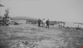
![Burrard Inlet, [1912] (date of original), copied 1986 thumbnail](/media/hpo/_Data/_Archives_Images/_Unrestricted/204/204-704.jpg?width=280)
Burrard Inlet
https://search.heritageburnaby.ca/link/archivedescription35845
- Repository
- City of Burnaby Archives
- Date
- [1912] (date of original), copied 1986
- Collection/Fonds
- Burnaby Historical Society fonds
- Description Level
- Item
- Physical Description
- 1 photograph : b&w ; 12.7 x 17.8 cm print
- Scope and Content
- Photograph of Burrard Inlet taken looking north from Capitol Hill.
- Repository
- City of Burnaby Archives
- Date
- [1912] (date of original), copied 1986
- Collection/Fonds
- Burnaby Historical Society fonds
- Subseries
- Pioneer Tales subseries
- Physical Description
- 1 photograph : b&w ; 12.7 x 17.8 cm print
- Description Level
- Item
- Record No.
- 204-704
- Access Restriction
- No restrictions
- Reproduction Restriction
- No known restrictions
- Accession Number
- BHS1988-03
- Scope and Content
- Photograph of Burrard Inlet taken looking north from Capitol Hill.
- Media Type
- Photograph
- Photographer
- Phillips, James William "Jim"
- Notes
- Title based on contents of photograph
- Historic Neighbourhood
- Capitol Hill (Historic Neighbourhood)
- Planning Study Area
- Capitol Hill Area
Images
![Burrard Inlet, [1912] (date of original), copied 1986 thumbnail](/media/hpo/_Data/_Archives_Images/_Unrestricted/204/204-704.jpg)

Camp at Oakalla Site
https://search.heritageburnaby.ca/link/archivedescription39575
- Repository
- City of Burnaby Archives
- Date
- 1910
- Collection/Fonds
- Peers Family and Hill Family fonds
- Description Level
- Item
- Physical Description
- 1 photograph : b&w ; 7.7 x 10.4 cm on page 21.5 x 28 cm (pasted in album)
- Scope and Content
- Photograph of the land clearing operation at the Oakalla Prison site in the Deer Lake area. Claude Hill is in the centre between two unidentified men. A line of clothes is hanging in the background.
- Repository
- City of Burnaby Archives
- Date
- 1910
- Collection/Fonds
- Peers Family and Hill Family fonds
- Physical Description
- 1 photograph : b&w ; 7.7 x 10.4 cm on page 21.5 x 28 cm (pasted in album)
- Description Level
- Item
- Record No.
- 477-894
- Access Restriction
- No restrictions
- Reproduction Restriction
- No known restrictions
- Accession Number
- 2007-12
- Scope and Content
- Photograph of the land clearing operation at the Oakalla Prison site in the Deer Lake area. Claude Hill is in the centre between two unidentified men. A line of clothes is hanging in the background.
- Subjects
- Land Clearing
- Media Type
- Photograph
- Notes
- Title based on contents of photograph
- Geographic Access
- Oakmount Crescent
- Street Address
- 5220 Oakmount Crescent
- Historic Neighbourhood
- Burnaby Lake (Historic Neighbourhood)
- Planning Study Area
- Oakalla Area
Images

Charles Street
https://search.heritageburnaby.ca/link/archivedescription34174
- Repository
- City of Burnaby Archives
- Date
- May 9, 1947
- Collection/Fonds
- Burnaby Historical Society fonds
- Description Level
- Item
- Physical Description
- 1 photograph : b&w negative ; 6.8 x 11.5 cm
- Scope and Content
- Photograph of cleared land and brush at the 4200 block of Charles Street. This is part of the Willingdon Heights subdivision site.
- Repository
- City of Burnaby Archives
- Date
- May 9, 1947
- Collection/Fonds
- Burnaby Historical Society fonds
- Subseries
- Alfred Bingham subseries
- Physical Description
- 1 photograph : b&w negative ; 6.8 x 11.5 cm
- Description Level
- Item
- Record No.
- 010-091
- Access Restriction
- No restrictions
- Reproduction Restriction
- No known restrictions
- Accession Number
- BHS2007-04
- Scope and Content
- Photograph of cleared land and brush at the 4200 block of Charles Street. This is part of the Willingdon Heights subdivision site.
- Subjects
- Land Clearing
- Media Type
- Photograph
- Photographer
- Bingham, Alfred "Alf"
- Notes
- Title based on contents of photograph
- Geographic Access
- Charles Street
Images
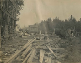
Cleared land
https://search.heritageburnaby.ca/link/archivedescription34216
- Repository
- City of Burnaby Archives
- Date
- June 29, 1947
- Collection/Fonds
- Burnaby Historical Society fonds
- Description Level
- Item
- Physical Description
- 1 photograph : b&w negative ; 6.8 x 11.3 cm
- Scope and Content
- Photograph of four men standing on a piece of cleared land with piles of lumber on either side of them. This is part of the Willingdon Heights subdivision site.
- Repository
- City of Burnaby Archives
- Date
- June 29, 1947
- Collection/Fonds
- Burnaby Historical Society fonds
- Subseries
- Alfred Bingham subseries
- Physical Description
- 1 photograph : b&w negative ; 6.8 x 11.3 cm
- Description Level
- Item
- Record No.
- 010-132
- Access Restriction
- No restrictions
- Reproduction Restriction
- Reproduce for fair dealing purposes only
- Accession Number
- BHS2007-04
- Scope and Content
- Photograph of four men standing on a piece of cleared land with piles of lumber on either side of them. This is part of the Willingdon Heights subdivision site.
- Subjects
- Industries - Construction
- Land Clearing
- Media Type
- Photograph
- Photographer
- Bingham, Alfred "Alf"
- Notes
- Title based on contents of photograph
Images


Clearing Gough Family Lot
https://search.heritageburnaby.ca/link/archivedescription35486
- Repository
- City of Burnaby Archives
- Date
- 1912 (date of original), copied 1986
- Collection/Fonds
- Burnaby Historical Society fonds
- Description Level
- Item
- Physical Description
- 1 photograph : b&w ; 12.7 x 17.8 cm print
- Scope and Content
- Photograph of the Gough family and relatives clearing the lot for the family home on Nelson Avenue, Alta Vista. Identified in the photo (back row, centre) Donald Gough. Others in picture are aunts and uncles named Evans. Donald was the son of Agnes Gough and her husband William, who settled here…
- Repository
- City of Burnaby Archives
- Date
- 1912 (date of original), copied 1986
- Collection/Fonds
- Burnaby Historical Society fonds
- Subseries
- Pioneer Tales subseries
- Physical Description
- 1 photograph : b&w ; 12.7 x 17.8 cm print
- Description Level
- Item
- Record No.
- 204-344
- Access Restriction
- No restrictions
- Reproduction Restriction
- No known restrictions
- Accession Number
- BHS1988-03
- Scope and Content
- Photograph of the Gough family and relatives clearing the lot for the family home on Nelson Avenue, Alta Vista. Identified in the photo (back row, centre) Donald Gough. Others in picture are aunts and uncles named Evans. Donald was the son of Agnes Gough and her husband William, who settled here at 2119 Nelson Avenue (later 7126 Nelson Avenue).
- Subjects
- Land Clearing
- Names
- Evans Family
- Gough, Donald
- Media Type
- Photograph
- Notes
- Title based on contents of photograph
- Annotation at top of photograph reads, "Nelson & Victory Sts - 1912"
- Geographic Access
- Nelson Avenue
- Street Address
- 7126 Nelson Avenue
- Historic Neighbourhood
- Alta-Vista (Historic Neighbourhood)
- Planning Study Area
- Sussex-Nelson Area
Images

![Clearing land, [1910 or 1911] thumbnail](/media/hpo/_Data/_Archives_Images/_Unrestricted/487/487-038.jpg?width=280)
Clearing land
https://search.heritageburnaby.ca/link/archivedescription65900
- Repository
- City of Burnaby Archives
- Date
- [1910 or 1911]
- Collection/Fonds
- J.W. Phillips fonds
- Description Level
- Item
- Physical Description
- 1 photograph : b&w glass negative ; 15.5 x 11 cm
- Scope and Content
- Photograph of three men clearing land (most likely) on the Phillips family property. John George "George" Phillips and his father William James Phillips appear to be standing on running boards at the base of a large felled tree. The third man, sitting at the base of the stump, is unidentified.
- Repository
- City of Burnaby Archives
- Date
- [1910 or 1911]
- Collection/Fonds
- J.W. Phillips fonds
- Physical Description
- 1 photograph : b&w glass negative ; 15.5 x 11 cm
- Material Details
- Emulsion measures 15.5 x 11 cm on the glass; entire glass plate measures 16 x 12 cm
- Description Level
- Item
- Record No.
- 487-038
- Access Restriction
- No restrictions
- Reproduction Restriction
- No known restrictions
- Accession Number
- 2008-18
- Scope and Content
- Photograph of three men clearing land (most likely) on the Phillips family property. John George "George" Phillips and his father William James Phillips appear to be standing on running boards at the base of a large felled tree. The third man, sitting at the base of the stump, is unidentified.
- Subjects
- Land Clearing
- Media Type
- Photograph
- Photographer
- Phillips, James William "Jim"
- Notes
- Title based on contents of photograph
- Geographic Access
- Ellesmere Avenue
- Historic Neighbourhood
- Capitol Hill (Historic Neighbourhood)
- Planning Study Area
- Capitol Hill Area
Images
![Clearing land, [1910 or 1911] thumbnail](/media/hpo/_Data/_Archives_Images/_Unrestricted/487/487-038.jpg)
![Clearing Land at Point Grey, [1911 or 1912] thumbnail](/media/hpo/_Data/_Archives_Images/_Unrestricted/371/413-001.jpg?width=280)
Clearing Land at Point Grey
https://search.heritageburnaby.ca/link/archivedescription38351
- Repository
- City of Burnaby Archives
- Date
- [1911 or 1912]
- Collection/Fonds
- Burnaby Historical Society fonds
- Description Level
- Item
- Physical Description
- 1 photograph : sepia ; 18.8 x 23.5 cm on 30.4 x 34.5 cm backing
- Scope and Content
- Photograph of eight men seated on a log in front of a large pile of trees and cleared debris in Vancouver, BC. A small shack is seen to the left and another man can be seen leaning against the doorway. A note indicates that T. Townley and W. Townley are two of the men pictured, but it does not ide…
- Repository
- City of Burnaby Archives
- Date
- [1911 or 1912]
- Collection/Fonds
- Burnaby Historical Society fonds
- Subseries
- Anne Sievenpiper subseries
- Physical Description
- 1 photograph : sepia ; 18.8 x 23.5 cm on 30.4 x 34.5 cm backing
- Description Level
- Item
- Record No.
- 413-001
- Access Restriction
- No restrictions
- Reproduction Restriction
- No known restrictions
- Accession Number
- BHS2001-02
- Scope and Content
- Photograph of eight men seated on a log in front of a large pile of trees and cleared debris in Vancouver, BC. A small shack is seen to the left and another man can be seen leaning against the doorway. A note indicates that T. Townley and W. Townley are two of the men pictured, but it does not identify specifically where they are seated nor the names of any of the other men.
- Names
- Townley, T.
- Townley, W.
- Media Type
- Photograph
- Photographer
- Bullen & Lamb
- Notes
- Title based on contents of photograph
Images
![Clearing Land at Point Grey, [1911 or 1912] thumbnail](/media/hpo/_Data/_Archives_Images/_Unrestricted/371/413-001.jpg)

Clearing Land for Oakalla Prison Farm
https://search.heritageburnaby.ca/link/archivedescription39574
- Repository
- City of Burnaby Archives
- Date
- 1910
- Collection/Fonds
- Peers Family and Hill Family fonds
- Description Level
- Item
- Physical Description
- 1 photograph : b&w ; 7.7 x 10.3 cm on page 21.5 x 28 cm (pasted in album)
- Scope and Content
- Photograph of the Oakalla Prison Farm site being cleared in the Deer Lake area. Claude Hill is to the far right but the other man is unidentified.
- Repository
- City of Burnaby Archives
- Date
- 1910
- Collection/Fonds
- Peers Family and Hill Family fonds
- Physical Description
- 1 photograph : b&w ; 7.7 x 10.3 cm on page 21.5 x 28 cm (pasted in album)
- Description Level
- Item
- Record No.
- 477-893
- Access Restriction
- No restrictions
- Reproduction Restriction
- No known restrictions
- Accession Number
- 2007-12
- Scope and Content
- Photograph of the Oakalla Prison Farm site being cleared in the Deer Lake area. Claude Hill is to the far right but the other man is unidentified.
- Subjects
- Land Clearing
- Media Type
- Photograph
- Notes
- Title based on contents of photograph
- Geographic Access
- Oakmount Crescent
- Street Address
- 5220 Oakmount Crescent
- Historic Neighbourhood
- Burnaby Lake (Historic Neighbourhood)
- Planning Study Area
- Oakalla Area
Images

Construction at the Oakalla Site
https://search.heritageburnaby.ca/link/archivedescription39580
- Repository
- City of Burnaby Archives
- Date
- 1910
- Collection/Fonds
- Peers Family and Hill Family fonds
- Description Level
- Item
- Physical Description
- 1 photograph : b&w ; 7.8 x 10 cm on page 21.5 x 28 cm (pasted in album)
- Scope and Content
- Photograph of construction work and land clearing at the site of the Oakalla Prison farm in the Deer Lake area. Three unidentified men can be seen standing in the background to the left.
- Repository
- City of Burnaby Archives
- Date
- 1910
- Collection/Fonds
- Peers Family and Hill Family fonds
- Physical Description
- 1 photograph : b&w ; 7.8 x 10 cm on page 21.5 x 28 cm (pasted in album)
- Description Level
- Item
- Record No.
- 477-899
- Access Restriction
- No restrictions
- Reproduction Restriction
- No known restrictions
- Accession Number
- 2007-12
- Scope and Content
- Photograph of construction work and land clearing at the site of the Oakalla Prison farm in the Deer Lake area. Three unidentified men can be seen standing in the background to the left.
- Subjects
- Construction
- Land Clearing
- Names
- Oakalla Prison Farm
- Media Type
- Photograph
- Notes
- Title based on contents of photograph
- Geographic Access
- Oakmount Crescent
- Street Address
- 5220 Oakmount Crescent
- Historic Neighbourhood
- Burnaby Lake (Historic Neighbourhood)
- Planning Study Area
- Oakalla Area
Images
