Narrow Results By
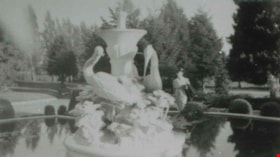
Fountain at Ocean View Cemetery
https://search.heritageburnaby.ca/link/archivedescription37829
- Repository
- City of Burnaby Archives
- Date
- 1944 (date of original), copied 1991
- Collection/Fonds
- Burnaby Historical Society fonds
- Description Level
- Item
- Physical Description
- 1 photograph : b&w ; 2.7 x 4.8 cm print on contact sheet 20.6 x 26.2 cm
- Scope and Content
- Photograph of a fountain in Ocean View Cemetery near Central Park. A woman is standing behind the fountain, and the design includes statues of birds.
- Repository
- City of Burnaby Archives
- Date
- 1944 (date of original), copied 1991
- Collection/Fonds
- Burnaby Historical Society fonds
- Subseries
- Burnaby Image Bank subseries
- Physical Description
- 1 photograph : b&w ; 2.7 x 4.8 cm print on contact sheet 20.6 x 26.2 cm
- Description Level
- Item
- Record No.
- 370-417
- Access Restriction
- No restrictions
- Reproduction Restriction
- No known restrictions
- Accession Number
- BHS1999-03
- Scope and Content
- Photograph of a fountain in Ocean View Cemetery near Central Park. A woman is standing behind the fountain, and the design includes statues of birds.
- Subjects
- Cemeteries
- Fountains
- Names
- Ocean View Burial Park
- Media Type
- Photograph
- Notes
- Title based on contents of photograph
- 1 b&w copy negative accompanying
- Negative has a pink cast
- Geographic Access
- Imperial Street
- Street Address
- 4000 Imperial Street
- Historic Neighbourhood
- Alta-Vista (Historic Neighbourhood)
- Planning Study Area
- Suncrest Area
Images


Plan of Subdivision of Lot 14 of North part of NW 1/4 of D.L. 150 GR.1 N.W.D
https://search.heritageburnaby.ca/link/museumdescription11117
- Repository
- Burnaby Village Museum
- Date
- 1912
- Collection/Fonds
- Ronald G. Scobbie collection
- Description Level
- Item
- Physical Description
- 2 plans : ink on linen + blueprint ; 21.5 x 27.5 cm
- Scope and Content
- File consists of "Plan of Subdivision of Lot 14 of North / Part of N.W. 1/4 of D.L. 150, GR.1. / N.W.D." and blueprint of same.
- Repository
- Burnaby Village Museum
- Collection/Fonds
- Ronald G. Scobbie collection
- Description Level
- Item
- Physical Description
- 2 plans : ink on linen + blueprint ; 21.5 x 27.5 cm
- Material Details
- Scale [1:1200]
- Scope and Content
- File consists of "Plan of Subdivision of Lot 14 of North / Part of N.W. 1/4 of D.L. 150, GR.1. / N.W.D." and blueprint of same.
- Creator
- Hill & Burnett
- Geographic Access
- Jubilee Avenue
- Accession Code
- HV984.57.10
- Access Restriction
- No restrictions
- Reproduction Restriction
- No known restrictions
- Date
- 1912
- Media Type
- Cartographic Material
- Planning Study Area
- Suncrest Area
- Scan Resolution
- 600
- Scan Date
- 2-Oct-19
- Scale
- 100
- Notes
- Transcribed title
- Notes in red crayon on verso of both plans read: "00079"
- Oval shaped stamp in blue ink on front of blueprint plan reads: "Corporation of Burnaby / Feb. 2 1912 / Engineering Department"
- Stamp in red ink on verso of Blueprint plan reads: "Hill & Burnett / Civil Engineers / B.C. Land Surveyors / New Westminster B.C."
- Handwritten note on front of blueprint plan reads: "T... [sic] approved / subject to 20' Laws [sic] / being given. / Fred L. Macpherson / Engineer / Feb. 6th 1912"
Images


![Proposed subdivision of D.L. 150, Grp. 1, [1912] thumbnail](/media/hpo/_Data/_BVM_Cartographic_Material/1984/1984_0057_0011_001.jpg?width=280)
Proposed subdivision of D.L. 150, Grp. 1
https://search.heritageburnaby.ca/link/museumdescription11118
- Repository
- Burnaby Village Museum
- Date
- [1912]
- Collection/Fonds
- Ronald G. Scobbie collection
- Description Level
- Item
- Physical Description
- 1 plan : pencil and ink on paper ; 34 x 21 cm
- Scope and Content
- Item consists of a handrawn draft subdivision plan for District Lot 150, Group 1. Plan identifies streets running east off Boundary Road including Dubois; Hurst; Victory and Cade
- Repository
- Burnaby Village Museum
- Collection/Fonds
- Ronald G. Scobbie collection
- Description Level
- Item
- Physical Description
- 1 plan : pencil and ink on paper ; 34 x 21 cm
- Scope and Content
- Item consists of a handrawn draft subdivision plan for District Lot 150, Group 1. Plan identifies streets running east off Boundary Road including Dubois; Hurst; Victory and Cade
- Accession Code
- HV984.57.11
- Access Restriction
- No restrictions
- Reproduction Restriction
- No known restrictions
- Date
- [1912]
- Media Type
- Cartographic Material
- Planning Study Area
- Suncrest Area
- Scan Resolution
- 600
- Scan Date
- April 14, 2021
- Scale
- 100
- Notes
- Title based on contents of plan
Images
![Proposed subdivision of D.L. 150, Grp. 1, [1912] thumbnail](/media/hpo/_Data/_BVM_Cartographic_Material/1984/1984_0057_0011_001.jpg)
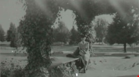
Woman in Ocean View Cemetery
https://search.heritageburnaby.ca/link/archivedescription37830
- Repository
- City of Burnaby Archives
- Date
- 1944 (date of original), copied 1991
- Collection/Fonds
- Burnaby Historical Society fonds
- Description Level
- Item
- Physical Description
- 1 photograph : b&w ; 2.7 x 4.8 cm print on contact sheet 20.6 x 26.2 cm
- Scope and Content
- Photograph of an unidentified woman sitting just inside the gates of Ocean View Cemetery near Central Park.
- Repository
- City of Burnaby Archives
- Date
- 1944 (date of original), copied 1991
- Collection/Fonds
- Burnaby Historical Society fonds
- Subseries
- Burnaby Image Bank subseries
- Physical Description
- 1 photograph : b&w ; 2.7 x 4.8 cm print on contact sheet 20.6 x 26.2 cm
- Description Level
- Item
- Record No.
- 370-418
- Access Restriction
- No restrictions
- Reproduction Restriction
- No known restrictions
- Accession Number
- BHS1999-03
- Scope and Content
- Photograph of an unidentified woman sitting just inside the gates of Ocean View Cemetery near Central Park.
- Subjects
- Cemeteries
- Names
- Ocean View Burial Park
- Media Type
- Photograph
- Notes
- Title based on contents of photograph
- 1 b&w copy negative accompanying
- Negative has a pink cast
- Geographic Access
- Imperial Street
- Street Address
- 4000 Imperial Street
- Historic Neighbourhood
- Alta-Vista (Historic Neighbourhood)
- Planning Study Area
- Suncrest Area
Images
