Narrow Results By

Isaiah Poirier Residence
https://search.heritageburnaby.ca/link/landmark597
- Repository
- Burnaby Heritage Planning
- Description
- Residential building.
- Associated Dates
- 1912
- Street View URL
- Google Maps Street View
- Repository
- Burnaby Heritage Planning
- Geographic Access
- Claude Avenue
- Associated Dates
- 1912
- Description
- Residential building.
- Heritage Value
- This front gabled residence is characteristic of workers houses from the Edwardian era. One of the oldest houses in this area, it retains numerous original architectural elements such as its double-hung windows with multi-paned upper sashes, triangular eave brackets and a glazed front door with applied ornamentation. It was built for Isaiah Poirier in a subdivision that was created adjacent to the Rayside station of the Burnaby Lake interurban line of the B.C. Electric Railway.
- Locality
- Burnaby Lake
- Historic Neighbourhood
- Burnaby Lake (Historic Neighbourhood)
- Planning Study Area
- Morley-Buckingham Area
- Area
- 748.06
- Contributing Resource
- Building
- Ownership
- Private
- Street Address
- 5551 Claude Avenue
- Street View URL
- Google Maps Street View
Images

![Blacksmith on Lubbock Farm, [194-] (date of original), copied 1986 thumbnail](/media/hpo/_Data/_Archives_Images/_Unrestricted/204/204-724.jpg?width=280)
Blacksmith on Lubbock Farm
https://search.heritageburnaby.ca/link/archivedescription35865
- Repository
- City of Burnaby Archives
- Date
- [194-] (date of original), copied 1986
- Collection/Fonds
- Burnaby Historical Society fonds
- Description Level
- Item
- Physical Description
- 1 photograph : b&w ; 12.7 x 17.8 cm print
- Scope and Content
- Photograph of John Lubbock working as the farm blacksmith on the Lubbock farm.
- Repository
- City of Burnaby Archives
- Date
- [194-] (date of original), copied 1986
- Collection/Fonds
- Burnaby Historical Society fonds
- Subseries
- Pioneer Tales subseries
- Physical Description
- 1 photograph : b&w ; 12.7 x 17.8 cm print
- Description Level
- Item
- Record No.
- 204-724
- Access Restriction
- No restrictions
- Reproduction Restriction
- Reproduce for fair dealing purposes only
- Accession Number
- BHS1988-03
- Scope and Content
- Photograph of John Lubbock working as the farm blacksmith on the Lubbock farm.
- Subjects
- Occupations - Blacksmiths
- Names
- Lubbock, John
- Media Type
- Photograph
- Notes
- Title based on contents of photograph.
- A note with this photograph indicated the old address of the farm was 1 Arbor Lane.
- Geographic Access
- Grandview Highway
- Canada Way
- Burris Street
- Street Address
- 7803 Burris Street
- Historic Neighbourhood
- Burnaby Lake (Historic Neighbourhood)
- Planning Study Area
- Morley-Buckingham Area
Images
![Blacksmith on Lubbock Farm, [194-] (date of original), copied 1986 thumbnail](/media/hpo/_Data/_Archives_Images/_Unrestricted/204/204-724.jpg)
Lubbock photographs from album
https://search.heritageburnaby.ca/link/archivedescription64493
- Repository
- City of Burnaby Archives
- Date
- 1945-1988
- Collection/Fonds
- Burnaby Historical Society fonds
- Description Level
- File
- Physical Description
- 130 photographs : b&w and col. ; 20.5 x 25.5 cm or smaller
- Scope and Content
- Photographs of the Lubbock family, including their riding stables and horses, family events, their pets, and landscape and travel photographs. These photographs were originally housed in a photographic album.
- Repository
- City of Burnaby Archives
- Date
- 1945-1988
- Collection/Fonds
- Burnaby Historical Society fonds
- Subseries
- Lubbock family subseries
- Physical Description
- 130 photographs : b&w and col. ; 20.5 x 25.5 cm or smaller
- Description Level
- File
- Record No.
- 342-046
- Access Restriction
- In Archives only
- Reproduction Restriction
- May be restricted by third party rights
- Accession Number
- BHS1994-02
- Scope and Content
- Photographs of the Lubbock family, including their riding stables and horses, family events, their pets, and landscape and travel photographs. These photographs were originally housed in a photographic album.
- Names
- Lubbock, Ainsly
- Lubbock, Beatrice "Bea"
- Lubbock, Elizabeth
- Lubbock, Gordon
- Lubbock, John
- Lubbock, John Barker
- Lubbock, Mina
- Media Type
- Photograph
- Notes
- Title based on contents of photograph
- Geographic Access
- Grandview Highway
- Canada Way
- Burris Street
- Street Address
- 7803 Burris Street
- Historic Neighbourhood
- Burnaby Lake (Historic Neighbourhood)
- Planning Study Area
- Morley-Buckingham Area
Rowe Ranch
https://search.heritageburnaby.ca/link/archivedescription36022
- Repository
- City of Burnaby Archives
- Date
- 1911
- Collection/Fonds
- Burnaby Historical Society fonds
- Description Level
- Item
- Physical Description
- 1 photograph : sepia ; 5 x 14 cm
- Scope and Content
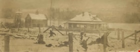
- Photograph of Rowe Ranch, on Burnaby Lake, at the foot of Burris Street. The lake is covered in snow and ice.
- Repository
- City of Burnaby Archives
- Date
- 1911
- Collection/Fonds
- Burnaby Historical Society fonds
- Subseries
- Patterson family subseries
- Physical Description
- 1 photograph : sepia ; 5 x 14 cm
- Description Level
- Item
- Record No.
- 213-004
- Access Restriction
- No restrictions
- Reproduction Restriction
- No known restrictions
- Accession Number
- BHS1988-13
- Scope and Content
- Photograph of Rowe Ranch, on Burnaby Lake, at the foot of Burris Street. The lake is covered in snow and ice.
- Subjects
- Geographic Features - Lakes and Ponds
- Natural Phenomena - Snow
- Buildings - Residential - Houses
- Media Type
- Photograph
- Notes
- Title based on contents of photograph
- Handwritten note on verso of photograph reads: "Bruce and Bill found a deer frozen in Burnaby lake in the ice".
- Geographic Access
- Burnaby Lake
- Burris Street
- Historic Neighbourhood
- Burnaby Lake (Historic Neighbourhood)
- Planning Study Area
- Burnaby Lake Area
Images
![Sperling Avenue near Burris Street, [1946 or 1947] (date of original), copied 1991 thumbnail](/media/hpo/_Data/_Archives_Images/_Unrestricted/370/370-529.jpg?width=280)
Sperling Avenue near Burris Street
https://search.heritageburnaby.ca/link/archivedescription37942
- Repository
- City of Burnaby Archives
- Date
- [1946 or 1947] (date of original), copied 1991
- Collection/Fonds
- Burnaby Historical Society fonds
- Description Level
- Item
- Physical Description
- 1 photograph : b&w ; 3.5 x 4.4 cm print on contact sheet 20.5 x 26.7 cm
- Scope and Content
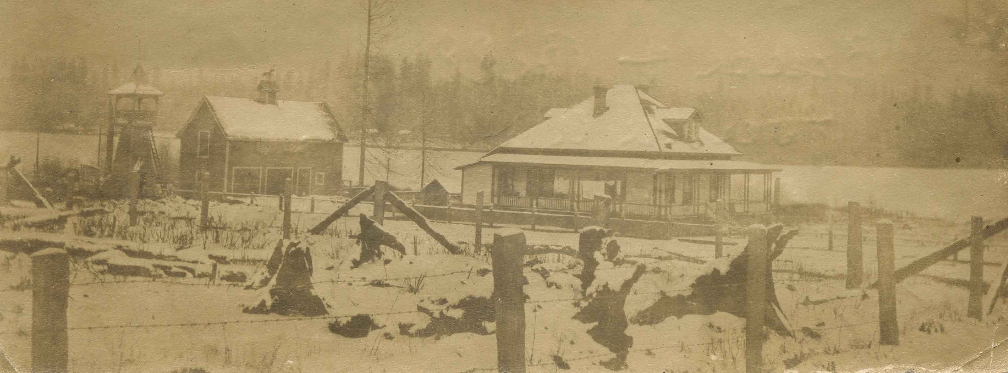
- Photograph of Sperling Avenue near Burris Street in the snow. Burnaby United Church is the second building from the right. The photograph was taken facing northwest.
- Repository
- City of Burnaby Archives
- Date
- [1946 or 1947] (date of original), copied 1991
- Collection/Fonds
- Burnaby Historical Society fonds
- Subseries
- Burnaby Image Bank subseries
- Physical Description
- 1 photograph : b&w ; 3.5 x 4.4 cm print on contact sheet 20.5 x 26.7 cm
- Description Level
- Item
- Record No.
- 370-529
- Access Restriction
- No restrictions
- Reproduction Restriction
- No known restrictions
- Accession Number
- BHS1999-03
- Scope and Content
- Photograph of Sperling Avenue near Burris Street in the snow. Burnaby United Church is the second building from the right. The photograph was taken facing northwest.
- Names
- Burnaby United Church
- Media Type
- Photograph
- Notes
- Title based on contents of photograph
- 1 b&w copy negative accompanying
- Negative has a pink cast
- Geographic Access
- Sperling Avenue
- Burris Street
- Historic Neighbourhood
- Burnaby Lake (Historic Neighbourhood)
- Planning Study Area
- Morley-Buckingham Area
Images
![Sperling Avenue near Burris Street, [1946 or 1947] (date of original), copied 1991 thumbnail](/media/hpo/_Data/_Archives_Images/_Unrestricted/370/370-529.jpg)