Narrow Results By
Subject
- Advertising Medium - Signs and Signboards 1
- Aerial Photographs 2
- Animals - Birds 2
- Animals - Cows 1
- Animals - Dogs 1
- Animals - Poultry 1
- Buildings - Agricultural - Greenhouses 1
- Buildings - Commercial - Grocery Stores 3
- Buildings - Commercial - Restaurants 1
- Buildings - Heritage 20
- Buildings - Residences - Houses 1
- Buildings - Residential - Houses 12
Creator
- Burnaby Village Museum 1
- Burnett, Geoffrey K. 3
- Burnett & McGugan, Engineers and Surveyors 1
- Disney, John Harold "Jack" 4
- Garden, Hermon and Burwell 1
- Leibly & Blumer Realty Co. Incorporated 1
- Moore, Godfrey 1
- Neonette Sign Company 1
- Parker, Albert "Bert" 14
- Petrusa, Kate 1
- Province of British Columbia 2
- Stenton, Harry Royal 1
![At Buena Vista, [between 1912 and 1925] thumbnail](/media/hpo/_Data/_BVM_Images/1984/1984_0051_0032_001.jpg?width=280)
At Buena Vista
https://search.heritageburnaby.ca/link/museumdescription260
- Repository
- Burnaby Village Museum
- Date
- [between 1912 and 1925]
- Collection/Fonds
- Burnaby Village Museum Photograph collection
- Description Level
- Item
- Physical Description
- 1 photograph : b&w ; 3.5 x 7.0 cm
- Scope and Content
- Photograph of a woman with short dark hair wearing a white blouse, sitting on the steps of a house. According to the accession register, the location of the house is at Buena Vista, Burnaby, between 1912 and 1925.
- Repository
- Burnaby Village Museum
- Collection/Fonds
- Burnaby Village Museum Photograph collection
- Description Level
- Item
- Physical Description
- 1 photograph : b&w ; 3.5 x 7.0 cm
- Scope and Content
- Photograph of a woman with short dark hair wearing a white blouse, sitting on the steps of a house. According to the accession register, the location of the house is at Buena Vista, Burnaby, between 1912 and 1925.
- Accession Code
- HV984.51.32
- Access Restriction
- No restrictions
- Reproduction Restriction
- No known restrictions
- Date
- [between 1912 and 1925]
- Media Type
- Photograph
- Historic Neighbourhood
- East Burnaby (Historic Neighbourhood)
- Planning Study Area
- Cariboo-Armstrong Area
- Scan Resolution
- 600
- Scan Date
- 2023-10-10
- Notes
- Title based on contents of photograph
Images
![At Buena Vista, [between 1912 and 1925] thumbnail](/media/hpo/_Data/_BVM_Images/1984/1984_0051_0032_001.jpg)
![Avaries and fish pond, [between 1939 and 1940] (date of original), copied 2014 thumbnail](/media/hpo/_Data/_Archives_Images/_Unrestricted/580/581-003.jpg?width=280)
Avaries and fish pond
https://search.heritageburnaby.ca/link/archivedescription88397
- Repository
- City of Burnaby Archives
- Date
- [between 1939 and 1940] (date of original), copied 2014
- Collection/Fonds
- James Massey family fonds
- Description Level
- Item
- Physical Description
- 1 photograph (tiff) : sepia ; 600 dpi
- Scope and Content
- Photograph of two avaries which held canaries and a fish pond in Robert Burnaby Park. James Massey was the caretaker of the park and built the fish pond in 1939 and three avaries where he raised canaries.
- Repository
- City of Burnaby Archives
- Date
- [between 1939 and 1940] (date of original), copied 2014
- Collection/Fonds
- James Massey family fonds
- Physical Description
- 1 photograph (tiff) : sepia ; 600 dpi
- Description Level
- Item
- Record No.
- 581-003
- Access Restriction
- No restrictions
- Reproduction Restriction
- No known restrictions
- Accession Number
- 2014-34
- Scope and Content
- Photograph of two avaries which held canaries and a fish pond in Robert Burnaby Park. James Massey was the caretaker of the park and built the fish pond in 1939 and three avaries where he raised canaries.
- Media Type
- Photograph
- Notes
- Title based on contents of photograph
- Historic Neighbourhood
- East Burnaby (Historic Neighbourhood)
- Planning Study Area
- Lakeview-Mayfield Area
Images
![Avaries and fish pond, [between 1939 and 1940] (date of original), copied 2014 thumbnail](/media/hpo/_Data/_Archives_Images/_Unrestricted/580/581-003.jpg)
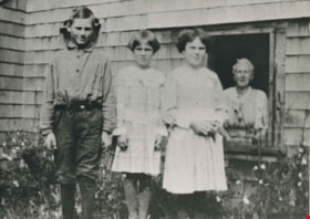
Beamish family
https://search.heritageburnaby.ca/link/archivedescription35641
- Repository
- City of Burnaby Archives
- Date
- 1919 (date of original), copied 1986
- Collection/Fonds
- Burnaby Historical Society fonds
- Description Level
- Item
- Physical Description
- 1 photograph : b&w ; 12.7 x 17.8 cm print
- Scope and Content
- Photograph of the Beamish family.William Randolph "Ran" Beamish (long-time Reeve of Burnaby later on); Ilma Beatrice Beamish (sister); Ethel Agnes Beamish (sister); (in window in background) Mrs. Agnes Beamish (mother). The photograph was taken in front of the family home at 277 17th Avenue (later …
- Repository
- City of Burnaby Archives
- Date
- 1919 (date of original), copied 1986
- Collection/Fonds
- Burnaby Historical Society fonds
- Subseries
- Pioneer Tales subseries
- Physical Description
- 1 photograph : b&w ; 12.7 x 17.8 cm print
- Description Level
- Item
- Record No.
- 204-499
- Access Restriction
- No restrictions
- Reproduction Restriction
- No known restrictions
- Accession Number
- BHS1988-03
- Scope and Content
- Photograph of the Beamish family.William Randolph "Ran" Beamish (long-time Reeve of Burnaby later on); Ilma Beatrice Beamish (sister); Ethel Agnes Beamish (sister); (in window in background) Mrs. Agnes Beamish (mother). The photograph was taken in front of the family home at 277 17th Avenue (later renumbered 8059 17th Avenue) in East Burnaby.
- Subjects
- Officials - Mayors and Reeves
- Media Type
- Photograph
- Notes
- Title based on contents of photograph
- Geographic Access
- 17th Avenue
- Street Address
- 8059 17th Avenue
- Historic Neighbourhood
- East Burnaby (Historic Neighbourhood)
- Planning Study Area
- Second Street Area
Images


Beamish family
https://search.heritageburnaby.ca/link/museumdescription1206
- Repository
- Burnaby Village Museum
- Date
- 1919
- Collection/Fonds
- Burnaby Village Museum Photograph collection
- Description Level
- Item
- Physical Description
- 1 photograph : b&w ; 11.5 x 16. 5 cm print
- Scope and Content
- Photograph of the Beamish family; ten year old Randolph, seven year old Ilma (later Dunn) and nine year old Ethel (later Derrick) standing in a row outside their family home at 277 17th Avenue (later renumbered 8059 17th Avenue). Agnes Beamish is at the far right looking out the pantry window from …
- Repository
- Burnaby Village Museum
- Collection/Fonds
- Burnaby Village Museum Photograph collection
- Description Level
- Item
- Physical Description
- 1 photograph : b&w ; 11.5 x 16. 5 cm print
- Scope and Content
- Photograph of the Beamish family; ten year old Randolph, seven year old Ilma (later Dunn) and nine year old Ethel (later Derrick) standing in a row outside their family home at 277 17th Avenue (later renumbered 8059 17th Avenue). Agnes Beamish is at the far right looking out the pantry window from inside the house.
- Geographic Access
- 17th Avenue
- Street Address
- 8059 17th Avenue
- Accession Code
- BV995.17.6
- Access Restriction
- No restrictions
- Reproduction Restriction
- No known restrictions
- Date
- 1919
- Media Type
- Photograph
- Historic Neighbourhood
- East Burnaby (Historic Neighbourhood)
- Planning Study Area
- Second Street Area
- Scan Resolution
- 600
- Scan Date
- 07-May-24
- Notes
- Title based on contents of photograph
- Note on verso of photograph reads: "Summer of 1919 Randolph 10 / Ethel 9 / Ilma 7 /The Beamish children with Mother at Pantry Window"
Images


Beamish family
https://search.heritageburnaby.ca/link/museumdescription1207
- Repository
- Burnaby Village Museum
- Date
- 1919
- Collection/Fonds
- Burnaby Village Museum Photograph collection
- Description Level
- Item
- Physical Description
- 1 photograph : b&w ; 12.5 x 18 cm print
- Scope and Content
- Photograph of the Beamish family standing in front of their family home at 277 17th Avenue. From left to right, they are; Randolph, Ilma (later Dunn) , Ethel (later Derrick) and their parents Agnes and William John Beamish.
- Repository
- Burnaby Village Museum
- Collection/Fonds
- Burnaby Village Museum Photograph collection
- Description Level
- Item
- Physical Description
- 1 photograph : b&w ; 12.5 x 18 cm print
- Scope and Content
- Photograph of the Beamish family standing in front of their family home at 277 17th Avenue. From left to right, they are; Randolph, Ilma (later Dunn) , Ethel (later Derrick) and their parents Agnes and William John Beamish.
- Names
- Beamish, Agnes
- Beamish, William Randolph "Ran"
- Dunn, Ilma Beamish
- Derrick, Ethel Beamish
- Beamish, William John
- Geographic Access
- 17th Avenue
- Street Address
- 8059 17th Avenue
- Accession Code
- BV995.17.7
- Access Restriction
- No restrictions
- Reproduction Restriction
- No known restrictions
- Date
- 1919
- Media Type
- Photograph
- Historic Neighbourhood
- East Burnaby (Historic Neighbourhood)
- Planning Study Area
- Second Street Area
- Scan Resolution
- 600
- Scan Date
- 07-May-24
- Notes
- Title based on contents of photograph
- Note on verso of photograph reads: "The BEAMISH HOME on 17th Ave. and The Family - 1919"
Images

![Bird aviary, [between 1939 and 1940] (date of original), copied 2014 thumbnail](/media/hpo/_Data/_Archives_Images/_Unrestricted/580/581-005.jpg?width=280)
Bird aviary
https://search.heritageburnaby.ca/link/archivedescription88399
- Repository
- City of Burnaby Archives
- Date
- [between 1939 and 1940] (date of original), copied 2014
- Collection/Fonds
- James Massey family fonds
- Description Level
- Item
- Physical Description
- 1 photograph (tiff) : sepia ; 600 dpi
- Scope and Content
- Photograph of a bird aviary in Robert Burnaby Park. The bird aviary was built for raisng canaries by James Massey who was the caretaker of the park from 1933 until 1947.
- Repository
- City of Burnaby Archives
- Date
- [between 1939 and 1940] (date of original), copied 2014
- Collection/Fonds
- James Massey family fonds
- Physical Description
- 1 photograph (tiff) : sepia ; 600 dpi
- Description Level
- Item
- Record No.
- 581-005
- Access Restriction
- No restrictions
- Reproduction Restriction
- No known restrictions
- Accession Number
- 2014-34
- Scope and Content
- Photograph of a bird aviary in Robert Burnaby Park. The bird aviary was built for raisng canaries by James Massey who was the caretaker of the park from 1933 until 1947.
- Media Type
- Photograph
- Notes
- Title based on contents of photograph
- Historic Neighbourhood
- East Burnaby (Historic Neighbourhood)
- Planning Study Area
- Lakeview-Mayfield Area
Images
![Bird aviary, [between 1939 and 1940] (date of original), copied 2014 thumbnail](/media/hpo/_Data/_Archives_Images/_Unrestricted/580/581-005.jpg)
![Bird's eye view of New Westminster, Burnaby and Vancouver, [ca. 1911] thumbnail](/media/hpo/_Data/_BVM_Cartographic_Material/1983/1983_0012_0001_002%20Web.jpg?width=280)
Bird's eye view of New Westminster, Burnaby and Vancouver
https://search.heritageburnaby.ca/link/museumdescription8199
- Repository
- Burnaby Village Museum
- Date
- [ca. 1911]
- Collection/Fonds
- Burnaby Village Museum Map collection
- Description Level
- Item
- Physical Description
- 1 map : hand painted ; 65.5 x 99 cm
- Scope and Content
- An untitled monochromatic grayscale map of a developer's bird's eye view looking north west from Burnaby Mountain. View includes Burnaby, New Westminster, Vancouver with the North shore in the distance. Burnaby neighbourhood subdivisions of "Burnaby Heights" and "Buena Vista" are featured near the…
- Repository
- Burnaby Village Museum
- Collection/Fonds
- Burnaby Village Museum Map collection
- Description Level
- Item
- Physical Description
- 1 map : hand painted ; 65.5 x 99 cm
- Scope and Content
- An untitled monochromatic grayscale map of a developer's bird's eye view looking north west from Burnaby Mountain. View includes Burnaby, New Westminster, Vancouver with the North shore in the distance. Burnaby neighbourhood subdivisions of "Burnaby Heights" and "Buena Vista" are featured near the centre of the map. These neighbourhood subdivisions were marketed by Real Estate Agents Liebly & Blumer in 1911. Roads, buildings, factories, railways and bridges are identified on the map.
- Subjects
- Businesses - Real Estate Agencies
- Responsibility
- Leibly & Blumer Realty Co. Incorporated
- Accession Code
- HV983.12.1
- Access Restriction
- No restrictions
- Reproduction Restriction
- No known restrictions
- Date
- [ca. 1911]
- Media Type
- Cartographic Material
- Historic Neighbourhood
- East Burnaby (Historic Neighbourhood)
- Vancouver Heights (Historic Neighbourhood)
- Planning Study Area
- Cariboo-Armstrong Area
- Burnaby Heights Area
- Scan Resolution
- 300
- Scan Date
- December 2020
- Scale
- 100
- Notes
- Title based on contents of map
- Note in pencil on verso of photograph reads: "Make tint block of Buena Vista / Blocks only as shown in lots"
Zoomable Images
![Bird's eye view of New Westminster, Burnaby and Vancouver, [ca. 1911] thumbnail](/media/hpo/_Data/_BVM_Cartographic_Material/1983/1983_0012_0001_001_seadragon/1983_0012_0001_001.jpg?w=280)
![Bob Love, [191-] thumbnail](/media/hpo/_Data/_BVM_Images/2022/2022_0032_0134_001.jpg?width=280)
Bob Love
https://search.heritageburnaby.ca/link/museumdescription19712
- Repository
- Burnaby Village Museum
- Date
- [191-]
- Collection/Fonds
- Esther Love Stanley fonds
- Description Level
- Item
- Physical Description
- 1 photograph : b&w ; 10.5 x 8 cm
- Scope and Content
- Photograph of Thomas Robert "Bob" Love, standing in an orchard at the Love family home at 1390 Cumberland Road. Bob's right arm is bent with his hand on his waist. He is wearing a white collared shirt with tie, dark pants, belt and suspenders. Orchard trees in full leaf are in background. Bob Love…
- Repository
- Burnaby Village Museum
- Collection/Fonds
- Esther Love Stanley fonds
- Description Level
- Item
- Physical Description
- 1 photograph : b&w ; 10.5 x 8 cm
- Scope and Content
- Photograph of Thomas Robert "Bob" Love, standing in an orchard at the Love family home at 1390 Cumberland Road. Bob's right arm is bent with his hand on his waist. He is wearing a white collared shirt with tie, dark pants, belt and suspenders. Orchard trees in full leaf are in background. Bob Love served in World War 1 and died at the age of 31 years on November 23, 1918.
- Geographic Access
- Cumberland Street
- Street Address
- 7651 Cumberland Street
- Accession Code
- BV022.32.134
- Access Restriction
- No restrictions
- Reproduction Restriction
- No known restrictions
- Date
- [191-]
- Media Type
- Photograph
- Historic Neighbourhood
- East Burnaby (Historic Neighbourhood)
- Planning Study Area
- Cariboo-Armstrong Area
- Related Material
- See also BV022.32.514
- Scan Resolution
- 600
- Scan Date
- 2023-04-04
- Notes
- Title based on contents of photograph
- Photograph is part of Esther Love Stanley photograph album 1 (BV022.32.1)
Images
![Bob Love, [191-] thumbnail](/media/hpo/_Data/_BVM_Images/2022/2022_0032_0134_001.jpg)
![Bob Love on porch, [191-] thumbnail](/media/hpo/_Data/_BVM_Images/2022/2022_0032_0162_001.jpg?width=280)
Bob Love on porch
https://search.heritageburnaby.ca/link/museumdescription19740
- Repository
- Burnaby Village Museum
- Date
- [191-]
- Collection/Fonds
- Esther Love Stanley fonds
- Description Level
- Item
- Physical Description
- 1 photograph : b&w ; 8 x 10.5 cm
- Scope and Content
- Photograph of Thomas Robert "Bob" Love standing on the front porch of the Love family home on Cumberland Road.
- Repository
- Burnaby Village Museum
- Collection/Fonds
- Esther Love Stanley fonds
- Description Level
- Item
- Physical Description
- 1 photograph : b&w ; 8 x 10.5 cm
- Scope and Content
- Photograph of Thomas Robert "Bob" Love standing on the front porch of the Love family home on Cumberland Road.
- Geographic Access
- Cumberland Street
- Street Address
- 7651 Cumberland Street
- Accession Code
- BV022.32.162
- Access Restriction
- No restrictions
- Reproduction Restriction
- No known restrictions
- Date
- [191-]
- Media Type
- Photograph
- Historic Neighbourhood
- East Burnaby (Historic Neighbourhood)
- Planning Study Area
- Cariboo-Armstrong Area
- Scan Resolution
- 600
- Scan Date
- 2023-04-04
- Notes
- Title based on contents of photograph
- Photograph is part of Esther Love Stanley photograph album 1 (BV022.32.1)
- Annotation in white on album page reads: "Bob"
Images
![Bob Love on porch, [191-] thumbnail](/media/hpo/_Data/_BVM_Images/2022/2022_0032_0162_001.jpg)
![Bob or Henry Love on porch, [191-] thumbnail](/media/hpo/_Data/_BVM_Images/2022/2022_0032_0154_001.jpg?width=280)
Bob or Henry Love on porch
https://search.heritageburnaby.ca/link/museumdescription19732
- Repository
- Burnaby Village Museum
- Date
- [191-]
- Collection/Fonds
- Esther Love Stanley fonds
- Description Level
- Item
- Physical Description
- 1 photograph : b&w ; 10.5 x 8 cm
- Scope and Content
- Photograph of Henry or Bob Love standing on the front porch of the Love family home on Cumberland Road.
- Repository
- Burnaby Village Museum
- Collection/Fonds
- Esther Love Stanley fonds
- Description Level
- Item
- Physical Description
- 1 photograph : b&w ; 10.5 x 8 cm
- Scope and Content
- Photograph of Henry or Bob Love standing on the front porch of the Love family home on Cumberland Road.
- Geographic Access
- Cumberland Street
- Street Address
- 7651 Cumberland Street
- Accession Code
- BV022.32.154
- Access Restriction
- No restrictions
- Reproduction Restriction
- No known restrictions
- Date
- [191-]
- Media Type
- Photograph
- Historic Neighbourhood
- East Burnaby (Historic Neighbourhood)
- Planning Study Area
- Cariboo-Armstrong Area
- Scan Resolution
- 600
- Scan Date
- 2023-04-04
- Notes
- Title based on contents of photograph
- Photograph is part of Esther Love Stanley photograph album 1 (BV022.32.1)
Images
![Bob or Henry Love on porch, [191-] thumbnail](/media/hpo/_Data/_BVM_Images/2022/2022_0032_0154_001.jpg)
![Bridge and trail in Robert Burnaby Park, [between 1933 and 1947] (date of original), copied 2014 thumbnail](/media/hpo/_Data/_Archives_Images/_Unrestricted/580/581-012.jpg?width=280)
Bridge and trail in Robert Burnaby Park
https://search.heritageburnaby.ca/link/archivedescription88406
- Repository
- City of Burnaby Archives
- Date
- [between 1933 and 1947] (date of original), copied 2014
- Collection/Fonds
- James Massey family fonds
- Description Level
- Item
- Physical Description
- 1 photograph (tiff) : sepia ; 600 dpi
- Scope and Content
- Photograph of a trail in Robert Burnaby Park with a bridge in the middle ground and stairs leading to higher ground. The bridge and trail are surrounded by lush foliage and trees.
- Repository
- City of Burnaby Archives
- Date
- [between 1933 and 1947] (date of original), copied 2014
- Collection/Fonds
- James Massey family fonds
- Physical Description
- 1 photograph (tiff) : sepia ; 600 dpi
- Description Level
- Item
- Record No.
- 581-012
- Access Restriction
- No restrictions
- Reproduction Restriction
- No known restrictions
- Accession Number
- 2014-34
- Scope and Content
- Photograph of a trail in Robert Burnaby Park with a bridge in the middle ground and stairs leading to higher ground. The bridge and trail are surrounded by lush foliage and trees.
- Media Type
- Photograph
- Notes
- Title based on contents of photograph
- Historic Neighbourhood
- East Burnaby (Historic Neighbourhood)
- Planning Study Area
- Lakeview-Mayfield Area
Images
![Bridge and trail in Robert Burnaby Park, [between 1933 and 1947] (date of original), copied 2014 thumbnail](/media/hpo/_Data/_Archives_Images/_Unrestricted/580/581-012.jpg)
![Bridges in Robert Burnaby Park, [between 1933 and 1947] (date of original), copied 2014 thumbnail](/media/hpo/_Data/_Archives_Images/_Unrestricted/580/581-013.jpg?width=280)
Bridges in Robert Burnaby Park
https://search.heritageburnaby.ca/link/archivedescription88407
- Repository
- City of Burnaby Archives
- Date
- [between 1933 and 1947] (date of original), copied 2014
- Collection/Fonds
- James Massey family fonds
- Description Level
- Item
- Physical Description
- 1 photograph (tiff) : sepia ; 600 dpi
- Scope and Content
- Photograph of bridges in Robert Burnaby Park. Photograph is taken from a bridge in the foreground looking onto lush foliage and trees with another bridge in the distance.
- Repository
- City of Burnaby Archives
- Date
- [between 1933 and 1947] (date of original), copied 2014
- Collection/Fonds
- James Massey family fonds
- Physical Description
- 1 photograph (tiff) : sepia ; 600 dpi
- Description Level
- Item
- Record No.
- 581-013
- Access Restriction
- No restrictions
- Reproduction Restriction
- No known restrictions
- Accession Number
- 2014-34
- Scope and Content
- Photograph of bridges in Robert Burnaby Park. Photograph is taken from a bridge in the foreground looking onto lush foliage and trees with another bridge in the distance.
- Subjects
- Structures - Bridges
- Media Type
- Photograph
- Notes
- Title based on contents of photograph
- Historic Neighbourhood
- East Burnaby (Historic Neighbourhood)
- Planning Study Area
- Lakeview-Mayfield Area
Images
![Bridges in Robert Burnaby Park, [between 1933 and 1947] (date of original), copied 2014 thumbnail](/media/hpo/_Data/_Archives_Images/_Unrestricted/580/581-013.jpg)

Brook family home
https://search.heritageburnaby.ca/link/archivedescription34803
- Repository
- City of Burnaby Archives
- Date
- 1919
- Collection/Fonds
- Burnaby Historical Society fonds
- Description Level
- Item
- Physical Description
- 1 photograph : b&w ; 6.9 x 11.4 cm
- Scope and Content
- Photograph of the exterior of the Brook family home at 7979 12th Avenue, East Burnaby. This house later became the Normanna Rest Home, 7725 4th Street.
- Repository
- City of Burnaby Archives
- Date
- 1919
- Collection/Fonds
- Burnaby Historical Society fonds
- Subseries
- Kathleen Moore family subseries
- Physical Description
- 1 photograph : b&w ; 6.9 x 11.4 cm
- Description Level
- Item
- Record No.
- 135-001
- Access Restriction
- No restrictions
- Reproduction Restriction
- No known restrictions
- Accession Number
- BHS1985-03
- Scope and Content
- Photograph of the exterior of the Brook family home at 7979 12th Avenue, East Burnaby. This house later became the Normanna Rest Home, 7725 4th Street.
- Names
- Normanna Rest Home
- Media Type
- Photograph
- Photographer
- Moore, Godfrey
- Notes
- Title based on contents of photograph
- The accession register notes that the photos in the this collection were taken by Kathleen Moore's father
- Geographic Access
- 4th Street
- Street Address
- 7725 4th Street
- Historic Neighbourhood
- East Burnaby (Historic Neighbourhood)
- Planning Study Area
- Second Street Area
Images

![Burnaby Lake Interurban, [before 1954] thumbnail](/media/hpo/_Data/_Archives_Images/_Unrestricted/316/328-001.jpg?width=280)
Burnaby Lake Interurban
https://search.heritageburnaby.ca/link/archivedescription37174
- Repository
- City of Burnaby Archives
- Date
- [before 1954]
- Collection/Fonds
- Burnaby Historical Society fonds
- Description Level
- Item
- Physical Description
- 1 photograph : b&w ; 10 x 13 cm print
- Scope and Content
- Photograph of the Burnaby Lake Interurban in the snow. The house in the background is 2231 Fareham Street, a short street that ran behind Elwell and the tram tracks about midway between the Cumberland Road and Hill Street Stations. This rail line route is now the route of Highway 1 through Burnaby.…
- Repository
- City of Burnaby Archives
- Date
- [before 1954]
- Collection/Fonds
- Burnaby Historical Society fonds
- Subseries
- Photographs subseries
- Physical Description
- 1 photograph : b&w ; 10 x 13 cm print
- Description Level
- Item
- Record No.
- 328-001
- Access Restriction
- No restrictions
- Reproduction Restriction
- Reproduce for fair dealing purposes only
- Accession Number
- BHS1996-14
- Scope and Content
- Photograph of the Burnaby Lake Interurban in the snow. The house in the background is 2231 Fareham Street, a short street that ran behind Elwell and the tram tracks about midway between the Cumberland Road and Hill Street Stations. This rail line route is now the route of Highway 1 through Burnaby. The uppermost window in the house was the donor's bedroom.
- Subjects
- Transportation - Electric Railroads
- Media Type
- Photograph
- Notes
- Title based on contents of photograph
- Geographic Access
- Fareham Avenue
- Historic Neighbourhood
- East Burnaby (Historic Neighbourhood)
- Planning Study Area
- Cariboo-Armstrong Area
Images
![Burnaby Lake Interurban, [before 1954] thumbnail](/media/hpo/_Data/_Archives_Images/_Unrestricted/316/328-001.jpg)
Butler family
https://search.heritageburnaby.ca/link/archivedescription35478
- Repository
- City of Burnaby Archives
- Date
- 1930 (date of original), copied 1986
- Collection/Fonds
- Burnaby Historical Society fonds
- Description Level
- Item
- Physical Description
- 1 photograph : b&w ; 12.7 x 17.8 cm print
- Scope and Content
- Photograph of (back, from left); (parents) Margaret and Edwin Butler; (front, from left) Gladys and Hazel Butler. The Butlers lived at 278 14th Avenue (later renumbered 8062 14th Avenue), East Burnaby.
- Repository
- City of Burnaby Archives
- Date
- 1930 (date of original), copied 1986
- Collection/Fonds
- Burnaby Historical Society fonds
- Subseries
- Pioneer Tales subseries
- Physical Description
- 1 photograph : b&w ; 12.7 x 17.8 cm print
- Description Level
- Item
- Record No.
- 204-336
- Access Restriction
- No restrictions
- Reproduction Restriction
- No known restrictions
- Accession Number
- BHS1988-03
- Scope and Content
- Photograph of (back, from left); (parents) Margaret and Edwin Butler; (front, from left) Gladys and Hazel Butler. The Butlers lived at 278 14th Avenue (later renumbered 8062 14th Avenue), East Burnaby.
- Media Type
- Photograph
- Notes
- Title based on contents of photograph
- Annotation above photograph reads, "The Family - 1930"
- Geographic Access
- 14th Avenue
- Street Address
- 8062 14th Avenue
- Historic Neighbourhood
- East Burnaby (Historic Neighbourhood)
- Planning Study Area
- Second Street Area
Images
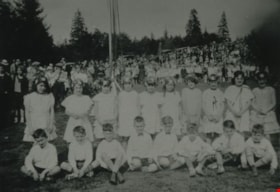
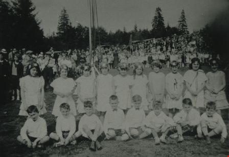
Children at May Day
https://search.heritageburnaby.ca/link/archivedescription35975
- Repository
- City of Burnaby Archives
- Date
- May 1930
- Collection/Fonds
- Burnaby Historical Society fonds
- Description Level
- Item
- Physical Description
- 1 photograph : b&w ; 6.5 x 9.5 cm print
- Scope and Content
- Photograph of two rows of Maypole dancers during Burnaby May Day at Burnaby Park. A large group of spectators is visible in the background.
- Repository
- City of Burnaby Archives
- Date
- May 1930
- Collection/Fonds
- Burnaby Historical Society fonds
- Subseries
- Edmonds School subseries
- Physical Description
- 1 photograph : b&w ; 6.5 x 9.5 cm print
- Description Level
- Item
- Record No.
- 207-024
- Access Restriction
- No restrictions
- Reproduction Restriction
- No known restrictions
- Accession Number
- BHS1988-07
- Scope and Content
- Photograph of two rows of Maypole dancers during Burnaby May Day at Burnaby Park. A large group of spectators is visible in the background.
- Subjects
- Events - May Day
- Clothing
- Media Type
- Photograph
- Notes
- Title based on contents of photograph
- Geographic Access
- Robert Burnaby Park
- Wedgewood Street
- Street Address
- 8155 Wedgewood Street
- Historic Neighbourhood
- East Burnaby (Historic Neighbourhood)
- Planning Study Area
- Lakeview-Mayfield Area
Images

Coldicutt House
https://search.heritageburnaby.ca/link/archivedescription34549
- Repository
- City of Burnaby Archives
- Date
- 1914
- Collection/Fonds
- Burnaby Historical Society fonds
- Description Level
- Item
- Physical Description
- 1 photograph : b&w ; 16.0 x 21.1 cm mounted on 25.1 x 30.1 cm cardboard
- Scope and Content
- Photograph of the exterior of the Coldicutt House at 7510 6th Street.
- Repository
- City of Burnaby Archives
- Date
- 1914
- Collection/Fonds
- Burnaby Historical Society fonds
- Subseries
- Photographs subseries
- Physical Description
- 1 photograph : b&w ; 16.0 x 21.1 cm mounted on 25.1 x 30.1 cm cardboard
- Description Level
- Item
- Record No.
- 044-009
- Access Restriction
- No restrictions
- Reproduction Restriction
- No known restrictions
- Accession Number
- BHS2007-04
- Scope and Content
- Photograph of the exterior of the Coldicutt House at 7510 6th Street.
- Media Type
- Photograph
- Notes
- Title based on contents of photograph
- Geographic Access
- 6th Street
- Street Address
- 7510 6th Street
- Historic Neighbourhood
- East Burnaby (Historic Neighbourhood)
- Planning Study Area
- Second Street Area
Images

Copies of photographs from Esther (Love) Stanley albums
https://search.heritageburnaby.ca/link/museumdescription10003
- Repository
- Burnaby Village Museum
- Date
- [1915-1950] (date of originals), copied 1989
- Collection/Fonds
- Burnaby Village Museum fonds
- Description Level
- File
- Physical Description
- 36 photographs : b&w negatives ; 35 mm
- Scope and Content
- Photographs copied from various photograph albums including; Albert Paker, George Love, Gordon Love and Esther (Love) Stanley. Content includes: Love family in front of the piano inside parlour; Love family members with musical instruments inside parlour; Ben Brandrith and Robert Love in uniforms; …
- Repository
- Burnaby Village Museum
- Collection/Fonds
- Burnaby Village Museum fonds
- Series
- Jesse Love farmhouse series
- Subseries
- Love family photographs subseries
- Description Level
- File
- Physical Description
- 36 photographs : b&w negatives ; 35 mm
- Scope and Content
- Photographs copied from various photograph albums including; Albert Paker, George Love, Gordon Love and Esther (Love) Stanley. Content includes: Love family in front of the piano inside parlour; Love family members with musical instruments inside parlour; Ben Brandrith and Robert Love in uniforms; unidentified Asian man in field with hoe and young trees behind him; wedding cake from Frank Charles Stanley and Esther Love's wedding; land clearing for Love farmhouse; Jesse Love feeding chickens; Jesse and Hannah (Girlie) Love in hats outside on Love farm; large picnic on grass; four generations of Love family members; gatherings of Love family members outside; Love family posed in a car inside a studio (Will, Sarah, George, Phoebe and Martha); Leonard Love dressed as a boy scout; Martha (Dot) with children; Love family members celebrate centennial; Jesse Love and Martha (Dot) Love outside Love farmhouse; Love farmhouse with porch and garden; swing at Love farmhouse; Parker family in living room and view of the Love farmhouse from the front.
- Geographic Access
- Cumberland Street
- Street Address
- 7651 Cumberland Street
- Accession Code
- BV018.41.184
- Access Restriction
- No restrictions
- Reproduction Restriction
- May be restricted by third party rights
- Date
- [1915-1950] (date of originals), copied 1989
- Media Type
- Photograph
- Historic Neighbourhood
- East Burnaby (Historic Neighbourhood)
- Planning Study Area
- Cariboo-Armstrong Area
- Scan Date
- 4-Mar-2019
- Notes
- Title based on contents of photograph
- 36 b&w copy prints accompanying
![Corner view of Love farmhouse, [between 1966 and 1970] thumbnail](/media/hpo/_Data/_BVM_Images/2019/2019_0003_0005_001.jpg?width=280)
Corner view of Love farmhouse
https://search.heritageburnaby.ca/link/museumdescription9919
- Repository
- Burnaby Village Museum
- Date
- [between 1966 and 1970]
- Collection/Fonds
- Love family fonds
- Description Level
- Item
- Physical Description
- 1 photograph : col. ; 10 x 15 cm print
- Scope and Content
- Photograph of the exterior of the Love farmhouse taken at the corner of Fourteenth Avenue and Cumberland Street. The house is hidden behind large trees at it's orignal address of 7651 Cumberland Street (Address pre 1960: 1390 Cumberland Road). This photograph was taken while Elsie Hughes (nee Love)…
- Repository
- Burnaby Village Museum
- Collection/Fonds
- Love family fonds
- Description Level
- Item
- Physical Description
- 1 photograph : col. ; 10 x 15 cm print
- Material Details
- Copy print was made from re-photographing an original colour slide
- Scope and Content
- Photograph of the exterior of the Love farmhouse taken at the corner of Fourteenth Avenue and Cumberland Street. The house is hidden behind large trees at it's orignal address of 7651 Cumberland Street (Address pre 1960: 1390 Cumberland Road). This photograph was taken while Elsie Hughes (nee Love), her husband John Hughes and son Brent Hughes lived in the house. Elsie is the daughter of Sarah (nee Love) and William Parker. Sarah and William purchased the house in 1928, shortly after the death of Sarah's father, Jesse Love. Sarah and William Parker lived in the house with their three children, Albert, Bill and Elsie. William Parker died in 1961 and Sarah continued to live in the house until 1966 before selling it to her daughter Elsie and son in law John Hughes. Elsie and John lived in the house with their son Brent until 1971.
- Subjects
- Buildings - Heritage
- Geographic Access
- 14th Avenue
- Cumberland Street
- Street Address
- 7651 Cumberland Street
- Accession Code
- BV019.3.5
- Access Restriction
- No restrictions
- Reproduction Restriction
- No known restrictions
- Date
- [between 1966 and 1970]
- Media Type
- Photograph
- Historic Neighbourhood
- East Burnaby (Historic Neighbourhood)
- Planning Study Area
- Cariboo-Armstrong Area
- Scan Resolution
- 600
- Scan Date
- 31-Jan-2019
- Scale
- 96
- Photographer
- Parker, Albert "Bert"
- Notes
- Title based on contents of photograph
- See also BV992.15.12
Images
![Corner view of Love farmhouse, [between 1966 and 1970] thumbnail](/media/hpo/_Data/_BVM_Images/2019/2019_0003_0005_001.jpg)
![Corner view of Love farmhouse, [between 1966 and 1970] thumbnail](/media/hpo/_Data/_BVM_Images/2019/2019_0003_0006_001.jpg?width=280)
Corner view of Love farmhouse
https://search.heritageburnaby.ca/link/museumdescription9920
- Repository
- Burnaby Village Museum
- Date
- [between 1966 and 1970]
- Collection/Fonds
- Love family fonds
- Description Level
- Item
- Physical Description
- 1 photograph : col. ; 10 x 15 cm print
- Scope and Content
- Photograph of the exterior of the Love farmhouse taken at the corner of Fourteenth Avenue and Cumberland Street. The north side of the house and kitchen are in view with large trees covering the front of the house at it's orignal address of 7651 Cumberland Street (Address pre 1960: 1390 Cumberland …
- Repository
- Burnaby Village Museum
- Collection/Fonds
- Love family fonds
- Description Level
- Item
- Physical Description
- 1 photograph : col. ; 10 x 15 cm print
- Material Details
- Copy print was made from re-photographing an original colour slide
- Scope and Content
- Photograph of the exterior of the Love farmhouse taken at the corner of Fourteenth Avenue and Cumberland Street. The north side of the house and kitchen are in view with large trees covering the front of the house at it's orignal address of 7651 Cumberland Street (Address pre 1960: 1390 Cumberland Road). This photograph was taken while Elsie Hughes (nee Love), her husband John Hughes and son Brent Hughes lived in the house. Elsie is the daughter of Sarah (nee Love) and William Parker. Sarah and William purchased the house in 1928, shortly after the death of Sarah's father, Jesse Love. Sarah and William Parker lived in the house with their three children, Albert, Bill and Elsie. William Parker died in 1961 and Sarah continued to live in the house until 1966 before selling it to her daughter Elsie and son in law John Hughes. Elsie and John lived in the house with their son Brent until 1971.
- Subjects
- Buildings - Heritage
- Geographic Access
- 14th Avenue
- Cumberland Street
- Street Address
- 7651 Cumberland Street
- Accession Code
- BV019.3.6
- Access Restriction
- No restrictions
- Reproduction Restriction
- No known restrictions
- Date
- [between 1966 and 1970]
- Media Type
- Photograph
- Historic Neighbourhood
- East Burnaby (Historic Neighbourhood)
- Planning Study Area
- Cariboo-Armstrong Area
- Scan Resolution
- 600
- Scan Date
- 31-Jan-2019
- Scale
- 96
- Photographer
- Parker, Albert "Bert"
- Notes
- Title based on contents of photograph
- See also BV992.15.12
Images
![Corner view of Love farmhouse, [between 1966 and 1970] thumbnail](/media/hpo/_Data/_BVM_Images/2019/2019_0003_0006_001.jpg)