Narrow Results By
![805 Grove Avenue, [1925] (date of original), copied 1991 thumbnail](/media/hpo/_Data/_Archives_Images/_Unrestricted/370/370-274.jpg?width=280)
805 Grove Avenue
https://search.heritageburnaby.ca/link/archivedescription37686
- Repository
- City of Burnaby Archives
- Date
- [1925] (date of original), copied 1991
- Collection/Fonds
- Burnaby Historical Society fonds
- Description Level
- Item
- Physical Description
- 1 photograph : b&w ; 2.9 x 5.0 cm print on contact sheet 20.2 x 25.3 cm
- Scope and Content
- Photograph of the exterior of the house at 805 Grove Avenue.
- Repository
- City of Burnaby Archives
- Date
- [1925] (date of original), copied 1991
- Collection/Fonds
- Burnaby Historical Society fonds
- Subseries
- Burnaby Image Bank subseries
- Physical Description
- 1 photograph : b&w ; 2.9 x 5.0 cm print on contact sheet 20.2 x 25.3 cm
- Description Level
- Item
- Record No.
- 370-274
- Access Restriction
- No restrictions
- Reproduction Restriction
- No known restrictions
- Accession Number
- BHS1999-03
- Scope and Content
- Photograph of the exterior of the house at 805 Grove Avenue.
- Subjects
- Buildings - Residential - Houses
- Media Type
- Photograph
- Notes
- Title based on contents of photograph
- 1 b&w copy negative accompanying
- Negative has a pink cast
- Geographic Access
- Grove Avenue
- Street Address
- 805 Grove Avenue
- Historic Neighbourhood
- Lochdale (Historic Neighbourhood)
- Planning Study Area
- Lochdale Area
Images
![805 Grove Avenue, [1925] (date of original), copied 1991 thumbnail](/media/hpo/_Data/_Archives_Images/_Unrestricted/370/370-274.jpg)
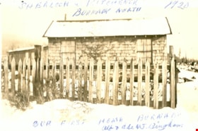
First Burnaby home of Alfred and Ade Bingham
https://search.heritageburnaby.ca/link/museumdescription15
- Repository
- Burnaby Village Museum
- Date
- 1920
- Collection/Fonds
- Burnaby Village Museum Photograph collection
- Description Level
- Item
- Physical Description
- 1 photograph : b&w ; 7.0 x 11.4 cm
- Scope and Content
- Photograph of a snow-covered house with a picket fence around it. This is the first home of Alfred and Ade Bingham, located at Sherlock Avenue and Kitchener Street. An annotation at the top of the photo reads, "Sherlock and Kitchener / Burnaby North / 1920." An annotation at the bottom of the pho…
- Repository
- Burnaby Village Museum
- Collection/Fonds
- Burnaby Village Museum Photograph collection
- Description Level
- Item
- Physical Description
- 1 photograph : b&w ; 7.0 x 11.4 cm
- Scope and Content
- Photograph of a snow-covered house with a picket fence around it. This is the first home of Alfred and Ade Bingham, located at Sherlock Avenue and Kitchener Street. An annotation at the top of the photo reads, "Sherlock and Kitchener / Burnaby North / 1920." An annotation at the bottom of the photograph reads, "Our First Home Burnaby / Alf and Ade MJ. Bingham."
- Names
- Bingham, Alfred "Alf"
- Geographic Access
- Sherlock Avenue
- Kitchener Street
- Accession Code
- HV971.12.83
- Access Restriction
- No restrictions
- Reproduction Restriction
- No known restrictions
- Date
- 1920
- Media Type
- Photograph
- Historic Neighbourhood
- Lochdale (Historic Neighbourhood)
- Planning Study Area
- Lochdale Area
- Scan Resolution
- 600
- Scan Date
- 2023-03-21
- Notes
- Title based on contents of photograph
Images

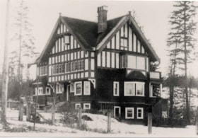
Gavin house
https://search.heritageburnaby.ca/link/archivedescription36002
- Repository
- City of Burnaby Archives
- Date
- 1912
- Collection/Fonds
- Burnaby Historical Society fonds
- Description Level
- Item
- Physical Description
- 1 photograph : b&w ; 8.5 x 12.5 cm print
- Scope and Content
- Photograph of the Gavin house located on Buckingham Road at Sperling. The house was designed by architect A.C. Hope and built for Francis John Gavin and his family.
- Repository
- City of Burnaby Archives
- Date
- 1912
- Collection/Fonds
- Burnaby Historical Society fonds
- Subseries
- Gavin family subseries
- Physical Description
- 1 photograph : b&w ; 8.5 x 12.5 cm print
- Description Level
- Item
- Record No.
- 209-001
- Access Restriction
- No restrictions
- Reproduction Restriction
- No known restrictions
- Accession Number
- BHS1988-09
- Scope and Content
- Photograph of the Gavin house located on Buckingham Road at Sperling. The house was designed by architect A.C. Hope and built for Francis John Gavin and his family.
- Subjects
- Buildings - Residential - Houses
- Media Type
- Photograph
- Notes
- Title based on contents of photograph
- Geographic Access
- Buckingham Avenue
- Sperling Avenue
- Historic Neighbourhood
- Lochdale (Historic Neighbourhood)
- Planning Study Area
- Sperling-Broadway Area
Images

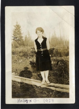
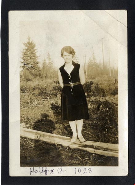
Halifax Str 1928
https://search.heritageburnaby.ca/link/archivedescription97956
- Repository
- City of Burnaby Archives
- Date
- 1928
- Collection/Fonds
- Burnaby Historical Society fonds
- Description Level
- Item
- Physical Description
- 1 photograph : b&w ; 9 cm x 7 cm mounted on black paper 10 cm x 7 cm
- Scope and Content
- Photograph of Dorothy Easthope in the garden at 6671 Halifax Street. She is standing on a wooden plank in the garden, wearing a black belted dress and posed with her hands behind her back.
- Repository
- City of Burnaby Archives
- Date
- 1928
- Collection/Fonds
- Burnaby Historical Society fonds
- Subseries
- Easthope family subseries
- Physical Description
- 1 photograph : b&w ; 9 cm x 7 cm mounted on black paper 10 cm x 7 cm
- Description Level
- Item
- Record No.
- 451-023
- Access Restriction
- No restrictions
- Reproduction Restriction
- No known restrictions
- Accession Number
- BHS2003-06
- Scope and Content
- Photograph of Dorothy Easthope in the garden at 6671 Halifax Street. She is standing on a wooden plank in the garden, wearing a black belted dress and posed with her hands behind her back.
- Media Type
- Photograph
- Notes
- Transcribed title
- Title transcribed from note on verso of photograph
- Geographic Access
- Halifax Street
- Street Address
- 6671 Halifax Street
- Historic Neighbourhood
- Lochdale (Historic Neighbourhood)
- Planning Study Area
- Lochdale Area
Images
![In front of Duthie School, [between 1911 and 1919] thumbnail](/media/hpo/_Data/_Archives_Images/_Unrestricted/316/325-031.jpg?width=280)
In front of Duthie School
https://search.heritageburnaby.ca/link/archivedescription37159
- Repository
- City of Burnaby Archives
- Date
- [between 1911 and 1919]
- Collection/Fonds
- Burnaby Historical Society fonds
- Description Level
- Item
- Physical Description
- 1 photograph : b&w ; 12.5 x 8 cm print
- Scope and Content
- Photograph of a man with surveyor equipment sitting on the wooden sidewalk in front of Duthie School (also called Johnston Road School). This school existed from 1909 to 1921.
- Repository
- City of Burnaby Archives
- Date
- [between 1911 and 1919]
- Collection/Fonds
- Burnaby Historical Society fonds
- Subseries
- Disney family subseries
- Physical Description
- 1 photograph : b&w ; 12.5 x 8 cm print
- Description Level
- Item
- Record No.
- 325-031
- Access Restriction
- No restrictions
- Reproduction Restriction
- No known restrictions
- Accession Number
- BHS1996-04
- Scope and Content
- Photograph of a man with surveyor equipment sitting on the wooden sidewalk in front of Duthie School (also called Johnston Road School). This school existed from 1909 to 1921.
- Subjects
- Buildings - Schools
- Names
- Duthie School
- Media Type
- Photograph
- Photographer
- Disney, John Harold "Jack"
- Notes
- Title based on contents of photograph
- Geographic Access
- Broadway
- Sperling Avenue
- Historic Neighbourhood
- Lochdale (Historic Neighbourhood)
- Planning Study Area
- Sperling-Broadway Area
Images
![In front of Duthie School, [between 1911 and 1919] thumbnail](/media/hpo/_Data/_Archives_Images/_Unrestricted/316/325-031.jpg)
![Johnston Road School, [between 1911 and 1919] thumbnail](/media/hpo/_Data/_Archives_Images/_Unrestricted/316/325-030.jpg?width=280)
Johnston Road School
https://search.heritageburnaby.ca/link/archivedescription37158
- Repository
- City of Burnaby Archives
- Date
- [between 1911 and 1919]
- Collection/Fonds
- Burnaby Historical Society fonds
- Description Level
- Item
- Physical Description
- 1 photograph : b&w ; 7.5 x 12.5 cm print
- Scope and Content
- Photograph of Johnston Road School (also called Duthie School) taken from Broadway. This school existed from 1909 to 1921.
- Repository
- City of Burnaby Archives
- Date
- [between 1911 and 1919]
- Collection/Fonds
- Burnaby Historical Society fonds
- Subseries
- Disney family subseries
- Physical Description
- 1 photograph : b&w ; 7.5 x 12.5 cm print
- Description Level
- Item
- Record No.
- 325-030
- Access Restriction
- No restrictions
- Reproduction Restriction
- No known restrictions
- Accession Number
- BHS1996-04
- Scope and Content
- Photograph of Johnston Road School (also called Duthie School) taken from Broadway. This school existed from 1909 to 1921.
- Subjects
- Buildings - Schools
- Media Type
- Photograph
- Photographer
- Disney, John Harold "Jack"
- Notes
- Title based on contents of photograph
- Geographic Access
- Broadway
- Sperling Avenue
- Historic Neighbourhood
- Lochdale (Historic Neighbourhood)
- Planning Study Area
- Sperling-Broadway Area
Images
![Johnston Road School, [between 1911 and 1919] thumbnail](/media/hpo/_Data/_Archives_Images/_Unrestricted/316/325-030.jpg)

On Curtis Road, North Burnaby
https://search.heritageburnaby.ca/link/archivedescription38854
- Repository
- City of Burnaby Archives
- Date
- 1911
- Collection/Fonds
- Peers Family and Hill Family fonds
- Description Level
- Item
- Physical Description
- 1 photograph : b&w ; 6 x 10 cm on page 14 x 17.5 cm (pasted in album)
- Scope and Content
- Photograph of Claude Hill (right) and E.B. Wentenhall (left) standing on a bridge on Curtis Road in North Burnaby. Both men are holding walking sticks.
- Repository
- City of Burnaby Archives
- Date
- 1911
- Collection/Fonds
- Peers Family and Hill Family fonds
- Physical Description
- 1 photograph : b&w ; 6 x 10 cm on page 14 x 17.5 cm (pasted in album)
- Description Level
- Item
- Record No.
- 477-173
- Access Restriction
- No restrictions
- Reproduction Restriction
- No known restrictions
- Accession Number
- 2007-12
- Scope and Content
- Photograph of Claude Hill (right) and E.B. Wentenhall (left) standing on a bridge on Curtis Road in North Burnaby. Both men are holding walking sticks.
- Subjects
- Structures - Bridges
- Media Type
- Photograph
- Notes
- Title based on caption accompanying photograph
- Geographic Access
- Curtis Street
- Historic Neighbourhood
- Lochdale (Historic Neighbourhood)
- Planning Study Area
- Lochdale Area
Images


Sperling Avenue and Barnet Road
https://search.heritageburnaby.ca/link/archivedescription35442
- Repository
- City of Burnaby Archives
- Date
- 1915 (date of original), copied 1986
- Collection/Fonds
- Burnaby Historical Society fonds
- Description Level
- Item
- Physical Description
- 1 photograph : b&w ; 12.7 x 17.8 cm print
- Scope and Content
- Photograph of a Cadillac full of passengers driving along the plank roadway at Sperling Avenue and Barnet Road.
- Repository
- City of Burnaby Archives
- Date
- 1915 (date of original), copied 1986
- Collection/Fonds
- Burnaby Historical Society fonds
- Subseries
- Pioneer Tales subseries
- Physical Description
- 1 photograph : b&w ; 12.7 x 17.8 cm print
- Description Level
- Item
- Record No.
- 204-300
- Access Restriction
- No restrictions
- Reproduction Restriction
- No restrictions
- Accession Number
- BHS1988-03
- Scope and Content
- Photograph of a Cadillac full of passengers driving along the plank roadway at Sperling Avenue and Barnet Road.
- Media Type
- Photograph
- Photographer
- Eaton, Dr. Carl
- Notes
- Title based on contents of photograph
- Photograph is believed to be taken by Dr. Carl Eaton
- Geographic Access
- Sperling Avenue
- Barnet Road
- Historic Neighbourhood
- Lochdale (Historic Neighbourhood)
- Planning Study Area
- Westridge Area
Images


Sperling Avenue School during construction
https://search.heritageburnaby.ca/link/archivedescription36027
- Repository
- City of Burnaby Archives
- Date
- 1913
- Collection/Fonds
- Burnaby Historical Society fonds
- Description Level
- Item
- Physical Description
- 1 photograph : sepia
- Scope and Content
- Photograph of the Sperling Avenue School during construction. This was the first school ever built by Bruce Patterson.
- Repository
- City of Burnaby Archives
- Date
- 1913
- Collection/Fonds
- Burnaby Historical Society fonds
- Subseries
- Patterson family subseries
- Physical Description
- 1 photograph : sepia
- Description Level
- Item
- Record No.
- 213-009
- Access Restriction
- No restrictions
- Reproduction Restriction
- No known restrictions
- Accession Number
- BHS1988-13
- Scope and Content
- Photograph of the Sperling Avenue School during construction. This was the first school ever built by Bruce Patterson.
- Media Type
- Photograph
- Notes
- Title based on contents of photograph
- Hand written note on verso of photograph reads: "1st School Bruce built"
- Geographic Access
- Sperling Avenue
- Street Address
- 2200 Sperling Avenue
- Historic Neighbourhood
- Lochdale (Historic Neighbourhood)
- Planning Study Area
- Sperling-Broadway Area
Images

![Sperling Avenue School students, [1922] (date of original), copied 1991 thumbnail](/media/hpo/_Data/_Archives_Images/_Unrestricted/370/370-282.jpg?width=280)
Sperling Avenue School students
https://search.heritageburnaby.ca/link/archivedescription37694
- Repository
- City of Burnaby Archives
- Date
- [1922] (date of original), copied 1991
- Collection/Fonds
- Burnaby Historical Society fonds
- Description Level
- Item
- Physical Description
- 1 photograph : b&w ; 3.3 x 5.1 cm print on contact sheet 20.2 x 25.3 cm
- Scope and Content
- Photograph of Sperling Avenue School students, Grades 1 to 8.
- Repository
- City of Burnaby Archives
- Date
- [1922] (date of original), copied 1991
- Collection/Fonds
- Burnaby Historical Society fonds
- Subseries
- Burnaby Image Bank subseries
- Physical Description
- 1 photograph : b&w ; 3.3 x 5.1 cm print on contact sheet 20.2 x 25.3 cm
- Description Level
- Item
- Record No.
- 370-282
- Access Restriction
- No restrictions
- Reproduction Restriction
- No known restrictions
- Accession Number
- BHS1999-03
- Scope and Content
- Photograph of Sperling Avenue School students, Grades 1 to 8.
- Names
- Sperling Avenue School
- Media Type
- Photograph
- Notes
- Title based on contents of photograph
- 1 b&w copy negative accompanying
- Street Address
- 2200 Sperling Avenue
- Historic Neighbourhood
- Lochdale (Historic Neighbourhood)
- Planning Study Area
- Sperling-Broadway Area
Images
![Sperling Avenue School students, [1922] (date of original), copied 1991 thumbnail](/media/hpo/_Data/_Archives_Images/_Unrestricted/370/370-282.jpg)

Tired Tim and Weary Willie
https://search.heritageburnaby.ca/link/archivedescription38855
- Repository
- City of Burnaby Archives
- Date
- 1911
- Collection/Fonds
- Peers Family and Hill Family fonds
- Description Level
- Item
- Physical Description
- 1 photograph : sepia ; 6 x 10 cm on page 14 x 17.5 cm (pasted in album)
- Scope and Content
- Photograph of Claude Hill (left) and E.B. Wentenhall (right) standing on fallen trees in the Curtis Road area of North Burnaby.
- Repository
- City of Burnaby Archives
- Date
- 1911
- Collection/Fonds
- Peers Family and Hill Family fonds
- Physical Description
- 1 photograph : sepia ; 6 x 10 cm on page 14 x 17.5 cm (pasted in album)
- Description Level
- Item
- Record No.
- 477-174
- Access Restriction
- No restrictions
- Reproduction Restriction
- No known restrictions
- Accession Number
- 2007-12
- Scope and Content
- Photograph of Claude Hill (left) and E.B. Wentenhall (right) standing on fallen trees in the Curtis Road area of North Burnaby.
- Subjects
- Land Clearing
- Plants - Trees
- Media Type
- Photograph
- Notes
- Title based on caption accompanying photograph
- Geographic Access
- Curtis Street
- Historic Neighbourhood
- Lochdale (Historic Neighbourhood)
- Planning Study Area
- Lochdale Area
Images

![William Kask, Sr., [between 1925 and 1929] (date of original), copied 1991 thumbnail](/media/hpo/_Data/_Archives_Images/_Unrestricted/370/370-006.jpg?width=280)
William Kask, Sr.
https://search.heritageburnaby.ca/link/archivedescription37418
- Repository
- City of Burnaby Archives
- Date
- [between 1925 and 1929] (date of original), copied 1991
- Collection/Fonds
- Burnaby Historical Society fonds
- Description Level
- Item
- Physical Description
- 1 photograph : b&w ; 2.9 x 4.9 cm print on contact sheet 20.2 x 25.4 cm
- Scope and Content
- Photograph of William "Bill" Kask, Sr., standing in front of a tree at Alex Kask's home at Hastings Street and Kensington Avenue. The property later became the site of a Shell filling station.
- Repository
- City of Burnaby Archives
- Date
- [between 1925 and 1929] (date of original), copied 1991
- Collection/Fonds
- Burnaby Historical Society fonds
- Subseries
- Burnaby Image Bank subseries
- Physical Description
- 1 photograph : b&w ; 2.9 x 4.9 cm print on contact sheet 20.2 x 25.4 cm
- Description Level
- Item
- Record No.
- 370-006
- Access Restriction
- No restrictions
- Reproduction Restriction
- No restrictions
- Accession Number
- BHS1999-03
- Scope and Content
- Photograph of William "Bill" Kask, Sr., standing in front of a tree at Alex Kask's home at Hastings Street and Kensington Avenue. The property later became the site of a Shell filling station.
- Subjects
- Occupations - Entrepreneurs
- Media Type
- Photograph
- Notes
- Title based on contents of photograph
- 1 b&w copy negative accompanying
- Geographic Access
- Hastings Street
- Kensington Avenue
- Historic Neighbourhood
- Lochdale (Historic Neighbourhood)
- Planning Study Area
- Westridge Area
Images
![William Kask, Sr., [between 1925 and 1929] (date of original), copied 1991 thumbnail](/media/hpo/_Data/_Archives_Images/_Unrestricted/370/370-006.jpg)