More like 'basket'
Legends of Vancouver
https://search.heritageburnaby.ca/link/museumlibrary5197
- Repository
- Burnaby Village Museum
- Collection
- Special Collection
- Material Type
- Book
- Accession Code
- BV002.90.3
- Call Number
- 398.2 JOH
- Edition
- 8th ed.
- Place of Publication
- Vancouver
- Publisher
- Saturday Sunset Presses
- Publication Date
- 1913
- Physical Description
- xvii, 138 p. : ill. ; 23 cm.
- Library Subject (LOC)
- Legends--British Columbia--Vancouver Island
- Spirituality--Indigenous--North America
- Geographic Access
- Vancouver
- Notes
- Leather jacket with painted profile, title, and author, includes leather bookmark and souvenir dagger.
- Inside the jacket is a newspaper clipping of a soldier from Vancouver wounded at Vimy Ridge.
- Author's given name and dates : Johnson, E. Pauline (Emily Pauline), (Tekahionwake),1861-1913

Commercial Map of Greater Vancouver and District
https://search.heritageburnaby.ca/link/museumdescription9552
- Repository
- Burnaby Village Museum
- Date
- July 1921
- Collection/Fonds
- Burnaby Village Museum Map collection
- Description Level
- Item
- Physical Description
- 1 map : col. lithograph mounted on linen ; 107 x 138 cm
- Scope and Content
- Commercial map of Greater Vancouver and District. Map depicts district lots, railroads, electric railways, streets, street car stops, schools, buildings, postal block numbers, parks and First Nations reserves. Map covers the geographcial areas of Vancouver, Burnaby, New Westminster, portions of Ric…
- Repository
- Burnaby Village Museum
- Collection/Fonds
- Burnaby Village Museum Map collection
- Description Level
- Item
- Physical Description
- 1 map : col. lithograph mounted on linen ; 107 x 138 cm
- Material Details
- Includes Legend and Index
- Scope and Content
- Commercial map of Greater Vancouver and District. Map depicts district lots, railroads, electric railways, streets, street car stops, schools, buildings, postal block numbers, parks and First Nations reserves. Map covers the geographcial areas of Vancouver, Burnaby, New Westminster, portions of Richmond, West Vancouver, North Vancouver, and Surrey with half mile circles that radiate from Vancouver City Hall on the corner of Main and Hastings. Bottom of map includes an index of street names, along with their corresponding map grid locations. The map is bordered by Marine Drive to the west, North Road to the east, Dempsey Street to the north and 20th Road to the south.
- History
- Bought by donor at thrift store years ago. No known provenance.
- Publisher
- Produced by Photo - Lithography, Colonist , Victoria, B.C.
- Geographic Access
- Vancouver
- Accession Code
- BV018.24.1
- Access Restriction
- No restrictions
- Reproduction Restriction
- No known restrictions
- Date
- July 1921
- Media Type
- Cartographic Material
- Scan Resolution
- 300
- Scan Date
- 16-Jun-20
- Scale
- 100
- Notes
- Transcribed title
- Title on map reads: "COMMERCIAL MAP / OF / GREATER VANCOUVER / AND / DISTRICT / Compiled and Published by / The Vancouver Map & Blueprint Co. Ltd. / 441 Seymour St. Vancouver B.C. / July, 1921".
Images

![Beach, [192-] thumbnail](/media/hpo/_Data/_BVM_Images/1976/1976_0036_0022_001.jpg?width=280)
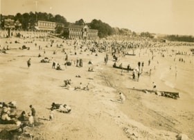
Beach
https://search.heritageburnaby.ca/link/museumdescription660
- Repository
- Burnaby Village Museum
- Date
- [192-]
- Collection/Fonds
- Burnaby Village Museum Photograph collection
- Description Level
- Item
- Physical Description
- 1 photograph : sepia ; 9.8 x 25.4 cm
- Scope and Content
- Photograph of English Bay shoreline, Vancouver populated with people, many of whom are in the water. In view of the photograph, there is a large two-storey building called the Pavillion Bathhouse. Residential housing can be seen along the bank just above the beach as well. There is a paved foot …
- Repository
- Burnaby Village Museum
- Collection/Fonds
- Burnaby Village Museum Photograph collection
- Description Level
- Item
- Physical Description
- 1 photograph : sepia ; 9.8 x 25.4 cm
- Scope and Content
- Photograph of English Bay shoreline, Vancouver populated with people, many of whom are in the water. In view of the photograph, there is a large two-storey building called the Pavillion Bathhouse. Residential housing can be seen along the bank just above the beach as well. There is a paved foot path running along the bank as well. "Marett & Reid Druggists" store can be seen on the left end of the photograph.
- Geographic Access
- Vancouver
- Accession Code
- HV976.36.22
- Access Restriction
- No restrictions
- Reproduction Restriction
- No known restrictions
- Date
- [192-]
- Media Type
- Photograph
- Scan Resolution
- 600
- Scan Date
- 17/8/2006
- Notes
- Title based on contents of photograph
Images
![Beach, [192-] thumbnail](/media/hpo/_Data/_BVM_Images/1976/1976_0036_0022_001.jpg)

English Bay, Vancouver
https://search.heritageburnaby.ca/link/museumdescription1072
- Repository
- Burnaby Village Museum
- Date
- 1911
- Collection/Fonds
- Burnaby Village Museum Photograph collection
- Description Level
- Item
- Physical Description
- 1 photograph : b&w ; 7.3 x 9.9 cm
- Scope and Content
- Photograph of the beach at English Bay, Vancouver. The beach is crowded an buildings can be seen in the background.
- Repository
- Burnaby Village Museum
- Collection/Fonds
- Burnaby Village Museum Photograph collection
- Description Level
- Item
- Physical Description
- 1 photograph : b&w ; 7.3 x 9.9 cm
- Scope and Content
- Photograph of the beach at English Bay, Vancouver. The beach is crowded an buildings can be seen in the background.
- Geographic Access
- Vancouver
- Accession Code
- HV972.50.11
- Access Restriction
- No restrictions
- Reproduction Restriction
- No known restrictions
- Date
- 1911
- Media Type
- Photograph
- Scan Resolution
- 600
- Scan Date
- 2023-04-04
- Photographer
- Dean, H.M.
- Notes
- Title based on contents of photograph
- Annotation on verso of photograph reads: "English Bay/ 1911."
Images

![Hideko Shimotakahara, [1922] (date of original), copied 1986 thumbnail](/media/hpo/_Data/_Archives_Images/_Unrestricted/204/204-013.jpg?width=280)
Hideko Shimotakahara
https://search.heritageburnaby.ca/link/archivedescription35156
- Repository
- City of Burnaby Archives
- Date
- [1922] (date of original), copied 1986
- Collection/Fonds
- Burnaby Historical Society fonds
- Description Level
- Item
- Physical Description
- 1 photograph : b&w ; 12.7 x 17.8 cm print
- Scope and Content
- Photograph of Mrs. Hideko Shimotakahara in front of family home at 4055 Keefer Street (later changed to 4055 Frances Street), North Burnaby. Note the honeysuckle arbor in front. Cherry trees were planted along the boulevard in front of the house.
- Repository
- City of Burnaby Archives
- Date
- [1922] (date of original), copied 1986
- Collection/Fonds
- Burnaby Historical Society fonds
- Subseries
- Pioneer Tales subseries
- Physical Description
- 1 photograph : b&w ; 12.7 x 17.8 cm print
- Description Level
- Item
- Record No.
- 204-013
- Access Restriction
- No restrictions
- Reproduction Restriction
- No known restrictions
- Accession Number
- BHS1988-03
- Scope and Content
- Photograph of Mrs. Hideko Shimotakahara in front of family home at 4055 Keefer Street (later changed to 4055 Frances Street), North Burnaby. Note the honeysuckle arbor in front. Cherry trees were planted along the boulevard in front of the house.
- Names
- Shimotakahara, Hideko
- Media Type
- Photograph
- Notes
- Title based on contents of photograph
- Geographic Access
- Frances Street
- Street Address
- 4055 Frances Street
- Historic Neighbourhood
- Vancouver Heights (Historic Neighbourhood)
- Planning Study Area
- Willingdon Heights Area
Images
![Hideko Shimotakahara, [1922] (date of original), copied 1986 thumbnail](/media/hpo/_Data/_Archives_Images/_Unrestricted/204/204-013.jpg)
![Old Lumberman's Arch, [between 1908 and 1911] thumbnail](/media/hpo/_Data/_BVM_Images/1972/1972_0050_0018_001.jpg?width=280)
Old Lumberman's Arch
https://search.heritageburnaby.ca/link/museumdescription1079
- Repository
- Burnaby Village Museum
- Date
- [between 1908 and 1911]
- Collection/Fonds
- Burnaby Village Museum Photograph collection
- Description Level
- Item
- Physical Description
- 1 photograph : b&w ; 5.9 x 10.2 cm
- Scope and Content
- Photograph of the old Lumberman's Arch by the beachside in Stanley Park, Vancouver. There are people gathered by the arch and standing and sitting on logs strewn on the beach.
- Repository
- Burnaby Village Museum
- Collection/Fonds
- Burnaby Village Museum Photograph collection
- Description Level
- Item
- Physical Description
- 1 photograph : b&w ; 5.9 x 10.2 cm
- Scope and Content
- Photograph of the old Lumberman's Arch by the beachside in Stanley Park, Vancouver. There are people gathered by the arch and standing and sitting on logs strewn on the beach.
- Geographic Access
- Vancouver
- Accession Code
- HV972.50.18
- Access Restriction
- No restrictions
- Reproduction Restriction
- No known restrictions
- Date
- [between 1908 and 1911]
- Media Type
- Photograph
- Scan Resolution
- 600
- Scan Date
- 2023-04-04
- Photographer
- Dean, H.M.
- Notes
- Title based on contents of photograph
Images
![Old Lumberman's Arch, [between 1908 and 1911] thumbnail](/media/hpo/_Data/_BVM_Images/1972/1972_0050_0018_001.jpg)