Narrow Results By
Subject
- Accidents - Automobile Accidents 2
- Advertising Medium - Signs and Signboards 1
- Agriculture - Fruit and Berries 1
- Animals - Cats 2
- Animals - Dogs 4
- Animals - Goats 2
- Animals - Poultry 2
- Arts 1
- Buildings - Civic - Community Centres 2
- Buildings - Civic - Museums 9
- Buildings - Commercial - Restaurants 1
- Buildings - Commercial - Service Stations 2
Person / Organization
- Auvache, Lewis 1
- Auvache, Sylvia Murley 1
- Bell, Janet MacMillan 1
- Brantford Elementary School 3
- Burnaby South High School 14
- Chalmers, Thomas "Tom" 2
- Chalmers, Tom 1
- Community Centred College for the Retired 2
- Emmott, Alan H. 2
- Evans, Alf 3
- Frederick, Margaret "Peggy" Urquhart 2
- Kingsway East School 3

A.E. Brown Residence
https://search.heritageburnaby.ca/link/landmark553
- Repository
- Burnaby Heritage Planning
- Description
- Residential building.
- Associated Dates
- 1924
- Street View URL
- Google Maps Street View
- Repository
- Burnaby Heritage Planning
- Geographic Access
- Sperling Avenue
- Associated Dates
- 1924
- Description
- Residential building.
- Heritage Value
- Built after the end of the First World War, this house features an eclectic blend of Arts and Crafts elements. Constructed for A.E. Brown and a full two storeys in height, it has a front jerkin-headed roof with a jerkin-headed side projection, and a corner wraparound verandah with tapered columns. The house has been maintained in near original condition, with original lapped wooden siding, multi-paned windows and square balusters.
- Locality
- Edmonds
- Historic Neighbourhood
- Edmonds (Historic Neighbourhood)
- Planning Study Area
- Kingsway-Beresford Area
- Ownership
- Private
- Street Address
- 6830 Sperling Avenue
- Street View URL
- Google Maps Street View
Images


Burnaby South High School
https://search.heritageburnaby.ca/link/landmark770
- Repository
- Burnaby Heritage Planning
- Associated Dates
- 1922-1988
- Street View URL
- Google Maps Street View
- Repository
- Burnaby Heritage Planning
- Geographic Access
- Southoaks Crescent
- Associated Dates
- 1922-1988
- Heritage Value
- Burnaby South and Burnaby North were Burnaby's first high schools. The first rooms of the school were built in 1922 on the same grounds as the Kingsway East Elementary School. In 1940, a two-storey building was erected and additions were made in 1963, 1967 and 1972. Kingsway East closed in 1925 and its buildings were used by the high school for Industrial Arts and Home Economics. In the early 1990s, a new "urban education centre" (Burnaby South/B.C. School for the Deaf) was opened, replacing the old Burnaby South High School.
- Historic Neighbourhood
- Edmonds (Historic Neighbourhood)
- Planning Study Area
- Kingsway-Beresford Area
- Street Address
- 6650 Southoaks Crescent
- Street View URL
- Google Maps Street View
Images


Jacob & Margaret Wysong House
https://search.heritageburnaby.ca/link/landmark507
- Repository
- Burnaby Heritage Planning
- Description
- The Jacob and Margaret Wysong House is a two and one-half storey, wood-frame Arts and Crafts house with a hipped roof and hipped dormers. Symmetrical in massing, it is distinguished by its masonry verandah columns, foundations and chimneys. It is located on a corner lot on Sperling Avenue at Stanle…
- Associated Dates
- 1912
- Formal Recognition
- Heritage Designation, Community Heritage Register
- Street View URL
- Google Maps Street View
- Repository
- Burnaby Heritage Planning
- Geographic Access
- Sperling Avenue
- Associated Dates
- 1912
- Formal Recognition
- Heritage Designation, Community Heritage Register
- Enactment Type
- By-law No. 11978
- Enactment Date
- 17/10/2005
- Description
- The Jacob and Margaret Wysong House is a two and one-half storey, wood-frame Arts and Crafts house with a hipped roof and hipped dormers. Symmetrical in massing, it is distinguished by its masonry verandah columns, foundations and chimneys. It is located on a corner lot on Sperling Avenue at Stanley Street in the Edmonds neighbourhood of South Burnaby.
- Heritage Value
- The Jacob and Margaret Wysong House is significant for illustrating the early development of the Edmonds neighbourhood, a speculative subdivision that was created and marketed during the pre-First World War real estate boom. The area’s proximity to New Westminster, coupled with extensive views and two newly developed streetcar lines, ensured that Edmonds attracted a wave of suburban development. The scale of this house is atypical of the usual suburban lots, and reflects the prominence of this location and its spectacular views. Set on a large lot, the Jacob and Margaret Wysong House is a grand estate home that is one of the earliest, and most prominent, in South Burnaby. This is also an exceptional example of Arts and Crafts architecture, displaying the use of native materials that was a hallmark of the style. The first owners were Jacob Wysong and his wife Margaret. Jacob Wysong, a local contractor, constructed the house in 1912. The stonework is exceptional, and the use of rough-cut granite and fieldstone, with overall shingle cladding, recalls the rustic vernacular common in Western park lodges, and evokes a country lifestyle in harmony with nature. The hipped roof was designed with a flat top that acted as a lookout tower that provided views of the surrounding landscape.
- Defining Elements
- Key elements that define the heritage character of the Jacob and Margaret Wysong House include its: - prominent corner location in the Edmonds neighbourhood of South Burnaby - residential form, scale and massing as expressed by its two and one-half storey plus raised basement height, symmetrical plan, hipped roof with flat top, hipped dormers, and hipped roof over the full open front verandah with a central front gable - masonry elements such as rough-cut granite and fieldstone foundations, verandah columns, stair cheeks, and external and internal chimneys - wooden-frame construction including original cedar shingling on dormers and facing verandah, shingling on remainder of house under later stucco cladding, and surviving original dimensional trim facing verandah and on dormers - Arts and Crafts features such as the use of natural materials, open soffits and angled roof overhang - windows including: double-hung 18-over-1 wooden sash windows; multi-paned casement windows; French doors to verandah; and front door with glazed sidelights - associated landscape features including surrounding mature trees, hedges and perimeter plantings
- Historic Neighbourhood
- Edmonds (Historic Neighbourhood)
- Planning Study Area
- Kingsway-Beresford Area
- Function
- Primary Historic--Single Dwelling
- Primary Current--Single Dwelling
- Community
- Edmonds
- Cadastral Identifier
- P.I.D. 000-497-801
- Boundaries
- The Jacob and Margaret Wysong House is comprised of a single residential lot located at 6325 Sperling Avenue, Burnaby.
- Area
- 1087.62
- Contributing Resource
- Building
- Ownership
- Private
- Documentation
- City of Burnaby Planning and Building Department, Heritage Site Files
- Street Address
- 6325 Sperling Avenue
- Street View URL
- Google Maps Street View
Images


Kingsway
https://search.heritageburnaby.ca/link/landmark775
- Repository
- Burnaby Heritage Planning
- Associated Dates
- 1913
- Heritage Value
- The years 1911-1912 saw great expansion and settlement in Burnaby and large public works projects were undertaken to service the growing community. One project that was determined to be a necessity was the construction of a proper highway between New Westminster and Vancouver. The Province and the Municipality agreed to share the costs of construction (with Burnaby paying 25% and the Province 75%) and so Kingsway was built to improve the current Vancouver Road. The road was named after the famous King's Way in London, England.
- Historic Neighbourhood
- Central Park (Historic Neighbourhood)
- Edmonds (Historic Neighbourhood)
- Planning Study Area
- Maywood Area
- Marlborough Area
- Windsor Area
- Kingsway-Beresford Area
- Stride Avenue Area
- Edmonds Area
Images


Kingsway-Beresford Neighbourhood
https://search.heritageburnaby.ca/link/landmark805
- Repository
- Burnaby Heritage Planning
- Associated Dates
- 1955-2008
- Heritage Value
- Since the building boom of the 1950s, the Kingsway-Beresford Neighbourhood has maintained a residential character with the exception of the Kingsway corridor, which has become a primary commercial and light industrial sector.
- Historic Neighbourhood
- Edmonds (Historic Neighbourhood)
- Planning Study Area
- Kingsway-Beresford Area
Images


Kingsway East School
https://search.heritageburnaby.ca/link/landmark546
- Repository
- Burnaby Heritage Planning
- Description
- The Kingsway East School is a two-storey wood-frame Arts and Crafts styled building. The school, and the adjacent cenotaph and memorial tennis courts, comprise Burnaby South Memorial Park.
- Associated Dates
- 1913
- Formal Recognition
- Heritage Designation, Community Heritage Register
- Other Names
- Alan Emmott Centre
- Street View URL
- Google Maps Street View
- Repository
- Burnaby Heritage Planning
- Other Names
- Alan Emmott Centre
- Geographic Access
- Southoaks Crescent
- Associated Dates
- 1913
- Formal Recognition
- Heritage Designation, Community Heritage Register
- Enactment Type
- Bylaw No. 9807
- Enactment Date
- 23/11/1992
- Description
- The Kingsway East School is a two-storey wood-frame Arts and Crafts styled building. The school, and the adjacent cenotaph and memorial tennis courts, comprise Burnaby South Memorial Park.
- Heritage Value
- This school structure completed in 1913, the oldest surviving public education building in the city, was intended to be the auditorium and gymnasium for Burnaby’s first high school. However, because of the 1913 recession and the outbreak of the First World War, it was utilized as the Kingsway East Elementary School for the Edmonds District until 1921. Burnaby South High School opened here in 1922, and after it relocated this building was used for a variety of school purposes until it became redundant. The school was rehabilitated for community purposes in 2002-03 and renamed the Alan Emmott Centre to honor a former Mayor of Burnaby. The impressive scale of the Kingsway East School is indicative of the relative size of the community and its growing demand for schooling at the time of construction, illustrating the value that early community residents placed on education. Built to plans of the Burnaby School Board architect, Joseph Henry Bowman (1864-1943), it also indicates the individual values and design control exercised by the school board during this era. It is also significant for its Arts and Crafts style, allied to the typical Craftsman residential vocabulary, which was employed locally for school buildings of the Edwardian era. By using a common architectural vocabulary, this allowed the institution to reflect the values and aspirations of the local community. The Arts and Crafts style also demonstrated an allegiance to British educational antecedents and a demonstration of loyalty to the Mother Country.
- Historic Neighbourhood
- Edmonds (Historic Neighbourhood)
- Planning Study Area
- Kingsway-Beresford Area
- Function
- Primary Historic--Primary School
- Community
- Burnaby
- Cadastral Identifier
- P.I.D. No. 016-367-154 Legal Description: Lot 1, District Lot 96, Group 1 New Westminster District, Plan 86581
- Boundaries
- The Kingsway East School is comprised of a single municipally-owned property located at 6650 Southoaks Crescent, Burnaby.
- Area
- 6,070.00
- Contributing Resource
- Building
- Landscape Feature
- Structure
- Ownership
- Public (local)
- Documentation
- Heritage Site Files: PC77000 20. City of Burnaby Planning and Building Department, 4949 Canada Way, Burnaby, B.C., V5G 1M2
- Street Address
- 6650 Southoaks Crescent
- Street View URL
- Google Maps Street View
Images


'The Gables'
https://search.heritageburnaby.ca/link/landmark516
- Repository
- Burnaby Heritage Planning
- Description
- 'The Gables' is a one and one-half storey plus basement residence with a distinctive cross-gambrel roof. The foundations and first storey facade are constructed of granite rubble-stone with raised pointing, and the remainder of the house is clad in cedar shingles. It is now part of the Tudor Grove …
- Associated Dates
- 1920
- Formal Recognition
- Heritage Designation, Community Heritage Register
- Other Names
- John & Christina Mackie House
- Street View URL
- Google Maps Street View
- Repository
- Burnaby Heritage Planning
- Other Names
- John & Christina Mackie House
- Geographic Access
- Arbroath Street
- Southoaks Crescent
- Associated Dates
- 1920
- Formal Recognition
- Heritage Designation, Community Heritage Register
- Enactment Type
- Bylaw No. 10314
- Enactment Date
- 15/01/1996
- Description
- 'The Gables' is a one and one-half storey plus basement residence with a distinctive cross-gambrel roof. The foundations and first storey facade are constructed of granite rubble-stone with raised pointing, and the remainder of the house is clad in cedar shingles. It is now part of the Tudor Grove residential complex.
- Heritage Value
- The residence is valued as the house of John Mackie (1879-1937) and Christina Mackie (1881-1959) and is significant as the last house remaining from the original Highland Park subdivision. The area was first laid out in 1902, and then remarketed by C.L. Merritt and Company in 1911 as 'Gilley Park - the Suburb Beautiful.' Located on the B.C. Electric Railway interurban line, this was one of many middle-class commuter suburbs in Burnaby promoted during the Edwardian era. These suburbs were reflective of the City Beautiful Movement, a process of urbanization that sought to create morally, socially and aesthetically uplifting civic environments. The site is significant as a rare example of a modest residence incorporating high quality Arts and Crafts stylistic elements. Unusual for a house of this moderate scale, the foundation, first storey walls and chimney are constructed of rough-dressed granite. John Mackie was a stone mason, and it is assumed that he undertook the work himself. The cross gambrel roof is an unusual feature, relatively uncommon in B.C., from which the house derives its name, ‘The Gables.’
- Defining Elements
- Key elements that define the heritage character of 'The Gables' include its: - location in the original Highland Park subdivision - vernacular residential form, scale and massing as exemplified by the one and one-half storey plus basement height, inset porch and symmetrical, rectangular plan - cross-gambrel roof with closed eaves and returned lower edges, clad with cedar shingles - Arts and Crafts influence as exemplified in its use of natural materials such as rough-dressed granite rubble-stone foundation, first storey walls and chimney, and cedar shingle siding on the upper storey - other elements of masonry construction, such as the granite window-box brackets, granite stair cheeks and granite interior chimney with rustic cap - wooden-sash windows - house name, ‘The Gables,’ carved into a granite block on the left-hand pier of the front porch
- Historic Neighbourhood
- Edmonds (Historic Neighbourhood)
- Planning Study Area
- Kingsway-Beresford Area
- Function
- Primary Historic--Single Dwelling
- Primary Current--Single Dwelling
- Community
- Burnaby
- Cadastral Identifier
- 002-837-765
- Boundaries
- 'The Gables' is comprised of a single residential lot located at 6445 Arbroath Street, Burnaby.
- Area
- 5453.12
- Contributing Resource
- Building
- Ownership
- Private
- Street Address
- 6445 Arbroath Street
- Street View URL
- Google Maps Street View
Images

![Alan Emmott in community centre, [2003] thumbnail](/media/hpo/_Data/_Archives_Images/_Unrestricted/535/535-1804.jpg?width=280)
Alan Emmott in community centre
https://search.heritageburnaby.ca/link/archivedescription96055
- Repository
- City of Burnaby Archives
- Date
- [2003]
- Collection/Fonds
- Burnaby NewsLeader photograph collection
- Description Level
- Item
- Physical Description
- 1 photograph (tiff) : col.
- Scope and Content
- Photograph of Alan Emmott holding a keyboard in a classroom at the Alan Emmott Community Centre.
- Repository
- City of Burnaby Archives
- Date
- [2003]
- Collection/Fonds
- Burnaby NewsLeader photograph collection
- Physical Description
- 1 photograph (tiff) : col.
- Description Level
- Item
- Record No.
- 535-1804
- Access Restriction
- No restrictions
- Reproduction Restriction
- No restrictions
- Accession Number
- 2018-12
- Scope and Content
- Photograph of Alan Emmott holding a keyboard in a classroom at the Alan Emmott Community Centre.
- Media Type
- Photograph
- Photographer
- Bartel, Mario
- Notes
- Title based on caption
- Collected by editorial for use in a January 2003 issue of the Burnaby NewsLeader
- Caption from metadata: "Alan Emmett is amongst the first students getting ready for classes at the Community Centre that bears his name, and is now the new home for the Community College of the Retired. He's taking a computer course."
- Geographic Access
- Southoaks Crescent
- Street Address
- 6650 Southoaks Crescent
- Historic Neighbourhood
- Edmonds (Historic Neighbourhood)
- Planning Study Area
- Kingsway-Beresford Area
Images
![Alan Emmott in community centre, [2003] thumbnail](/media/hpo/_Data/_Archives_Images/_Unrestricted/535/535-1804.jpg)
![Alan Emmott outside the Alan Emmott Centre, [2002] thumbnail](/media/hpo/_Data/_Archives_Images/_Unrestricted/535/535-2835.jpg?width=280)
Alan Emmott outside the Alan Emmott Centre
https://search.heritageburnaby.ca/link/archivedescription97496
- Repository
- City of Burnaby Archives
- Date
- [2002]
- Collection/Fonds
- Burnaby NewsLeader photograph collection
- Description Level
- Item
- Physical Description
- 1 photograph (tiff) : col.
- Scope and Content
- Photograph of Alan Emmott, former reeve and freeman of the City of Burnaby, posing with his arms outstretched outside of the new Alan Emmott Centre community hall, located in the restored former Burnaby South Secondary building, before its official opening.
- Repository
- City of Burnaby Archives
- Date
- [2002]
- Collection/Fonds
- Burnaby NewsLeader photograph collection
- Physical Description
- 1 photograph (tiff) : col.
- Description Level
- Item
- Record No.
- 535-2835
- Access Restriction
- No restrictions
- Reproduction Restriction
- No restrictions
- Accession Number
- 2018-12
- Scope and Content
- Photograph of Alan Emmott, former reeve and freeman of the City of Burnaby, posing with his arms outstretched outside of the new Alan Emmott Centre community hall, located in the restored former Burnaby South Secondary building, before its official opening.
- Subjects
- Officials - Mayors and Reeves
- Buildings - Recreational - Community Halls
- Buildings - Civic - Community Centres
- Names
- Emmott, Alan H.
- Media Type
- Photograph
- Photographer
- Bartel, Mario
- Notes
- Title based on caption
- Collected by editorial for use in a November 2002 issue of the Burnaby NewsLeader
- Caption from metadata: "Alan Emmott, a former mayor of Burnaby and now a Freeman of the City, welcomes visitors to the new community centre that bears his name. The Alan Emmott Centre, in the old Burnaby South Secondary building, officially opens on Saturday."
- Geographic Access
- Southoaks Crescent
- Street Address
- 6650 Southoaks Crescent
- Historic Neighbourhood
- Edmonds (Historic Neighbourhood)
- Planning Study Area
- Kingsway-Beresford Area
Images
![Alan Emmott outside the Alan Emmott Centre, [2002] thumbnail](/media/hpo/_Data/_Archives_Images/_Unrestricted/535/535-2835.jpg)
![Ambulance workers at a car accident, [2000] thumbnail](/media/hpo/_Data/_Archives_Images/_Unrestricted/535/535-2551.jpg?width=280)
Ambulance workers at a car accident
https://search.heritageburnaby.ca/link/archivedescription97019
- Repository
- City of Burnaby Archives
- Date
- [2000]
- Collection/Fonds
- Burnaby NewsLeader photograph collection
- Description Level
- Item
- Physical Description
- 1 photograph (tiff) : col.
- Scope and Content
- Photograph of two unidentified ambulance workers tending to the unidentified occupants of a car involved in a three-vehicle accident on Kingsway by Sperling.
- Repository
- City of Burnaby Archives
- Date
- [2000]
- Collection/Fonds
- Burnaby NewsLeader photograph collection
- Physical Description
- 1 photograph (tiff) : col.
- Description Level
- Item
- Record No.
- 535-2551
- Access Restriction
- No restrictions
- Reproduction Restriction
- No restrictions
- Accession Number
- 2018-12
- Scope and Content
- Photograph of two unidentified ambulance workers tending to the unidentified occupants of a car involved in a three-vehicle accident on Kingsway by Sperling.
- Media Type
- Photograph
- Photographer
- Bartel, Mario
- Notes
- Title based on caption
- Collected by editorial for use in a July 2000 issue of the Burnaby NewsLeader
- Caption from metadata: "Emergency workers tend to two injured occupants in a small pick-up truck, the middle vehicle in a three-vehicle accident during Wednesday's rush hour, on Kingsway, just west of Sperling."
- Geographic Access
- Kingsway
- Sperling Avenue
- Historic Neighbourhood
- Edmonds (Historic Neighbourhood)
- Planning Study Area
- Kingsway-Beresford Area
Images
![Ambulance workers at a car accident, [2000] thumbnail](/media/hpo/_Data/_Archives_Images/_Unrestricted/535/535-2551.jpg)
![Back of Kingsway East School, [between 1914 and 1919] thumbnail](/media/hpo/_Data/_Archives_Images/_Unrestricted/316/325-029.jpg?width=280)
Back of Kingsway East School
https://search.heritageburnaby.ca/link/archivedescription37157
- Repository
- City of Burnaby Archives
- Date
- [between 1914 and 1919]
- Collection/Fonds
- Burnaby Historical Society fonds
- Description Level
- Item
- Physical Description
- 1 photograph : b&w ; 8 x 12.5 cm print
- Scope and Content
- Photograph of the back of Kingsway East School and surrounding fields.
- Repository
- City of Burnaby Archives
- Date
- [between 1914 and 1919]
- Collection/Fonds
- Burnaby Historical Society fonds
- Subseries
- Disney family subseries
- Physical Description
- 1 photograph : b&w ; 8 x 12.5 cm print
- Description Level
- Item
- Record No.
- 325-029
- Access Restriction
- No restrictions
- Reproduction Restriction
- No known restrictions
- Accession Number
- BHS1996-04
- Scope and Content
- Photograph of the back of Kingsway East School and surrounding fields.
- Subjects
- Buildings - Schools
- Names
- Kingsway East School
- Media Type
- Photograph
- Photographer
- Disney, John Harold "Jack"
- Notes
- Title based on contents of photograph
- Geographic Access
- Kingsway
- Mission Avenue
- Street Address
- 6650 Southoaks Crescent
- Historic Neighbourhood
- Edmonds (Historic Neighbourhood)
- Planning Study Area
- Kingsway-Beresford Area
Images
![Back of Kingsway East School, [between 1914 and 1919] thumbnail](/media/hpo/_Data/_Archives_Images/_Unrestricted/316/325-029.jpg)

Brantford Elementary School
https://search.heritageburnaby.ca/link/archivedescription62699
- Repository
- City of Burnaby Archives
- Date
- September 8, 2009
- Collection/Fonds
- Community Heritage Commission Special Projects fonds
- Description Level
- Item
- Physical Description
- 1 photograph (tiff) : col. ; 600 ppi
- Scope and Content
- Photograph of Brantford Elementary School.
- Repository
- City of Burnaby Archives
- Date
- September 8, 2009
- Collection/Fonds
- Community Heritage Commission Special Projects fonds
- Physical Description
- 1 photograph (tiff) : col. ; 600 ppi
- Description Level
- Item
- Record No.
- 503-032
- Access Restriction
- No restrictions
- Reproduction Restriction
- No restrictions
- Accession Number
- 2009-10
- Scope and Content
- Photograph of Brantford Elementary School.
- Subjects
- Buildings - Schools
- Media Type
- Photograph
- Photographer
- Pasch, Rebecca
- Notes
- Title based on contents of photograph
- Geographic Access
- Brantford Avenue
- Street Address
- 6512 Brantford Avenue
- Historic Neighbourhood
- Edmonds (Historic Neighbourhood)
- Planning Study Area
- Kingsway-Beresford Area
Images

![Brantford Elementary school crosswalk, [2004] thumbnail](/media/hpo/_Data/_Archives_Images/_Unrestricted/535/535-2054.jpg?width=280)
Brantford Elementary school crosswalk
https://search.heritageburnaby.ca/link/archivedescription96384
- Repository
- City of Burnaby Archives
- Date
- [2004]
- Collection/Fonds
- Burnaby NewsLeader photograph collection
- Description Level
- Item
- Physical Description
- 1 photograph (tiff) : col.
- Scope and Content
- Photograph of Ernie Kashima, the principal of Brantford Elementary School, standing at a school crosswalk at Sperling Avenue near the elementary school.
- Repository
- City of Burnaby Archives
- Date
- [2004]
- Collection/Fonds
- Burnaby NewsLeader photograph collection
- Physical Description
- 1 photograph (tiff) : col.
- Description Level
- Item
- Record No.
- 535-2054
- Access Restriction
- No restrictions
- Reproduction Restriction
- No restrictions
- Accession Number
- 2018-12
- Scope and Content
- Photograph of Ernie Kashima, the principal of Brantford Elementary School, standing at a school crosswalk at Sperling Avenue near the elementary school.
- Media Type
- Photograph
- Photographer
- Bartel, Mario
- Notes
- Title based on caption
- Collected by editorial for use in a March 2004 issue of the Burnaby NewsLeader
- Caption from metadata: "Ernie Kashima, the principal of Brantford Elementary School, says he pulled his school's student crossing guards from a crossing on Sperling Ave. because of fears for the guards' safety, as the street doesn't have a school speed zone."
- Geographic Access
- Sperling Avenue
- Brantford Avenue
- Street Address
- 6512 Brantford Avenue
- Historic Neighbourhood
- Edmonds (Historic Neighbourhood)
- Planning Study Area
- Kingsway-Beresford Area
Images
![Brantford Elementary school crosswalk, [2004] thumbnail](/media/hpo/_Data/_Archives_Images/_Unrestricted/535/535-2054.jpg)
![Brantford Elementary School Triceratops, [2006] thumbnail](/media/hpo/_Data/_Archives_Images/_Unrestricted/535/535-1883-2.jpg?width=280)
Brantford Elementary School Triceratops
https://search.heritageburnaby.ca/link/archivedescription96186
- Repository
- City of Burnaby Archives
- Date
- [2006]
- Collection/Fonds
- Burnaby NewsLeader photograph collection
- Description Level
- File
- Physical Description
- 2 photographs (tiff) : col.
- Scope and Content
- File contains photographs of Brantford Elementary School students viewing a life-size animatronic Triceratops that visited the school. The dinosaur is part of the Dinosaurs in Gastown exhibit at Storyeum.
- Repository
- City of Burnaby Archives
- Date
- [2006]
- Collection/Fonds
- Burnaby NewsLeader photograph collection
- Physical Description
- 2 photographs (tiff) : col.
- Description Level
- File
- Record No.
- 535-1883
- Access Restriction
- No restrictions
- Reproduction Restriction
- No restrictions
- Accession Number
- 2018-12
- Scope and Content
- File contains photographs of Brantford Elementary School students viewing a life-size animatronic Triceratops that visited the school. The dinosaur is part of the Dinosaurs in Gastown exhibit at Storyeum.
- Subjects
- Persons - Students
- Exhibitions
- Media Type
- Photograph
- Photographer
- Bartel, Mario
- Notes
- Title based on caption
- Collected by editorial for use in a January 2006 issue of the Burnaby NewsLeader
- Caption from metadata for 535-1883-1: "Students at Brantford Elementary School in Burnaby are enthralled by a prehistoric visitor, a life-size animatronic Triceratops on tour from the Dinosaurs in Gastown exhibit at Storyeum, on Tuesday."
- Caption from metadata for 535-1883-2: "A life-size animatronic model of a Triceratops on tour from the Dinosaurs in Gastown exhibit at Storyeum gets some attention as it visits Brantford Elementary School on Tuesday."
- Geographic Access
- Brantford Avenue
- Street Address
- 6512 Brantford Avenue
- Historic Neighbourhood
- Edmonds (Historic Neighbourhood)
- Planning Study Area
- Kingsway-Beresford Area
Images
![Brantford Elementary School Triceratops, [2006] thumbnail](/media/hpo/_Data/_Archives_Images/_Unrestricted/535/535-1883-2.jpg)
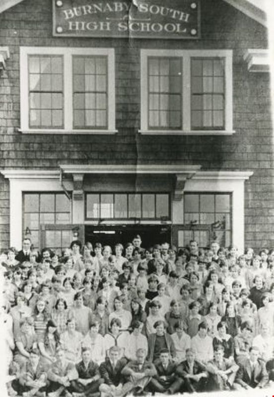
Burnaby South High school
https://search.heritageburnaby.ca/link/archivedescription35169
- Repository
- City of Burnaby Archives
- Date
- 1925 (date of original), copied 1986
- Collection/Fonds
- Burnaby Historical Society fonds
- Description Level
- Item
- Physical Description
- 1 photograph : b&w ; 12.7 x 17.8 cm print
- Scope and Content
- Photograph of the students and staff at Burnaby South High School. Thomas "Tom" Chalmers is 7th from the left in the front row, to the right of the boy wearing a bow tie. Gladys Robins has also been identified as being the girl wearing the striped shirt in the third row from the bottom, third over…
- Repository
- City of Burnaby Archives
- Date
- 1925 (date of original), copied 1986
- Collection/Fonds
- Burnaby Historical Society fonds
- Subseries
- Pioneer Tales subseries
- Physical Description
- 1 photograph : b&w ; 12.7 x 17.8 cm print
- Description Level
- Item
- Record No.
- 204-026
- Access Restriction
- No restrictions
- Reproduction Restriction
- No known restrictions
- Accession Number
- BHS1988-03
- Scope and Content
- Photograph of the students and staff at Burnaby South High School. Thomas "Tom" Chalmers is 7th from the left in the front row, to the right of the boy wearing a bow tie. Gladys Robins has also been identified as being the girl wearing the striped shirt in the third row from the bottom, third over from the left.
- Subjects
- Buildings - Schools
- Media Type
- Photograph
- Notes
- Title based on contents of photograph
- Geographic Access
- Kingsway
- Southoaks Crescent
- Street Address
- 6650 Southoaks Crescent
- Historic Neighbourhood
- Edmonds (Historic Neighbourhood)
- Planning Study Area
- Kingsway-Beresford Area
Images
Burnaby South High School
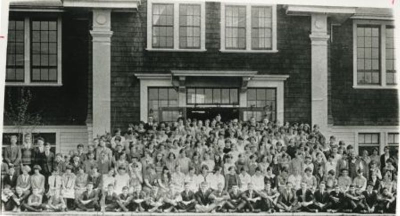
https://search.heritageburnaby.ca/link/archivedescription35171
- Repository
- City of Burnaby Archives
- Date
- 1925 (date of original), copied 1986
- Collection/Fonds
- Burnaby Historical Society fonds
- Description Level
- Item
- Physical Description
- 1 photograph : b&w ; 12.7 x 17.8 cm print
- Scope and Content
- Photograph of students and staff at Burnaby South High School. Thomas "Tom" Chalmers is identified as number eight.
- Repository
- City of Burnaby Archives
- Date
- 1925 (date of original), copied 1986
- Collection/Fonds
- Burnaby Historical Society fonds
- Subseries
- Pioneer Tales subseries
- Physical Description
- 1 photograph : b&w ; 12.7 x 17.8 cm print
- Description Level
- Item
- Record No.
- 204-028
- Access Restriction
- No restrictions
- Reproduction Restriction
- No known restrictions
- Accession Number
- BHS1988-03
- Scope and Content
- Photograph of students and staff at Burnaby South High School. Thomas "Tom" Chalmers is identified as number eight.
- Subjects
- Buildings - Schools
- Media Type
- Photograph
- Notes
- Title based on contents of photograph
- Geographic Access
- Kingsway
- Southoaks Crescent
- Street Address
- 6650 Southoaks Crescent
- Historic Neighbourhood
- Edmonds (Historic Neighbourhood)
- Planning Study Area
- Kingsway-Beresford Area
Images
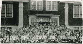
Burnaby South High School
https://search.heritageburnaby.ca/link/archivedescription36498
- Repository
- City of Burnaby Archives
- Date
- [between 1922 and 1930]
- Collection/Fonds
- Burnaby Historical Society fonds
- Description Level
- Item
- Physical Description
- 1 photograph : b&w ; 8.5 x 12.5 cm print
- Scope and Content
- Photograph of Burnaby South High School. This photograph was used as promotional material for Ward and Leverington Contractors.
- Repository
- City of Burnaby Archives
- Date
- [between 1922 and 1930]
- Collection/Fonds
- Burnaby Historical Society fonds
- Subseries
- Ward family subseries
- Physical Description
- 1 photograph : b&w ; 8.5 x 12.5 cm print
- Description Level
- Item
- Record No.
- 280-008
- Access Restriction
- No restrictions
- Reproduction Restriction
- No known restrictions
- Accession Number
- BHS1992-10
- Scope and Content
- Photograph of Burnaby South High School. This photograph was used as promotional material for Ward and Leverington Contractors.
- Media Type
- Photograph
- Geographic Access
- Southoaks Crescent
- Street Address
- 6650 Southoaks Crescent
- Historic Neighbourhood
- Edmonds (Historic Neighbourhood)
- Planning Study Area
- Kingsway-Beresford Area
Images
![Burnaby South High School, [1925] thumbnail](/media/hpo/_Data/_BVM_Images/1972/1972_0200_0001_001.jpg?width=280)
Burnaby South High School
https://search.heritageburnaby.ca/link/museumdescription1106
- Repository
- Burnaby Village Museum
- Date
- [1925]
- Collection/Fonds
- Burnaby Village Museum Photograph collection
- Description Level
- Item
- Physical Description
- 1 photograph : b&w ; 17.7 x 12.7 cm
- Scope and Content
- Photograph of an unidentified class of teenaged girls and a female teacher. They are standing on the stairs or sitting on chairs laid out in front of the stairs to a double door to the school. The teacher is sitting on the right side of the photograph in the front row. All the girls have short hai…
- Repository
- Burnaby Village Museum
- Collection/Fonds
- Burnaby Village Museum Photograph collection
- Description Level
- Item
- Physical Description
- 1 photograph : b&w ; 17.7 x 12.7 cm
- Scope and Content
- Photograph of an unidentified class of teenaged girls and a female teacher. They are standing on the stairs or sitting on chairs laid out in front of the stairs to a double door to the school. The teacher is sitting on the right side of the photograph in the front row. All the girls have short hair, either parted and straight or bobbed. They are wearing loose fitting dresses with stockings. Some have scarves, ties and/or beads. The inscription and the signed gift form from the donor identify the photograph as a class at Burnaby South Highschool, from 1925. Inscribed on the negative and printed on the lower left of the photo: "#6." Annotated on the back of the photo: "1925 / B South." Stamped on the back of the photo: "Lloyd's Studio / 3966 Kingsway / McKay, B.C. Carl. 343R2."
- Subjects
- Occupations - Teachers
- Geographic Access
- Southoaks Crescent
- Street Address
- 6650 Southoaks Crescent
- Accession Code
- HV972.200.1
- Access Restriction
- No restrictions
- Reproduction Restriction
- May be restricted by third party rights
- Date
- [1925]
- Media Type
- Photograph
- Historic Neighbourhood
- Edmonds (Historic Neighbourhood)
- Planning Study Area
- Kingsway-Beresford Area
- Scan Resolution
- 600
- Scan Date
- 2023-04-18
- Photographer
- Lloyd, Frank Ernest
- Notes
- Title based on contents of photograph
Images
![Burnaby South High School, [1925] thumbnail](/media/hpo/_Data/_BVM_Images/1972/1972_0200_0001_001.jpg)
![Burnaby South High School soccer team, [1926] (date of original), copied 1986 thumbnail](/media/hpo/_Data/_Archives_Images/_Unrestricted/204/204-317.jpg?width=280)
Burnaby South High School soccer team
https://search.heritageburnaby.ca/link/archivedescription35459
- Repository
- City of Burnaby Archives
- Date
- [1926] (date of original), copied 1986
- Collection/Fonds
- Burnaby Historical Society fonds
- Description Level
- Item
- Physical Description
- 1 photograph : b&w ; 12.7 x 17.8 cm print
- Scope and Content
- Photograph of the Burnaby South High School soccer team, semi-finalists in the Greater Vancouver championship game, but beaten 3-0 by Vancouver Junior High. Identified: (front row, centre behind ball) Tom Chalmers. Teacher: Mr. H.B. Smith.
- Repository
- City of Burnaby Archives
- Date
- [1926] (date of original), copied 1986
- Collection/Fonds
- Burnaby Historical Society fonds
- Subseries
- Pioneer Tales subseries
- Physical Description
- 1 photograph : b&w ; 12.7 x 17.8 cm print
- Description Level
- Item
- Record No.
- 204-317
- Access Restriction
- No restrictions
- Reproduction Restriction
- No known restrictions
- Accession Number
- BHS1988-03
- Scope and Content
- Photograph of the Burnaby South High School soccer team, semi-finalists in the Greater Vancouver championship game, but beaten 3-0 by Vancouver Junior High. Identified: (front row, centre behind ball) Tom Chalmers. Teacher: Mr. H.B. Smith.
- Media Type
- Photograph
- Notes
- Title based on contents of photograph
- Geographic Access
- Southoaks Crescent
- Street Address
- 6650 Southoaks Crescent
- Historic Neighbourhood
- Edmonds (Historic Neighbourhood)
- Planning Study Area
- Kingsway-Beresford Area
Images
![Burnaby South High School soccer team, [1926] (date of original), copied 1986 thumbnail](/media/hpo/_Data/_Archives_Images/_Unrestricted/204/204-317.jpg)
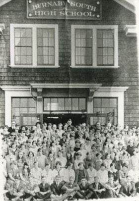
![Burnaby South High School students, [1927 or 1928] thumbnail](/media/hpo/_Data/_Archives_Images/_Unrestricted/126/136-003.jpg?width=280)
Burnaby South High School students
https://search.heritageburnaby.ca/link/archivedescription34807
- Repository
- City of Burnaby Archives
- Date
- [1927 or 1928]
- Collection/Fonds
- Burnaby Historical Society fonds
- Description Level
- Item
- Physical Description
- 1 photograph : b&w ; 19.5 x 50.5 cm
- Scope and Content
- Photograph of Burnaby South High School students seated and standing outside the school building. A sign at the top centre of the building reads, "Burnaby South / High School."
- Repository
- City of Burnaby Archives
- Date
- [1927 or 1928]
- Collection/Fonds
- Burnaby Historical Society fonds
- Subseries
- Ethel Derrick subseries
- Physical Description
- 1 photograph : b&w ; 19.5 x 50.5 cm
- Description Level
- Item
- Record No.
- 136-003
- Access Restriction
- No restrictions
- Reproduction Restriction
- No known restrictions
- Accession Number
- BHS1985-05
- Scope and Content
- Photograph of Burnaby South High School students seated and standing outside the school building. A sign at the top centre of the building reads, "Burnaby South / High School."
- Subjects
- Buildings - Schools
- Media Type
- Photograph
- Notes
- Title based on contents of photograph
- Geographic Access
- Southoaks Crescent
- Street Address
- 6650 Southoaks Crescent
- Historic Neighbourhood
- Edmonds (Historic Neighbourhood)
- Planning Study Area
- Kingsway-Beresford Area
Images
![Burnaby South High School students, [1927 or 1928] thumbnail](/media/hpo/_Data/_Archives_Images/_Unrestricted/126/136-003.jpg)