Narrow Results By
Subject
- Aerial Photographs 2
- Animals - Cats 1
- Animals - Dogs 1
- Buildings - Commercial 5
- Buildings - Residential - Houses 4
- Construction 3
- Construction Tools and Equipment 1
- Documentary Artifacts - Postcards 3
- Energy Production Tools and Equipment 1
- Geographic Features - Creeks 1
- Geographic Features - Inlets 1
- Geographic Features - Roads 1
![Land Clearing, [1913] (date of original), copied 1986 thumbnail](/media/hpo/_Data/_Archives_Images/_Unrestricted/204/204-226.jpg?width=280)
Land Clearing
https://search.heritageburnaby.ca/link/archivedescription35369
- Repository
- City of Burnaby Archives
- Date
- [1913] (date of original), copied 1986
- Collection/Fonds
- Burnaby Historical Society fonds
- Description Level
- Item
- Physical Description
- 1 photograph : b&w ; 12.7 x 17.8 cm print
- Scope and Content
- Photograph of land clearing by a crew contracted by the municipality to clear the area between Colborne Avenue, Brantford Avenue and Imperial Street in South Burnaby. William Walker was a member of this crew. The land was cleared by blasting.
- Repository
- City of Burnaby Archives
- Date
- [1913] (date of original), copied 1986
- Collection/Fonds
- Burnaby Historical Society fonds
- Subseries
- Pioneer Tales subseries
- Physical Description
- 1 photograph : b&w ; 12.7 x 17.8 cm print
- Description Level
- Item
- Record No.
- 204-226
- Access Restriction
- No restrictions
- Reproduction Restriction
- No known restrictions
- Accession Number
- BHS1988-03
- Scope and Content
- Photograph of land clearing by a crew contracted by the municipality to clear the area between Colborne Avenue, Brantford Avenue and Imperial Street in South Burnaby. William Walker was a member of this crew. The land was cleared by blasting.
- Subjects
- Land Clearing
- Media Type
- Photograph
- Notes
- Title based on contents of photograph
- Historic Neighbourhood
- Edmonds (Historic Neighbourhood)
- Planning Study Area
- Kingsway-Beresford Area
Images
![Land Clearing, [1913] (date of original), copied 1986 thumbnail](/media/hpo/_Data/_Archives_Images/_Unrestricted/204/204-226.jpg)
![Land clearing crew, [1912] (date of original), copied 1991 thumbnail](/media/hpo/_Data/_Archives_Images/_Unrestricted/370/370-778.jpg?width=280)
Land clearing crew
https://search.heritageburnaby.ca/link/archivedescription38191
- Repository
- City of Burnaby Archives
- Date
- [1912] (date of original), copied 1991
- Collection/Fonds
- Burnaby Historical Society fonds
- Description Level
- Item
- Physical Description
- 1 photograph : b&w ; 3.2 x 4.8 cm print on contact sheet 20.4 x 26.5 cm
- Scope and Content
- Photograph of a land clearing crew, with horses and tools, in the Metrotown area near McKay Avenue.
- Repository
- City of Burnaby Archives
- Date
- [1912] (date of original), copied 1991
- Collection/Fonds
- Burnaby Historical Society fonds
- Subseries
- Burnaby Image Bank subseries
- Physical Description
- 1 photograph : b&w ; 3.2 x 4.8 cm print on contact sheet 20.4 x 26.5 cm
- Description Level
- Item
- Record No.
- 370-778
- Access Restriction
- No restrictions
- Reproduction Restriction
- No known restrictions
- Accession Number
- BHS1999-03
- Scope and Content
- Photograph of a land clearing crew, with horses and tools, in the Metrotown area near McKay Avenue.
- Media Type
- Photograph
- Notes
- Title based on contents of photograph
- 1 b&w copy negative accompanying
- Negative has a pink cast
- Geographic Access
- McKay Avenue
- Historic Neighbourhood
- Central Park (Historic Neighbourhood)
- Planning Study Area
- Maywood Area
Images
![Land clearing crew, [1912] (date of original), copied 1991 thumbnail](/media/hpo/_Data/_Archives_Images/_Unrestricted/370/370-778.jpg)
Aerial photograph of Burnaby Mountain
https://search.heritageburnaby.ca/link/archivedescription64460
- Repository
- City of Burnaby Archives
- Date
- [1957 or 1958]
- Collection/Fonds
- Burnaby Historical Society fonds
- Description Level
- Item
- Physical Description
- 1 photograph : b&w ; 14 x 14 cm
- Scope and Content
- Aerial photograph of the Burnaby Mountain park and Centennial Pavilion, under construction.
- Repository
- City of Burnaby Archives
- Date
- [1957 or 1958]
- Collection/Fonds
- Burnaby Historical Society fonds
- Subseries
- North Burnaby Board of Trade subseries
- Physical Description
- 1 photograph : b&w ; 14 x 14 cm
- Description Level
- Item
- Record No.
- 476-026
- Access Restriction
- No restrictions
- Reproduction Restriction
- Reproduce for fair dealing purposes only
- Accession Number
- BHS2005-8
- Scope and Content
- Aerial photograph of the Burnaby Mountain park and Centennial Pavilion, under construction.
- Subjects
- Aerial Photographs
- Land Clearing
- Media Type
- Photograph
- Photographer
- Hunting Survey Corporation Limited
- Notes
- Title based on contents of photograph
- Geographic Access
- Burnaby Mountain Conservation Area
- Centennial Way
- Street Address
- 100 Centennial Way
- Planning Study Area
- Burnaby Mountain Area
![Aerial photograph of Burnaby Mountain, [1957 or 1958] thumbnail](/media/hpo/_Data/_Archives_Images/_Unrestricted/371/476-025.jpg?width=280)
Aerial photograph of Burnaby Mountain
https://search.heritageburnaby.ca/link/archivedescription39742
- Repository
- City of Burnaby Archives
- Date
- [1957 or 1958]
- Collection/Fonds
- Burnaby Historical Society fonds
- Description Level
- Item
- Physical Description
- 1 photograph : b&w ; 14 x 14 cm
- Scope and Content
- Aerial photograph of the Burnaby Mountain park and Centennial Pavilion, under construction.
- Repository
- City of Burnaby Archives
- Date
- [1957 or 1958]
- Collection/Fonds
- Burnaby Historical Society fonds
- Subseries
- North Burnaby Board of Trade subseries
- Physical Description
- 1 photograph : b&w ; 14 x 14 cm
- Description Level
- Item
- Record No.
- 476-025
- Access Restriction
- No restrictions
- Reproduction Restriction
- Reproduce for fair dealing purposes only
- Accession Number
- BHS2005-8
- Scope and Content
- Aerial photograph of the Burnaby Mountain park and Centennial Pavilion, under construction.
- Subjects
- Aerial Photographs
- Land Clearing
- Media Type
- Photograph
- Photographer
- Hunting Survey Corporation Limited
- Notes
- Title based on contents of photograph.
- Geographic Access
- Burnaby Mountain Conservation Area
- Centennial Way
- Street Address
- 100 Centennial Way
- Planning Study Area
- Burnaby Mountain Area
Images
![Aerial photograph of Burnaby Mountain, [1957 or 1958] thumbnail](/media/hpo/_Data/_Archives_Images/_Unrestricted/371/476-025.jpg)

Allanson family clearing land
https://search.heritageburnaby.ca/link/archivedescription35793
- Repository
- City of Burnaby Archives
- Date
- 1923 (date of original), copied 1986
- Collection/Fonds
- Burnaby Historical Society fonds
- Description Level
- Item
- Physical Description
- 1 photograph : b&w ; 12.7 x 17.8 cm print
- Scope and Content
- Photograph of the Allanson family clearing the land at 12 Warwick Avenue bought by Malcolm and Mabel Allanson. Left to right: William Allanson, Mabel Allanson, Malcolm Allanson, and Jessie Allanson. William and Jessie Allanson are the parents of Malcolm. Mabel and Malcolm Allanson are married.
- Repository
- City of Burnaby Archives
- Date
- 1923 (date of original), copied 1986
- Collection/Fonds
- Burnaby Historical Society fonds
- Subseries
- Pioneer Tales subseries
- Physical Description
- 1 photograph : b&w ; 12.7 x 17.8 cm print
- Description Level
- Item
- Record No.
- 204-651
- Access Restriction
- No restrictions
- Reproduction Restriction
- No known restrictions
- Accession Number
- BHS1988-03
- Scope and Content
- Photograph of the Allanson family clearing the land at 12 Warwick Avenue bought by Malcolm and Mabel Allanson. Left to right: William Allanson, Mabel Allanson, Malcolm Allanson, and Jessie Allanson. William and Jessie Allanson are the parents of Malcolm. Mabel and Malcolm Allanson are married.
- Subjects
- Land Clearing
- Plants - Trees
- Media Type
- Photograph
- Notes
- Title based on contents of photograph
- Geographic Access
- Warwick Avenue
- Street Address
- 12 Warwick Avenue
- Historic Neighbourhood
- Capitol Hill (Historic Neighbourhood)
- Planning Study Area
- Capitol Hill Area
Images

![Anderson and Phillips Builders, [between 1910 and 1914] thumbnail](/media/hpo/_Data/_Archives_Images/_Unrestricted/487/487-029.jpg?width=280)
Anderson and Phillips Builders
https://search.heritageburnaby.ca/link/archivedescription57728
- Repository
- City of Burnaby Archives
- Date
- [between 1910 and 1914]
- Collection/Fonds
- J.W. Phillips fonds
- Description Level
- Item
- Physical Description
- 1 photograph : b&w glass negative ; 11 x 15.5 cm
- Scope and Content
- Photograph of a newly constructed house with land clearing debris and labourers working in the yard. A sign on the house reads; "Anderson and Phillips Builders", although the location and the specific individuals are unidentified (items no. 487-022 and 487-032 depict this house completed).
- Repository
- City of Burnaby Archives
- Date
- [between 1910 and 1914]
- Collection/Fonds
- J.W. Phillips fonds
- Physical Description
- 1 photograph : b&w glass negative ; 11 x 15.5 cm
- Material Details
- Emulsion measures 11 x 15.5 cm on the glass; entire glass plate measures 12 x 16 cm
- Description Level
- Item
- Record No.
- 487-029
- Access Restriction
- No restrictions
- Reproduction Restriction
- No known restrictions
- Accession Number
- 2008-18
- Scope and Content
- Photograph of a newly constructed house with land clearing debris and labourers working in the yard. A sign on the house reads; "Anderson and Phillips Builders", although the location and the specific individuals are unidentified (items no. 487-022 and 487-032 depict this house completed).
- Media Type
- Photograph
- Photographer
- Phillips, James William "Jim"
- Notes
- Title based on contents of photograph
Images
![Anderson and Phillips Builders, [between 1910 and 1914] thumbnail](/media/hpo/_Data/_Archives_Images/_Unrestricted/487/487-029.jpg)

Annie Eshelby in front of a felled tree
https://search.heritageburnaby.ca/link/archivedescription35363
- Repository
- City of Burnaby Archives
- Date
- 1924
- Collection/Fonds
- Burnaby Historical Society fonds
- Description Level
- Item
- Physical Description
- 1 photograph : b&w ; 12.7 x 17.8 cm print
- Scope and Content
- Photograph of Mrs. Annie Eshelby in front of a felled tree measuring six feet in diameter. She is sitting on a chair with a black and white cat lying across her lap. This photograph was taken at the lot on Fell Avenue and Dundas Street, North Burnaby, which was cleared for the Eshelby family home. …
- Repository
- City of Burnaby Archives
- Date
- 1924
- Collection/Fonds
- Burnaby Historical Society fonds
- Subseries
- Pioneer Tales subseries
- Physical Description
- 1 photograph : b&w ; 12.7 x 17.8 cm print
- Description Level
- Item
- Record No.
- 204-220
- Access Restriction
- No restrictions
- Reproduction Restriction
- No known restrictions
- Accession Number
- BHS1988-03
- Scope and Content
- Photograph of Mrs. Annie Eshelby in front of a felled tree measuring six feet in diameter. She is sitting on a chair with a black and white cat lying across her lap. This photograph was taken at the lot on Fell Avenue and Dundas Street, North Burnaby, which was cleared for the Eshelby family home. Annie Eshelby (nee Perrey) was married to Frank Eshelby. They settled in Burnaby after moving from England in 1922.
- Subjects
- Animals - Cats
- Land Clearing
- Plants - Trees
- Names
- Eshelby, Annie Perrey
- Media Type
- Photograph
- Notes
- Title based on contents of photograph
- Geographic Access
- Fell Avenue
- Dundas Street
- Historic Neighbourhood
- Capitol Hill (Historic Neighbourhood)
- Planning Study Area
- Capitol Hill Area
Images


Armstrong Avenue school site
https://search.heritageburnaby.ca/link/archivedescription34064
- Repository
- City of Burnaby Archives
- Date
- 1911
- Collection/Fonds
- Burnaby Historical Society fonds
- Description Level
- Item
- Physical Description
- 1 photograph : b&w postcard ; 6.2 x 10.4 cm
- Scope and Content
- Photographic postcard of men sawing down a tree at the Armstrong Avenue School site at 8757 Armstrong Avenue. The accompanying description refers to it as the "bee tree."
- Repository
- City of Burnaby Archives
- Date
- 1911
- Collection/Fonds
- Burnaby Historical Society fonds
- Subseries
- Photographs subseries
- Physical Description
- 1 photograph : b&w postcard ; 6.2 x 10.4 cm
- Description Level
- Item
- Record No.
- 007-001
- Access Restriction
- No restrictions
- Reproduction Restriction
- No known restrictions
- Accession Number
- BHS2007-04
- Scope and Content
- Photographic postcard of men sawing down a tree at the Armstrong Avenue School site at 8757 Armstrong Avenue. The accompanying description refers to it as the "bee tree."
- Names
- Armstrong Avenue School
- Media Type
- Photograph
- Notes
- Title based on contents of photograph
- Postcard has been cropped
- Geographic Access
- Armstrong Avenue
- Street Address
- 8757 Armstrong Avenue
- Historic Neighbourhood
- East Burnaby (Historic Neighbourhood)
- Planning Study Area
- Cariboo-Armstrong Area
Images


B.G. Walker house
https://search.heritageburnaby.ca/link/archivedescription35002
- Repository
- City of Burnaby Archives
- Date
- 1910 (date of original), copied 1986
- Collection/Fonds
- Burnaby Historical Society fonds
- Description Level
- Item
- Physical Description
- 1 photograph : b&w postcard ; 8.4 x 13.8 cm
- Scope and Content
- Photographic postcard of the B.G. Walker house, Edmonds Street and Kingsway. Note the cedar stumps in background.
- Repository
- City of Burnaby Archives
- Date
- 1910 (date of original), copied 1986
- Collection/Fonds
- Burnaby Historical Society fonds
- Subseries
- Patterson family subseries
- Physical Description
- 1 photograph : b&w postcard ; 8.4 x 13.8 cm
- Description Level
- Item
- Record No.
- 171-023
- Access Restriction
- Open access
- Reproduction Restriction
- No known restrictions
- Accession Number
- BHS1986-20
- Scope and Content
- Photographic postcard of the B.G. Walker house, Edmonds Street and Kingsway. Note the cedar stumps in background.
- Media Type
- Photograph
- Notes
- Title based on contents of photograph
- Geographic Access
- Edmonds Street
- Kingsway
- Historic Neighbourhood
- Edmonds (Historic Neighbourhood)
Images


Birth of a House
https://search.heritageburnaby.ca/link/archivedescription79788
- Repository
- City of Burnaby Archives
- Date
- May 1950
- Collection/Fonds
- Yanko family fonds
- Description Level
- Item
- Physical Description
- 1 photograph : b&w ; 8 x 5.5 cm
- Scope and Content
- Photograph of the construction site for the Yanko family house at 7385 Broadway (later renumbered 7391) in Burnaby.
- Repository
- City of Burnaby Archives
- Date
- May 1950
- Collection/Fonds
- Yanko family fonds
- Physical Description
- 1 photograph : b&w ; 8 x 5.5 cm
- Material Details
- Secured to album page with photo corners
- Description Level
- Item
- Record No.
- 545-438
- Access Restriction
- No restrictions
- Reproduction Restriction
- No restrictions
- Accession Number
- 2012-09
- Scope and Content
- Photograph of the construction site for the Yanko family house at 7385 Broadway (later renumbered 7391) in Burnaby.
- Subjects
- Construction
- Land Clearing
- Media Type
- Photograph
- Notes
- Transcribed title (from album page)
- Note written on album page reads: "'Birth of a House' / Started May 1950 / Moved in April 6, 1951"
- Note in black ink on verso of photograph reads: "#6 House May 1950"
- Street Address
- 7391 Broadway
- Planning Study Area
- Sperling-Broadway Area
Images

![Blasted stump, [1910 or 1911] thumbnail](/media/hpo/_Data/_Archives_Images/_Unrestricted/487/487-037.jpg?width=280)
Blasted stump
https://search.heritageburnaby.ca/link/archivedescription65899
- Repository
- City of Burnaby Archives
- Date
- [1910 or 1911]
- Collection/Fonds
- J.W. Phillips fonds
- Description Level
- Item
- Physical Description
- 1 photograph : b&w glass negative ; 11 x 15.5 cm
- Scope and Content
- Photograph of an unidentified man (likely either Jack Holmes) helping to clear land near the Phillips home on Ellsemere Avenue. He is standing in front of the stump that he just blasted, resting an axe at his side. The stump is in pieces and still smoldering.
- Repository
- City of Burnaby Archives
- Date
- [1910 or 1911]
- Collection/Fonds
- J.W. Phillips fonds
- Physical Description
- 1 photograph : b&w glass negative ; 11 x 15.5 cm
- Material Details
- Emulsion measures 11 x 15.5 cm on the glass; entire glass plate measures 16 x 12 cm
- Description Level
- Item
- Record No.
- 487-037
- Access Restriction
- No restrictions
- Reproduction Restriction
- No known restrictions
- Accession Number
- 2008-18
- Scope and Content
- Photograph of an unidentified man (likely either Jack Holmes) helping to clear land near the Phillips home on Ellsemere Avenue. He is standing in front of the stump that he just blasted, resting an axe at his side. The stump is in pieces and still smoldering.
- Subjects
- Land Clearing
- Media Type
- Photograph
- Photographer
- Phillips, James William "Jim"
- Notes
- Title based on contents of photograph
- Geographic Access
- Ellesmere Avenue
- Street Address
- 200 Ellesmere Avenue
- Historic Neighbourhood
- Capitol Hill (Historic Neighbourhood)
- Planning Study Area
- Capitol Hill Area
Images
![Blasted stump, [1910 or 1911] thumbnail](/media/hpo/_Data/_Archives_Images/_Unrestricted/487/487-037.jpg)
Bonnett family
https://search.heritageburnaby.ca/link/archivedescription37005
- Repository
- City of Burnaby Archives
- Date
- 1918 (date of original), copied 1992
- Collection/Fonds
- Burnaby Historical Society fonds
- Description Level
- Item
- Physical Description
- 1 photograph : b&w ; 8.7 x 12.7 cm print
- Scope and Content
- Photograph of Mrs. Una Bonnett and three of her childen: (left to right) Victor, Thais and Austa, at their family home at 21 North Hythe Avenue. A large stump is visible in the background.
- Repository
- City of Burnaby Archives
- Date
- 1918 (date of original), copied 1992
- Collection/Fonds
- Burnaby Historical Society fonds
- Subseries
- Burnaby Centennial Anthology subseries
- Physical Description
- 1 photograph : b&w ; 8.7 x 12.7 cm print
- Description Level
- Item
- Record No.
- 315-463
- Access Restriction
- No restrictions
- Reproduction Restriction
- No known restrictions
- Accession Number
- BHS1994-04
- Scope and Content
- Photograph of Mrs. Una Bonnett and three of her childen: (left to right) Victor, Thais and Austa, at their family home at 21 North Hythe Avenue. A large stump is visible in the background.
- Subjects
- Land Clearing
- Media Type
- Photograph
- Notes
- Title based on contents of photograph
- Geographic Access
- Hythe Avenue North
- Street Address
- 21 Hythe Avenue North
- Historic Neighbourhood
- Capitol Hill (Historic Neighbourhood)
- Planning Study Area
- Capitol Hill Area
Images
![Burrard Inlet, [1912] (date of original), copied 1986 thumbnail](/media/hpo/_Data/_Archives_Images/_Unrestricted/204/204-704.jpg?width=280)
Burrard Inlet
https://search.heritageburnaby.ca/link/archivedescription35845
- Repository
- City of Burnaby Archives
- Date
- [1912] (date of original), copied 1986
- Collection/Fonds
- Burnaby Historical Society fonds
- Description Level
- Item
- Physical Description
- 1 photograph : b&w ; 12.7 x 17.8 cm print
- Scope and Content
- Photograph of Burrard Inlet taken looking north from Capitol Hill.
- Repository
- City of Burnaby Archives
- Date
- [1912] (date of original), copied 1986
- Collection/Fonds
- Burnaby Historical Society fonds
- Subseries
- Pioneer Tales subseries
- Physical Description
- 1 photograph : b&w ; 12.7 x 17.8 cm print
- Description Level
- Item
- Record No.
- 204-704
- Access Restriction
- No restrictions
- Reproduction Restriction
- No known restrictions
- Accession Number
- BHS1988-03
- Scope and Content
- Photograph of Burrard Inlet taken looking north from Capitol Hill.
- Media Type
- Photograph
- Photographer
- Phillips, James William "Jim"
- Notes
- Title based on contents of photograph
- Historic Neighbourhood
- Capitol Hill (Historic Neighbourhood)
- Planning Study Area
- Capitol Hill Area
Images
![Burrard Inlet, [1912] (date of original), copied 1986 thumbnail](/media/hpo/_Data/_Archives_Images/_Unrestricted/204/204-704.jpg)

Camp at Oakalla Site
https://search.heritageburnaby.ca/link/archivedescription39575
- Repository
- City of Burnaby Archives
- Date
- 1910
- Collection/Fonds
- Peers Family and Hill Family fonds
- Description Level
- Item
- Physical Description
- 1 photograph : b&w ; 7.7 x 10.4 cm on page 21.5 x 28 cm (pasted in album)
- Scope and Content
- Photograph of the land clearing operation at the Oakalla Prison site in the Deer Lake area. Claude Hill is in the centre between two unidentified men. A line of clothes is hanging in the background.
- Repository
- City of Burnaby Archives
- Date
- 1910
- Collection/Fonds
- Peers Family and Hill Family fonds
- Physical Description
- 1 photograph : b&w ; 7.7 x 10.4 cm on page 21.5 x 28 cm (pasted in album)
- Description Level
- Item
- Record No.
- 477-894
- Access Restriction
- No restrictions
- Reproduction Restriction
- No known restrictions
- Accession Number
- 2007-12
- Scope and Content
- Photograph of the land clearing operation at the Oakalla Prison site in the Deer Lake area. Claude Hill is in the centre between two unidentified men. A line of clothes is hanging in the background.
- Subjects
- Land Clearing
- Media Type
- Photograph
- Notes
- Title based on contents of photograph
- Geographic Access
- Oakmount Crescent
- Street Address
- 5220 Oakmount Crescent
- Historic Neighbourhood
- Burnaby Lake (Historic Neighbourhood)
- Planning Study Area
- Oakalla Area
Images

![Clearing for shopping centre, [1958] thumbnail](/media/hpo/_Data/_Archives_Images/_Unrestricted/559/564-002.jpg?width=280)
Clearing for shopping centre
https://search.heritageburnaby.ca/link/archivedescription85130
- Repository
- City of Burnaby Archives
- Date
- [1958]
- Collection/Fonds
- Ben Bradley collection
- Description Level
- Item
- Physical Description
- 1 photograph : b&w ; 8.2 x 11.5 cm
- Scope and Content
- Photograph of land being cleared for the Brentwood Mall with Burnaby mountain in the background.
- Repository
- City of Burnaby Archives
- Date
- [1958]
- Collection/Fonds
- Ben Bradley collection
- Physical Description
- 1 photograph : b&w ; 8.2 x 11.5 cm
- Description Level
- Item
- Record No.
- 564-002
- Access Restriction
- No restrictions
- Reproduction Restriction
- Reproduce for fair dealing purposes only
- Accession Number
- 2013-30
- Scope and Content
- Photograph of land being cleared for the Brentwood Mall with Burnaby mountain in the background.
- Subjects
- Buildings - Commercial
- Land Clearing
- Media Type
- Photograph
- Notes
- Transcribed title
- Note on verso reads: "Clearing for shopping centre"
- Street Address
- 4567 Lougheed Highway
- Planning Study Area
- Brentwood Area
Images
![Clearing for shopping centre, [1958] thumbnail](/media/hpo/_Data/_Archives_Images/_Unrestricted/559/564-002.jpg)
![Clearing for shopping centre, [1958] thumbnail](/media/hpo/_Data/_Archives_Images/_Unrestricted/559/564-003.jpg?width=280)
Clearing for shopping centre
https://search.heritageburnaby.ca/link/archivedescription85131
- Repository
- City of Burnaby Archives
- Date
- [1958]
- Collection/Fonds
- Ben Bradley collection
- Description Level
- Item
- Physical Description
- 1 photograph : b&w ; 8.2 x 11.5 cm
- Scope and Content
- Photograph with tree stumps, rocks and dirt of land being cleared for the Brentwood Mall.
- Repository
- City of Burnaby Archives
- Date
- [1958]
- Collection/Fonds
- Ben Bradley collection
- Physical Description
- 1 photograph : b&w ; 8.2 x 11.5 cm
- Description Level
- Item
- Record No.
- 564-003
- Access Restriction
- No restrictions
- Reproduction Restriction
- Reproduce for fair dealing purposes only
- Accession Number
- 2013-30
- Scope and Content
- Photograph with tree stumps, rocks and dirt of land being cleared for the Brentwood Mall.
- Subjects
- Buildings - Commercial
- Land Clearing
- Media Type
- Photograph
- Notes
- Title based on contents of photograph
- Street Address
- 4567 Lougheed Highway
- Planning Study Area
- Brentwood Area
Images
![Clearing for shopping centre, [1958] thumbnail](/media/hpo/_Data/_Archives_Images/_Unrestricted/559/564-003.jpg)
![Clearing for shopping centre, [1958] thumbnail](/media/hpo/_Data/_Archives_Images/_Unrestricted/559/564-005.jpg?width=280)
Clearing for shopping centre
https://search.heritageburnaby.ca/link/archivedescription85133
- Repository
- City of Burnaby Archives
- Date
- [1958]
- Collection/Fonds
- Ben Bradley collection
- Description Level
- Item
- Physical Description
- 1 photograph : b&w ; 8.2 x 11.5 cm
- Scope and Content
- Photograph with tree stumps, rocks and dirt of land being cleared for the Brentwood Mall.
- Repository
- City of Burnaby Archives
- Date
- [1958]
- Collection/Fonds
- Ben Bradley collection
- Physical Description
- 1 photograph : b&w ; 8.2 x 11.5 cm
- Description Level
- Item
- Record No.
- 564-005
- Access Restriction
- No restrictions
- Reproduction Restriction
- Reproduce for fair dealing purposes only
- Accession Number
- 2013-30
- Scope and Content
- Photograph with tree stumps, rocks and dirt of land being cleared for the Brentwood Mall.
- Subjects
- Buildings - Commercial
- Land Clearing
- Media Type
- Photograph
- Notes
- Transcribed title
- Note on verso reads: "Clearing for shopping centre"
- Street Address
- 4567 Lougheed Highway
- Planning Study Area
- Brentwood Area
Images
![Clearing for shopping centre, [1958] thumbnail](/media/hpo/_Data/_Archives_Images/_Unrestricted/559/564-005.jpg)
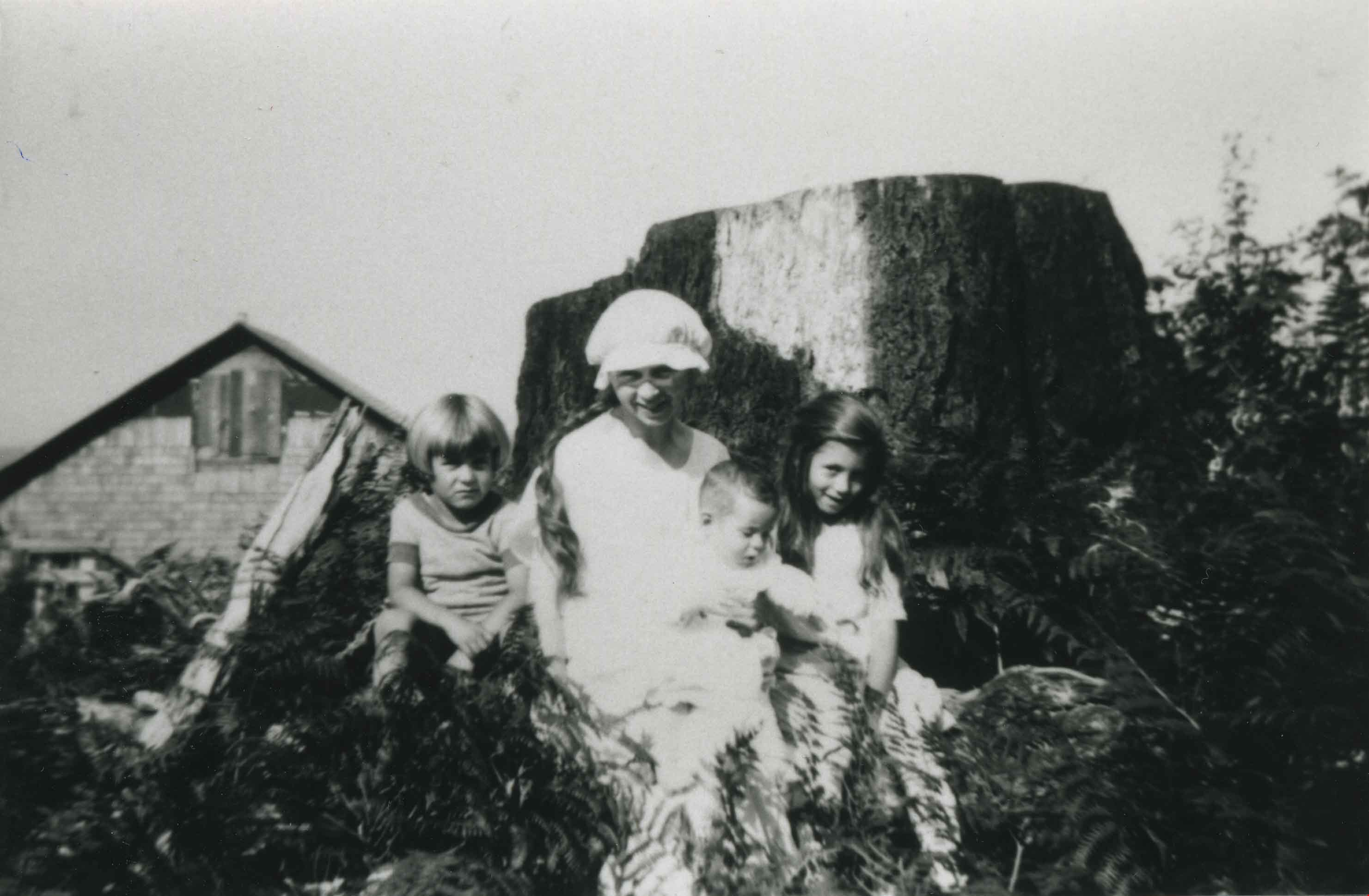
![Clearing for the shopping centre, [1958] thumbnail](/media/hpo/_Data/_Archives_Images/_Unrestricted/559/564-001.jpg?width=280)
Clearing for the shopping centre
https://search.heritageburnaby.ca/link/archivedescription85125
- Repository
- City of Burnaby Archives
- Date
- [1958]
- Collection/Fonds
- Ben Bradley collection
- Description Level
- Item
- Physical Description
- 1 photograph : b&w ; 8.2 x 11.5 cm
- Scope and Content
- Photograph of children climbing on a large tree stump on land being cleared for the Brentwood Mall.
- Repository
- City of Burnaby Archives
- Date
- [1958]
- Collection/Fonds
- Ben Bradley collection
- Physical Description
- 1 photograph : b&w ; 8.2 x 11.5 cm
- Description Level
- Item
- Record No.
- 564-001
- Access Restriction
- No restrictions
- Reproduction Restriction
- Reproduce for fair dealing purposes only
- Accession Number
- 2013-30
- Scope and Content
- Photograph of children climbing on a large tree stump on land being cleared for the Brentwood Mall.
- Subjects
- Buildings - Commercial
- Land Clearing
- Media Type
- Photograph
- Notes
- Transcribed title
- Note on verso reads: "Clearing for shopping centre"
- Street Address
- 4567 Lougheed Highway
- Planning Study Area
- Brentwood Area
Images
![Clearing for the shopping centre, [1958] thumbnail](/media/hpo/_Data/_Archives_Images/_Unrestricted/559/564-001.jpg)

Clearing Gough Family Lot
https://search.heritageburnaby.ca/link/archivedescription35486
- Repository
- City of Burnaby Archives
- Date
- 1912 (date of original), copied 1986
- Collection/Fonds
- Burnaby Historical Society fonds
- Description Level
- Item
- Physical Description
- 1 photograph : b&w ; 12.7 x 17.8 cm print
- Scope and Content
- Photograph of the Gough family and relatives clearing the lot for the family home on Nelson Avenue, Alta Vista. Identified in the photo (back row, centre) Donald Gough. Others in picture are aunts and uncles named Evans. Donald was the son of Agnes Gough and her husband William, who settled here…
- Repository
- City of Burnaby Archives
- Date
- 1912 (date of original), copied 1986
- Collection/Fonds
- Burnaby Historical Society fonds
- Subseries
- Pioneer Tales subseries
- Physical Description
- 1 photograph : b&w ; 12.7 x 17.8 cm print
- Description Level
- Item
- Record No.
- 204-344
- Access Restriction
- No restrictions
- Reproduction Restriction
- No known restrictions
- Accession Number
- BHS1988-03
- Scope and Content
- Photograph of the Gough family and relatives clearing the lot for the family home on Nelson Avenue, Alta Vista. Identified in the photo (back row, centre) Donald Gough. Others in picture are aunts and uncles named Evans. Donald was the son of Agnes Gough and her husband William, who settled here at 2119 Nelson Avenue (later 7126 Nelson Avenue).
- Subjects
- Land Clearing
- Names
- Evans Family
- Gough, Donald
- Media Type
- Photograph
- Notes
- Title based on contents of photograph
- Annotation at top of photograph reads, "Nelson & Victory Sts - 1912"
- Geographic Access
- Nelson Avenue
- Street Address
- 7126 Nelson Avenue
- Historic Neighbourhood
- Alta-Vista (Historic Neighbourhood)
- Planning Study Area
- Sussex-Nelson Area
Images

![Clearing land, [1910 or 1911] thumbnail](/media/hpo/_Data/_Archives_Images/_Unrestricted/487/487-038.jpg?width=280)
Clearing land
https://search.heritageburnaby.ca/link/archivedescription65900
- Repository
- City of Burnaby Archives
- Date
- [1910 or 1911]
- Collection/Fonds
- J.W. Phillips fonds
- Description Level
- Item
- Physical Description
- 1 photograph : b&w glass negative ; 15.5 x 11 cm
- Scope and Content
- Photograph of three men clearing land (most likely) on the Phillips family property. John George "George" Phillips and his father William James Phillips appear to be standing on running boards at the base of a large felled tree. The third man, sitting at the base of the stump, is unidentified.
- Repository
- City of Burnaby Archives
- Date
- [1910 or 1911]
- Collection/Fonds
- J.W. Phillips fonds
- Physical Description
- 1 photograph : b&w glass negative ; 15.5 x 11 cm
- Material Details
- Emulsion measures 15.5 x 11 cm on the glass; entire glass plate measures 16 x 12 cm
- Description Level
- Item
- Record No.
- 487-038
- Access Restriction
- No restrictions
- Reproduction Restriction
- No known restrictions
- Accession Number
- 2008-18
- Scope and Content
- Photograph of three men clearing land (most likely) on the Phillips family property. John George "George" Phillips and his father William James Phillips appear to be standing on running boards at the base of a large felled tree. The third man, sitting at the base of the stump, is unidentified.
- Subjects
- Land Clearing
- Media Type
- Photograph
- Photographer
- Phillips, James William "Jim"
- Notes
- Title based on contents of photograph
- Geographic Access
- Ellesmere Avenue
- Historic Neighbourhood
- Capitol Hill (Historic Neighbourhood)
- Planning Study Area
- Capitol Hill Area
Images
![Clearing land, [1910 or 1911] thumbnail](/media/hpo/_Data/_Archives_Images/_Unrestricted/487/487-038.jpg)