Narrow Results By
Creator
- Bancroft, Rose 1
- Burnett, David H. 1
- Burnett, Geoffrey K. 1
- Burnett & McGugan, Engineers and Surveyors 7
- Draper, William Nelson 1
- Forsyth, Mary 1
- Garden, Hermon and Burwell 2
- Garden, Hermon & Burwell 1
- Gauvreau, Narcisse B. 1
- Government of British Columbia - Department of Mines and Resources 1
- Government of Canada - Department of Mines - Geological Survey Branch 1
- Hill, Albert James 18
![All Saints Church, [ca.1910] thumbnail](/media/hpo/_Data/_BVM_Cartographic_Material/2003/2003_0083_0046_001.jpg?width=280)
All Saints Church
https://search.heritageburnaby.ca/link/museumdescription11924
- Repository
- Burnaby Village Museum
- Date
- [ca.1910]
- Collection/Fonds
- Ronald G. Scobbie collection
- Description Level
- Item
- Physical Description
- 1 plan : black ink and watercol. on paper ; 30.45 x 30.5 cm
- Scope and Content
- Item consists of building insurance plan of "All Saints Church / Lot "A" BK 29 DL 98 GP1 N.W.D.". Watling Street is idenfied to the north of the church building and Royal Oak Avenue to the west.
- Repository
- Burnaby Village Museum
- Collection/Fonds
- Ronald G. Scobbie collection
- Description Level
- Item
- Physical Description
- 1 plan : black ink and watercol. on paper ; 30.45 x 30.5 cm
- Material Details
- Scale 1 inch = 20 feet
- Scope and Content
- Item consists of building insurance plan of "All Saints Church / Lot "A" BK 29 DL 98 GP1 N.W.D.". Watling Street is idenfied to the north of the church building and Royal Oak Avenue to the west.
- Subjects
- Buildings - Religious - Churches
- Accession Code
- BV003.83.46
- Access Restriction
- No restrictions
- Reproduction Restriction
- No known restrictions
- Date
- [ca.1910]
- Media Type
- Cartographic Material
- Scan Resolution
- 600
- Scan Date
- 15-Jan-2021
- Scale
- 100
- Notes
- Transcribed title
- Note in pencil on verso reads: ""All Saints Church / Lot "A" BK 29 DL 98 / Scale 1 inch = 20 feet"
- Note in balck in on verso reads: "3704"
Images
![All Saints Church, [ca.1910] thumbnail](/media/hpo/_Data/_BVM_Cartographic_Material/2003/2003_0083_0046_001.jpg)
![Anglican Church, [ca.1910] thumbnail](/media/hpo/_Data/_BVM_Cartographic_Material/2003/2003_0083_0043_001.jpg?width=280)
Anglican Church
https://search.heritageburnaby.ca/link/museumdescription11921
- Repository
- Burnaby Village Museum
- Date
- [ca.1910]
- Collection/Fonds
- Ronald G. Scobbie collection
- Description Level
- Item
- Physical Description
- 1 plan : black ink and watercol. on paper ; 30.45 x 30.5 cm
- Scope and Content
- Item consists of building insurance plan of "Anglican Church / Lot 2 BK 37 DL69, GP.1, N.W.D. (15th Ave. (Dominion) is identified to the north of Lots 1, 2 and 3).
- Repository
- Burnaby Village Museum
- Collection/Fonds
- Ronald G. Scobbie collection
- Description Level
- Item
- Physical Description
- 1 plan : black ink and watercol. on paper ; 30.45 x 30.5 cm
- Material Details
- Scale 1 inch = 20 feet
- Scope and Content
- Item consists of building insurance plan of "Anglican Church / Lot 2 BK 37 DL69, GP.1, N.W.D. (15th Ave. (Dominion) is identified to the north of Lots 1, 2 and 3).
- Subjects
- Buildings - Religious - Churches
- Accession Code
- BV003.83.43
- Access Restriction
- No restrictions
- Reproduction Restriction
- No known restrictions
- Date
- [ca.1910]
- Media Type
- Cartographic Material
- Scan Resolution
- 600
- Scan Date
- 15-Jan-2021
- Scale
- 100
- Notes
- Transcribed title
- Note in pencil on verso reads: "Anglican Church / Lot 2 Bk 37 DL69 / 1"=20' "
- Note in balck in on verso reads: "3704"
Images
![Anglican Church, [ca.1910] thumbnail](/media/hpo/_Data/_BVM_Cartographic_Material/2003/2003_0083_0043_001.jpg)
Bancroft family subseries
https://search.heritageburnaby.ca/link/archivedescription63795
- Repository
- City of Burnaby Archives
- Date
- [1900]-1979
- Collection/Fonds
- Burnaby Historical Society fonds
- Description Level
- Subseries
- Physical Description
- Textual records and other materials
- Scope and Content
- Subseries consists of publications, correspondence and other miscellaneous papers relating to the Bancroft family's interests and work history. Topics include gardening, raising poultry, the Liberal government and the Royal Canadian Air Force. Also included in the subseries are photographs of the…
- Repository
- City of Burnaby Archives
- Date
- [1900]-1979
- Collection/Fonds
- Burnaby Historical Society fonds
- Subseries
- Bancroft family subseries
- Physical Description
- Textual records and other materials
- Description Level
- Subseries
- Accession Number
- BHS1986-44
- BHS2004-06
- Scope and Content
- Subseries consists of publications, correspondence and other miscellaneous papers relating to the Bancroft family's interests and work history. Topics include gardening, raising poultry, the Liberal government and the Royal Canadian Air Force. Also included in the subseries are photographs of the Bancroft family and friends and ephemera pertaining to agricultural farming and the air force.
- History
- Rose Croucher was born to Ann Eliza "Annie" (b. August 1861, d. 1962) and R. Coucher in January 1895. In 1907, the Croucher family moved to British Columbia. As a student, Rose studied geometrical drawing using Blair’s Canadian Drawing Series workbooks. On on February 21, 1914, Rose married James Oakes Bancroft in Vancouver, BC. Together they had three children: James A. (b. 1916 or 1917), Rosie (date unknown), and George E. (b. August 1927). The Bancroft family were poultry farmers throughout the early 1900s, transporting their farmed eggs from Burnaby to the Hudson’s Bay Company Vancouver using the British Columbia Electric Railway system. Rose Bancroft also served as Secretary-Treasurer of the Central Park Poultry Co-op Association in the 1920s until her husband's death in 1930 at the age of 42. In the late thirties and early forties, while James A. Bancroft was stationed in Calgary with the Royal Canadian Air Force, his younger siblings lived together with their mother and grandmother at 1963 21st Avenue in Burnaby. Rosie Bancroft studied French and English history in Social Studies in 1937; her brother George studied the seasons in General Science II in 1942. Rose died in 1965 at the age of 76.
- Media Type
- Textual Record
- Photograph
- Cartographic Material
- Creator
- Bancroft, Rose
- Notes
- MSS030, PC490, PC507, and MSS110
- Title based on creator and contents of subseries
Board of Railway Commissioners
https://search.heritageburnaby.ca/link/archivedescription396
- Repository
- City of Burnaby Archives
- Date
- 1909-1912
- Collection/Fonds
- City Council and Office of the City Clerk fonds
- Description Level
- File
- Physical Description
- Textual record, cartographic material, and architectural drawings
- Scope and Content
- File contains correspondence and reports related to the activities of the Board of Railway Commissioners such as the movement of stations, culvert work, and the maintenance of crossings. File also includes white linen plan and blueprint plans (4) of culverts at Cariboo Road and V.W. and Y.Rlwy Jun…
- Repository
- City of Burnaby Archives
- Date
- 1909-1912
- Collection/Fonds
- City Council and Office of the City Clerk fonds
- Physical Description
- Textual record, cartographic material, and architectural drawings
- Description Level
- File
- Record No.
- 2096
- Accession Number
- 2001-02
- Scope and Content
- File contains correspondence and reports related to the activities of the Board of Railway Commissioners such as the movement of stations, culvert work, and the maintenance of crossings. File also includes white linen plan and blueprint plans (4) of culverts at Cariboo Road and V.W. and Y.Rlwy Junction, 1911.
- Notes
- Plans/maps are located in file and have not been moved to map case.
Boundary Plan - Location for Burnaby Council of the West Boundary of Lots 161 and 175 Group One
https://search.heritageburnaby.ca/link/archivedescription8042
- Repository
- City of Burnaby Archives
- Date
- [1909]
- Collection/Fonds
- City Council and Office of the City Clerk fonds
- Description Level
- Item
- Physical Description
- Cartographic material
- Scope and Content
- Item consists of one plan on waxed linen with colour ink noting the western boundary of District Lots 161 and 175.
- Repository
- City of Burnaby Archives
- Date
- [1909]
- Collection/Fonds
- City Council and Office of the City Clerk fonds
- Physical Description
- Cartographic material
- Description Level
- Item
- Record No.
- 10997
- Accession Number
- 2001-02
- Scope and Content
- Item consists of one plan on waxed linen with colour ink noting the western boundary of District Lots 161 and 175.
- Media Type
- Cartographic Material
- Notes
- Located in map case.
![Broadview Presbyterian Church, [ca.1910] thumbnail](/media/hpo/_Data/_BVM_Cartographic_Material/2003/2003_0083_0049_001.jpg?width=280)
Broadview Presbyterian Church
https://search.heritageburnaby.ca/link/museumdescription11927
- Repository
- Burnaby Village Museum
- Date
- [ca.1910]
- Collection/Fonds
- Ronald G. Scobbie collection
- Description Level
- Item
- Physical Description
- 1 plan : black ink and watercol. on paper ; 30.45 x 30.5 cm
- Scope and Content
- Item consists of building insurance plan of "Broadview Presbyterian Church / Lot 6, BK 31, DL 69 / GP1 N.W.D." . Fourteenth Avenue (Manor) is identified to the north and Douglas Ave. to the east.
- Repository
- Burnaby Village Museum
- Collection/Fonds
- Ronald G. Scobbie collection
- Description Level
- Item
- Physical Description
- 1 plan : black ink and watercol. on paper ; 30.45 x 30.5 cm
- Material Details
- Scale 1 inch = 20 feet
- Scope and Content
- Item consists of building insurance plan of "Broadview Presbyterian Church / Lot 6, BK 31, DL 69 / GP1 N.W.D." . Fourteenth Avenue (Manor) is identified to the north and Douglas Ave. to the east.
- Subjects
- Buildings - Religious - Churches
- Accession Code
- BV003.83.49
- Access Restriction
- No restrictions
- Reproduction Restriction
- No known restrictions
- Date
- [ca.1910]
- Media Type
- Cartographic Material
- Scan Resolution
- 600
- Scan Date
- 15-Jan-2021
- Scale
- 100
- Notes
- Transcribed title
- Note in pencil on verso reads: "Broadview Presbyterian Church / Lot 6, BK 31, DL 69 / 1" = 20' "
- Note in balck in on verso reads: "3704"
Images
![Broadview Presbyterian Church, [ca.1910] thumbnail](/media/hpo/_Data/_BVM_Cartographic_Material/2003/2003_0083_0049_001.jpg)
Cameron Road
https://search.heritageburnaby.ca/link/archivedescription324
- Repository
- City of Burnaby Archives
- Date
- [1904]
- Collection/Fonds
- City Council and Office of the City Clerk fonds
- Description Level
- File
- Physical Description
- Textual record and cartographic material
- Scope and Content
- File contains Cameron Road Plan.
- Repository
- City of Burnaby Archives
- Date
- [1904]
- Collection/Fonds
- City Council and Office of the City Clerk fonds
- Physical Description
- Textual record and cartographic material
- Description Level
- File
- Record No.
- 2017
- Accession Number
- 2001-02
- Scope and Content
- File contains Cameron Road Plan.
- Media Type
- Textual Record
- Cartographic Material
- Notes
- Plans/maps are located in file and have not been moved to map case.
Cancellation of plan - Block 2, DL 77
https://search.heritageburnaby.ca/link/archivedescription1142
- Repository
- City of Burnaby Archives
- Date
- [Between 1890 - 1918]
- Collection/Fonds
- City Council and Office of the City Clerk fonds
- Description Level
- File
- Physical Description
- Textual record and cartographic material
- Scope and Content
- Files consists of cancellation of plan Block 2, DL 77 and two accompanied blueprints 434 (April 8, 1890) and 238 (December 30, 1887)
- Repository
- City of Burnaby Archives
- Date
- [Between 1890 - 1918]
- Collection/Fonds
- City Council and Office of the City Clerk fonds
- Physical Description
- Textual record and cartographic material
- Description Level
- File
- Record No.
- 2933
- Accession Number
- 2001-02
- Scope and Content
- Files consists of cancellation of plan Block 2, DL 77 and two accompanied blueprints 434 (April 8, 1890) and 238 (December 30, 1887)
- Media Type
- Textual Record
- Cartographic Material
- Notes
- Plan of Lot 77, group 1 NWD : M9-B-1-4. Plan of subdivision of blocks 2-6, lot 77, group 1 NWD : M9-B-1-5
Crossing - B.C. Electric Railway Co.
https://search.heritageburnaby.ca/link/archivedescription657
- Repository
- City of Burnaby Archives
- Date
- 1909-1913
- Collection/Fonds
- City Council and Office of the City Clerk fonds
- Description Level
- File
- Physical Description
- Textual record and cartographic material
- Scope and Content
- File contains correspondence and reports pertaining to crossings on B.C. Electric Railway lines at Cariboo, Hastings, Boundary, Gilley, Jubilee, McKay, and Patterson.
- Repository
- City of Burnaby Archives
- Date
- 1909-1913
- Collection/Fonds
- City Council and Office of the City Clerk fonds
- Physical Description
- Textual record and cartographic material
- Description Level
- File
- Record No.
- 2382
- Accession Number
- 2001-02
- Scope and Content
- File contains correspondence and reports pertaining to crossings on B.C. Electric Railway lines at Cariboo, Hastings, Boundary, Gilley, Jubilee, McKay, and Patterson.
- Media Type
- Textual Record
- Cartographic Material
- Notes
- Vancouver and Lulu Island Railway Westminster and Eburne Byrne Road Crossing at Station 355 : M9-A-6-5; Trapp Road Crossing at Station 425 : M9-A-6-6
Ditches and water courses
https://search.heritageburnaby.ca/link/archivedescription662
- Repository
- City of Burnaby Archives
- Date
- 1908
- Collection/Fonds
- City Council and Office of the City Clerk fonds
- Description Level
- File
- Physical Description
- Textual record and cartographic material
- Scope and Content
- File contains reports, correspondence, declarations and appeals related to the construction of ditches and water courses as well as the application to construct ditches made by Ida I. Dow, William Buckoll, and O. Goodacre. File also includes white linen plan of "Proposed Ditch in lot 153, G1, NWD…
- Repository
- City of Burnaby Archives
- Date
- 1908
- Collection/Fonds
- City Council and Office of the City Clerk fonds
- Physical Description
- Textual record and cartographic material
- Description Level
- File
- Record No.
- 2387
- Accession Number
- 2001-02
- Scope and Content
- File contains reports, correspondence, declarations and appeals related to the construction of ditches and water courses as well as the application to construct ditches made by Ida I. Dow, William Buckoll, and O. Goodacre. File also includes white linen plan of "Proposed Ditch in lot 153, G1, NWD" located at M9-B-3-20.
- Media Type
- Textual Record
- Cartographic Material
- Notes
- A map of Proposed Ditch in Lot 153 : M9-B-3-20
Ditches and water courses (Sprott)
https://search.heritageburnaby.ca/link/archivedescription668
- Repository
- City of Burnaby Archives
- Date
- 1908
- Collection/Fonds
- City Council and Office of the City Clerk fonds
- Description Level
- File
- Physical Description
- Textual records, cartographic material and architectural material
- Scope and Content
- File contains correspondence, certificates signed by the District Engineer attesting to the fact that ditches were constructed according to the Ditches and Waterworks Act, as well as notices to residents that ditches were to be built along their property. File also includes 2 blueprint plans and 1…
- Repository
- City of Burnaby Archives
- Date
- 1908
- Collection/Fonds
- City Council and Office of the City Clerk fonds
- Physical Description
- Textual records, cartographic material and architectural material
- Description Level
- File
- Record No.
- 2393
- Accession Number
- 2001-02
- Scope and Content
- File contains correspondence, certificates signed by the District Engineer attesting to the fact that ditches were constructed according to the Ditches and Waterworks Act, as well as notices to residents that ditches were to be built along their property. File also includes 2 blueprint plans and 1 linen map of DL 79.
- Notes
- Plans/maps are located in file and have not been moved to map case.
Ditches - Woolard v. Burnaby
https://search.heritageburnaby.ca/link/archivedescription670
- Repository
- City of Burnaby Archives
- Date
- 1904-1907
- Collection/Fonds
- City Council and Office of the City Clerk fonds
- Description Level
- File
- Physical Description
- Textual record and cartographic material
- Scope and Content
- File contains correspondence and court transcripts from the trial John Woolard v. Municipality of Burnaby which arose from charges brought against Burnaby for interfering with a ditch built by Woolard. File includes a blueprint plan of "Profile on Water Surface in Holland Road Ditch and Woollard's…
- Repository
- City of Burnaby Archives
- Date
- 1904-1907
- Collection/Fonds
- City Council and Office of the City Clerk fonds
- Physical Description
- Textual record and cartographic material
- Description Level
- File
- Record No.
- 2395
- Accession Number
- 2001-02
- Scope and Content
- File contains correspondence and court transcripts from the trial John Woolard v. Municipality of Burnaby which arose from charges brought against Burnaby for interfering with a ditch built by Woolard. File includes a blueprint plan of "Profile on Water Surface in Holland Road Ditch and Woollard's Ditch " (1904) and a linen plan of Woollard's and Hooland Road ditches (lot 155a, group 1).
- Media Type
- Textual Record
- Cartographic Material
- Notes
- Plans/maps are located in file and have not been moved to map case.
![Dundonald United Church, [ca.1910] thumbnail](/media/hpo/_Data/_BVM_Cartographic_Material/2003/2003_0083_0052_001.jpg?width=280)
Dundonald United Church
https://search.heritageburnaby.ca/link/museumdescription11930
- Repository
- Burnaby Village Museum
- Date
- [ca.1910]
- Collection/Fonds
- Ronald G. Scobbie collection
- Description Level
- Item
- Physical Description
- 1 plan : black ink and watercol. on paper ; 30.45 x 30.5 cm
- Scope and Content
- Item consists of a building insurance plan of "Dundonald United Church / Lots 9, 10 BK 28 DL 159 GP 1 / N.W.D.". Clinton Street is identified to the north of Lots nine and ten.
- Repository
- Burnaby Village Museum
- Collection/Fonds
- Ronald G. Scobbie collection
- Description Level
- Item
- Physical Description
- 1 plan : black ink and watercol. on paper ; 30.45 x 30.5 cm
- Material Details
- Scale 1 inch = 20 feet
- Scope and Content
- Item consists of a building insurance plan of "Dundonald United Church / Lots 9, 10 BK 28 DL 159 GP 1 / N.W.D.". Clinton Street is identified to the north of Lots nine and ten.
- Subjects
- Buildings - Religious - Churches
- Names
- Dundonald United Church
- Accession Code
- BV003.83.52
- Access Restriction
- No restrictions
- Reproduction Restriction
- No known restrictions
- Date
- [ca.1910]
- Media Type
- Cartographic Material
- Scan Resolution
- 600
- Scan Date
- 15-Jan-2021
- Scale
- 100
- Notes
- Transcribed title
- Note in pencil on verso reads: "_ _Church / Lots 9 & 10 BK 28 DL 159 / 1" = 20' "
- Note in black ink on verso reads: "3704"
Images
![Dundonald United Church, [ca.1910] thumbnail](/media/hpo/_Data/_BVM_Cartographic_Material/2003/2003_0083_0052_001.jpg)
Ephemera subseries
https://search.heritageburnaby.ca/link/archivedescription97408
- Repository
- City of Burnaby Archives
- Date
- 1893 (date of original)-2004
- Collection/Fonds
- Burnaby Historical Society fonds
- Description Level
- Subseries
- Physical Description
- Textual records and cartographic records
- Scope and Content
- Subseries consists of newspapers, printed material, publications, artworks, maps and other ephemera items collected or purchased by the Burnaby Historical Society for inclusion in their Community Archives.
- Repository
- City of Burnaby Archives
- Date
- 1893 (date of original)-2004
- Collection/Fonds
- Burnaby Historical Society fonds
- Subseries
- Ephemera subseries
- Physical Description
- Textual records and cartographic records
- Description Level
- Subseries
- Accession Number
- BHS1985-22
- BHS1986-01
- BHS1986-16
- BHS1986-43
- BHS1988-02
- BHS1988-12
- BHS1988-14
- BHS1989-09
- BHS1989-11
- BHS1989-14
- BHS1989-16
- BHS1991-26
- BHS1991-35
- BHS1991-40
- BHS1992-01
- BHS1994-09
- BHS1995-13
- BHS1995-17
- BHS1996-10
- BHS1997-06
- BHS1997-10
- BHS1999-04
- BHS1999-08
- BHS2000-12
- BHS2004-09
- BHS2004-11
- BHS2005-04
- BHS2005-05
- BHS2007-03
- BHS2007-04
- Scope and Content
- Subseries consists of newspapers, printed material, publications, artworks, maps and other ephemera items collected or purchased by the Burnaby Historical Society for inclusion in their Community Archives.
- Media Type
- Textual Record
- Cartographic Material
- Notes
- Title based on content of subseries
- PC212, PC219, PC472, PC598, MSS005, MSS010, MSS034, MSS038, MSS046, MSS076, MSS081, MSS090, MSS111, MSS114, MSS119, MSS195
Gunn Road diversion (Banfield, J.J.)
https://search.heritageburnaby.ca/link/archivedescription319
- Repository
- City of Burnaby Archives
- Date
- 1905-1911
- Collection/Fonds
- City Council and Office of the City Clerk fonds
- Description Level
- File
- Physical Description
- Textual record and cartographic material
- Scope and Content
- File contains records, including blueprint, related to the proposed diversion of Gunn Road.
- Repository
- City of Burnaby Archives
- Date
- 1905-1911
- Collection/Fonds
- City Council and Office of the City Clerk fonds
- Physical Description
- Textual record and cartographic material
- Description Level
- File
- Record No.
- 2010
- Accession Number
- 2001-02
- Scope and Content
- File contains records, including blueprint, related to the proposed diversion of Gunn Road.
- Media Type
- Textual Record
- Cartographic Material
- Notes
- White linen plan : Diversion of Gunn Road Lots 10 and 4 Group One" : M9-A-3-17.
Hastings Road
https://search.heritageburnaby.ca/link/archivedescription458
- Repository
- City of Burnaby Archives
- Date
- 1908-1909
- Collection/Fonds
- City Council and Office of the City Clerk fonds
- Description Level
- File
- Physical Description
- Textual record and cartographic material
- Scope and Content
- File consists of correspondence and reports arising from a survey of Hastings Road and two maps associated with the correspondence. One map is of Hastings Road through Westminster District and the the other is a tracing of Douglas Road from original notes of the Royal Engineers.
- Repository
- City of Burnaby Archives
- Date
- 1908-1909
- Collection/Fonds
- City Council and Office of the City Clerk fonds
- Physical Description
- Textual record and cartographic material
- Description Level
- File
- Record No.
- 2163
- Accession Number
- 2001-02
- Scope and Content
- File consists of correspondence and reports arising from a survey of Hastings Road and two maps associated with the correspondence. One map is of Hastings Road through Westminster District and the the other is a tracing of Douglas Road from original notes of the Royal Engineers.
- Media Type
- Textual Record
- Cartographic Material
- Notes
- A map of Hastings Road through N. West (1909) : M9-B-1-1; "Tracing of original notes from Royal Engineers of Douglas Road" : M9-B-1-2
Hastings Road diversion
https://search.heritageburnaby.ca/link/archivedescription322
- Repository
- City of Burnaby Archives
- Date
- [1906]
- Collection/Fonds
- City Council and Office of the City Clerk fonds
- Description Level
- File
- Physical Description
- Textual record and cartographic material
- Scope and Content
- File contains record of surveys done for Hastings Road diversion. White linen plans in map case.
- Repository
- City of Burnaby Archives
- Date
- [1906]
- Collection/Fonds
- City Council and Office of the City Clerk fonds
- Physical Description
- Textual record and cartographic material
- Description Level
- File
- Record No.
- 2015
- Accession Number
- 2001-02
- Scope and Content
- File contains record of surveys done for Hastings Road diversion. White linen plans in map case.
- Media Type
- Textual Record
- Cartographic Material
- Notes
- Survey of Hastings Road from Hastings Townsite to Still Creek : M9-A-3-2; M9-A-3-7
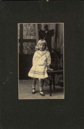
Kitty Hill
https://search.heritageburnaby.ca/link/archivedescription66567
- Repository
- City of Burnaby Archives
- Date
- 1904
- Collection/Fonds
- Peers Family and Hill Family fonds
- Description Level
- Item
- Physical Description
- 1 photograph : b&w + 1 watercolour painting
- Scope and Content
- Photograph is a portrait of Kitty Hill, posing next to a high-back chair. Accompanying the photograph is a watercolour painting that was based on this photograph, done on a linen backing.
- Repository
- City of Burnaby Archives
- Date
- 1904
- Collection/Fonds
- Peers Family and Hill Family fonds
- Physical Description
- 1 photograph : b&w + 1 watercolour painting
- Description Level
- Item
- Record No.
- 477-1181
- Access Restriction
- No restrictions
- Reproduction Restriction
- No known restrictions
- Accession Number
- 2007-12
- Scope and Content
- Photograph is a portrait of Kitty Hill, posing next to a high-back chair. Accompanying the photograph is a watercolour painting that was based on this photograph, done on a linen backing.
- Media Type
- Photograph
- Graphic Material
- Notes
- Title based on contents of photograph
Images

Love and Leonard land records series
https://search.heritageburnaby.ca/link/museumdescription18838
- Repository
- Burnaby Village Museum
- Date
- 1893-1962
- Collection/Fonds
- Love family fonds
- Description Level
- Series
- Physical Description
- 5 plans + 8 cm of textual records
- Scope and Content
- Series consists of land deeds, land sale agreements, documents regarding payment and survey and subdivision plans. Records refer to the Love family property in District Lot 25, the Leonard family property in District Lot 352 and other lots in Burnaby.
- Repository
- Burnaby Village Museum
- Collection/Fonds
- Love family fonds
- Description Level
- Series
- Physical Description
- 5 plans + 8 cm of textual records
- Scope and Content
- Series consists of land deeds, land sale agreements, documents regarding payment and survey and subdivision plans. Records refer to the Love family property in District Lot 25, the Leonard family property in District Lot 352 and other lots in Burnaby.
- Accession Code
- BV992.26
- BV012.31
- Date
- 1893-1962
- Media Type
- Textual Record
- Cartographic Material
- Notes
- Title based on contents of series
Love family fonds
https://search.heritageburnaby.ca/link/museumdescription10098
- Repository
- Burnaby Village Museum
- Date
- 1881-1971
- Collection/Fonds
- Love family fonds
- Description Level
- Fonds
- Physical Description
- 11 cm of textual records + 44 photographs + 5 plans
- Scope and Content
- Fonds consists of family records including photographs, land sale records, agreements and plans as well as estate records, vital event documentation and correspondence. Records pertain to members of the Love family including the Parkers, Hughes and Leonards. Fonds has been arranged in the followin…
- Repository
- Burnaby Village Museum
- Collection/Fonds
- Love family fonds
- Description Level
- Fonds
- Physical Description
- 11 cm of textual records + 44 photographs + 5 plans
- Scope and Content
- Fonds consists of family records including photographs, land sale records, agreements and plans as well as estate records, vital event documentation and correspondence. Records pertain to members of the Love family including the Parkers, Hughes and Leonards. Fonds has been arranged in the following series: 1) Love and Leonard land records 2) Love family vital events and correspondence 3) Love family photographs
- History
- Jesse Love was born in Swindon, England in 1847 and left England to work on a dairy farm in the Toronto area. While working on the farm in Toronto, he met Martha Leonard who he married in 1879. Martha was born on February 3, 1858 in Bedfordshire, England and had come to Canada with her parents George and Ann Leonard. While living in Toronto, Jesse and Martha had two children, George born March 22, 1880 and Annie Elizabeth on August 24, 1881. About one year after Annie was born, the Love family moved to North Dakota to grow wheat. While living there, they had two more children, Henry who was born August 24, 1883 and Edith Minnie born October 9, 1885. The family decided to move further west after hearing about the fairer weather conditions from Martha’s father, George Leonard, who had settled in Vancouver in 1885. On May 23, 1887, Jesse, Martha and their four children arrived in Vancouver after travelling across Canada from Winnipeg on the first transcontinental train. The Loves made their home in Vancouver while Jesse helped clear land on Granville Street. Their fifth child, Thomas Robert was born on September 17, 1887 and soon after, the family moved to Lulu Island in Richmond where they lived growing vegetables and selling them to Vancouver hotels. While living and farming on Lulu island, the couple had two more girls, Martha (Dot or Dorothy) born on December 17, 1889 and Sarah Marie, born February 8, 1892. On October 6, 1893 an agreement was signed by Jesse Love to purchase 14.52 acres of land from Joseph C. Armstrong. The acreage covered the north east section of District Lot 25 within the newly incorporated District of the Municipality of Burnaby. It was here where the original Love house was built (between October 1893 and April 15, 1894) by Jesse Love with the help of local builder George Salt and father in law, George Leonard. The house consisted of an entrance hall, dining room, lean to kitchen, master bedroom and three bedrooms upstairs. A road was constructed and named Cumberland in 1905 and ran from District Lot 25 through to District Lot 11. The address for the Love home was 1390 Cumberland Road and in the early 1960’s the address was renumbered 7651 Cumberland Street. On the land surrounding the house, Jesse Love planted an orchard along with strawberries and raspberries which he sold at the Fraser Valley Market, T.S. Anandale’s Grocery Store in New Westminster and to hotels around Vancouver. Jesse Love served on the Burnaby School Board and also as a District Councillor in 1901 and from 1904-1907. While living in the house, Jesse and Martha had four more children, Phoebe Leonard, born April 15, 1894, Esther, born August 28, 1896, John Leonard, born June 7, 1899 and Hannah Victoria (also known as Girlie) who was born May 12, 1902. In 1918, at the age of 31 years, Thomas Robert Love fell ill due to an influenza epidemic and died on November 23, 1918. Following their son’s death, Martha Love became weak and on August 24, 1920, she passed away. By this time, Jesse had sold off a large percentage of his land and his youngest daughter, Girlie decided to stay on to live and care for him. Since the house was too large for just the two of them, Jesse invited any other children to return and share the residence. For a while his son, George and his wife joined them. In 1925 Jesse’s daughter Sarah Parker (nee Love), her husband William Michael Norton Parker and their three children, Albert “Bert” (1915-2011), William Charles “Bill” and Elsie Roberta moved from their home at 1319 Newcombe Street to join Jesse and Girlie in the Love family home on Cumberland. Jesse Love died in 1928 after which Sarah and William Parker purchased the Love family farmhouse and property. William Michael Parker, died in 1961 and Sarah Parker continued to live in the Love family farmhouse until 1966 when she sold it to her daughter Elsie and husband John Hughes. Elsie and John Hughes had four children, John Jr., Ann, Brent and Merle. The Hughes lived in the Love family house until August 1971. In 1988 the Love family farmhouse house was donated to the Burnaby Village Museum and moved to the site of Burnaby Village Museum. The interior of the main floor and exterior of the house went through an extensive restoration process. In 1997, restoration of the kitchen was completed and opened to the public. After the completion of the hallway, dining room, main floor bedroom and parlour, the Love farmhouse exhibit opened on November 29, 1998 with an open invitation to the public and extended members of the Love family.
- Responsibility
- Love Family
- Accession Code
- HV979.40
- BV985.3136
- BV988.45
- BV989.3
- BV992.15
- BV992.26
- BV992.34
- BV000.45
- BV008.20
- BV012.31
- BV019.3
- BV019.8
- Date
- 1881-1971
- Media Type
- Textual Record
- Photograph
- Cartographic Material
- Arrangement
- Fonds has been arranged by record type and original order provided by members of the Love family.
- Notes
- Title based on contents of fonds
- See also Burnaby Village Museum fonds - Jesse Love farmhouse series