Narrow Results By
Subject
- Buildings - Commercial 2
- Buildings - Industrial 2
- Documentary Artifacts - Maps 1
- Events 1
- Events - Openings 1
- First Nations reserves - British Columbia 1
- Geographic Features - Roads 1
- Government - Federal Government 1
- Government - Local Government 2
- Government - Provincial Government 1
- Indigenous peoples - Indian Territory 1
- Officials - Mayors and Reeves 1

Subdivision plans in New Westminster District Group 1 – Burnaby, Vancouver and map - Canada Department of Mines
https://search.heritageburnaby.ca/link/museumdescription6994
- Repository
- Burnaby Village Museum
- Date
- 1890-1909
- Collection/Fonds
- Burnaby Village Museum Map collection
- Description Level
- File
- Physical Description
- 1 plan : graphite on paper + 2 plans : black ink on paper + 1 map : col. on paper mounted on 2 sides of cardboard 76 x 102 cm
- Scope and Content
- Item consists of a large board with one New Westminster District subdivision plan mounted on one side and two New Westminster District subdivision plans and one colour map mounted on the other side. Side A: 1. "Plan / of Subdivision of / Blocks 2, 3, 4, 5, 6 / Lot 77 / Group 1 / New Westminster D…
- Repository
- Burnaby Village Museum
- Collection/Fonds
- Burnaby Village Museum Map collection
- Description Level
- File
- Physical Description
- 1 plan : graphite on paper + 2 plans : black ink on paper + 1 map : col. on paper mounted on 2 sides of cardboard 76 x 102 cm
- Material Details
- Scales 1:720 and 1:1200 and 1:.00001578
- Scope and Content
- Item consists of a large board with one New Westminster District subdivision plan mounted on one side and two New Westminster District subdivision plans and one colour map mounted on the other side. Side A: 1. "Plan / of Subdivision of / Blocks 2, 3, 4, 5, 6 / Lot 77 / Group 1 / New Westminster District / BC. / Scale 100 feet = 1 inch", "Deposited 8th day / of April 1890 / Mowileg [sic] / Dist. Regt". Plan is drawn in graphite with annotations: "AB_Parts_lettered_are_lots_in / the_different_subdivisions" / "Owners: / James E. Hall / P.S.Cabilan [sic] by his attorney Joseph Hall / Joseph Hall / Eliza J. Shannon / John Harrison"; "This plan is correct and is prepared under the / provisions of the Land Registry Act" ; signed by: "Gordon Herman & Burwell / Dominion & Provincial Land Surveryors / Vancouver March 19th/90" . Plan is initialed by: "RB" [sic] (in blue pencil crayon) and measures: 99.5 x 65 cm (Geographic location: Burnaby) Side B: 1. Map titled "Canada / Department of Mines / Geological Survey Branch" / "Hon.W Templeton, Minister / A.P. Low, Deputy Minister / R.W. Brock, Acting Director", Vol. XXXI, Plate I / Compiled under the direction of / James White, F.R.G.S. Geographer /Dep. of Interior". Note above map reads: "To illustrate Mr. James Barrowman's report as Delegate at the Excursion - meeting of the Canadian Mining Institute", "The instiitution of Mining Engineers / Transactions 1908 - 1909", "The Mining Institute of Scotland / Transactions 1908-1909". Map identifies minerals and includes a Legend and Scale: 100 miles = 1 inch 2. "Plan / of Subdivision of / Lot 4 / of Subdivision of / Lot 87. Gr. 1 / New Westminster District / Scale 60' = 1in." Plan is initialed by: "RB" [sic] along with a note "also Board / 48" (in blue pencil crayon) (Geographic location: Burnaby) 3. Plan of "Lot 335 / G. 1" west of Boundary Road and north of River Road - Vancouver. (Geographic location: Vancouver)
- Publisher
- The Mining Institute of Scotland
- Geographic Access
- Vancouver
- Accession Code
- HV977.93.25
- Access Restriction
- No restrictions
- Reproduction Restriction
- No known restrictions
- Date
- 1890-1909
- Media Type
- Cartographic Material
- Scan Resolution
- 300
- Scale
- 72
- Notes
- Title based on contents of file
- Scale is measured in feet and miles.
- The term "Lot" often refers to "District Lot"
Images


Burnaby Advisory Planning Commission records
https://search.heritageburnaby.ca/link/archivedescription82740
- Repository
- City of Burnaby Archives
- Date
- [1971-1996]
- Collection/Fonds
- Hazel Simnett collection
- Description Level
- File
- Physical Description
- 1 file of textual records ; 1 map ; 1 pin
- Scope and Content
- File consists of three letters, one envelope, a booklet, a map, a pin and a business card. The first letter found in the envelope from the Department of the Municipal Clerk is addressed to Hazel Simnett and approves her appointment to the Advisory Planning Commission in 1993. The second letter date…
- Repository
- City of Burnaby Archives
- Date
- [1971-1996]
- Collection/Fonds
- Hazel Simnett collection
- Physical Description
- 1 file of textual records ; 1 map ; 1 pin
- Description Level
- File
- Record No.
- MSS167-010
- Accession Number
- 2013-22
- Scope and Content
- File consists of three letters, one envelope, a booklet, a map, a pin and a business card. The first letter found in the envelope from the Department of the Municipal Clerk is addressed to Hazel Simnett and approves her appointment to the Advisory Planning Commission in 1993. The second letter dated March 17, 1995 is addressed to Hazel Simnett and approves her reappointment to the Advisory Planning Commission. The booklet is of the Burnaby Procedure Bylaw 1971 (bylaw number 6023 to regulate the proceedings of the Municipal Council of The Corporation of the District of Burnaby). The map is a street map of the Burnaby Planning & Building Department from 1992. The second letter is typewritten by Hazel Simnett to Mayor W. Copeland in 1996 regarding her resignation from the Advisory Planning Commission. The pin reads: "Burnaby Advisory Planning Commission". The business card is of Donald G. Stenson, Director Planning and Building of the Burnaby Planning and Building Department.
- Media Type
- Textual Record
- Cartographic Material
- Notes
- Title based on note accompanying file
- Simnett political papers series
Information for Harold Winch biography
https://search.heritageburnaby.ca/link/museumdescription3647
- Repository
- Burnaby Village Museum
- Date
- 1935-2003
- Collection/Fonds
- Harold Edward Winch collection
- Description Level
- File
- Physical Description
- 1 folder of textual records + 1 photograph : col.
- Scope and Content
- File consists of records relating to the development of a biography of Harold Winch, including newspaper clippings, Co-operative Commonwealth Federation (CCF) publicity material, and a photograph of the dedication of MacInnis Park in Vancouver, including Glen Clark, MLA.
- Repository
- Burnaby Village Museum
- Collection/Fonds
- Harold Edward Winch collection
- Description Level
- File
- Physical Description
- 1 folder of textual records + 1 photograph : col.
- Scope and Content
- File consists of records relating to the development of a biography of Harold Winch, including newspaper clippings, Co-operative Commonwealth Federation (CCF) publicity material, and a photograph of the dedication of MacInnis Park in Vancouver, including Glen Clark, MLA.
- Subjects
- Government - Provincial Government
- Accession Code
- BV013.12.4
- Date
- 1935-2003
- Media Type
- Photograph
- Textual Record
- Notes
- Title based on contents of file
Mayor Bill Copeland
https://search.heritageburnaby.ca/link/archivedescription97391
- Repository
- City of Burnaby Archives
- Date
- 1992-2002
- Collection/Fonds
- Burnaby NewsLeader photograph collection
- Description Level
- File
- Physical Description
- 17 photographs (tiff) : b&w
- Scope and Content
- File contains photographs of or related to Mayor Bill Copeland from throughout his life and career (primarily 1992-1996) that were collected for a memorial feature. Photographs depict Copeland at Burnaby events acting as mayor at events and ceremonies, including: receiving the new city seal in 1992…
- Repository
- City of Burnaby Archives
- Date
- 1992-2002
- Collection/Fonds
- Burnaby NewsLeader photograph collection
- Physical Description
- 17 photographs (tiff) : b&w
- Description Level
- File
- Record No.
- 535-2766
- Access Restriction
- No restrictions
- Reproduction Restriction
- No restrictions
- Accession Number
- 2018-12
- Scope and Content
- File contains photographs of or related to Mayor Bill Copeland from throughout his life and career (primarily 1992-1996) that were collected for a memorial feature. Photographs depict Copeland at Burnaby events acting as mayor at events and ceremonies, including: receiving the new city seal in 1992; opening a new housing co-op on Bellwood Avenue; unveiling a plaque for Drs. Blythe and Violet Eagles in Deer Lake Park; and cutting the ribbon at the opening of the Station Square Save-On-Foods and the aftermath of the roof collapse.
- Media Type
- Photograph
- Notes
- Title based on caption
- Collected by editorial for use in a September 2002 issue of the Burnaby NewsLeader
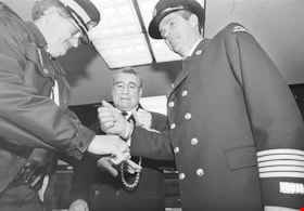
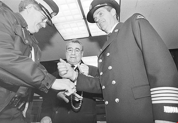
- Caption from metadata for 535-2766-1: "Bill Copeland and former Burnaby fire chief Wayne Brassington are "arrested" at City Hall to raise money for the Cancer Society, in 1996."
- Caption from metadata for 535-2766-2: "Bill Copeland is presented with a "birthday cake" celebrating Burnaby's centennial, in 1992, by Rose Vaughan, 101."
- Caption from metadata for 535-2766-3: "Bill Copeland tries out the computer touch screen at the grand opening of the newly refurbished CW Parker Carousel, at Burnaby Village Museum in April, 1995."
- Caption from metadata for 535-2766-4: "Bill Copeland is presented with Burnaby's new city seal by former premier, Mike Harcourt, part of the city's centennial celebration, in 1992."
- Caption from metadata for 535-2766-6: "Mayor Bill and the late Rudy Spence toast Ellen Betts at a diner honoring her longtime volunteer service with the Burnaby Arts Council, in 1995."
- Caption from metadata for 535-2766-7: "Copeland is congratulated on his re-election as Mayor, in 1993."
- Caption from metadata for 535-2766-8: "Mayor Bill laces up to promote a fitness challenge at Burnaby City Hall, in 1994."
- Caption from metadata for 535-2766-9: "Mayor Bill helps work the phones to promote a Chamber of Commerce membership drive, in 1993."
- Caption from metadata for 535-2766-10: "Mayor Bill helps unveil a plaque honoring doctors Blythe and Violet Eagles, at Deer Lake Park, in 1994."
- Caption from metadata for 535-2766-11: "Mayor Bill opens a new housing co-op on Bellwood Ave., with help from Hedy Fry and former MLA, Barry Gray."
- Caption from metadata for 535-2766-12: "Mayor Bill Copeland briefs the media after the Save-On Foods collapse at Station Square."
- Caption from metadata for 535-2766-13: "Mayor Bill Copeland, Jim Pattison, and other local dignitaries, are all smiles at the official opening of the new Save-On Foods at Station Square. But shortly after the ribbon-cutting ceremony, the new store's roof collapsed."
- Caption from metadata for 535-2766-15: "Mayor Bill tries out a vegetarian plate at the City Hall cafeteria, in 1996."
- Caption from metadata for 535-2766-16: "Bill Copeland celebrates his victory in a water pistol "showdown" against rival mayor, the late Len Trabouley, from Port Coquitlam, in 1992."
- Caption from metadata for 535-2766-17: "Even after he was confined to a wheelchair, following his illness, Bill Copeland continued to attend various city functions."
Images
![Political photographs, [1938-1990], predominant 1938-1953 thumbnail](/media/hpo/_Data/_BVM_Images/2013/2013_0012_0006_001.jpg?width=280)
Political photographs
https://search.heritageburnaby.ca/link/museumdescription3649
- Repository
- Burnaby Village Museum
- Date
- [1938-1990], predominant 1938-1953
- Collection/Fonds
- Harold Edward Winch collection
- Description Level
- File
- Physical Description
- 35 photographs : b&w + col. prints + slides
- Scope and Content
- File consists of photographs relating to Winch's political career, including professional portraits of Harold Winch, tourist photographs of Ottawa, and photographs of Winch with New Democratic Party (NDP) colleagues Dave Barrett (Premier of British Columbia, 1972-1975; also served as MLA and MP) an…
- Repository
- Burnaby Village Museum
- Collection/Fonds
- Harold Edward Winch collection
- Description Level
- File
- Physical Description
- 35 photographs : b&w + col. prints + slides
- Scope and Content
- File consists of photographs relating to Winch's political career, including professional portraits of Harold Winch, tourist photographs of Ottawa, and photographs of Winch with New Democratic Party (NDP) colleagues Dave Barrett (Premier of British Columbia, 1972-1975; also served as MLA and MP) and Dave Stupich (served as MLA and MP). Includes a photograph taken by photographer Ken McAllister of members of the CCF (Co-operative Commonwealth Federation) standing outside of the British Columbia Legislature [ca. 1941].
- Subjects
- Government - Federal Government
- Accession Code
- BV013.12.6
- Access Restriction
- No restrictions
- Reproduction Restriction
- May be restricted by third party rights
- Date
- [1938-1990], predominant 1938-1953
- Media Type
- Photograph
- Scan Resolution
- 600
- Scan Date
- 2023-04-14
- Photographer
- McAllister, Kenneth "Ken"
- Notes
- Title based on contents of file
- Annotation in blue ink on recto of photograph of CCF members [ca. 1941] includes names of people identified; "Arthur Tuenue, Colin Cameron, Laura Jamieson, Grant MacNeil / Wallis Lefeaux, Sam Guthrie, Bernard Webber, / Front: Bert Herridge, Grace MacInnis, Bert Gargrave, Harold Winch, Gretchen Steeves, Len Shepherd, Ernie Winch"
Images
![Political photographs, [1938-1990], predominant 1938-1953 thumbnail](/media/hpo/_Data/_BVM_Images/2013/2013_0012_0006_001.jpg)
4200 Phillips Ave
https://search.heritageburnaby.ca/link/archivedescription94317
- Repository
- City of Burnaby Archives
- Date
- September 1994
- Collection/Fonds
- Grover, Elliott & Co. Ltd. fonds
- Description Level
- File
- Physical Description
- 24 photographs : col. negatives ; 35 mm
- Scope and Content
- Photographs of the exterior of a single-storey industrial building located at 4200 Phillips Avenue - an address that no longer exists.
- Repository
- City of Burnaby Archives
- Date
- September 1994
- Collection/Fonds
- Grover, Elliott & Co. Ltd. fonds
- Physical Description
- 24 photographs : col. negatives ; 35 mm
- Description Level
- File
- Record No.
- 622-102
- Access Restriction
- No restrictions
- Reproduction Restriction
- No restrictions
- Accession Number
- 2017-39
- Scope and Content
- Photographs of the exterior of a single-storey industrial building located at 4200 Phillips Avenue - an address that no longer exists.
- Subjects
- Buildings - Industrial
- Media Type
- Photograph
- Notes
- Transcribed title
- Title transcribed from envelope photographs were originally housed in
- File no. 94-329-B
- Photographer identified as "J.C."
- Geographic Access
- Phillips Avenue
- Historic Neighbourhood
- Lozells (Historic Neighbourhood)
- Planning Study Area
- Government Road Area
7260 Winston St
https://search.heritageburnaby.ca/link/archivedescription93887
- Repository
- City of Burnaby Archives
- Date
- April 1993
- Collection/Fonds
- Grover, Elliott & Co. Ltd. fonds
- Description Level
- File
- Physical Description
- 36 photographs : col. negatives ; 35 mm
- Scope and Content
- Photographs of the exterior and parking lot of Smith Paper, located at 7260 Winston Street.
- Repository
- City of Burnaby Archives
- Date
- April 1993
- Collection/Fonds
- Grover, Elliott & Co. Ltd. fonds
- Physical Description
- 36 photographs : col. negatives ; 35 mm
- Description Level
- File
- Record No.
- 622-070
- Access Restriction
- No restrictions
- Reproduction Restriction
- No restrictions
- Accession Number
- 2017-39
- Scope and Content
- Photographs of the exterior and parking lot of Smith Paper, located at 7260 Winston Street.
- Subjects
- Buildings - Commercial
- Media Type
- Photograph
- Notes
- Transcribed title
- Title transcribed from envelope photographs were originally housed in
- File no. 93-175-B
- Photographer identified as "K.H."
- Geographic Access
- Winston Street
- Street Address
- 7260 Winston Street
- Historic Neighbourhood
- Lozells (Historic Neighbourhood)
- Planning Study Area
- Government Road Area
7260 Winston St.
https://search.heritageburnaby.ca/link/archivedescription94312
- Repository
- City of Burnaby Archives
- Date
- June 1994
- Collection/Fonds
- Grover, Elliott & Co. Ltd. fonds
- Description Level
- File
- Physical Description
- 49 photographs : col. negatives ; 35 mm
- Scope and Content
- Photographs of the exterior of Unisource, located at 7260 Winston Street.
- Repository
- City of Burnaby Archives
- Date
- June 1994
- Collection/Fonds
- Grover, Elliott & Co. Ltd. fonds
- Physical Description
- 49 photographs : col. negatives ; 35 mm
- Description Level
- File
- Record No.
- 622-097
- Access Restriction
- No restrictions
- Reproduction Restriction
- No restrictions
- Accession Number
- 2017-39
- Scope and Content
- Photographs of the exterior of Unisource, located at 7260 Winston Street.
- Subjects
- Buildings - Industrial
- Media Type
- Photograph
- Notes
- Transcribed title
- Title transcribed from envelope photographs were originally housed in
- File no. 94-214-B
- Photographer identified as "K.H."
- Geographic Access
- Winston Street
- Street Address
- 7260 Winston Street
- Historic Neighbourhood
- Lozells (Historic Neighbourhood)
- Planning Study Area
- Government Road Area
7973-7993 Enterprise St
https://search.heritageburnaby.ca/link/archivedescription94296
- Repository
- City of Burnaby Archives
- Date
- December 1993
- Collection/Fonds
- Grover, Elliott & Co. Ltd. fonds
- Description Level
- File
- Physical Description
- 46 photographs : col. negatives ; 35 mm
- Scope and Content
- Photographs of the commercial complex located at 7973-7993 Enterprise Street.
- Repository
- City of Burnaby Archives
- Date
- December 1993
- Collection/Fonds
- Grover, Elliott & Co. Ltd. fonds
- Physical Description
- 46 photographs : col. negatives ; 35 mm
- Description Level
- File
- Record No.
- 622-081
- Access Restriction
- No restrictions
- Reproduction Restriction
- No restrictions
- Accession Number
- 2017-39
- Scope and Content
- Photographs of the commercial complex located at 7973-7993 Enterprise Street.
- Media Type
- Photograph
- Notes
- Transcribed title
- Title transcribed from envelope photographs were originally housed in
- File no. 93-464-B
- Photographer identified as "K.H."
- Geographic Access
- Enterprise Street
- Street Address
- 7973 Enterprise Street
- 7993 Enterprise Street
- Historic Neighbourhood
- Lozells (Historic Neighbourhood)
- Planning Study Area
- Government Road Area
![Survey and Subdivision plans in New Westminster District Group 2 - Surrey, ʷməθkʷəy̓əm (Musqueam) Indian Reserve, [190-] thumbnail](/media/hpo/_Data/_BVM_Cartographic_Material/1977/1977_0093_0086_001.jpg?width=280)
Survey and Subdivision plans in New Westminster District Group 2 - Surrey, ʷməθkʷəy̓əm (Musqueam) Indian Reserve
https://search.heritageburnaby.ca/link/museumdescription7055
- Repository
- Burnaby Village Museum
- Date
- [190-]
- Collection/Fonds
- Burnaby Village Museum Map collection
- Description Level
- File
- Physical Description
- 12 plans : graphite and ink on paper and linen; various sizes mounted on 2 sides of cardboard 76 x 102 cm
- Scope and Content
- File consists of a large board with twelve plans (six plans mounted on each side). All plans are located in New Westminster District, Group 2, covering geographic areas within Surrey. Side A: 1. Plan : black ink on paper ; 20.5 x 57.5 cm. Title reads: "Extension of Tram Line / Hospital to Distill…
- Repository
- Burnaby Village Museum
- Collection/Fonds
- Burnaby Village Museum Map collection
- Description Level
- File
- Physical Description
- 12 plans : graphite and ink on paper and linen; various sizes mounted on 2 sides of cardboard 76 x 102 cm
- Scope and Content
- File consists of a large board with twelve plans (six plans mounted on each side). All plans are located in New Westminster District, Group 2, covering geographic areas within Surrey. Side A: 1. Plan : black ink on paper ; 20.5 x 57.5 cm. Title reads: "Extension of Tram Line / Hospital to Distillery St." Scales: Hor: 100 feet = 1 inch; Vert: 20 feet = 1 inch. tram line, hospital to distillery street; 2. Plan : black ink on linen ; 55 x 46.5 cm. (no title). Plan covers New Westminster District, Group 2, Lots 1,2, 3,4, A and B and the ʷməθkʷəy̓əm (Musqueam) Indian Reserve (1868).along the south shore of the Fraser River opposite City of New Westminster. Portion of land is highlighted in blue along the west border of the "ʷməθkʷəy̓əm (Musqueam) Indian Reserve" and between Lot 2 and Lot 1 and survey lines identified as "Mohun's Line" and Hill's Line. Stamp in red ink on plan reads: "Albert J. HIll, M.A. / Civil Engineer / and Provincial Land Surveyor / New Westminster / B.C." (Geographic location: Surrey also formerly known as Brownsville) 3. Plan : black ink on paper ; 34.5 x 23 cm. Title reads: "Lot 51, Gr.2" (in blue crayon). Plan covers area in New Westminster, Group 2, District Lot 51, north of Mud Bay with the Victoria Terminal Railway and Great Northern Railway lines identified. (Geographic location: Surrey) 4. Plan : graphite on paper ; 16.5 x 18 cm. Title reads: "Sec.20, B5N R2W" (underlined in blue crayon). Sketch plan covers and area in New Westmninster District, Group 2. Plan includes initials "RB" in blue crayon. Scale: 5 chains = 1 inch (Geographic location: Surrey) 5. Plan : graphite on paper with annotations in black ink ; 17 x 21 cm. Title reads: "N.W.1/4 Sec.12 TP2" (in blue crayon). Plan covers an area in New Westminster District Group 2 in Section 12, south of Bose Road. Identifying land marks include names: "Bose", "Smith" and "Church Land" Scale: 8 chains = 1 inch (Geographic location: Surrey) 6. Plan : graphite on paper ; 38 x 26.5 cm. (no title) Sketch plan covers areas in Lot 1 and Lot 2 with land identified as "Dominion Government". (could be survey for ʷməθkʷəy̓əm (Musqueam) Indian Reserve) (Geographic location: Surrey also formerly known as Brownsville) Side B: 1. Plan: black ink on paper ; 53.5 x 38 cm. Title reads:"Plan of Subdivision / of / Section 27, / Block 5 North, Range 2 West / New Westminster District". Scale: 4 chains = 1 inch. Includes area subdivided into 18 lots, south of Hjorth Road (104th Avenue) and west of Quible Road with Yale Road running through. Note in blue crayon reads: See also Bd.93) (Geographic location: Surrey) 2. Plan : black ink on paper ; 35 x 28 cm. Title reads: "Plan / of / Block A - L387A / Surrey". Scale: 2 chains = 1 inch. Annotaion in blue crayon reads: "Blk A / Lot 387a_Gr. 2". Plan covers New Westminster District Group 2, Block A, Lot 387 A, south of Parsons Slough and east of Latimer Road (192nd Street). Stamp in red ink on plan reads: "Albert J. HIll, M.A. / Civil Engineer / and Provincial Land Surveyor / New Westminster / B.C." (Geographic location: Surrey) 3. Plan : black ink on linen ; 50 x 42 cm. Title reads: Plan / of part of / Campbell River / running through / the South portion / of N.E. 1/4, Section 8, / Tp. 7, East of Coast Meridian / also / Showing location / of Shingle Mill and Dam". Scale: 100 feet = 1 inch. Plan covers the area in New Westminster District, Township 7, Section 8 with Hall's Prairie Road (184th Street) running through and intersecting with Campbell River. Vegetation, buildings, bridge, shingle mill are identified. (Geographic location: Surrey) 5. Plan : black ink on linen ; 21.5 x 16.5 cm. Title reads: "Sec.32, B5N R2W". Scale: 10 chains = 1 inch. Signed by "Albert J. Hill / B.C.L.S. / Dec. 23, 1908". Note on survey reads: "No actual survey / 40 ac. surveyed". (Geographic location: Surrey) 6. Plan : graphite on paper ; 22 x 15.5 cm. Title reads: "Position 'A5' Subjects / by _McKenzie" [Geographic location: Surrey]
- Creator
- Hill, Albert James
- Names
- ʷməθkʷəy̓əm (Musqueam)
- Accession Code
- HV977.93.86
- Access Restriction
- No restrictions
- Reproduction Restriction
- No known restrictions
- Date
- [190-]
- Media Type
- Cartographic Material
- Scan Resolution
- 600
- Scan Date
- 2023-06-26
- Notes
- Title based on contents of file
- Numeric stamp on edge of board reads: "86"
Zoomable Images
![Survey and Subdivision plans in New Westminster District Group 2 - Surrey, ʷməθkʷəy̓əm (Musqueam) Indian Reserve, [190-] thumbnail](/media/hpo/_Data/_BVM_Cartographic_Material/1977/1977_0093_0086_003_seadragon/1977_0093_0086_003.jpg?w=280)
Survey and Subdivision plans in New Westminster District Group 2 - Surrey, ʷməθkʷəy̓əm (Musqueam) Indian Reserve, [190-]
Zoom into Image