Narrow Results By
Decade
- 2020s 133
- 2010s 196
- 2000s 336
- 1990s 352
- 1980s
- 1970s 652
- 1960s 487
- 1950s 545
- 1940s 368
- 1930s 396
- 1920s 692
- 1910s 355
- 1900s
- 1890s 42
- 1880s 5
- 1870s 4
- 1860s 5
- 1850s 2
- 1840s 1
- 1830s 1
- 1820s 1
- 1810s 1
- 1800s 2
- 1790s 1
- 1780s 1
- 1770s 1
- 1760s 1
- 1750s 1
- 1740s 1
- 1730s 1
- 1720s 1
- 1710s 1
- 1700s 1
- 1690s 1
- 1680s 1
- 1670s 1
- 1660s 1
- 1650s 1
- 1640s 1
- 1630s 1
- 1620s 1
- 1610s 1
- 1600s 1
Subject
- Agriculture - Fruit and Berries 2
- Buildings - Agricultural 1
- Buildings - Commercial 2
- Buildings - Commercial - Grocery Stores 1
- Buildings - Commercial - Malls 1
- Buildings - Commercial - Train Stations 1
- Buildings - Heritage 2
- Buildings - Industrial 2
- Buildings - Industrial - Factories 2
- Buildings - Industrial - Mills 1
- Buildings - Industrial - Powerhouses 4
- Buildings - Industrial - Saw Mills 1
Person / Organization
- Audain, Michael 1
- Barnet Mill 1
- Bayntun, Charmaine "Sherrie" Yanko 4
- Bingham, Alfred "Alf" 5
- Bonsor Hall 1
- Bosa Properties 1
- Bossort, Kathy 3
- Bradbury, Dr. Bettina 4
- British Columbia Electric Railway Company 4
- British Columbia Hydro and Power Authority 1
- British Columbia Mills Timber and Trading Company 1
- Burnaby Lawn Bowling Club 1
Proposal by the Burnaby Horsemen's Association to construct an indoor riding arena and 24 additional stables
https://search.heritageburnaby.ca/link/councilreport17552
- Repository
- City of Burnaby Archives
- Report ID
- 480
- Meeting Date
- 8-Aug-1983
- Format
- Council - Manager's Report
- Manager's Report No.
- 51
- Item No.
- 15
- Collection/Fonds
- City Council and Office of the City Clerk fonds
- Repository
- City of Burnaby Archives
- Report ID
- 480
- Meeting Date
- 8-Aug-1983
- Format
- Council - Manager's Report
- Manager's Report No.
- 51
- Item No.
- 15
- Collection/Fonds
- City Council and Office of the City Clerk fonds
Documents
Request to construct a new duplex at 3778 Dominion Street - Apartment Study Area "I" - Community Plan Area 8
https://search.heritageburnaby.ca/link/councilreport18766
- Repository
- City of Burnaby Archives
- Report ID
- 2280
- Meeting Date
- 14-Dec-1981
- Format
- Council - Manager's Report
- Manager's Report No.
- 62
- Item No.
- 34
- Collection/Fonds
- City Council and Office of the City Clerk fonds
- Repository
- City of Burnaby Archives
- Report ID
- 2280
- Meeting Date
- 14-Dec-1981
- Format
- Council - Manager's Report
- Manager's Report No.
- 62
- Item No.
- 34
- Collection/Fonds
- City Council and Office of the City Clerk fonds
Documents
Request to Construct Short Road to Residence
https://search.heritageburnaby.ca/link/councilreport78256
- Repository
- City of Burnaby Archives
- Report ID
- 83029
- Meeting Date
- 4-Jun-1904
- Format
- Council - Mayor/Councillor/Staff Report
- Collection/Fonds
- City Council and Office of the City Clerk fonds
- Repository
- City of Burnaby Archives
- Report ID
- 83029
- Meeting Date
- 4-Jun-1904
- Format
- Council - Mayor/Councillor/Staff Report
- Collection/Fonds
- City Council and Office of the City Clerk fonds
Documents
South Burnaby Garden Club fonds
https://search.heritageburnaby.ca/link/archivedescription97232
- Repository
- City of Burnaby Archives
- Date
- 1983-2012
- Collection/Fonds
- South Burnaby Garden Club fonds
- Description Level
- Fonds
- Physical Description
- 11.2 cm of textual records; 180 col. prints; 119 col. neg.
- Scope and Content
- Fonds consists of photographs and documents created and collected by the South Burnaby Garden Club, detailing Club activities including the Fall Fair.
- Repository
- City of Burnaby Archives
- Date
- 1983-2012
- Collection/Fonds
- South Burnaby Garden Club fonds
- Physical Description
- 11.2 cm of textual records; 180 col. prints; 119 col. neg.
- Description Level
- Fonds
- Accession Number
- 2008-17
- 2014-14
- Scope and Content
- Fonds consists of photographs and documents created and collected by the South Burnaby Garden Club, detailing Club activities including the Fall Fair.
- History
- The South Burnaby Garden Club was formed in 1901 when a group of Central Park residents met to form a Farmers’ Institute. They leased 17 acres of Central Park from the Provincial Government and with the support of government grants constructed a two-story building on the property. The building was constructed in time for the first annual Fall Fair in September 1901. In 1903, the Institute amalgamated with the South Vancouver and Burnaby Agricultural Society to become the Central Park Agricultural Association & Farmers Institute. In 1907, the membership doubled to 520 members. Increasing urbanization and the First World War saw the last exhibition in 1919, and then lease on the building expired in 1921. The Society continued to meet and hold small exhibitions in rented halls under the South Burnaby Horticultural Association name. After several name changes, the association became the South Burnaby Garden Club in 1958 and continues to this day.
- Media Type
- Photograph
- Textual Record
- Notes
- Photo catalogue 489
- MSS124
- MSS182
South Burnaby Garden Club subseries
https://search.heritageburnaby.ca/link/archivedescription121
- Repository
- City of Burnaby Archives
- Date
- 1915-2009
- Collection/Fonds
- Burnaby Historical Society fonds
- Description Level
- Subseries
- Physical Description
- Textual records and 1 photograph
- Scope and Content
- Subseries consists of the administrative records of the South Burnaby Garden Club from their early beginnings as the Central Park Agricultural Association and Farmer's Institute (1901-1926), the South Burnaby Horticultural Association and Farmers Institute (1927-1957) to the early 2000s.
- Repository
- City of Burnaby Archives
- Date
- 1915-2009
- Collection/Fonds
- Burnaby Historical Society fonds
- Subseries
- South Burnaby Garden Club subseries
- Physical Description
- Textual records and 1 photograph
- Description Level
- Subseries
- Accession Number
- BHS1986-36
- BHS2008-17
- Scope and Content
- Subseries consists of the administrative records of the South Burnaby Garden Club from their early beginnings as the Central Park Agricultural Association and Farmer's Institute (1901-1926), the South Burnaby Horticultural Association and Farmers Institute (1927-1957) to the early 2000s.
- History
- The South Burnaby Garden Club as formed in 1901 after a group of Central Park residents met to form a Farmers’ Institute. They leased 17 acres of Central Park from the Provincial Government and with the support of government grants constructed a two-story building on the property. The building was constructed in time for the first annual Fall Fair in September 1901. In 1903 the Institute amalgamated with the South Vancouver and Burnaby Agricultural Society to become the Central Park Agricultural Association & Farmers Institute. In 1907 the membership doubled to 520 members. Increasing urbanization and the First World War saw the last exhibition in 1919. The lease on the building expired in 1921. The Society continued to meet and hold small exhibitions in rented halls under the South Burnaby Horticultural Association name. After several name changes, the association became the South Burnaby Garden Club in 1958 and continues to this day.
- Media Type
- Photograph
- Textual Record
- Creator
- South Burnaby Garden Club
- Notes
- PC223, PC488, MSS028
- Title based on creator and contents of subseries
![Survey and Subdivision plans in New Westminster District Group 1 – Burnaby
, [1861]-[1910] thumbnail](/media/hpo/_Data/_BVM_Cartographic_Material/1977/1977_0093_0019a_001.jpg?width=280)
Survey and Subdivision plans in New Westminster District Group 1 – Burnaby
https://search.heritageburnaby.ca/link/museumdescription6988
- Repository
- Burnaby Village Museum
- Date
- [1861]-[1910]
- Collection/Fonds
- Burnaby Village Museum Map collection
- Description Level
- File
- Physical Description
- 14 plans : 3 plans : black ink on paper hand col. + 7 plans : black ink on paper + 4 plans : graphite on paper mounted on 2 sides of cardboard 76 x 102 cm
- Scope and Content
- Item consists of a large board of four New Westminster District Gp 1 - subdivision plans mounted on one side and ten New Westminster District Gp 1 - subdivision plans mounted on the other side. Side A: 1. "Plan /of / Lots 166A, 166 and 167 /, Gr.1, N.W.D. / Showing Misconstructed Roads in Gree…
- Repository
- Burnaby Village Museum
- Collection/Fonds
- Burnaby Village Museum Map collection
- Description Level
- File
- Physical Description
- 14 plans : 3 plans : black ink on paper hand col. + 7 plans : black ink on paper + 4 plans : graphite on paper mounted on 2 sides of cardboard 76 x 102 cm
- Material Details
- Scales [between 1:2376 and 1:7920]
- Index number on edge of board reads: "19"
- Scope and Content
- Item consists of a large board of four New Westminster District Gp 1 - subdivision plans mounted on one side and ten New Westminster District Gp 1 - subdivision plans mounted on the other side. Side A: 1. "Plan /of / Lots 166A, 166 and 167 /, Gr.1, N.W.D. / Showing Misconstructed Roads in Green / 5 chs = 1 in.". (plan is drawn in black ink and hand coloured in red, green and orange ink). A section in the centre of the plan is coloured in red ink and identified as "C.S. Richmond" running from the North Arm of Fraser River to Wiggins Road and divided by "New Wiggins Rd. (as gazetted)" (coloured in orange ink) and two"Constructed Road(s)" (coloured in green ink). Plan is initialed by: "RB" [sic] (in blue pencil crayon) 2. Plan of / Subdivision of / Lot 166 / Group One / New Westminster District / Scale 4 chs = 1 in. / Map No 524". Plan is drawn in graphite and signed by "Surrig [sic] Welhams [sic] / P.L.S." Plan is initialed by: "RB" [sic] (in blue pencil crayon) 3. Plan of "Survey / of Highway / For / Burnaby Council / in / Lots 13 _14 / Group One / Scale 4 chs = 1 in." Signed by "Albert J. Hill, P.L.S." Caribou Street and Caribou Road run through the centre of the plan. Plan is stamped: "Albert J. Hill, Civil Engineer / and / Provincial Land Surveyor, / New Westminster, / B.C.". Plan is initialed by: "RB" [sic] (in blue pencil crayon) 4. A Plan of Lots 166A, 166 and 167, Group One, New Westminster District (drawn in graphite). A section in the centre of the plan is identified as "C.S. Richmond" running from the North Arm of Fraser River and divided by "New Wiggins Rd. (as gazetted)" and two "Constructed Road(s)". Plan is initialed by: "RB" [sic] (in blue pencil crayon) Side B: 1. Small plan drawn in black ink (no title) identifying lots north of the "North Arm" of the Fraser River. Lots identified include: Lot 99, Lot 98, Lot 157, Lot 158, Lot 163, Lot 162, Lot 159, Lot 163, Lot 162, Lot 165, Lot 166A, Lot 155B, Lot 155A and Lot 159. "Scale 40 chains to one inch" . Plan is initialed by: "RB" [sic] (in blue pencil crayon) (Geographic location: Burnaby) 2. Small plan drawn in black ink (no title) identifying lots north of the North Arm of the Fraser River as "Lots 155, 155A, 155B, 155C, 162, 163, 164, 165, 166A and 167". Plan is initialed by: "RB" [sic] (in blue pencil crayon) (Geographic location: Burnaby) 3. Small plan drawn in black ink (no title) which identifies "Lot 151 / Reserve/ for / Race Course"; "Reserve / 64 A / L. 152 G.1"; and other Lots: 32, 33, 34, 35, 36, 38, 39. The plan is signed "Surveyor G.Turn [sic] July / 61 / from Vol 40 R.L. notes [sic]" Plan is stamped: "Albert J. Hill, Civil Engineer / and / Provincial Land Surveyor, / New Westminster, / B.C." Plan is initialed by: "RB" [sic] (in blue pencil crayon) (Geographic location: Burnaby) 4. Small plan drawn in black in with faded red colouring on centre lot identified as "Lot 34" running north from "Vancouver Road" . Plan is stamped: "Albert J. Hill, Civil Engineer / and / Provincial Land Surveyor, / New Westminster, / B.C." Plan is initialed by: "RB" [sic] (in blue pencil crayon) (Geographic location: Burnaby) 5. Plan drawn in graphite and identified as "Lot 98, Gr.1," along with the intials "RB" [sic] (both are handwritten in blue crayon pencil on top of plan) The B.C.E.Railway is identified running through the plan along with Jubilee Road and Royal Oak Road. The plan is signed with the name "Wm. Murray" and the Plan is stamped: "Albert J. Hill, Civil Engineer / and / Provincial Land Surveyor, / New Westminster, / B.C.". (Geographic location: Burnaby) 6. Plan drawn in graphite identified as "Port Lot 13, Gr.1" along with the intials "RB" [sic] (both are handwritten in blue crayon pencil on top of plan) Plan is stamped: "Albert J. Hill, Civil Engineer / and / Provincial Land Surveyor, / New Westminster, / B.C.". (Geographic location: Burnaby) 7.Plan drawn in black ink and identified as "Lot 98 G.1" along with the intials "RB" [sic] (both are handwritten in blue crayon pencil on top of plan). A "Road Reservation" is identified running north between "Electric Tramway" and connecting with "Royal Oak Road". Plan is stamped: "Albert J. Hill, Civil Engineer / and / Provincial Land Surveyor, / New Westminster, / B.C." (Geographic location: Burnaby) 8. Plan drawn in black ink and divided into two sections, the upper plan is identified as "Portion / Lots 100 / area / 101, Gr.1" and the lower plan is identified as "Portion L. 3 G. 1" along with the intials "RB" [sic] (these identifiers are handwritten in blue crayon pencil on top of the plan). Portions of Lot 100 and Lot 101 are each divided into 6 sections and the Portion of Lot 3 plan is divided into 24 sections. The plan includes a note in black ink that reads: " Received from Wm Fromme [sic] / from Wm. Trapp / Nov. 28, 1895 / A. J. T...[sic]". (Geographic location: Burnaby) 9. Plan drawn in black ink (no title) identifying soil, buildings and geographic features in southern Burnaby. The plan is bordered by "New Westminster City" (Tenth Avenue and DL 172) to the south east and DL 173 to the south, DL 158 to the west and the B.C.E. Tramway to the north. Plan includes District Lots: 155A, 158, 159, 171, 160, 53 and 95 and identifies soil, marshland and ravines throughout. Plan identifies the following features: a "Team Road" running through Lots 158 and 159 along with "Fair Orchard Soil / Even Surface Throughout / No Ravines", "Gravel and Shingle" (bottom of Lot 158), "North Arm Road" crossing "Byrne Road" and connecting with "Power House Road" which runs north to connect with "Highland Park Station" and the B.C.E. Tramway, "Power Ho" in the northeast corner of DL 160, a "Brook" connected with a "Deep Ravine" running between DL 53, DL 95 and DL 160 along with "Good Soil" and "Fair Orchard Soil" identified nearby in DL 95. Scale is identified as "10 chs = 1 in." Plan is stamped: "Albert J. Hill, Civil Engineer / and / Provincial Land Surveyor, / New Westminster, / B.C." Plan is initialed by: "RB" [sic] (in blue pencil crayon) (Geographic location: Burnaby) 10. Plan drawn in black ink (no title) with Burnaby Lake and Deer Lake at the centre. The plan is bordered by the following District Lots identified as: 117, 118 and 68 to the west, Lots 80, 79 and 85 to the southwest, Lots 11, 13, and 1 (City of New Westminster) to the south east, the North Road boundary to the east and Lots 8, 56, 57, 59, and 136 to the North. The lower right hand corner of the plan has a small inset which reads: "Burnaby Lake" and "Page 19 R.B. Notes". Plan is initialed by: "RB" [sic] (in blue pencil crayon) (Geographic location: Burnaby)
- Creator
- Hill, Albert James
- Accession Code
- HV977.93.19
- Access Restriction
- No restrictions
- Reproduction Restriction
- No known restrictions
- Date
- [1861]-[1910]
- Media Type
- Cartographic Material
- Scan Resolution
- 300
- Scale
- 72
- Notes
- Title based on contents of file
- Scale is measured in chains. (One chain equals 792 inches)
- The term "Lot" can also refer to a "District Lot”
- Some plans are stamped: "Albert J. Hill, Civil Engineer / and / Provincial Land Surveyor, / New Westminster, / B.C." and intialed: "RB" [sic]
Images
![Survey and Subdivision plans in New Westminster District Group 1 – Burnaby
, [1861]-[1910] thumbnail](/media/hpo/_Data/_BVM_Cartographic_Material/1977/1977_0093_0019a_001.jpg)

![Three men in front of newly constructed house, [190-] thumbnail](/media/hpo/_Data/_BVM_Images/1971/197301100015.jpg?width=280)
Three men in front of newly constructed house
https://search.heritageburnaby.ca/link/museumdescription3084
- Repository
- Burnaby Village Museum
- Date
- [190-]
- Collection/Fonds
- Burnaby Village Museum Photograph collection
- Description Level
- Item
- Physical Description
- 1 photograph : b&w glass negative
- Scope and Content
- Photograph of three men in work clothes standing in front of a large two storey house that appears to be newly constructed.
- Repository
- Burnaby Village Museum
- Collection/Fonds
- Burnaby Village Museum Photograph collection
- Description Level
- Item
- Physical Description
- 1 photograph : b&w glass negative
- Scope and Content
- Photograph of three men in work clothes standing in front of a large two storey house that appears to be newly constructed.
- Accession Code
- HV973.110.15
- Access Restriction
- No restrictions
- Reproduction Restriction
- No known restrictions
- Date
- [190-]
- Media Type
- Photograph
- Scan Resolution
- 300
- Scan Date
- 16/8/2006
- Scale
- 100
- Notes
- Title based on contents of photograph
- 1 b&w contact print accompanying negative
Images
![Three men in front of newly constructed house, [190-] thumbnail](/media/hpo/_Data/_BVM_Images/1971/197301100015.jpg)
Work Order No. 60-70-092
https://search.heritageburnaby.ca/link/councilreport18016
- Repository
- City of Burnaby Archives
- Report ID
- 35
- Meeting Date
- 4-Jan-1983
- Format
- Council - Manager's Report
- Manager's Report No.
- 1
- Item No.
- 12
- Collection/Fonds
- City Council and Office of the City Clerk fonds
- Repository
- City of Burnaby Archives
- Report ID
- 35
- Meeting Date
- 4-Jan-1983
- Format
- Council - Manager's Report
- Manager's Report No.
- 1
- Item No.
- 12
- Collection/Fonds
- City Council and Office of the City Clerk fonds
Documents
Work Order No. 60-70-125
https://search.heritageburnaby.ca/link/councilreport17159
- Repository
- City of Burnaby Archives
- Report ID
- 3158
- Meeting Date
- 12-Mar-1984
- Format
- Council - Manager's Report
- Manager's Report No.
- 19
- Item No.
- 2
- Collection/Fonds
- City Council and Office of the City Clerk fonds
- Repository
- City of Burnaby Archives
- Report ID
- 3158
- Meeting Date
- 12-Mar-1984
- Format
- Council - Manager's Report
- Manager's Report No.
- 19
- Item No.
- 2
- Collection/Fonds
- City Council and Office of the City Clerk fonds
Documents
Work Orders Nos. 60-70-089 and 60-14-064
https://search.heritageburnaby.ca/link/councilreport18119
- Repository
- City of Burnaby Archives
- Report ID
- 2910
- Meeting Date
- 1-Nov-1982
- Format
- Council - Manager's Report
- Manager's Report No.
- 61
- Item No.
- 3
- Collection/Fonds
- City Council and Office of the City Clerk fonds
- Repository
- City of Burnaby Archives
- Report ID
- 2910
- Meeting Date
- 1-Nov-1982
- Format
- Council - Manager's Report
- Manager's Report No.
- 61
- Item No.
- 3
- Collection/Fonds
- City Council and Office of the City Clerk fonds
Documents
Work Orders Nos. 60-70-132 and 60-21-050
https://search.heritageburnaby.ca/link/councilreport16933
- Repository
- City of Burnaby Archives
- Report ID
- 3402
- Meeting Date
- 9-Jul-1984
- Format
- Council - Manager's Report
- Manager's Report No.
- 46
- Item No.
- 13
- Collection/Fonds
- City Council and Office of the City Clerk fonds
- Repository
- City of Burnaby Archives
- Report ID
- 3402
- Meeting Date
- 9-Jul-1984
- Format
- Council - Manager's Report
- Manager's Report No.
- 46
- Item No.
- 13
- Collection/Fonds
- City Council and Office of the City Clerk fonds
Documents
5516-84 Barker St.
https://search.heritageburnaby.ca/link/archivedescription93740
- Repository
- City of Burnaby Archives
- Date
- 1989
- Collection/Fonds
- Grover, Elliott & Co. Ltd. fonds
- Description Level
- File
- Physical Description
- 14 photographs : col. negatives ; 35 mm
- Scope and Content
- Photographs of Barker Avenue and the properties located at 5516-5584 Barker Avenue - addresses that no longer exist. File also contains a photograph of the Sheffield Court at Central Park condominium development being constructed. Sheffield Court is located at 5635 Patterson Avenue
- Repository
- City of Burnaby Archives
- Date
- 1989
- Collection/Fonds
- Grover, Elliott & Co. Ltd. fonds
- Physical Description
- 14 photographs : col. negatives ; 35 mm
- Description Level
- File
- Record No.
- 622-025
- Access Restriction
- No restrictions
- Reproduction Restriction
- No restrictions
- Accession Number
- 2017-39
- Scope and Content
- Photographs of Barker Avenue and the properties located at 5516-5584 Barker Avenue - addresses that no longer exist. File also contains a photograph of the Sheffield Court at Central Park condominium development being constructed. Sheffield Court is located at 5635 Patterson Avenue
- Media Type
- Photograph
- Notes
- Transcribed title
- Title transcribed from print envelope photographs were originally housed in
- File no. 89-217-B
- Geographic Access
- Barker Avenue
- Patterson Avenue
- Street Address
- 5635 Patterson Avenue
- Historic Neighbourhood
- Central Park (Historic Neighbourhood)
- Planning Study Area
- Garden Village Area
![Burnaby Substation, [September 1907] thumbnail](/media/hpo/_Data/_Archives_Images/_Unrestricted/251/293-002.jpg?width=280)
Burnaby Substation
https://search.heritageburnaby.ca/link/archivedescription36541
- Repository
- City of Burnaby Archives
- Date
- [September 1907]
- Collection/Fonds
- Burnaby Historical Society fonds
- Description Level
- Item
- Physical Description
- 1 photograph : b&w postcard ; 7.5 x 13 cm
- Scope and Content
- Photographic postcard of the British Columbia Electric Railway Company's Burnaby Substation that was built in 1903 and put into operation to receive and distribute power from the B.C.E.R. Buntzen Lake power dam. The electric lines came across the inlet at Barnet, along the Barnet-Hastings Road to S…
- Repository
- City of Burnaby Archives
- Date
- [September 1907]
- Collection/Fonds
- Burnaby Historical Society fonds
- Subseries
- John DeForest subseries
- Physical Description
- 1 photograph : b&w postcard ; 7.5 x 13 cm
- Description Level
- Item
- Record No.
- 293-002
- Access Restriction
- No restrictions
- Reproduction Restriction
- No known restrictions
- Accession Number
- BHS1992-30
- Scope and Content
- Photographic postcard of the British Columbia Electric Railway Company's Burnaby Substation that was built in 1903 and put into operation to receive and distribute power from the B.C.E.R. Buntzen Lake power dam. The electric lines came across the inlet at Barnet, along the Barnet-Hastings Road to Sperling Avenue (built for this project and called Pole Line Road) and then south to this site at the corner of Griffiths and the old Central Park interurban line (later this section was called the Highland Park line). This substation was constructed to convert the alternating current being delivered from the Buntzen power plant to direct current for the operation of the tram cars operating on the Central Park interurban route. The new brick substation replaced the wood fed steam powered 1891 Powerhouse that operated south of this site, across the tracks until its closure on May 31,1905. It was demolised in the late 1920s. This brick substation originally known as the Burnaby Substation, eventually became known as the Newell Substation. The original brick building was replaced by a new structure in 1930, which was demolished in the 1960s in favour of the open field substation that continues to operate on the same site today at 7260 Griffiths Avenue.
- Subjects
- Buildings - Industrial - Powerhouses
- Media Type
- Photograph
- Notes
- Title based on contents of photograph
- Geographic Access
- Griffiths Avenue
- Historic Neighbourhood
- Edmonds (Historic Neighbourhood)
- Planning Study Area
- Stride Avenue Area
Images
![Burnaby Substation, [September 1907] thumbnail](/media/hpo/_Data/_Archives_Images/_Unrestricted/251/293-002.jpg)
Community Heritage Commission subseries
https://search.heritageburnaby.ca/link/archivedescription96378
- Repository
- City of Burnaby Archives
- Date
- 1989-2012
- Collection/Fonds
- City Council and Office of the City Clerk fonds
- Description Level
- Subseries
- Physical Description
- 46 folders of textual records + 2 photographs + 1 portrait
- Scope and Content
- Subseries consists of committee records for the Community Heritage Commission including agendas, minutes, correspondence, committee reports, and heritage sites.
- Repository
- City of Burnaby Archives
- Date
- 1989-2012
- Collection/Fonds
- City Council and Office of the City Clerk fonds
- Series
- Council Committee series
- Subseries
- Community Heritage Commission subseries
- Physical Description
- 46 folders of textual records + 2 photographs + 1 portrait
- Description Level
- Subseries
- Scope and Content
- Subseries consists of committee records for the Community Heritage Commission including agendas, minutes, correspondence, committee reports, and heritage sites.
- History
- The Community Heritage Commission was established December of 1994. This committee was formerly known as the Heritage Advisory Committee. The Community Heritage Commission supports efforts to increase public awareness of and provide management for constructed and natural heritage in the City of Burnaby.
- Media Type
- Textual Record
- Photograph
- Graphic Material
Ditches and water courses (Sprott)
https://search.heritageburnaby.ca/link/archivedescription668
- Repository
- City of Burnaby Archives
- Date
- 1908
- Collection/Fonds
- City Council and Office of the City Clerk fonds
- Description Level
- File
- Physical Description
- Textual records, cartographic material and architectural material
- Scope and Content
- File contains correspondence, certificates signed by the District Engineer attesting to the fact that ditches were constructed according to the Ditches and Waterworks Act, as well as notices to residents that ditches were to be built along their property. File also includes 2 blueprint plans and 1…
- Repository
- City of Burnaby Archives
- Date
- 1908
- Collection/Fonds
- City Council and Office of the City Clerk fonds
- Physical Description
- Textual records, cartographic material and architectural material
- Description Level
- File
- Record No.
- 2393
- Accession Number
- 2001-02
- Scope and Content
- File contains correspondence, certificates signed by the District Engineer attesting to the fact that ditches were constructed according to the Ditches and Waterworks Act, as well as notices to residents that ditches were to be built along their property. File also includes 2 blueprint plans and 1 linen map of DL 79.
- Notes
- Plans/maps are located in file and have not been moved to map case.
![Eagle Creek treehouse, [between 1980 and 2001] thumbnail](/media/hpo/_Data/_Archives_Images/_Unrestricted/600/618-022-1.jpg?width=280)
Eagle Creek treehouse
https://search.heritageburnaby.ca/link/archivedescription91704
- Repository
- City of Burnaby Archives
- Date
- [between 1980 and 2001]
- Collection/Fonds
- Doreen Lawson fonds
- Description Level
- File
- Physical Description
- 5 photographs : col. ; 15 cm x 10 cm
- Scope and Content
- File consists of photographs of a rustic two-storey treehouse located in the forest at Eagle Creek. The treehouse is triangular in shape and constructed around three evergreen trees. The file also contains one photograph of a broken tree stump.
- Repository
- City of Burnaby Archives
- Date
- [between 1980 and 2001]
- Collection/Fonds
- Doreen Lawson fonds
- Physical Description
- 5 photographs : col. ; 15 cm x 10 cm
- Description Level
- File
- Record No.
- 618-022
- Access Restriction
- No restrictions
- Reproduction Restriction
- No restrictions
- Accession Number
- 2015-15
- Scope and Content
- File consists of photographs of a rustic two-storey treehouse located in the forest at Eagle Creek. The treehouse is triangular in shape and constructed around three evergreen trees. The file also contains one photograph of a broken tree stump.
- Subjects
- Plants - Trees
- Media Type
- Photograph
- Photographer
- Lawson, Doreen A.
- Notes
- Title based on contents of photographs
- Note in black in on verso of photographs 618-022-1 : 618-022-4 reads: "Bby. Mtn. Parkway [at] Curtis / Eagle Creek, Upper Reaches / East Fork"
- Note in black in on verso of photograph 618-022-5 reads: "Bby. Mtn. Parkway / Eagle Creek, Upper Reaches"
- Geographic Access
- Eagle Creek
- Planning Study Area
- Sperling-Broadway Area
Images
![Eagle Creek treehouse, [between 1980 and 2001] thumbnail](/media/hpo/_Data/_Archives_Images/_Unrestricted/600/618-022-1.jpg)
Esther Love Stanley fonds
https://search.heritageburnaby.ca/link/museumdescription18841
- Repository
- Burnaby Village Museum
- Date
- 1896-[2015] (dates of originals)
- Collection/Fonds
- Esther Love Stanley fonds
- Description Level
- Fonds
- Physical Description
- 2 photograph albums + 3 photographs + 128 photographs (tiffs & jpgs) + 1 cm textual records
- Scope and Content
- Fonds consists of original photograph albums created by Esther (Love) Stanley as well as a collection of digital reproductions of photographs, documents and newspaper clippings pertaining to the Love, Stanley and Shankie families.
- Repository
- Burnaby Village Museum
- Collection/Fonds
- Esther Love Stanley fonds
- Description Level
- Fonds
- Physical Description
- 2 photograph albums + 3 photographs + 128 photographs (tiffs & jpgs) + 1 cm textual records
- Scope and Content
- Fonds consists of original photograph albums created by Esther (Love) Stanley as well as a collection of digital reproductions of photographs, documents and newspaper clippings pertaining to the Love, Stanley and Shankie families.
- History
- Esther Love Stanley was born in Burnaby in 1896 to parents Jesse Love (1847-1928) and Martha Leonard (1858-1920). Esther's father, Jesse Love was born in Swindon, England and left England to work on a dairy farm in the Toronto area. While working on the farm in Toronto, Jesse met Martha Leonard and they married in 1879. While living in Toronto, Jesse and Martha had two children, George (1880-1974) and Annie Elizabeth (1881-1957). About one year after Annie was born, the Love family moved to North Dakota to grow wheat. While living there, they had two more children, Henry (1883-1956) and Edith Minnie (1885-1976). The family decided to move further west after hearing about the fairer weather conditions from Martha’s father, George Leonard, who had settled in Vancouver in 1885. On May 23, 1887, Jesse, Martha and their four children arrived in Vancouver after travelling across Canada from Winnipeg on the first transcontinental train. Soon after their fifth child, Thomas Robert (1887-1918) was born, the family moved to Lulu Island in Richmond where they lived growing vegetables and selling them to Vancouver hotels. While living and farming on Lulu island, the couple had two more children Martha (Dot or Dorothy) (1889-1972) and Sarah Marie (1892-1978). In October 1893, Jesse Love purchased land in District Lot 25, Burnaby and built a house between 1893 and 1894. A road was constructed and named Cumberland in 1905 and the address for the Love home was 1390 Cumberland Road (after 1960- 7651 Cumberland). While living in the house, Jesse and Martha had four more children, Phoebe Leonard (1894-1991), Esther (1896-1991), John Leonard (1899-1978) and Hannah Victoria (also known as Girlie) (1902-1976). Frank Charles “Stan” Stanley was born in London, England in 1891. Frank “Stan” Stanley is the youngest son of John Stanley and Mary (Conquest) Stanley. John and Mary had eleven children: Conquest John “Con”, George, Alice, Mary, Nelly, Mabel Annie, Percy William, Henry James, Ada Elizabeth, Arthur Ewart and Frank Charles. In 1912, Frank Charles Stanley immigrated to Canada. Frank Stanley served in the 29th Battalion (nicknamed Tobin's Tigers) during the First World War. He received a Military Medal for bravery while serving as lieutenant. Esther Love and Frank “Stan” Stanley maintained a relationship through letter writing during the First World War and in 1921 after he returned, they were married at St. Alban’s Church in Burnaby. Frank and Esther Stanley (nee Love) had four children, Mary Frances (Pearson) (d. 1986), Ina Esther (Shankie) (1924-2017), Frank Conquest and Joyce (Warner). Frank Charles “Stan” Stanley ran a service station on St. John's Street in Port Moody for many years and also served as mayor of Port Moody in the 1940s. Frank Charles Stanley died in 1975 and Esther Love Stanley died in 1991. In 1947, Ina Esther Stanley married Thomas Ramsay “Ram” Shankie (1920-1996). Ina and Thomas Ramsay Shankie had four children; David Andre Shankie (b. 1951), Linda Lorraine Shankie (Hanlon), Susan Lesley Shankie (Weston) and Kathryn Louise Shankie. The family lived at 5351 Kalyk Avenue in Burnaby (later 3676 Kalyk Avenue). Thomas Ramsay Shankie is the son of Thomas Shankie (1872-1959) and Bertha Janet Shankie (nee Gray) (1891-1965). Thomas Shankie (Sr.) immigrated to Canada from Scotland in 1905. In 1919 Thomas Shankie married Bertha Janet Gray at Henderson Presbyterian Church in West Burnaby. Thomas was the church organist and choir master of the church. Once married, the couple moved to a house located at 3718 Barker Avenue (later became 5515 Barker Avenue). Thomas and Bertha Shankie had two children, Thomas Ramsay Shankie (1920-1996) and Janet Isabella Shankie (Bower) (1923-2014). Around the age of 46 years, Thomas Shankie joined a gym and bought a bicycle to improve his health. By 1955 at the age of 83 years, Thomas Shankie had logged over two hundred thousand miles since buying his first bicycle. His motto was "ride a bicycle if you want to stay young and live long". Thomas also competed in many cycling races. Janet Isabella Shankie Bower (1923-2014) married Charles Franklin "Frank" Bower (1914-2004) in 1947. Janet and Frank Bower had two children; Gordon Franklin Bower (1951-2003) and Janet (Flintroy).
- Creator
- Stanley, Esther Love
- Accession Code
- BV015.40
- BV016.43
- BV022.32
- Access Restriction
- No restrictions
- Reproduction Restriction
- No known restrictions
- Date
- 1896-[2015] (dates of originals)
- Media Type
- Photograph
- Arrangement
- Creator as well as descendants maintained original photograph albums along with digital copies of original family records. A selection of digital copies and originals were preserved in the order in which they were maintained and are reflected in the archival descriptions. When original photograph albums were acquired in 2022, some digital surrogates were deaccesioned.
- Notes
- Title based on contents of fonds
- See also Love family fonds
- Items of ephemera are described as artifacts in the Burnaby Village Museum artifact collection.
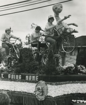
E.T. going home float by Pacific Vocational Institute students
https://search.heritageburnaby.ca/link/archivedescription58944
- Repository
- City of Burnaby Archives
- Date
- ca.1983
- Collection/Fonds
- Columbian Newspaper collection
- Description Level
- Item
- Physical Description
- 1 photograph : b&w ; 25.5 cm x 20.5 cm
- Scope and Content
- Photograph of a float constructed by Pacific Vocational Institute students. The float is based on the movie "E.T." and features some young adults on bicycles on the float.
- Repository
- City of Burnaby Archives
- Date
- ca.1983
- Collection/Fonds
- Columbian Newspaper collection
- Physical Description
- 1 photograph : b&w ; 25.5 cm x 20.5 cm
- Description Level
- Item
- Record No.
- 480-1390
- Access Restriction
- No restrictions
- Reproduction Restriction
- Reproduce for fair dealing purposes only
- Accession Number
- 2009-01
- Scope and Content
- Photograph of a float constructed by Pacific Vocational Institute students. The float is based on the movie "E.T." and features some young adults on bicycles on the float.
- Media Type
- Photograph
- Notes
- Title based on contents of photograph
- Note on recto: "E.T. going home by Pacific Vocational Institute students"
- Note on verso: "Burnaby Today / A-8 / Going home / 100%"
Images
![Forth Bridge, [1900-1930] thumbnail](/media/hpo/_Data/_Archives_Images/_Unrestricted/550/550-143.jpg?width=280)
Forth Bridge
https://search.heritageburnaby.ca/link/archivedescription82572
- Repository
- City of Burnaby Archives
- Date
- [1900-1930]
- Collection/Fonds
- Hill family and Vidal family fonds
- Description Level
- Item
- Physical Description
- 1 photograph : col. postcard ; 9 x 14 cm
- Scope and Content
- Photographic postcard shows Forth Bridge in Scotland.
- Repository
- City of Burnaby Archives
- Date
- [1900-1930]
- Collection/Fonds
- Hill family and Vidal family fonds
- Physical Description
- 1 photograph : col. postcard ; 9 x 14 cm
- Description Level
- Item
- Record No.
- 550-143
- Access Restriction
- No restrictions
- Reproduction Restriction
- No known restrictions
- Accession Number
- 2013-03
- Scope and Content
- Photographic postcard shows Forth Bridge in Scotland.
- Subjects
- Structures - Bridges
- Media Type
- Photograph
- Notes
- Title based on contents of photograph
- Postcard verso reads: "The Forth Bridge from South Queens Ferry. One of the greatest engineering glories of the age; was constructed by Sir William Arrol. Is about 1 1/2 miles in length, and its highest point is 450 feet from base. It took seven years to build (1883-1890) and cost 3 1/2 million pounds. It is on the main railway route of the L and N E Railway / New Color-crayon / Process from original drawing by Andrew Allan"
Images
![Forth Bridge, [1900-1930] thumbnail](/media/hpo/_Data/_Archives_Images/_Unrestricted/550/550-143.jpg)
![Interior of the Burnaby Substation, [September 1908] thumbnail](/media/hpo/_Data/_Archives_Images/_Unrestricted/251/293-003.jpg?width=280)
Interior of the Burnaby Substation
https://search.heritageburnaby.ca/link/archivedescription36542
- Repository
- City of Burnaby Archives
- Date
- [September 1908]
- Collection/Fonds
- Burnaby Historical Society fonds
- Description Level
- Item
- Physical Description
- 1 photograph : b&w postcard ; 7.5 x 13 cm
- Scope and Content
- Photographic postcard of the interior of the British Columbia Electric Railway Company's Burnaby Substation that was built in 1903 and put into operation to receive and distribute power from the B.C.E.R. Buntzen Lake power dam. The electric lines came across the inlet at Barnet, along the Barnet-Ha…
- Repository
- City of Burnaby Archives
- Date
- [September 1908]
- Collection/Fonds
- Burnaby Historical Society fonds
- Subseries
- John DeForest subseries
- Physical Description
- 1 photograph : b&w postcard ; 7.5 x 13 cm
- Description Level
- Item
- Record No.
- 293-003
- Access Restriction
- No restrictions
- Reproduction Restriction
- No known restrictions
- Accession Number
- BHS1992-30
- Scope and Content
- Photographic postcard of the interior of the British Columbia Electric Railway Company's Burnaby Substation that was built in 1903 and put into operation to receive and distribute power from the B.C.E.R. Buntzen Lake power dam. The electric lines came across the inlet at Barnet, along the Barnet-Hastings Road to Sperling Avenue (built for this project and called Pole Line Road) and then south to this site at the corner of Griffiths and the old Central Park interurban line (later this section was called the Highland Park line). This substation was constructed to convert the alternating current being delivered from the Buntzen power plant to direct current for the operation of the tram cars operating on the Central Park interurban route. The new brick substation replaced the wood fed steam powered 1891 Powerhouse that operated south of this site, across the tracks until its closure on May 31,1905. It was demolised in the late 1920s. This brick substation originally known as the Burnaby Substation, eventually became known as the Newell Substation. The original brick building was replaced by a new structure in 1930, which was demolished in the 1960s in favour of the open field substation that continues to operate on the same site today at 7260 Griffiths Avenue.
- Subjects
- Buildings - Industrial - Powerhouses
- Media Type
- Photograph
- Notes
- Title based on contents of photograph
- Geographic Access
- Griffiths Avenue
- Historic Neighbourhood
- Edmonds (Historic Neighbourhood)
- Planning Study Area
- Stride Avenue Area
Images
![Interior of the Burnaby Substation, [September 1908] thumbnail](/media/hpo/_Data/_Archives_Images/_Unrestricted/251/293-003.jpg)