Narrow Results By
Subject
- Buildings - Civic - City Halls 1
- Buildings - Industrial - Powerhouses 4
- Buildings - Residential - Houses 2
- Clothing - Costumes 1
- Geographic Features - Lanes 1
- Geographic Features - Roads 1
- Officials - Alderman and Councillors 1
- Persons - Children 1
- Transportation - Horses 1
- Transportation - Wagons 1

Stride Avenue Neighbourhood
https://search.heritageburnaby.ca/link/landmark845
- Repository
- Burnaby Heritage Planning
- Associated Dates
- 1955-2008
- Heritage Value
- The interurban link between New Westminster and Vancouver stimulated the early settlement of Stride Avenue. Infilling of the area took place in the early 1950s and the pace of development had slowed considerably by 1970. Duplexes became a popular feature in the decade between 1970 and 1980 and in the late 1980s, the neighbourhood was incorporated into the Edmonds Town Centre South plan.
- Historic Neighbourhood
- Edmonds (Historic Neighbourhood)
- Planning Study Area
- Stride Avenue Area
Images

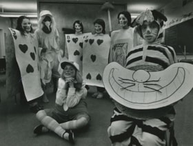
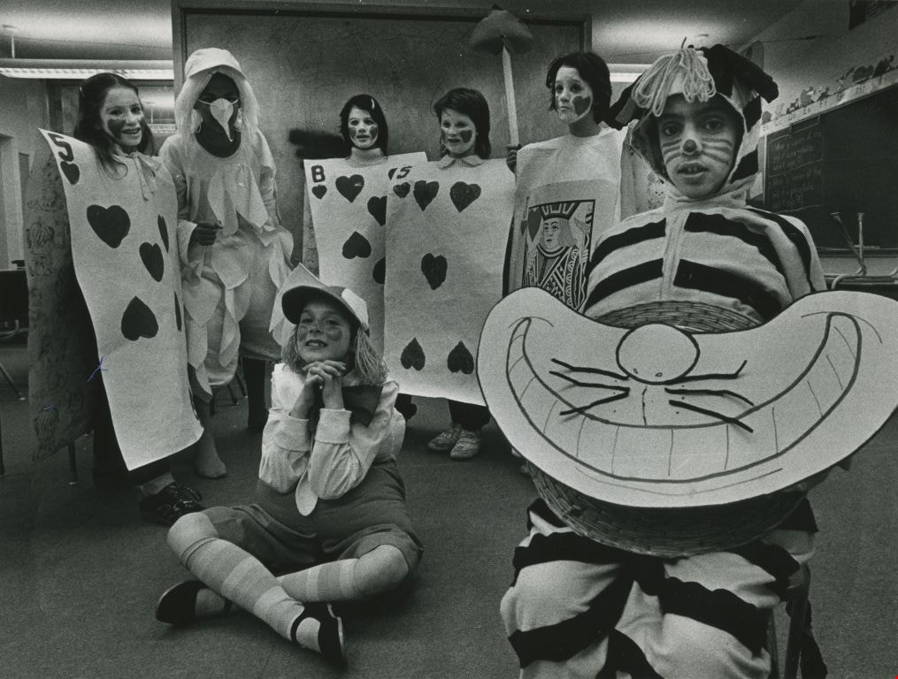
Alice in Wonderland Production - Stride Community School
https://search.heritageburnaby.ca/link/archivedescription59013
- Repository
- City of Burnaby Archives
- Date
- 1983
- Collection/Fonds
- Columbian Newspaper collection
- Description Level
- Item
- Physical Description
- 1 photograph : b&w ; 20.5 x 25.5 cm
- Scope and Content
- Photograph of students dressed in costume for a production of Alice in Wonderland at the Stride Community School.
- Repository
- City of Burnaby Archives
- Date
- 1983
- Collection/Fonds
- Columbian Newspaper collection
- Physical Description
- 1 photograph : b&w ; 20.5 x 25.5 cm
- Description Level
- Item
- Record No.
- 480-1422
- Access Restriction
- No restrictions
- Reproduction Restriction
- Reproduce for fair dealing purposes only
- Accession Number
- 2009-01
- Scope and Content
- Photograph of students dressed in costume for a production of Alice in Wonderland at the Stride Community School.
- Subjects
- Persons - Children
- Clothing - Costumes
- Names
- Stride Avenue School
- Media Type
- Photograph
- Photographer
- Battistoni, Peter
- Notes
- Title based on contents of photograph
- Note on recto reads: "Sherri Smart - Card / Isaac Melles - Dodo / Kristie Lamond - Tewedle Dum / Cheralee Hahn Michelle Lapre Jennifer Fox - Cards / Kulvinder Rai - Cheshire Cat"
- Photographer's stamp on verso
- Note on verso reads: "page A-8 / Burnaby / Today / PMT 100% / B-4 Saturday family page / reduce 80% / PMT twice / students stage Alice"
- Newspaper clipping attached to verso reads: "STUDENTS STAGE 'ALICE' ... Audiences attending the 'Alice in Wonderland' production staged this week by Stride Community School in Burnaby were delighted with the colorful portrayal of the familiar Lewis Carroll characters. Above, waiting their turn to go on stage are, from left at rear, Sherri Smart, Isaac Melles, Cheralee Hahn, Michelle Lapre and Jennifer Fox, and in foreground, Kristie Lamond Tweedle Dum and Kulvinder Rai (as the Cheshire cat)."
- Street Address
- 7014 Stride Avenue
- Historic Neighbourhood
- Edmonds (Historic Neighbourhood)
- Planning Study Area
- Stride Avenue Area
Images
![Burnaby's first Municipal Hall, [between 1899 and 1911] (date of original), copied 1995 thumbnail](/media/hpo/_Data/_Archives_Images/_Unrestricted/316/316-006.jpg?width=280)
Burnaby's first Municipal Hall
https://search.heritageburnaby.ca/link/archivedescription37100
- Repository
- City of Burnaby Archives
- Date
- [between 1899 and 1911] (date of original), copied 1995
- Collection/Fonds
- Burnaby Historical Society fonds
- Description Level
- Item
- Physical Description
- 1 photograph : b&w ; 10 x 15 cm print
- Scope and Content
- Photograph of council members and others sitting and standing on the steps of Burnaby's first Municipal Hall.
- Repository
- City of Burnaby Archives
- Date
- [between 1899 and 1911] (date of original), copied 1995
- Collection/Fonds
- Burnaby Historical Society fonds
- Subseries
- Byrne family subseries
- Physical Description
- 1 photograph : b&w ; 10 x 15 cm print
- Description Level
- Item
- Record No.
- 316-006
- Access Restriction
- No restrictions
- Reproduction Restriction
- No known restrictions
- Accession Number
- BHS1995-04
- Scope and Content
- Photograph of council members and others sitting and standing on the steps of Burnaby's first Municipal Hall.
- Names
- Burnaby City Hall
- Media Type
- Photograph
- Notes
- Title based on contents of photograph
- Geographic Access
- Kingsway
- Street Address
- 7252 Kingsway
- Historic Neighbourhood
- Edmonds (Historic Neighbourhood)
- Planning Study Area
- Stride Avenue Area
Images
![Burnaby's first Municipal Hall, [between 1899 and 1911] (date of original), copied 1995 thumbnail](/media/hpo/_Data/_Archives_Images/_Unrestricted/316/316-006.jpg)
![Burnaby Substation, [September 1907] thumbnail](/media/hpo/_Data/_Archives_Images/_Unrestricted/251/293-002.jpg?width=280)
Burnaby Substation
https://search.heritageburnaby.ca/link/archivedescription36541
- Repository
- City of Burnaby Archives
- Date
- [September 1907]
- Collection/Fonds
- Burnaby Historical Society fonds
- Description Level
- Item
- Physical Description
- 1 photograph : b&w postcard ; 7.5 x 13 cm
- Scope and Content
- Photographic postcard of the British Columbia Electric Railway Company's Burnaby Substation that was built in 1903 and put into operation to receive and distribute power from the B.C.E.R. Buntzen Lake power dam. The electric lines came across the inlet at Barnet, along the Barnet-Hastings Road to S…
- Repository
- City of Burnaby Archives
- Date
- [September 1907]
- Collection/Fonds
- Burnaby Historical Society fonds
- Subseries
- John DeForest subseries
- Physical Description
- 1 photograph : b&w postcard ; 7.5 x 13 cm
- Description Level
- Item
- Record No.
- 293-002
- Access Restriction
- No restrictions
- Reproduction Restriction
- No known restrictions
- Accession Number
- BHS1992-30
- Scope and Content
- Photographic postcard of the British Columbia Electric Railway Company's Burnaby Substation that was built in 1903 and put into operation to receive and distribute power from the B.C.E.R. Buntzen Lake power dam. The electric lines came across the inlet at Barnet, along the Barnet-Hastings Road to Sperling Avenue (built for this project and called Pole Line Road) and then south to this site at the corner of Griffiths and the old Central Park interurban line (later this section was called the Highland Park line). This substation was constructed to convert the alternating current being delivered from the Buntzen power plant to direct current for the operation of the tram cars operating on the Central Park interurban route. The new brick substation replaced the wood fed steam powered 1891 Powerhouse that operated south of this site, across the tracks until its closure on May 31,1905. It was demolised in the late 1920s. This brick substation originally known as the Burnaby Substation, eventually became known as the Newell Substation. The original brick building was replaced by a new structure in 1930, which was demolished in the 1960s in favour of the open field substation that continues to operate on the same site today at 7260 Griffiths Avenue.
- Subjects
- Buildings - Industrial - Powerhouses
- Media Type
- Photograph
- Notes
- Title based on contents of photograph
- Geographic Access
- Griffiths Avenue
- Historic Neighbourhood
- Edmonds (Historic Neighbourhood)
- Planning Study Area
- Stride Avenue Area
Images
![Burnaby Substation, [September 1907] thumbnail](/media/hpo/_Data/_Archives_Images/_Unrestricted/251/293-002.jpg)

D.C. Patterson house
https://search.heritageburnaby.ca/link/archivedescription34981
- Repository
- City of Burnaby Archives
- Date
- 1908 (date of original), copied 1986
- Collection/Fonds
- Burnaby Historical Society fonds
- Description Level
- Item
- Physical Description
- 1 photograph : b&w ; 8.8 x 12.5 cm print
- Scope and Content
- Photograph of the home of Dugald C. Patterson, Sr., and his family. The house was originally located at 7260 Edmonds Street (near Kingsway). It was relocated in 1955 to 7106 18th Avenue and is a city heritage site.
- Repository
- City of Burnaby Archives
- Date
- 1908 (date of original), copied 1986
- Collection/Fonds
- Burnaby Historical Society fonds
- Subseries
- Patterson family subseries
- Physical Description
- 1 photograph : b&w ; 8.8 x 12.5 cm print
- Description Level
- Item
- Record No.
- 171-002
- Access Restriction
- No restrictions
- Reproduction Restriction
- No known restrictions
- Accession Number
- BHS1986-20
- Scope and Content
- Photograph of the home of Dugald C. Patterson, Sr., and his family. The house was originally located at 7260 Edmonds Street (near Kingsway). It was relocated in 1955 to 7106 18th Avenue and is a city heritage site.
- Subjects
- Buildings - Residential - Houses
- Media Type
- Photograph
- Notes
- Title based on contents of photograph
- Geographic Access
- Edmonds Street
- 18th Avenue
- Street Address
- 7260 Edmonds Street
- 7106 18th Avenue
- Historic Neighbourhood
- Edmonds (Historic Neighbourhood)
- Planning Study Area
- Stride Avenue Area
Images

Edmonds St + 18th Ave (SW of 16th Street)
https://search.heritageburnaby.ca/link/archivedescription93727
- Repository
- City of Burnaby Archives
- Date
- March 1989
- Collection/Fonds
- Grover, Elliott & Co. Ltd. fonds
- Description Level
- File
- Physical Description
- 14 photographs : col. negatives ; 35 mm
- Scope and Content
- Photographs of the intersections at Edmonds Street and 18th Avenue and Edmonds Street and 16th Avenue and an unidentified residential lane.
- Repository
- City of Burnaby Archives
- Date
- March 1989
- Collection/Fonds
- Grover, Elliott & Co. Ltd. fonds
- Physical Description
- 14 photographs : col. negatives ; 35 mm
- Description Level
- File
- Record No.
- 622-015
- Access Restriction
- No restrictions
- Reproduction Restriction
- No restrictions
- Accession Number
- 2017-39
- Scope and Content
- Photographs of the intersections at Edmonds Street and 18th Avenue and Edmonds Street and 16th Avenue and an unidentified residential lane.
- Media Type
- Photograph
- Notes
- Transcribed title
- Title transcribed from original print envelope
- Photographs 622-015-001 : 622-015-002 depict Edmonds Street and 16th Avenue, facing south
- Photographs 622-015-003 : 622-015-004 depict the view southwest along Edmonds Street
- Photographs 622-015-006 : 622-015-008 depict the view southeast along 16th Street
- Photographs 622-015-009 : 622-015-011 depict the view southwest along 18th Avenue
- Locations were identified using notes on verso of accompanying prints
- Geographic Access
- 18th Avenue
- Edmonds Street
- 16th Avenue
- Historic Neighbourhood
- Edmonds (Historic Neighbourhood)
- Planning Study Area
- Stride Avenue Area
![Horse and wagon at D.C. Patterson's house, [1908] (date of original), copied 1986 thumbnail](/media/hpo/_Data/_Archives_Images/_Unrestricted/126/171-004.jpg?width=280)
Horse and wagon at D.C. Patterson's house
https://search.heritageburnaby.ca/link/archivedescription34983
- Repository
- City of Burnaby Archives
- Date
- [1908] (date of original), copied 1986
- Collection/Fonds
- Burnaby Historical Society fonds
- Description Level
- Item
- Physical Description
- 1 photograph : b&w ; 8.8 x 12.5 cm print
- Scope and Content
- Photograph of horse and wagon standing outside Dugald C. Patterson's Edmonds District home (not visible). The house was originally located at 7260 Edmonds Street (near Kingsway). It was relocated in 1955 to 7106 18th Avenue and is a city heritage site.
- Repository
- City of Burnaby Archives
- Date
- [1908] (date of original), copied 1986
- Collection/Fonds
- Burnaby Historical Society fonds
- Subseries
- Patterson family subseries
- Physical Description
- 1 photograph : b&w ; 8.8 x 12.5 cm print
- Description Level
- Item
- Record No.
- 171-004
- Access Restriction
- No restrictions
- Reproduction Restriction
- No known restrictions
- Accession Number
- BHS1986-20
- Scope and Content
- Photograph of horse and wagon standing outside Dugald C. Patterson's Edmonds District home (not visible). The house was originally located at 7260 Edmonds Street (near Kingsway). It was relocated in 1955 to 7106 18th Avenue and is a city heritage site.
- Media Type
- Photograph
- Notes
- Title based on contents of photograph
- Geographic Access
- Edmonds Street
- 18th Avenue
- Street Address
- 7260 Edmonds Street
- 7106 18th Avenue
- Historic Neighbourhood
- Edmonds (Historic Neighbourhood)
- Planning Study Area
- Stride Avenue Area
Images
![Horse and wagon at D.C. Patterson's house, [1908] (date of original), copied 1986 thumbnail](/media/hpo/_Data/_Archives_Images/_Unrestricted/126/171-004.jpg)
![Interior of the Burnaby Substation, [September 1908] thumbnail](/media/hpo/_Data/_Archives_Images/_Unrestricted/251/293-003.jpg?width=280)
Interior of the Burnaby Substation
https://search.heritageburnaby.ca/link/archivedescription36542
- Repository
- City of Burnaby Archives
- Date
- [September 1908]
- Collection/Fonds
- Burnaby Historical Society fonds
- Description Level
- Item
- Physical Description
- 1 photograph : b&w postcard ; 7.5 x 13 cm
- Scope and Content
- Photographic postcard of the interior of the British Columbia Electric Railway Company's Burnaby Substation that was built in 1903 and put into operation to receive and distribute power from the B.C.E.R. Buntzen Lake power dam. The electric lines came across the inlet at Barnet, along the Barnet-Ha…
- Repository
- City of Burnaby Archives
- Date
- [September 1908]
- Collection/Fonds
- Burnaby Historical Society fonds
- Subseries
- John DeForest subseries
- Physical Description
- 1 photograph : b&w postcard ; 7.5 x 13 cm
- Description Level
- Item
- Record No.
- 293-003
- Access Restriction
- No restrictions
- Reproduction Restriction
- No known restrictions
- Accession Number
- BHS1992-30
- Scope and Content
- Photographic postcard of the interior of the British Columbia Electric Railway Company's Burnaby Substation that was built in 1903 and put into operation to receive and distribute power from the B.C.E.R. Buntzen Lake power dam. The electric lines came across the inlet at Barnet, along the Barnet-Hastings Road to Sperling Avenue (built for this project and called Pole Line Road) and then south to this site at the corner of Griffiths and the old Central Park interurban line (later this section was called the Highland Park line). This substation was constructed to convert the alternating current being delivered from the Buntzen power plant to direct current for the operation of the tram cars operating on the Central Park interurban route. The new brick substation replaced the wood fed steam powered 1891 Powerhouse that operated south of this site, across the tracks until its closure on May 31,1905. It was demolised in the late 1920s. This brick substation originally known as the Burnaby Substation, eventually became known as the Newell Substation. The original brick building was replaced by a new structure in 1930, which was demolished in the 1960s in favour of the open field substation that continues to operate on the same site today at 7260 Griffiths Avenue.
- Subjects
- Buildings - Industrial - Powerhouses
- Media Type
- Photograph
- Notes
- Title based on contents of photograph
- Geographic Access
- Griffiths Avenue
- Historic Neighbourhood
- Edmonds (Historic Neighbourhood)
- Planning Study Area
- Stride Avenue Area
Images
![Interior of the Burnaby Substation, [September 1908] thumbnail](/media/hpo/_Data/_Archives_Images/_Unrestricted/251/293-003.jpg)
![Interior of the Burnaby Substation, [September 1908] thumbnail](/media/hpo/_Data/_Archives_Images/_Unrestricted/251/293-004.jpg?width=280)
Interior of the Burnaby Substation
https://search.heritageburnaby.ca/link/archivedescription36543
- Repository
- City of Burnaby Archives
- Date
- [September 1908]
- Collection/Fonds
- Burnaby Historical Society fonds
- Description Level
- Item
- Physical Description
- 1 photograph : b&w postcard ; 7.5 x 13 cm
- Scope and Content
- Photographic postcard of the interior of the British Columbia Electric Railway Company's Burnaby Substation that was built in 1903 and put into operation to receive and distribute power from the B.C.E.R. Buntzen Lake power dam. The electric lines came across the inlet at Barnet, along the Barnet-Ha…
- Repository
- City of Burnaby Archives
- Date
- [September 1908]
- Collection/Fonds
- Burnaby Historical Society fonds
- Subseries
- John DeForest subseries
- Physical Description
- 1 photograph : b&w postcard ; 7.5 x 13 cm
- Description Level
- Item
- Record No.
- 293-004
- Access Restriction
- No restrictions
- Reproduction Restriction
- No known restrictions
- Accession Number
- BHS1992-30
- Scope and Content
- Photographic postcard of the interior of the British Columbia Electric Railway Company's Burnaby Substation that was built in 1903 and put into operation to receive and distribute power from the B.C.E.R. Buntzen Lake power dam. The electric lines came across the inlet at Barnet, along the Barnet-Hastings Road to Sperling Avenue (built for this project and called Pole Line Road) and then south to this site at the corner of Griffiths and the old Central Park interurban line (later this section was called the Highland Park line). This substation was constructed to convert the alternating current being delivered from the Buntzen power plant to direct current for the operation of the tram cars operating on the Central Park interurban route. The new brick substation replaced the wood fed steam powered 1891 Powerhouse that operated south of this site, across the tracks until its closure on May 31,1905. It was demolised in the late 1920s. This brick substation originally known as the Burnaby Substation, eventually became known as the Newell Substation. The original brick building was replaced by a new structure in 1930, which was demolished in the 1960s in favour of the open field substation that continues to operate on the same site today at 7260 Griffiths Avenue.
- Subjects
- Buildings - Industrial - Powerhouses
- Media Type
- Photograph
- Notes
- Title based on contents of photograph
- Geographic Access
- Griffiths Avenue
- Historic Neighbourhood
- Edmonds (Historic Neighbourhood)
- Planning Study Area
- Stride Avenue Area
Images
![Interior of the Burnaby Substation, [September 1908] thumbnail](/media/hpo/_Data/_Archives_Images/_Unrestricted/251/293-004.jpg)

Interior of the Burnaby Substation
https://search.heritageburnaby.ca/link/archivedescription36544
- Repository
- City of Burnaby Archives
- Date
- 1907
- Collection/Fonds
- Burnaby Historical Society fonds
- Description Level
- Item
- Physical Description
- 1 photograph : sepia ; 12 x 17cm, mounted on board 22 x 27 cm
- Scope and Content
- Photograph of the interior of the British Columbia Electric Railway Company's Burnaby Substation that was built in 1903 and put into operation to receive and distribute power from the B.C.E.R. Buntzen Lake power dam. The electric lines came across the inlet at Barnet, along the Barnet-Hastings Road…
- Repository
- City of Burnaby Archives
- Date
- 1907
- Collection/Fonds
- Burnaby Historical Society fonds
- Subseries
- John DeForest subseries
- Physical Description
- 1 photograph : sepia ; 12 x 17cm, mounted on board 22 x 27 cm
- Description Level
- Item
- Record No.
- 293-005
- Access Restriction
- No restrictions
- Reproduction Restriction
- No known restrictions
- Accession Number
- BHS1992-30
- Scope and Content
- Photograph of the interior of the British Columbia Electric Railway Company's Burnaby Substation that was built in 1903 and put into operation to receive and distribute power from the B.C.E.R. Buntzen Lake power dam. The electric lines came across the inlet at Barnet, along the Barnet-Hastings Road to Sperling Avenue (built for this project and called Pole Line Road) and then south to this site at the corner of Griffiths and the old Central Park interurban line (later this section was called the Highland Park line). This substation was constructed to convert the alternating current being delivered from the Buntzen power plant to direct current for the operation of the tram cars operating on the Central Park interurban route. The new brick substation replaced the wood fed steam powered 1891 Powerhouse that operated south of this site, across the tracks until its closure on May 31,1905. It was demolised in the late 1920s. This brick substation originally known as the Burnaby Substation, eventually became known as the Newell Substation. The original brick building was replaced by a new structure in 1930, which was demolished in the 1960s in favour of the open field substation that continues to operate on the same site today at 7260 Griffiths Avenue.
- Subjects
- Buildings - Industrial - Powerhouses
- Media Type
- Photograph
- Notes
- Title based on contents of photograph
- Photographer's handwritten note (on the negative causing it to show) on recto of photograph reads: "Burnaby Substation/ B.C.E.R.C/O"
- Geographic Access
- Griffiths Avenue
- Historic Neighbourhood
- Edmonds (Historic Neighbourhood)
- Planning Study Area
- Stride Avenue Area
Images
