Narrow Results By
Creator
- Burnett, Geoffrey K. 1
- Burnett & McGugan, Engineers and Surveyors 7
- Draper, William Nelson 1
- Garden, Hermon and Burwell 2
- Garden, Hermon & Burwell 1
- Gauvreau, Narcisse B. 1
- Government of British Columbia - Department of Mines and Resources 1
- Government of Canada - Department of Mines - Geological Survey Branch 1
- Hill, Albert James 17
- Mahon, McFarland & Mahon 1
- Smith, H. Neville 3
- Stathern, John 1
Person / Organization
- All Saints Anglican Church 1
- British Columbia Electric Railway Company 1
- Broadview Presbyterian Church 1
- Brownlee, James Harrison 1
- Burnaby Advisory Planning Commission 1
- Burnaby Village Museum 3
- Dundonald United Church 1
- Grace, W. 1
- Great Northern Railway 1
- Hall, James Edward 1
- Hall, Joseph 1
- Harrison, John 1
![All Saints Church, [ca.1910] thumbnail](/media/hpo/_Data/_BVM_Cartographic_Material/2003/2003_0083_0046_001.jpg?width=280)
All Saints Church
https://search.heritageburnaby.ca/link/museumdescription11924
- Repository
- Burnaby Village Museum
- Date
- [ca.1910]
- Collection/Fonds
- Ronald G. Scobbie collection
- Description Level
- Item
- Physical Description
- 1 plan : black ink and watercol. on paper ; 30.45 x 30.5 cm
- Scope and Content
- Item consists of building insurance plan of "All Saints Church / Lot "A" BK 29 DL 98 GP1 N.W.D.". Watling Street is idenfied to the north of the church building and Royal Oak Avenue to the west.
- Repository
- Burnaby Village Museum
- Collection/Fonds
- Ronald G. Scobbie collection
- Description Level
- Item
- Physical Description
- 1 plan : black ink and watercol. on paper ; 30.45 x 30.5 cm
- Material Details
- Scale 1 inch = 20 feet
- Scope and Content
- Item consists of building insurance plan of "All Saints Church / Lot "A" BK 29 DL 98 GP1 N.W.D.". Watling Street is idenfied to the north of the church building and Royal Oak Avenue to the west.
- Subjects
- Buildings - Religious - Churches
- Accession Code
- BV003.83.46
- Access Restriction
- No restrictions
- Reproduction Restriction
- No known restrictions
- Date
- [ca.1910]
- Media Type
- Cartographic Material
- Scan Resolution
- 600
- Scan Date
- 15-Jan-2021
- Scale
- 100
- Notes
- Transcribed title
- Note in pencil on verso reads: ""All Saints Church / Lot "A" BK 29 DL 98 / Scale 1 inch = 20 feet"
- Note in balck in on verso reads: "3704"
Images
![All Saints Church, [ca.1910] thumbnail](/media/hpo/_Data/_BVM_Cartographic_Material/2003/2003_0083_0046_001.jpg)
![Anglican Church, [ca.1910] thumbnail](/media/hpo/_Data/_BVM_Cartographic_Material/2003/2003_0083_0043_001.jpg?width=280)
Anglican Church
https://search.heritageburnaby.ca/link/museumdescription11921
- Repository
- Burnaby Village Museum
- Date
- [ca.1910]
- Collection/Fonds
- Ronald G. Scobbie collection
- Description Level
- Item
- Physical Description
- 1 plan : black ink and watercol. on paper ; 30.45 x 30.5 cm
- Scope and Content
- Item consists of building insurance plan of "Anglican Church / Lot 2 BK 37 DL69, GP.1, N.W.D. (15th Ave. (Dominion) is identified to the north of Lots 1, 2 and 3).
- Repository
- Burnaby Village Museum
- Collection/Fonds
- Ronald G. Scobbie collection
- Description Level
- Item
- Physical Description
- 1 plan : black ink and watercol. on paper ; 30.45 x 30.5 cm
- Material Details
- Scale 1 inch = 20 feet
- Scope and Content
- Item consists of building insurance plan of "Anglican Church / Lot 2 BK 37 DL69, GP.1, N.W.D. (15th Ave. (Dominion) is identified to the north of Lots 1, 2 and 3).
- Subjects
- Buildings - Religious - Churches
- Accession Code
- BV003.83.43
- Access Restriction
- No restrictions
- Reproduction Restriction
- No known restrictions
- Date
- [ca.1910]
- Media Type
- Cartographic Material
- Scan Resolution
- 600
- Scan Date
- 15-Jan-2021
- Scale
- 100
- Notes
- Transcribed title
- Note in pencil on verso reads: "Anglican Church / Lot 2 Bk 37 DL69 / 1"=20' "
- Note in balck in on verso reads: "3704"
Images
![Anglican Church, [ca.1910] thumbnail](/media/hpo/_Data/_BVM_Cartographic_Material/2003/2003_0083_0043_001.jpg)
Board of Railway Commissioners
https://search.heritageburnaby.ca/link/archivedescription396
- Repository
- City of Burnaby Archives
- Date
- 1909-1912
- Collection/Fonds
- City Council and Office of the City Clerk fonds
- Description Level
- File
- Physical Description
- Textual record, cartographic material, and architectural drawings
- Scope and Content
- File contains correspondence and reports related to the activities of the Board of Railway Commissioners such as the movement of stations, culvert work, and the maintenance of crossings. File also includes white linen plan and blueprint plans (4) of culverts at Cariboo Road and V.W. and Y.Rlwy Jun…
- Repository
- City of Burnaby Archives
- Date
- 1909-1912
- Collection/Fonds
- City Council and Office of the City Clerk fonds
- Physical Description
- Textual record, cartographic material, and architectural drawings
- Description Level
- File
- Record No.
- 2096
- Accession Number
- 2001-02
- Scope and Content
- File contains correspondence and reports related to the activities of the Board of Railway Commissioners such as the movement of stations, culvert work, and the maintenance of crossings. File also includes white linen plan and blueprint plans (4) of culverts at Cariboo Road and V.W. and Y.Rlwy Junction, 1911.
- Notes
- Plans/maps are located in file and have not been moved to map case.
Boundary Plan - Location for Burnaby Council of the West Boundary of Lots 161 and 175 Group One
https://search.heritageburnaby.ca/link/archivedescription8042
- Repository
- City of Burnaby Archives
- Date
- [1909]
- Collection/Fonds
- City Council and Office of the City Clerk fonds
- Description Level
- Item
- Physical Description
- Cartographic material
- Scope and Content
- Item consists of one plan on waxed linen with colour ink noting the western boundary of District Lots 161 and 175.
- Repository
- City of Burnaby Archives
- Date
- [1909]
- Collection/Fonds
- City Council and Office of the City Clerk fonds
- Physical Description
- Cartographic material
- Description Level
- Item
- Record No.
- 10997
- Accession Number
- 2001-02
- Scope and Content
- Item consists of one plan on waxed linen with colour ink noting the western boundary of District Lots 161 and 175.
- Media Type
- Cartographic Material
- Notes
- Located in map case.
![Broadview Presbyterian Church, [ca.1910] thumbnail](/media/hpo/_Data/_BVM_Cartographic_Material/2003/2003_0083_0049_001.jpg?width=280)
Broadview Presbyterian Church
https://search.heritageburnaby.ca/link/museumdescription11927
- Repository
- Burnaby Village Museum
- Date
- [ca.1910]
- Collection/Fonds
- Ronald G. Scobbie collection
- Description Level
- Item
- Physical Description
- 1 plan : black ink and watercol. on paper ; 30.45 x 30.5 cm
- Scope and Content
- Item consists of building insurance plan of "Broadview Presbyterian Church / Lot 6, BK 31, DL 69 / GP1 N.W.D." . Fourteenth Avenue (Manor) is identified to the north and Douglas Ave. to the east.
- Repository
- Burnaby Village Museum
- Collection/Fonds
- Ronald G. Scobbie collection
- Description Level
- Item
- Physical Description
- 1 plan : black ink and watercol. on paper ; 30.45 x 30.5 cm
- Material Details
- Scale 1 inch = 20 feet
- Scope and Content
- Item consists of building insurance plan of "Broadview Presbyterian Church / Lot 6, BK 31, DL 69 / GP1 N.W.D." . Fourteenth Avenue (Manor) is identified to the north and Douglas Ave. to the east.
- Subjects
- Buildings - Religious - Churches
- Accession Code
- BV003.83.49
- Access Restriction
- No restrictions
- Reproduction Restriction
- No known restrictions
- Date
- [ca.1910]
- Media Type
- Cartographic Material
- Scan Resolution
- 600
- Scan Date
- 15-Jan-2021
- Scale
- 100
- Notes
- Transcribed title
- Note in pencil on verso reads: "Broadview Presbyterian Church / Lot 6, BK 31, DL 69 / 1" = 20' "
- Note in balck in on verso reads: "3704"
Images
![Broadview Presbyterian Church, [ca.1910] thumbnail](/media/hpo/_Data/_BVM_Cartographic_Material/2003/2003_0083_0049_001.jpg)
Burnaby Advisory Planning Commission records
https://search.heritageburnaby.ca/link/archivedescription82740
- Repository
- City of Burnaby Archives
- Date
- [1971-1996]
- Collection/Fonds
- Hazel Simnett collection
- Description Level
- File
- Physical Description
- 1 file of textual records ; 1 map ; 1 pin
- Scope and Content
- File consists of three letters, one envelope, a booklet, a map, a pin and a business card. The first letter found in the envelope from the Department of the Municipal Clerk is addressed to Hazel Simnett and approves her appointment to the Advisory Planning Commission in 1993. The second letter date…
- Repository
- City of Burnaby Archives
- Date
- [1971-1996]
- Collection/Fonds
- Hazel Simnett collection
- Physical Description
- 1 file of textual records ; 1 map ; 1 pin
- Description Level
- File
- Record No.
- MSS167-010
- Accession Number
- 2013-22
- Scope and Content
- File consists of three letters, one envelope, a booklet, a map, a pin and a business card. The first letter found in the envelope from the Department of the Municipal Clerk is addressed to Hazel Simnett and approves her appointment to the Advisory Planning Commission in 1993. The second letter dated March 17, 1995 is addressed to Hazel Simnett and approves her reappointment to the Advisory Planning Commission. The booklet is of the Burnaby Procedure Bylaw 1971 (bylaw number 6023 to regulate the proceedings of the Municipal Council of The Corporation of the District of Burnaby). The map is a street map of the Burnaby Planning & Building Department from 1992. The second letter is typewritten by Hazel Simnett to Mayor W. Copeland in 1996 regarding her resignation from the Advisory Planning Commission. The pin reads: "Burnaby Advisory Planning Commission". The business card is of Donald G. Stenson, Director Planning and Building of the Burnaby Planning and Building Department.
- Media Type
- Textual Record
- Cartographic Material
- Notes
- Title based on note accompanying file
- Simnett political papers series
![Burnaby Village Museum - Entrance, [1985] thumbnail](/media/hpo/_Data/_BVM_Architectural_Drawings/2019_0052_0088_001.jpg?width=280)
Burnaby Village Museum - Entrance
https://search.heritageburnaby.ca/link/museumdescription11752
- Repository
- Burnaby Village Museum
- Date
- [1985]
- Collection/Fonds
- Century Park Museum Association fonds
- Description Level
- Item
- Physical Description
- 1 drawing : b&w print hand col. (pencil crayons) on paper 46 x 58 cm ; mounted on foamcore board 71 x 58 cm
- Scope and Content
- Item consists of a presentation drawing for the proposed Burnaby Village Museum Expansion. Title at bottom of drawing "Entrance to the walkway / from the west".
- Repository
- Burnaby Village Museum
- Collection/Fonds
- Century Park Museum Association fonds
- Description Level
- Item
- Physical Description
- 1 drawing : b&w print hand col. (pencil crayons) on paper 46 x 58 cm ; mounted on foamcore board 71 x 58 cm
- Scope and Content
- Item consists of a presentation drawing for the proposed Burnaby Village Museum Expansion. Title at bottom of drawing "Entrance to the walkway / from the west".
- Names
- Burnaby Village Museum
- Accession Code
- BV019.52.88
- Access Restriction
- No restrictions
- Reproduction Restriction
- May be restricted by third party rights
- Date
- [1985]
- Media Type
- Graphic Material
- Notes
- Title based on contents of drawing
Images
![Burnaby Village Museum - Entrance, [1985] thumbnail](/media/hpo/_Data/_BVM_Architectural_Drawings/2019_0052_0088_001.jpg)
![Burnaby Village Museum - Inside the museum, [1985] thumbnail](/media/hpo/_Data/_BVM_Architectural_Drawings/2019_0052_0089_001.jpg?width=280)
Burnaby Village Museum - Inside the museum
https://search.heritageburnaby.ca/link/museumdescription11753
- Repository
- Burnaby Village Museum
- Date
- [1985]
- Collection/Fonds
- Century Park Museum Association fonds
- Description Level
- Item
- Physical Description
- 1 drawing : b&w print hand col. (pencil crayons) on paper 46 x 58 cm ; mounted on foamcore board 71 x 58 cm
- Scope and Content
- Item consists of a presentation drawing for the proposed Burnaby Village Museum Expansion. Title at bottom of drawing "Inside the museum".
- Repository
- Burnaby Village Museum
- Collection/Fonds
- Century Park Museum Association fonds
- Description Level
- Item
- Physical Description
- 1 drawing : b&w print hand col. (pencil crayons) on paper 46 x 58 cm ; mounted on foamcore board 71 x 58 cm
- Scope and Content
- Item consists of a presentation drawing for the proposed Burnaby Village Museum Expansion. Title at bottom of drawing "Inside the museum".
- Names
- Burnaby Village Museum
- Accession Code
- BV019.52.89
- Access Restriction
- No restrictions
- Reproduction Restriction
- May be restricted by third party rights
- Date
- [1985]
- Media Type
- Graphic Material
- Notes
- Title based on contents of drawing
Images
![Burnaby Village Museum - Inside the museum, [1985] thumbnail](/media/hpo/_Data/_BVM_Architectural_Drawings/2019_0052_0089_001.jpg)
![Burnaby Village Museum - Looking east towards the Adminstration complex, [1985] thumbnail](/media/hpo/_Data/_BVM_Architectural_Drawings/2019_0052_0090_001.jpg?width=280)
Burnaby Village Museum - Looking east towards the Adminstration complex
https://search.heritageburnaby.ca/link/museumdescription11754
- Repository
- Burnaby Village Museum
- Date
- [1985]
- Collection/Fonds
- Century Park Museum Association fonds
- Description Level
- Item
- Physical Description
- 1 drawing : b&w print hand col. (pencil crayons) on paper 46 x 58 cm ; mounted on foamcore board 71 x 58 cm
- Scope and Content
- Item consists of a presentation drawing for the proposed Burnaby Village Museum Expansion. Title at bottom of drawing "Looking east towards / the Adminstration / complex"
- Repository
- Burnaby Village Museum
- Collection/Fonds
- Century Park Museum Association fonds
- Description Level
- Item
- Physical Description
- 1 drawing : b&w print hand col. (pencil crayons) on paper 46 x 58 cm ; mounted on foamcore board 71 x 58 cm
- Scope and Content
- Item consists of a presentation drawing for the proposed Burnaby Village Museum Expansion. Title at bottom of drawing "Looking east towards / the Adminstration / complex"
- Names
- Burnaby Village Museum
- Accession Code
- BV019.52.90
- Access Restriction
- No restrictions
- Reproduction Restriction
- May be restricted by third party rights
- Date
- [1985]
- Media Type
- Graphic Material
- Notes
- Title based on contents of drawing
Images
![Burnaby Village Museum - Looking east towards the Adminstration complex, [1985] thumbnail](/media/hpo/_Data/_BVM_Architectural_Drawings/2019_0052_0090_001.jpg)
Cameron Road
https://search.heritageburnaby.ca/link/archivedescription324
- Repository
- City of Burnaby Archives
- Date
- [1904]
- Collection/Fonds
- City Council and Office of the City Clerk fonds
- Description Level
- File
- Physical Description
- Textual record and cartographic material
- Scope and Content
- File contains Cameron Road Plan.
- Repository
- City of Burnaby Archives
- Date
- [1904]
- Collection/Fonds
- City Council and Office of the City Clerk fonds
- Physical Description
- Textual record and cartographic material
- Description Level
- File
- Record No.
- 2017
- Accession Number
- 2001-02
- Scope and Content
- File contains Cameron Road Plan.
- Media Type
- Textual Record
- Cartographic Material
- Notes
- Plans/maps are located in file and have not been moved to map case.
Cancellation of plan - Block 2, DL 77
https://search.heritageburnaby.ca/link/archivedescription1142
- Repository
- City of Burnaby Archives
- Date
- [Between 1890 - 1918]
- Collection/Fonds
- City Council and Office of the City Clerk fonds
- Description Level
- File
- Physical Description
- Textual record and cartographic material
- Scope and Content
- Files consists of cancellation of plan Block 2, DL 77 and two accompanied blueprints 434 (April 8, 1890) and 238 (December 30, 1887)
- Repository
- City of Burnaby Archives
- Date
- [Between 1890 - 1918]
- Collection/Fonds
- City Council and Office of the City Clerk fonds
- Physical Description
- Textual record and cartographic material
- Description Level
- File
- Record No.
- 2933
- Accession Number
- 2001-02
- Scope and Content
- Files consists of cancellation of plan Block 2, DL 77 and two accompanied blueprints 434 (April 8, 1890) and 238 (December 30, 1887)
- Media Type
- Textual Record
- Cartographic Material
- Notes
- Plan of Lot 77, group 1 NWD : M9-B-1-4. Plan of subdivision of blocks 2-6, lot 77, group 1 NWD : M9-B-1-5
Crossing - B.C. Electric Railway Co.
https://search.heritageburnaby.ca/link/archivedescription657
- Repository
- City of Burnaby Archives
- Date
- 1909-1913
- Collection/Fonds
- City Council and Office of the City Clerk fonds
- Description Level
- File
- Physical Description
- Textual record and cartographic material
- Scope and Content
- File contains correspondence and reports pertaining to crossings on B.C. Electric Railway lines at Cariboo, Hastings, Boundary, Gilley, Jubilee, McKay, and Patterson.
- Repository
- City of Burnaby Archives
- Date
- 1909-1913
- Collection/Fonds
- City Council and Office of the City Clerk fonds
- Physical Description
- Textual record and cartographic material
- Description Level
- File
- Record No.
- 2382
- Accession Number
- 2001-02
- Scope and Content
- File contains correspondence and reports pertaining to crossings on B.C. Electric Railway lines at Cariboo, Hastings, Boundary, Gilley, Jubilee, McKay, and Patterson.
- Media Type
- Textual Record
- Cartographic Material
- Notes
- Vancouver and Lulu Island Railway Westminster and Eburne Byrne Road Crossing at Station 355 : M9-A-6-5; Trapp Road Crossing at Station 425 : M9-A-6-6
Ditches and water courses
https://search.heritageburnaby.ca/link/archivedescription662
- Repository
- City of Burnaby Archives
- Date
- 1908
- Collection/Fonds
- City Council and Office of the City Clerk fonds
- Description Level
- File
- Physical Description
- Textual record and cartographic material
- Scope and Content
- File contains reports, correspondence, declarations and appeals related to the construction of ditches and water courses as well as the application to construct ditches made by Ida I. Dow, William Buckoll, and O. Goodacre. File also includes white linen plan of "Proposed Ditch in lot 153, G1, NWD…
- Repository
- City of Burnaby Archives
- Date
- 1908
- Collection/Fonds
- City Council and Office of the City Clerk fonds
- Physical Description
- Textual record and cartographic material
- Description Level
- File
- Record No.
- 2387
- Accession Number
- 2001-02
- Scope and Content
- File contains reports, correspondence, declarations and appeals related to the construction of ditches and water courses as well as the application to construct ditches made by Ida I. Dow, William Buckoll, and O. Goodacre. File also includes white linen plan of "Proposed Ditch in lot 153, G1, NWD" located at M9-B-3-20.
- Media Type
- Textual Record
- Cartographic Material
- Notes
- A map of Proposed Ditch in Lot 153 : M9-B-3-20
Ditches and water courses (Sprott)
https://search.heritageburnaby.ca/link/archivedescription668
- Repository
- City of Burnaby Archives
- Date
- 1908
- Collection/Fonds
- City Council and Office of the City Clerk fonds
- Description Level
- File
- Physical Description
- Textual records, cartographic material and architectural material
- Scope and Content
- File contains correspondence, certificates signed by the District Engineer attesting to the fact that ditches were constructed according to the Ditches and Waterworks Act, as well as notices to residents that ditches were to be built along their property. File also includes 2 blueprint plans and 1…
- Repository
- City of Burnaby Archives
- Date
- 1908
- Collection/Fonds
- City Council and Office of the City Clerk fonds
- Physical Description
- Textual records, cartographic material and architectural material
- Description Level
- File
- Record No.
- 2393
- Accession Number
- 2001-02
- Scope and Content
- File contains correspondence, certificates signed by the District Engineer attesting to the fact that ditches were constructed according to the Ditches and Waterworks Act, as well as notices to residents that ditches were to be built along their property. File also includes 2 blueprint plans and 1 linen map of DL 79.
- Notes
- Plans/maps are located in file and have not been moved to map case.
Ditches - Woolard v. Burnaby
https://search.heritageburnaby.ca/link/archivedescription670
- Repository
- City of Burnaby Archives
- Date
- 1904-1907
- Collection/Fonds
- City Council and Office of the City Clerk fonds
- Description Level
- File
- Physical Description
- Textual record and cartographic material
- Scope and Content
- File contains correspondence and court transcripts from the trial John Woolard v. Municipality of Burnaby which arose from charges brought against Burnaby for interfering with a ditch built by Woolard. File includes a blueprint plan of "Profile on Water Surface in Holland Road Ditch and Woollard's…
- Repository
- City of Burnaby Archives
- Date
- 1904-1907
- Collection/Fonds
- City Council and Office of the City Clerk fonds
- Physical Description
- Textual record and cartographic material
- Description Level
- File
- Record No.
- 2395
- Accession Number
- 2001-02
- Scope and Content
- File contains correspondence and court transcripts from the trial John Woolard v. Municipality of Burnaby which arose from charges brought against Burnaby for interfering with a ditch built by Woolard. File includes a blueprint plan of "Profile on Water Surface in Holland Road Ditch and Woollard's Ditch " (1904) and a linen plan of Woollard's and Hooland Road ditches (lot 155a, group 1).
- Media Type
- Textual Record
- Cartographic Material
- Notes
- Plans/maps are located in file and have not been moved to map case.
![Dundonald United Church, [ca.1910] thumbnail](/media/hpo/_Data/_BVM_Cartographic_Material/2003/2003_0083_0052_001.jpg?width=280)
Dundonald United Church
https://search.heritageburnaby.ca/link/museumdescription11930
- Repository
- Burnaby Village Museum
- Date
- [ca.1910]
- Collection/Fonds
- Ronald G. Scobbie collection
- Description Level
- Item
- Physical Description
- 1 plan : black ink and watercol. on paper ; 30.45 x 30.5 cm
- Scope and Content
- Item consists of a building insurance plan of "Dundonald United Church / Lots 9, 10 BK 28 DL 159 GP 1 / N.W.D.". Clinton Street is identified to the north of Lots nine and ten.
- Repository
- Burnaby Village Museum
- Collection/Fonds
- Ronald G. Scobbie collection
- Description Level
- Item
- Physical Description
- 1 plan : black ink and watercol. on paper ; 30.45 x 30.5 cm
- Material Details
- Scale 1 inch = 20 feet
- Scope and Content
- Item consists of a building insurance plan of "Dundonald United Church / Lots 9, 10 BK 28 DL 159 GP 1 / N.W.D.". Clinton Street is identified to the north of Lots nine and ten.
- Subjects
- Buildings - Religious - Churches
- Names
- Dundonald United Church
- Accession Code
- BV003.83.52
- Access Restriction
- No restrictions
- Reproduction Restriction
- No known restrictions
- Date
- [ca.1910]
- Media Type
- Cartographic Material
- Scan Resolution
- 600
- Scan Date
- 15-Jan-2021
- Scale
- 100
- Notes
- Transcribed title
- Note in pencil on verso reads: "_ _Church / Lots 9 & 10 BK 28 DL 159 / 1" = 20' "
- Note in black ink on verso reads: "3704"
Images
![Dundonald United Church, [ca.1910] thumbnail](/media/hpo/_Data/_BVM_Cartographic_Material/2003/2003_0083_0052_001.jpg)
Gunn Road diversion (Banfield, J.J.)
https://search.heritageburnaby.ca/link/archivedescription319
- Repository
- City of Burnaby Archives
- Date
- 1905-1911
- Collection/Fonds
- City Council and Office of the City Clerk fonds
- Description Level
- File
- Physical Description
- Textual record and cartographic material
- Scope and Content
- File contains records, including blueprint, related to the proposed diversion of Gunn Road.
- Repository
- City of Burnaby Archives
- Date
- 1905-1911
- Collection/Fonds
- City Council and Office of the City Clerk fonds
- Physical Description
- Textual record and cartographic material
- Description Level
- File
- Record No.
- 2010
- Accession Number
- 2001-02
- Scope and Content
- File contains records, including blueprint, related to the proposed diversion of Gunn Road.
- Media Type
- Textual Record
- Cartographic Material
- Notes
- White linen plan : Diversion of Gunn Road Lots 10 and 4 Group One" : M9-A-3-17.
Hastings Road
https://search.heritageburnaby.ca/link/archivedescription458
- Repository
- City of Burnaby Archives
- Date
- 1908-1909
- Collection/Fonds
- City Council and Office of the City Clerk fonds
- Description Level
- File
- Physical Description
- Textual record and cartographic material
- Scope and Content
- File consists of correspondence and reports arising from a survey of Hastings Road and two maps associated with the correspondence. One map is of Hastings Road through Westminster District and the the other is a tracing of Douglas Road from original notes of the Royal Engineers.
- Repository
- City of Burnaby Archives
- Date
- 1908-1909
- Collection/Fonds
- City Council and Office of the City Clerk fonds
- Physical Description
- Textual record and cartographic material
- Description Level
- File
- Record No.
- 2163
- Accession Number
- 2001-02
- Scope and Content
- File consists of correspondence and reports arising from a survey of Hastings Road and two maps associated with the correspondence. One map is of Hastings Road through Westminster District and the the other is a tracing of Douglas Road from original notes of the Royal Engineers.
- Media Type
- Textual Record
- Cartographic Material
- Notes
- A map of Hastings Road through N. West (1909) : M9-B-1-1; "Tracing of original notes from Royal Engineers of Douglas Road" : M9-B-1-2
Hastings Road diversion
https://search.heritageburnaby.ca/link/archivedescription322
- Repository
- City of Burnaby Archives
- Date
- [1906]
- Collection/Fonds
- City Council and Office of the City Clerk fonds
- Description Level
- File
- Physical Description
- Textual record and cartographic material
- Scope and Content
- File contains record of surveys done for Hastings Road diversion. White linen plans in map case.
- Repository
- City of Burnaby Archives
- Date
- [1906]
- Collection/Fonds
- City Council and Office of the City Clerk fonds
- Physical Description
- Textual record and cartographic material
- Description Level
- File
- Record No.
- 2015
- Accession Number
- 2001-02
- Scope and Content
- File contains record of surveys done for Hastings Road diversion. White linen plans in map case.
- Media Type
- Textual Record
- Cartographic Material
- Notes
- Survey of Hastings Road from Hastings Townsite to Still Creek : M9-A-3-2; M9-A-3-7
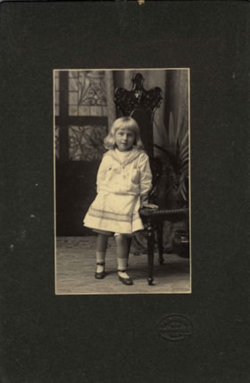
Kitty Hill
https://search.heritageburnaby.ca/link/archivedescription66567
- Repository
- City of Burnaby Archives
- Date
- 1904
- Collection/Fonds
- Peers Family and Hill Family fonds
- Description Level
- Item
- Physical Description
- 1 photograph : b&w + 1 watercolour painting
- Scope and Content
- Photograph is a portrait of Kitty Hill, posing next to a high-back chair. Accompanying the photograph is a watercolour painting that was based on this photograph, done on a linen backing.
- Repository
- City of Burnaby Archives
- Date
- 1904
- Collection/Fonds
- Peers Family and Hill Family fonds
- Physical Description
- 1 photograph : b&w + 1 watercolour painting
- Description Level
- Item
- Record No.
- 477-1181
- Access Restriction
- No restrictions
- Reproduction Restriction
- No known restrictions
- Accession Number
- 2007-12
- Scope and Content
- Photograph is a portrait of Kitty Hill, posing next to a high-back chair. Accompanying the photograph is a watercolour painting that was based on this photograph, done on a linen backing.
- Media Type
- Photograph
- Graphic Material
- Notes
- Title based on contents of photograph
Images
