Narrow Results By
Subject
- Accidents 1
- Animals - Birds 1
- Animals - Cats 1
- Animals - Dogs 1
- Buildings 2
- Buildings - Civic - City Halls 1
- Buildings - Commercial 6
- Buildings - Commercial - Automobile Dealerships 2
- Buildings - Commercial - Banks 6
- Buildings - Commercial - Cinemas 1
- Buildings - Commercial - Drugstores 3
- Buildings - Commercial - General Stores 2

Metrotown
https://search.heritageburnaby.ca/link/landmark817
- Repository
- Burnaby Heritage Planning
- Geographic Access
- Kingsway
- Associated Dates
- 1986
- Heritage Value
- Although the idea for Metrotown was first expressed in the 1970s, the building itself opened in 1986 and was soon served by the Expo Line of the new SkyTrain system. In the ensuing twenty years, the complex developed into three distinct but adjoining malls - Metropolis at Metrotown, Metrotown Centre, and Station Square. Today, Metrotown serves as the city’s commercial and retail anchor. The mall also includes two large office towers, which by 2001 were home to the head offices for Shaw Cable and TransLink.
- Historic Neighbourhood
- Central Park (Historic Neighbourhood)
- Planning Study Area
- Maywood Area
- Street Address
- 4700 Kingsway
- Street View URL
- Google Maps Street View
Images


St. John the Divine Anglican Church
https://search.heritageburnaby.ca/link/landmark514
- Repository
- Burnaby Heritage Planning
- Description
- St. John the Divine Anglican Church is a landmark wood-frame Gothic Revival church, with Gothic windows and spire. It is located on Kingsway, one of Burnaby’s main commercial thoroughfares, near the SkyTrain transit line and across the street from Central Park.
- Associated Dates
- 1905
- Formal Recognition
- Community Heritage Register
- Street View URL
- Google Maps Street View
- Repository
- Burnaby Heritage Planning
- Geographic Access
- Kingsway
- Associated Dates
- 1905
- Formal Recognition
- Community Heritage Register
- Enactment Type
- Council Resolution
- Enactment Date
- 09/06/2003
- Description
- St. John the Divine Anglican Church is a landmark wood-frame Gothic Revival church, with Gothic windows and spire. It is located on Kingsway, one of Burnaby’s main commercial thoroughfares, near the SkyTrain transit line and across the street from Central Park.
- Heritage Value
- St. John the Divine Anglican Church is valued as a symbol of the traditions of early Burnaby pioneers and as the oldest surviving church building in the city. Established in 1899, St. John was the first church in the community and was located at a prominent intersection of the old Vancouver-Westminster Road (now Kingsway) and the British Columbia Electric Railway’s interurban station at Central Park. This prominent intersection of the road and rail developed as the town centre of the Central Park district. The first St. John church was destroyed by fire, and was rebuilt at the same location in 1904-05. This church is additionally significant for its association with prominent local architect Joseph Henry Bowman (1864-1943) who emigrated from England in 1888. Bowman was a member of the parish, and designed both the first church and its subsequent replacement. Bowman’s prolific career embraced many stylistic changes and technological advances, and this church is a surviving example of one of his rare religious commissions. The design of the new church's nave and vestry was based on the Gothic Revival style of Christ Church Anglican in Surrey, B.C., which had been the former church of St. John’s incumbent Rev. William Bell. Evolving over time as the congregation grew, the church received a number of early additions, and in 1953 was substantially renovated and enlarged through a new design by Vancouver architect Ross Lort. The original church nave was separated from the tower and turned to allow for a large addition. The congregation relocated to a new church in 1998, and at that time removed the church's memorial windows, leaving behind a number of the original art glass windows installed in the 1920s. The church building was renovated in 2004-05, and surviving original elements were retained and restored, including of the original church tower and interior chancel ceiling. A valued feature of the building is the original cast iron church bell that remains in the tower. It was purchased by the children of the congregation in 1912, and in 1924 was rededicated on Armistice Day as a memorial to Burnaby resident Lt. James Donald McRae Reid, who died in the First World War.
- Defining Elements
- Key elements that define the heritage character of St. John the Divine Anglican Church include its: - location on the north side of Kingsway, opposite Central Park - ecclesiastical form, scale and massing as expressed by the offset tower and tall, gabled roof - tower with its original horizontal wooden drop siding, bellcast square roof with octagonal drum above and bellcast octagonal spire - cedar shingle roof cladding - metal cross at peak of spire - Gothic Revival details such as: Gothic lancet windows with leaded stained glass panels; Gothic entrance door at the base of the tower; pointed-arch louvers in the tower; and exterior gable end scissor-trusses - interior features such as wooden scissor-trusses with diagonal fir tongue and groove panelling on the ceiling above, fir tongue-and-groove panelling on the wall of the nave, and original cedar and fir pews and altar rails - cast iron bell in tower
- Historic Neighbourhood
- Central Park (Historic Neighbourhood)
- Planning Study Area
- Garden Village Area
- Architect
- Joesph Henry Bowman
- Function
- Primary Historic--Place of Worship
- Primary Current--Place of Worship
- Community
- Burnaby
- Cadastral Identifier
- 003-398-871
- Boundaries
- St. John the Divine Anglican Church is comprised of a single institutional lot located at 3891 Kingway, Burnaby.
- Area
- 3486.66
- Contributing Resource
- Building
- Ownership
- Private
- Street Address
- 3891 Kingsway
- Street View URL
- Google Maps Street View
Images


![1st Div 1907 West Burnaby School, [1907] thumbnail](/media/hpo/_Data/_BVM_Images/2012/2012_0020_0002_001.jpg?width=280)
1st Div 1907 West Burnaby School
https://search.heritageburnaby.ca/link/museumdescription2939
- Repository
- Burnaby Village Museum
- Date
- [1907]
- Collection/Fonds
- Burnaby Village Museum Photograph collection
- Description Level
- Item
- Physical Description
- 1 photograph : b&w ; 13 x 8.2 cm
- Scope and Content
- Photograph of the First Division class for 1907 at West Burnaby School (later renamed Kingsway West School). There are two rows of students standing and one row of seated students. there is a male teacher standing on the left side of the group just beside a bicycle that is leaning against the build…
- Repository
- Burnaby Village Museum
- Collection/Fonds
- Burnaby Village Museum Photograph collection
- Description Level
- Item
- Physical Description
- 1 photograph : b&w ; 13 x 8.2 cm
- Material Details
- Handwritten in the photograph is "1st Div 1907 / West Burnaby School". The reverse side of the photograph is printed in a postcard format.
- Scope and Content
- Photograph of the First Division class for 1907 at West Burnaby School (later renamed Kingsway West School). There are two rows of students standing and one row of seated students. there is a male teacher standing on the left side of the group just beside a bicycle that is leaning against the building.
- Subjects
- Occupations - Teachers
- Persons - Students
- Names
- Kingsway West School
- Geographic Access
- Kingsway
- Street Address
- 4800 Kingsway
- Accession Code
- BV012.20.2
- Access Restriction
- No restrictions
- Reproduction Restriction
- No known restrictions
- Date
- [1907]
- Media Type
- Photograph
- Historic Neighbourhood
- Central Park (Historic Neighbourhood)
- Planning Study Area
- Maywood Area
- Scan Resolution
- 600
- Scan Date
- 13-Mar-2018
- Notes
- Title based on contents of photograph
Images
![1st Div 1907 West Burnaby School, [1907] thumbnail](/media/hpo/_Data/_BVM_Images/2012/2012_0020_0002_001.jpg)
4021 Kingsway, Burnaby
https://search.heritageburnaby.ca/link/archivedescription93882
- Repository
- City of Burnaby Archives
- Date
- February 8, 1993
- Collection/Fonds
- Grover, Elliott & Co. Ltd. fonds
- Description Level
- File
- Physical Description
- 22 photographs : col. negatives ; 35 mm
- Scope and Content
- Photographs of an undeveloped property located at 4021 Kingsway and the intersection at Kingsway and Inman Avenue.
- Repository
- City of Burnaby Archives
- Date
- February 8, 1993
- Collection/Fonds
- Grover, Elliott & Co. Ltd. fonds
- Physical Description
- 22 photographs : col. negatives ; 35 mm
- Description Level
- File
- Record No.
- 622-065
- Access Restriction
- No restrictions
- Reproduction Restriction
- No restrictions
- Accession Number
- 2017-39
- Scope and Content
- Photographs of an undeveloped property located at 4021 Kingsway and the intersection at Kingsway and Inman Avenue.
- Subjects
- Geographic Features - Roads
- Buildings
- Media Type
- Photograph
- Notes
- Transcribed title
- Title transcribed from envelope photographs were originally housed in
- File no. 93-058-B
- Geographic Access
- Kingsway
- Inman Avenue
- Street Address
- 4021 Kingsway
- Historic Neighbourhood
- Central Park (Historic Neighbourhood)
- Planning Study Area
- Garden Village Area
4260 Edmonds St.
https://search.heritageburnaby.ca/link/archivedescription94351
- Repository
- City of Burnaby Archives
- Date
- October 1995
- Collection/Fonds
- Grover, Elliott & Co. Ltd. fonds
- Description Level
- File
- Physical Description
- 26 photographs : col. negatives ; 35 mm
- Scope and Content
- Photographs of the exterior of Lumberland, located at 4260 Edmonds Street (an address that no longer exists) and the surrounding area at Edmonds Street and Kingsway.
- Repository
- City of Burnaby Archives
- Date
- October 1995
- Collection/Fonds
- Grover, Elliott & Co. Ltd. fonds
- Physical Description
- 26 photographs : col. negatives ; 35 mm
- Description Level
- File
- Record No.
- 622-136
- Access Restriction
- No restrictions
- Reproduction Restriction
- No restrictions
- Accession Number
- 2017-39
- Scope and Content
- Photographs of the exterior of Lumberland, located at 4260 Edmonds Street (an address that no longer exists) and the surrounding area at Edmonds Street and Kingsway.
- Subjects
- Buildings - Commercial
- Names
- Lumberland
- Media Type
- Photograph
- Photographer
- Young, Richard
- Notes
- Transcribed title
- Title transcribed from envelope photographs were originally housed in
- File no. 95-358-B
- Sticky note adhered to 622-135-1 print reads: "3) View north east from Edmonds St."
- Sticky note adhered to 622-135-2 print reads: "4) View east along Kingsway"
- Sticky note adhered to 622-135-5 print reads: "8) View south along the east lane"
- Sticky note adhered to 622-135-8 print reads: "2) View south west from Kingsway"
- Sticky note adhered to 622-135-11 print reads: "5) View west along Kingsway"
- Sticky note adhered to 622-135-14 print reads: "1) View south from Kingsway"
- Sticky note adhered to 622-135-18 print reads: "6) View south along Edmonds St."
- Sticky note adhered to 622-135-21 print reads: "7) View north along Edmonds St."
- Geographic Access
- Edmonds Street
- Kingsway
7026 Kingsway
https://search.heritageburnaby.ca/link/archivedescription94304
- Repository
- City of Burnaby Archives
- Date
- January 1994
- Collection/Fonds
- Grover, Elliott & Co. Ltd. fonds
- Description Level
- File
- Physical Description
- 19 photographs : col. negatives ; 35 mm
- Scope and Content
- Photographs of commercial and undeveloped properties located in the 7100 block of Kingsway, including Middlegate Honda, with mid-rise towers visible in the background.
- Repository
- City of Burnaby Archives
- Date
- January 1994
- Collection/Fonds
- Grover, Elliott & Co. Ltd. fonds
- Physical Description
- 19 photographs : col. negatives ; 35 mm
- Description Level
- File
- Record No.
- 622-089
- Access Restriction
- No restrictions
- Reproduction Restriction
- No restrictions
- Accession Number
- 2017-39
- Scope and Content
- Photographs of commercial and undeveloped properties located in the 7100 block of Kingsway, including Middlegate Honda, with mid-rise towers visible in the background.
- Media Type
- Photograph
- Notes
- Transcribed title
- Title transcribed from envelope photographs were originally housed in
- File no. 94-028-B
- Photographer identified as "L.D."
- Geographic Access
- Kingsway
- Historic Neighbourhood
- Edmonds (Historic Neighbourhood)
- Planning Study Area
- Stride Avenue Area
7026 Kingsway, Burnaby
https://search.heritageburnaby.ca/link/archivedescription93819
- Repository
- City of Burnaby Archives
- Date
- January 1993
- Collection/Fonds
- Grover, Elliott & Co. Ltd. fonds
- Description Level
- File
- Physical Description
- 32 photographs : col. negatives ; 35 mm
- Scope and Content
- Photographs of an undeveloped property located at 7026 Kingsway - an address that no longer exists.
- Repository
- City of Burnaby Archives
- Date
- January 1993
- Collection/Fonds
- Grover, Elliott & Co. Ltd. fonds
- Physical Description
- 32 photographs : col. negatives ; 35 mm
- Description Level
- File
- Record No.
- 622-062
- Access Restriction
- No restrictions
- Reproduction Restriction
- No restrictions
- Accession Number
- 2017-39
- Scope and Content
- Photographs of an undeveloped property located at 7026 Kingsway - an address that no longer exists.
- Subjects
- Geographic Features - Roads
- Media Type
- Photograph
- Notes
- Transcribed title
- Title transcribed from envelope photographs were originally housed in
- File no. 93-013-R
- Sticky note adhered to 622-062-4 print reads: "1 / 7026 Kingsway Burnaby, B.C."
- Sticky note adhere to 622-062-8 print reads: "3 / View west along Kingsway"
- Sticky note adhered to 622-062-12 print reads: "5 / View northwest across the site from Beresford Street"
- Sticky note adhered to 622-062-16 print reads: "4 . View [illegible] along to Beresford Ave. right of way at the southeast corner of the [illegible] site"
- Sticky note adhered to 622-062-20 print reads: "6 / View east along Beresford Street at Greenford Avenue"
- Sticky note adhered to 622-062-24 print reads: "7 / View north along Greenford Avenue"
- Sticky note adhered to 622-062-28 print reads: "8 / View northeast across the site from Grenford Avenue"
- Sticky note adhered to 622-062-32 print reads: "2 / View east along Kingsway past subject site"
- Photographer identified as "D.E."
- Geographic Access
- Kingsway
- Historic Neighbourhood
- Edmonds (Historic Neighbourhood)
- Planning Study Area
- Stride Avenue Area
7641-51 Kingsway Ave
https://search.heritageburnaby.ca/link/archivedescription94346
- Repository
- City of Burnaby Archives
- Date
- August 1995
- Collection/Fonds
- Grover, Elliott & Co. Ltd. fonds
- Description Level
- File
- Physical Description
- 25 photographs : col. negatives ; 35 mm
- Scope and Content
- Photographs of a two-storey commercial building located on the 7600 block of Kingsway and the Burnaby Hotel on the opposite side of the street.
- Repository
- City of Burnaby Archives
- Date
- August 1995
- Collection/Fonds
- Grover, Elliott & Co. Ltd. fonds
- Physical Description
- 25 photographs : col. negatives ; 35 mm
- Description Level
- File
- Record No.
- 622-131
- Access Restriction
- No restrictions
- Reproduction Restriction
- No restrictions
- Accession Number
- 2017-39
- Scope and Content
- Photographs of a two-storey commercial building located on the 7600 block of Kingsway and the Burnaby Hotel on the opposite side of the street.
- Media Type
- Photograph
- Notes
- Transcribed title
- Title transcribed from envelope photographs were originally housed in
- File no. 95-286-B
- Photographer identified as "L.D."
- Geographic Access
- Kingsway
- Historic Neighbourhood
- Edmonds (Historic Neighbourhood)
- Planning Study Area
- Stride Avenue Area
![A. MacKenzie and Company Jubilee Store, [1907 or 1908] thumbnail](/media/hpo/_Data/_BVM_Images/1985/1985_0024_0001_001.jpg?width=280)
A. MacKenzie and Company Jubilee Store
https://search.heritageburnaby.ca/link/museumdescription159
- Repository
- Burnaby Village Museum
- Date
- [1907 or 1908]
- Collection/Fonds
- Burnaby Village Museum Photograph collection
- Description Level
- Item
- Physical Description
- 1 photograph : b&w ; 9.8 x 14.0 cm, mounted on cardboard 13.2 x 18.8 cm
- Scope and Content
- Photograph of the exterior of a store on the ground floor of a two-storey building, with a sign painted on the front face of the second floor. It reads, "A. MacKenzie & Co / Jubilee Store." There are two men in suits standing out in front of the display windows that show stacks of boxes and cans.…
- Repository
- Burnaby Village Museum
- Collection/Fonds
- Burnaby Village Museum Photograph collection
- Description Level
- Item
- Physical Description
- 1 photograph : b&w ; 9.8 x 14.0 cm, mounted on cardboard 13.2 x 18.8 cm
- Scope and Content
- Photograph of the exterior of a store on the ground floor of a two-storey building, with a sign painted on the front face of the second floor. It reads, "A. MacKenzie & Co / Jubilee Store." There are two men in suits standing out in front of the display windows that show stacks of boxes and cans. The lot around the building looks vacant, but fenced. There is a wagon drawn by a team of two horses parked or travelling towards the store on the right side of the photograph. The store was owned by Alexander MacKenzie, (1870-1949) who arrived in Vancouver in 1907. There is a discrepancy in the date of the photograph; the accession register dates the photograph 1909 while the donation form signed by the donor dates all the photographs in the accession as 1907 or 1908. Annotations on the bottom front of the card mount read: "Ralph Libby" and "Vancouver B.C." This store later became the Matheson and Sons Market.
- Geographic Access
- Kingsway
- Nelson Avenue
- Accession Code
- BV985.24.1
- Access Restriction
- No restrictions
- Reproduction Restriction
- No known restrictions
- Date
- [1907 or 1908]
- Media Type
- Photograph
- Historic Neighbourhood
- Central Park (Historic Neighbourhood)
- Planning Study Area
- Marlborough Area
- Scan Resolution
- 600
- Scan Date
- 2023-12-19
- Photographer
- Libby, Ralph
- Notes
- Title based on contents of photograph
Images
![A. MacKenzie and Company Jubilee Store, [1907 or 1908] thumbnail](/media/hpo/_Data/_BVM_Images/1985/1985_0024_0001_001.jpg)

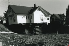
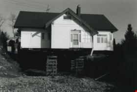
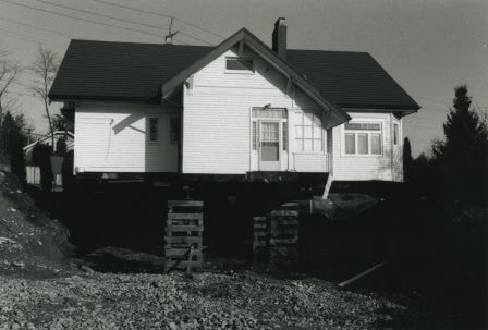
Back and side of the Britton house
https://search.heritageburnaby.ca/link/archivedescription36581
- Repository
- City of Burnaby Archives
- Date
- November 1992
- Collection/Fonds
- Burnaby Historical Society fonds
- Description Level
- Item
- Physical Description
- 1 photograph : b&w ; 10 x 15 cm print
- Scope and Content
- Photograph of back and side of the Britton house taken from ground level during the Britton house moving project, while the house was up on stilts.
- Repository
- City of Burnaby Archives
- Date
- November 1992
- Collection/Fonds
- Burnaby Historical Society fonds
- Subseries
- Britton family subseries
- Physical Description
- 1 photograph : b&w ; 10 x 15 cm print
- Description Level
- Item
- Record No.
- 303-003
- Access Restriction
- No restrictions
- Reproduction Restriction
- Reproduce for fair dealing purposes only
- Accession Number
- BHS1992-44
- Scope and Content
- Photograph of back and side of the Britton house taken from ground level during the Britton house moving project, while the house was up on stilts.
- Subjects
- Buildings - Residential - Houses
- Media Type
- Photograph
- Notes
- Title based on contents of photograph
- 1 b&w negative accompanying
- Geographic Access
- Kingsway
- Street Address
- 7505 Kingsway
- Historic Neighbourhood
- Edmonds (Historic Neighbourhood)
- Planning Study Area
- Stride Avenue Area
Images
Back and side of the Britton house
https://search.heritageburnaby.ca/link/archivedescription36589
- Repository
- City of Burnaby Archives
- Date
- November 1992
- Collection/Fonds
- Burnaby Historical Society fonds
- Description Level
- Item
- Physical Description
- 1 photograph : b&w ; 10 x 15 cm print
- Scope and Content
- Photograph of back and side of the Britton house taken from ground level during the Britton house moving project, while the house was up on stilts.
- Repository
- City of Burnaby Archives
- Date
- November 1992
- Collection/Fonds
- Burnaby Historical Society fonds
- Subseries
- Britton family subseries
- Physical Description
- 1 photograph : b&w ; 10 x 15 cm print
- Description Level
- Item
- Record No.
- 303-011
- Access Restriction
- No restrictions
- Reproduction Restriction
- Reproduce for fair dealing purposes only
- Accession Number
- BHS1992-44
- Scope and Content
- Photograph of back and side of the Britton house taken from ground level during the Britton house moving project, while the house was up on stilts.
- Subjects
- Buildings - Residential - Houses
- Media Type
- Photograph
- Notes
- Title based on contents of photograph
- 1 b&w negative accompanying
- Geographic Access
- Kingsway
- Street Address
- 7505 Kingsway
- Historic Neighbourhood
- Edmonds (Historic Neighbourhood)
- Planning Study Area
- Stride Avenue Area
Images
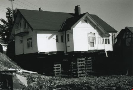
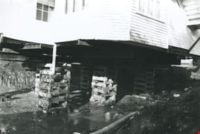
Back of the Britton house
https://search.heritageburnaby.ca/link/archivedescription36585
- Repository
- City of Burnaby Archives
- Date
- November 1992
- Collection/Fonds
- Burnaby Historical Society fonds
- Description Level
- Item
- Physical Description
- 1 photograph : b&w ; 10 x 15 cm print
- Scope and Content
- Photograph of the back of the Britton house up on stilts and its surrounding yard during the Britton house moving project.
- Repository
- City of Burnaby Archives
- Date
- November 1992
- Collection/Fonds
- Burnaby Historical Society fonds
- Subseries
- Britton family subseries
- Physical Description
- 1 photograph : b&w ; 10 x 15 cm print
- Description Level
- Item
- Record No.
- 303-007
- Access Restriction
- No restrictions
- Reproduction Restriction
- Reproduce for fair dealing purposes only
- Accession Number
- BHS1992-44
- Scope and Content
- Photograph of the back of the Britton house up on stilts and its surrounding yard during the Britton house moving project.
- Subjects
- Buildings - Residential - Houses
- Media Type
- Photograph
- Notes
- Title based on contents of photograph
- 1 b&w negative accompanying
- Geographic Access
- Kingsway
- Street Address
- 7505 Kingsway
- Historic Neighbourhood
- Edmonds (Historic Neighbourhood)
- Planning Study Area
- Stride Avenue Area
Images
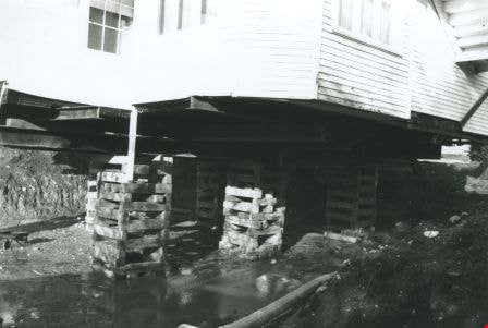
Bottom of the Britton house
https://search.heritageburnaby.ca/link/archivedescription36584
- Repository
- City of Burnaby Archives
- Date
- November 1992
- Collection/Fonds
- Burnaby Historical Society fonds
- Description Level
- Item
- Physical Description
- 1 photograph : b&w ; 10 x 15 cm print
- Scope and Content
- Photograph of the bottom of the Britton house during the Britton house moving project. A large pooling of water is visible at the bottom of the house as well as a wheelbarrow on the lower left side.
- Repository
- City of Burnaby Archives
- Date
- November 1992
- Collection/Fonds
- Burnaby Historical Society fonds
- Subseries
- Britton family subseries
- Physical Description
- 1 photograph : b&w ; 10 x 15 cm print
- Description Level
- Item
- Record No.
- 303-006
- Access Restriction
- No restrictions
- Reproduction Restriction
- Reproduce for fair dealing purposes only
- Accession Number
- BHS1992-44
- Scope and Content
- Photograph of the bottom of the Britton house during the Britton house moving project. A large pooling of water is visible at the bottom of the house as well as a wheelbarrow on the lower left side.
- Subjects
- Buildings - Residential - Houses
- Media Type
- Photograph
- Notes
- Title based on contents of photograph
- 1 b&w negative accompanying
- Geographic Access
- Kingsway
- Street Address
- 7505 Kingsway
- Historic Neighbourhood
- Edmonds (Historic Neighbourhood)
- Planning Study Area
- Stride Avenue Area
Images
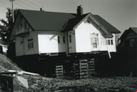
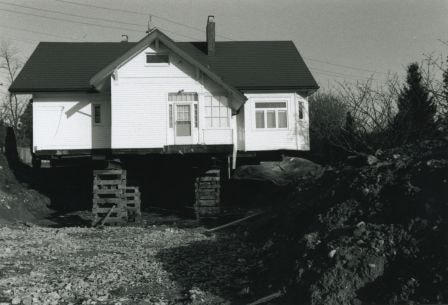
Britton house
https://search.heritageburnaby.ca/link/archivedescription36579
- Repository
- City of Burnaby Archives
- Date
- November 1992
- Collection/Fonds
- Burnaby Historical Society fonds
- Description Level
- Item
- Physical Description
- 1 photograph : b&w ; 10 x 15 cm print
- Scope and Content
- Photograph of the back door of the Britton house while the house is up on stilts.
- Repository
- City of Burnaby Archives
- Date
- November 1992
- Collection/Fonds
- Burnaby Historical Society fonds
- Subseries
- Britton family subseries
- Physical Description
- 1 photograph : b&w ; 10 x 15 cm print
- Description Level
- Item
- Record No.
- 303-001
- Access Restriction
- No restrictions
- Reproduction Restriction
- Reproduce for fair dealing purposes only
- Accession Number
- BHS1992-44
- Scope and Content
- Photograph of the back door of the Britton house while the house is up on stilts.
- Subjects
- Buildings - Residential - Houses
- Media Type
- Photograph
- Notes
- Title based on contents of photograph
- 1 b&w negative accompanying
- Geographic Access
- Kingsway
- Street Address
- 7505 Kingsway
- Historic Neighbourhood
- Edmonds (Historic Neighbourhood)
- Planning Study Area
- Stride Avenue Area
Images
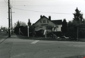
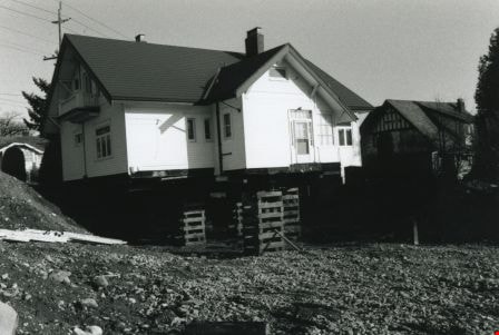
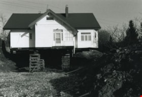
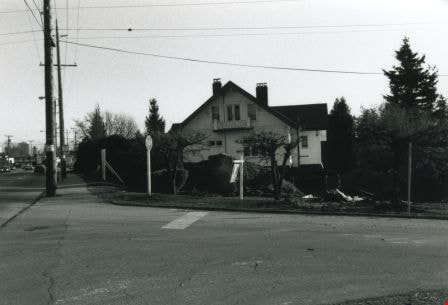
Britton house from across the street
https://search.heritageburnaby.ca/link/archivedescription36582
- Repository
- City of Burnaby Archives
- Date
- November 1992
- Collection/Fonds
- Burnaby Historical Society fonds
- Description Level
- Item
- Physical Description
- 1 photograph : b&w ; 10 x 15 cm print
- Scope and Content
- Photograph of the side of the Britton house during the Britton house moving project, taken across the street from the house.
- Repository
- City of Burnaby Archives
- Date
- November 1992
- Collection/Fonds
- Burnaby Historical Society fonds
- Subseries
- Britton family subseries
- Physical Description
- 1 photograph : b&w ; 10 x 15 cm print
- Description Level
- Item
- Record No.
- 303-004
- Access Restriction
- No restrictions
- Reproduction Restriction
- Reproduce for fair dealing purposes only
- Accession Number
- BHS1992-44
- Scope and Content
- Photograph of the side of the Britton house during the Britton house moving project, taken across the street from the house.
- Subjects
- Buildings - Residential - Houses
- Media Type
- Photograph
- Notes
- Title based on contents of photograph
- 1 b&w negative accompanying
- Geographic Access
- Kingsway
- Street Address
- 7505 Kingsway
- Historic Neighbourhood
- Edmonds (Historic Neighbourhood)
- Planning Study Area
- Stride Avenue Area
Images
![Burnaby Public Market, [1982] (date of original), copied ca. 2002 thumbnail](/media/hpo/_Data/_Archives_Images/_Unrestricted/371/426-001.jpg?width=280)
Burnaby Public Market
https://search.heritageburnaby.ca/link/archivedescription38396
- Repository
- City of Burnaby Archives
- Date
- [1982] (date of original), copied ca. 2002
- Collection/Fonds
- Burnaby Historical Society fonds
- Description Level
- Item
- Physical Description
- 1 photograph : b&w ; 12.5 x 17.7 cm print
- Scope and Content
- Photograph of the Burnaby Public Market at Kingsway and 15th avenue.
- Repository
- City of Burnaby Archives
- Date
- [1982] (date of original), copied ca. 2002
- Collection/Fonds
- Burnaby Historical Society fonds
- Subseries
- New Westminster Public Library subseries
- Physical Description
- 1 photograph : b&w ; 12.5 x 17.7 cm print
- Description Level
- Item
- Record No.
- 426-001
- Access Restriction
- No restrictions
- Reproduction Restriction
- No restrictions
- Accession Number
- BHS2002-8
- Scope and Content
- Photograph of the Burnaby Public Market at Kingsway and 15th avenue.
- Names
- Burnaby Public Market
- Media Type
- Photograph
- Notes
- Title based on contents of photograph.
- Geographic Access
- Kingsway
- 15th Avenue
- Historic Neighbourhood
- Edmonds (Historic Neighbourhood)
- Planning Study Area
- Edmonds Area
Images
![Burnaby Public Market, [1982] (date of original), copied ca. 2002 thumbnail](/media/hpo/_Data/_Archives_Images/_Unrestricted/371/426-001.jpg)
![Burnaby's first Municipal Hall, [between 1899 and 1911] (date of original), copied 1995 thumbnail](/media/hpo/_Data/_Archives_Images/_Unrestricted/316/316-006.jpg?width=280)
Burnaby's first Municipal Hall
https://search.heritageburnaby.ca/link/archivedescription37100
- Repository
- City of Burnaby Archives
- Date
- [between 1899 and 1911] (date of original), copied 1995
- Collection/Fonds
- Burnaby Historical Society fonds
- Description Level
- Item
- Physical Description
- 1 photograph : b&w ; 10 x 15 cm print
- Scope and Content
- Photograph of council members and others sitting and standing on the steps of Burnaby's first Municipal Hall.
- Repository
- City of Burnaby Archives
- Date
- [between 1899 and 1911] (date of original), copied 1995
- Collection/Fonds
- Burnaby Historical Society fonds
- Subseries
- Byrne family subseries
- Physical Description
- 1 photograph : b&w ; 10 x 15 cm print
- Description Level
- Item
- Record No.
- 316-006
- Access Restriction
- No restrictions
- Reproduction Restriction
- No known restrictions
- Accession Number
- BHS1995-04
- Scope and Content
- Photograph of council members and others sitting and standing on the steps of Burnaby's first Municipal Hall.
- Names
- Burnaby City Hall
- Media Type
- Photograph
- Notes
- Title based on contents of photograph
- Geographic Access
- Kingsway
- Street Address
- 7252 Kingsway
- Historic Neighbourhood
- Edmonds (Historic Neighbourhood)
- Planning Study Area
- Stride Avenue Area
Images
![Burnaby's first Municipal Hall, [between 1899 and 1911] (date of original), copied 1995 thumbnail](/media/hpo/_Data/_Archives_Images/_Unrestricted/316/316-006.jpg)
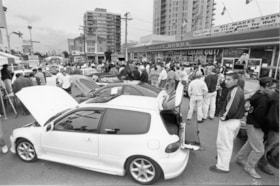
Car show at Middlegate Honda
https://search.heritageburnaby.ca/link/archivedescription78572
- Repository
- City of Burnaby Archives
- Date
- October 4, 1995
- Collection/Fonds
- Burnaby NewsLeader photograph collection
- Description Level
- Item
- Physical Description
- 1 photograph : b&w ; 15.5 x 23.5 cm
- Scope and Content
- Photograph of a car show at Middlegate Honda with a crowd of people.
- Repository
- City of Burnaby Archives
- Date
- October 4, 1995
- Collection/Fonds
- Burnaby NewsLeader photograph collection
- Physical Description
- 1 photograph : b&w ; 15.5 x 23.5 cm
- Description Level
- Item
- Record No.
- 535-0009
- Access Restriction
- No restrictions
- Reproduction Restriction
- No reproduction permitted
- Accession Number
- 2012-11
- Scope and Content
- Photograph of a car show at Middlegate Honda with a crowd of people.
- Media Type
- Photograph
- Photographer
- Langdeau, Brian
- Notes
- Title based on contents of photograph
- Note in black ink on recto of photograph reads: "Bby p. 10 Brian 2734A / 62%"
- Trim marks and/or reproduction instructions on recto (scan is cropped)
- Geographic Access
- Kingsway
Images


Central Park Pharmacy
https://search.heritageburnaby.ca/link/archivedescription35024
- Repository
- City of Burnaby Archives
- Date
- July 1986
- Collection/Fonds
- Burnaby Historical Society fonds
- Description Level
- Item
- Physical Description
- 1 photograph : b&w ; 8.8 x 12.5 cm
- Scope and Content
- Photograph of the exterior of the Central Park Pharmacy and Post Office, 3967 Kingsway at Jersey Avenue. Signs read, "Central Park Pharmacy," "Post Office," and "Drugs." A view east down Kingsway can be seen on the right side of the photo. There is an automobile parked on the street, a firehydra…
- Repository
- City of Burnaby Archives
- Date
- July 1986
- Collection/Fonds
- Burnaby Historical Society fonds
- Subseries
- Evelyn Salisbury subseries
- Physical Description
- 1 photograph : b&w ; 8.8 x 12.5 cm
- Description Level
- Item
- Record No.
- 177-001
- Access Restriction
- No restrictions
- Reproduction Restriction
- Reproduce for fair dealing purposes only
- Accession Number
- BHS1986-25
- Scope and Content
- Photograph of the exterior of the Central Park Pharmacy and Post Office, 3967 Kingsway at Jersey Avenue. Signs read, "Central Park Pharmacy," "Post Office," and "Drugs." A view east down Kingsway can be seen on the right side of the photo. There is an automobile parked on the street, a firehydrant in the left corner of the photo, and apartment buildings in the background.
- Subjects
- Buildings - Commercial - Drugstores
- Names
- Central Park Pharmacy
- Media Type
- Photograph
- Notes
- Title based on contents of photograph
- Geographic Access
- Kingsway
- Jersey Avenue
- Street Address
- 3967 Kingsway
- Historic Neighbourhood
- Central Park (Historic Neighbourhood)
- Planning Study Area
- Garden Village Area
Images


Central Park Pharmacy
https://search.heritageburnaby.ca/link/archivedescription35025
- Repository
- City of Burnaby Archives
- Date
- July 1986
- Collection/Fonds
- Burnaby Historical Society fonds
- Description Level
- Item
- Physical Description
- 1 photograph : b&w ; 8.8 x 12.5 cm
- Scope and Content
- Photograph of the Central Park Pharmacy and Post Office, 3967 Kingsway at Jersey Avenue. A view north up Jersey Avenue can be seen at the left side of the photograph, and Kingsway can be seen at the front and right side of the photo. Signs read, "Central Park Pharmacy," "Drugs," and "Central Park…
- Repository
- City of Burnaby Archives
- Date
- July 1986
- Collection/Fonds
- Burnaby Historical Society fonds
- Subseries
- Evelyn Salisbury subseries
- Physical Description
- 1 photograph : b&w ; 8.8 x 12.5 cm
- Description Level
- Item
- Record No.
- 177-002
- Access Restriction
- No restrictions
- Reproduction Restriction
- Reproduce for fair dealing purposes only
- Accession Number
- BHS1986-25
- Scope and Content
- Photograph of the Central Park Pharmacy and Post Office, 3967 Kingsway at Jersey Avenue. A view north up Jersey Avenue can be seen at the left side of the photograph, and Kingsway can be seen at the front and right side of the photo. Signs read, "Central Park Pharmacy," "Drugs," and "Central Park." Automobiles and a truck are parked on the street. The north shore mountains can be seen in the background.
- Subjects
- Buildings - Commercial - Drugstores
- Names
- Central Park Pharmacy
- Media Type
- Photograph
- Notes
- Title based on contents of photograph
- Geographic Access
- Kingsway
- Jersey Avenue
- Street Address
- 3967 Kingsway
- Historic Neighbourhood
- Central Park (Historic Neighbourhood)
- Planning Study Area
- Garden Village Area
Images
