Narrow Results By
Subject
- Advertising Medium - Signs and Signboards 13
- Aerial Photographs 8
- Animals - Cats 1
- Arts - Paintings 1
- Buildings - Civic - Fire Halls 1
- Buildings - Civic - Libraries 1
- Buildings - Commercial 12
- Buildings - Commercial - Automobile Dealerships 1
- Buildings - Commercial - Banks 2
- Buildings - Commercial - Barber Shops 1
- Buildings - Commercial - Butcher Shops 1
- Buildings - Commercial - Drugstores 1

Highrises on Kingsway
https://search.heritageburnaby.ca/link/archivedescription93692
- Repository
- City of Burnaby Archives
- Date
- June 4, 1978
- Collection/Fonds
- Burnaby Public Library Contemporary Visual Archive Project
- Description Level
- Item
- Physical Description
- 1 photograph : b&w ; 12.5 x 17.5 cm
- Scope and Content
- Photograph of high-rises apartment buildings and the neighbourhood along Kingsway by Central Park. The photograph is taken from a high point, facing east down Kingsway. The Central Park Veterinary Hospital, Central Park Place, a railway crossing, a gas station, and the Central Park Gate are visible…
- Repository
- City of Burnaby Archives
- Date
- June 4, 1978
- Collection/Fonds
- Burnaby Public Library Contemporary Visual Archive Project
- Physical Description
- 1 photograph : b&w ; 12.5 x 17.5 cm
- Description Level
- Item
- Record No.
- 556-649
- Access Restriction
- No restrictions
- Reproduction Restriction
- Reproduce for fair dealing purposes only
- Accession Number
- 2017-57
- Scope and Content
- Photograph of high-rises apartment buildings and the neighbourhood along Kingsway by Central Park. The photograph is taken from a high point, facing east down Kingsway. The Central Park Veterinary Hospital, Central Park Place, a railway crossing, a gas station, and the Central Park Gate are visible in the photograph.
- Subjects
- Buildings - Commercial
- Buildings - Residential - Apartments
- Buildings - Commercial - Service Stations
- Geographic Features - Parks
- Monuments
- Media Type
- Photograph
- Photographer
- Chapman, Fred
- Notes
- Title taken from project information form
- Accompanied by a project information form and 1 photograph (b&w negative ; 9.5 x 12.5 cm)
- BPL no. 97
- Geographic Access
- Kingsway
- Central Park
- Historic Neighbourhood
- Central Park (Historic Neighbourhood)
- Planning Study Area
- Maywood Area
Images


House at 4295 Parkwood Crescent
https://search.heritageburnaby.ca/link/archivedescription78962
- Repository
- City of Burnaby Archives
- Date
- September 16,1976
- Collection/Fonds
- Burnaby Public Library Contemporary Visual Archive Project
- Description Level
- Item
- Physical Description
- 1 photograph : b&w ; 11 x 16 cm mounted on cardboard
- Scope and Content
- Photograph shows a house at 4295 Parkwood Crescent built in 1955. At the time the photograph was taken, the street was littered with garbage.
- Repository
- City of Burnaby Archives
- Date
- September 16,1976
- Collection/Fonds
- Burnaby Public Library Contemporary Visual Archive Project
- Physical Description
- 1 photograph : b&w ; 11 x 16 cm mounted on cardboard
- Description Level
- Item
- Record No.
- 556-053
- Access Restriction
- No restrictions
- Reproduction Restriction
- Reproduce for fair dealing purposes only
- Accession Number
- 2013-13
- Scope and Content
- Photograph shows a house at 4295 Parkwood Crescent built in 1955. At the time the photograph was taken, the street was littered with garbage.
- Media Type
- Photograph
- Photographer
- Norton, Paul
- Notes
- Scope note taken directly from BPL photograph description.
- 1 b&w copy negative : 10 x 12.5 cm accompanying
- Geographic Access
- Parkwood Crescent
- Street Address
- 4295 Parkwood Crescent
- Historic Neighbourhood
- Central Park (Historic Neighbourhood)
- Planning Study Area
- Garden Village Area
Images

House at 4551 Price Street
https://search.heritageburnaby.ca/link/archivedescription78919
- Repository
- City of Burnaby Archives
- Date
- November 1, 1976
- Collection/Fonds
- Burnaby Public Library Contemporary Visual Archive Project
- Description Level
- Item
- Physical Description
- 1 photograph : b&w ; 11 x 16 cm mounted on cardboard
- Scope and Content
- Photograph shows a house located at 4551 Price Street.
- Repository
- City of Burnaby Archives
- Date
- November 1, 1976
- Collection/Fonds
- Burnaby Public Library Contemporary Visual Archive Project
- Physical Description
- 1 photograph : b&w ; 11 x 16 cm mounted on cardboard
- Description Level
- Item
- Record No.
- 556-034
- Access Restriction
- No restrictions
- Reproduction Restriction
- Reproduce for fair dealing purposes only
- Accession Number
- 2013-13
- Scope and Content
- Photograph shows a house located at 4551 Price Street.
- Media Type
- Photograph
- Notes
- Scope note taken directly from BPL photograph description.
- 1 b&w copy negative : 10 x 12.5 cm accompanying
- Photographers identified by surnames only: Carr and Vardeman
- Geographic Access
- Price Street
- Street Address
- 4551 Price Street
- Historic Neighbourhood
- Central Park (Historic Neighbourhood)
- Planning Study Area
- Marlborough Area
Images
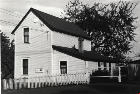

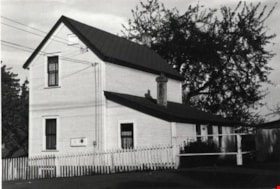
House at 5170 Boundary Road
https://search.heritageburnaby.ca/link/archivedescription78963
- Repository
- City of Burnaby Archives
- Date
- September 9,1976
- Collection/Fonds
- Burnaby Public Library Contemporary Visual Archive Project
- Description Level
- Item
- Physical Description
- 1 photograph : b&w ; 11 x 16 cm mounted on cardboard
- Scope and Content
- Photograph shows a house at 5170 Boundary Road on the corner of Burke Street. The house was constructed in 1911. The home is known as the Minerva Jane Coburn house.
- Repository
- City of Burnaby Archives
- Date
- September 9,1976
- Collection/Fonds
- Burnaby Public Library Contemporary Visual Archive Project
- Physical Description
- 1 photograph : b&w ; 11 x 16 cm mounted on cardboard
- Description Level
- Item
- Record No.
- 556-054
- Access Restriction
- No restrictions
- Reproduction Restriction
- Reproduce for fair dealing purposes only
- Accession Number
- 2013-13
- Scope and Content
- Photograph shows a house at 5170 Boundary Road on the corner of Burke Street. The house was constructed in 1911. The home is known as the Minerva Jane Coburn house.
- Subjects
- Buildings - Heritage
- Media Type
- Photograph
- Photographer
- Norton, Paul
- Notes
- Scope note taken directly from BPL photograph description.
- 1 b&w copy negative : 10 x 12.5 cm accompanying
- Geographic Access
- Boundary Road
- Street Address
- 5170 Boundary Road
- Historic Neighbourhood
- Central Park (Historic Neighbourhood)
- Planning Study Area
- Garden Village Area
Images


House at 5625 Willingdon Avenue
https://search.heritageburnaby.ca/link/archivedescription78904
- Repository
- City of Burnaby Archives
- Date
- September 12, 1976
- Collection/Fonds
- Burnaby Public Library Contemporary Visual Archive Project
- Description Level
- Item
- Physical Description
- 1 photograph : b&w ; 11 x 16 cm mounted on cardboard
- Scope and Content
- Photograph shows a house at 5625 Willingdon Avenue.
- Repository
- City of Burnaby Archives
- Date
- September 12, 1976
- Collection/Fonds
- Burnaby Public Library Contemporary Visual Archive Project
- Physical Description
- 1 photograph : b&w ; 11 x 16 cm mounted on cardboard
- Description Level
- Item
- Record No.
- 556-026
- Access Restriction
- No restrictions
- Reproduction Restriction
- Reproduce for fair dealing purposes only
- Accession Number
- 2013-13
- Scope and Content
- Photograph shows a house at 5625 Willingdon Avenue.
- Media Type
- Photograph
- Photographer
- Norton, Paul
- Notes
- Scope note taken directly from BPL photograph description.
- 1 b&w copy negative : 10 x 12.5 cm accompanying
- Geographic Access
- Willingdon Avenue
- Street Address
- 5625 Willingdon Avenue
- Historic Neighbourhood
- Central Park (Historic Neighbourhood)
- Planning Study Area
- Garden Village Area
Images


House at 6236 McMurray Avenue
https://search.heritageburnaby.ca/link/archivedescription78918
- Repository
- City of Burnaby Archives
- Date
- February 7, 1977
- Collection/Fonds
- Burnaby Public Library Contemporary Visual Archive Project
- Description Level
- Item
- Physical Description
- 1 photograph : b&w ; 11 x 16 cm mounted on cardboard
- Scope and Content
- Photograph shows cars in front of a house located at 6236 McMurray Avenue with a high-rise apartment building in the background.
- Repository
- City of Burnaby Archives
- Date
- February 7, 1977
- Collection/Fonds
- Burnaby Public Library Contemporary Visual Archive Project
- Physical Description
- 1 photograph : b&w ; 11 x 16 cm mounted on cardboard
- Description Level
- Item
- Record No.
- 556-033
- Access Restriction
- No restrictions
- Reproduction Restriction
- Reproduce for fair dealing purposes only
- Accession Number
- 2013-13
- Scope and Content
- Photograph shows cars in front of a house located at 6236 McMurray Avenue with a high-rise apartment building in the background.
- Media Type
- Photograph
- Notes
- Scope note taken directly from BPL photograph description.
- 1 b&w copy negative : 10 x 12.5 cm accompanying
- Photographers identified by surnames only: Carr and Vardeman
- Geographic Access
- McMurray Avenue
- Street Address
- 6236 McMurray Avenue
- Historic Neighbourhood
- Central Park (Historic Neighbourhood)
- Planning Study Area
- Marlborough Area
Images


House at 6262 Nelson Avenue
https://search.heritageburnaby.ca/link/archivedescription78951
- Repository
- City of Burnaby Archives
- Date
- September 15,1976
- Collection/Fonds
- Burnaby Public Library Contemporary Visual Archive Project
- Description Level
- Item
- Physical Description
- 1 photograph : b&w ; 11 x 16 cm mounted on cardboard
- Scope and Content
- Photograph shows a house at 6262 Nelson Avenue, near Kingsway, with a high-rise apartment building in the background.
- Repository
- City of Burnaby Archives
- Date
- September 15,1976
- Collection/Fonds
- Burnaby Public Library Contemporary Visual Archive Project
- Physical Description
- 1 photograph : b&w ; 11 x 16 cm mounted on cardboard
- Description Level
- Item
- Record No.
- 556-046
- Access Restriction
- No restrictions
- Reproduction Restriction
- Reproduce for fair dealing purposes only
- Accession Number
- 2013-13
- Scope and Content
- Photograph shows a house at 6262 Nelson Avenue, near Kingsway, with a high-rise apartment building in the background.
- Subjects
- Buildings - Residential - Apartments
- Media Type
- Photograph
- Photographer
- McCarron, John
- Notes
- Scope note taken directly from BPL photograph description.
- 1 b&w copy negative : 10 x 12.5 cm accompanying
- Geographic Access
- Nelson Avenue
- Street Address
- 6262 Nelson Avenue
- Historic Neighbourhood
- Central Park (Historic Neighbourhood)
- Planning Study Area
- Marlborough Area
Images


House at 6521 Bonsor Avenue
https://search.heritageburnaby.ca/link/archivedescription78902
- Repository
- City of Burnaby Archives
- Date
- September 13, 1976
- Collection/Fonds
- Burnaby Public Library Contemporary Visual Archive Project
- Description Level
- Item
- Physical Description
- 1 photograph : b&w ; 11 x 16 cm mounted on cardboard
- Scope and Content
- Photograph shows a house at 6521 Bonsor Avenue. The house was originally built in 1927 and was in the Digney family since 1946. Their bowling alley was connected to the back of the house.
- Repository
- City of Burnaby Archives
- Date
- September 13, 1976
- Collection/Fonds
- Burnaby Public Library Contemporary Visual Archive Project
- Physical Description
- 1 photograph : b&w ; 11 x 16 cm mounted on cardboard
- Description Level
- Item
- Record No.
- 556-025
- Access Restriction
- No restrictions
- Reproduction Restriction
- Reproduce for fair dealing purposes only
- Accession Number
- 2013-13
- Scope and Content
- Photograph shows a house at 6521 Bonsor Avenue. The house was originally built in 1927 and was in the Digney family since 1946. Their bowling alley was connected to the back of the house.
- Media Type
- Photograph
- Photographer
- McCarron, John
- Notes
- Scope note taken directly from BPL photograph description.
- 1 b&w copy negative : 10 x 12.5 cm accompanying
- Geographic Access
- Bonsor Avenue
- Street Address
- 6521 Bonsor Avenue
- Historic Neighbourhood
- Central Park (Historic Neighbourhood)
- Planning Study Area
- Maywood Area
Images
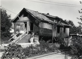
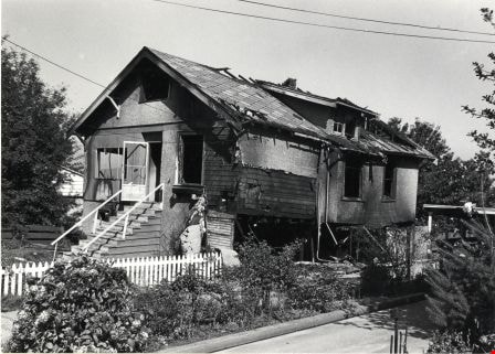
House on Nelson Avenue
https://search.heritageburnaby.ca/link/archivedescription78909
- Repository
- City of Burnaby Archives
- Date
- September 15, 1976
- Collection/Fonds
- Burnaby Public Library Contemporary Visual Archive Project
- Description Level
- Item
- Physical Description
- 1 photograph : b&w ; 11 x 16 cm mounted on cardboard
- Scope and Content
- Photograph shows a burned out house on Nelson Avenue near Maitland Street. A basement fire destroyed the house a few days before the photograph was taken.
- Repository
- City of Burnaby Archives
- Date
- September 15, 1976
- Collection/Fonds
- Burnaby Public Library Contemporary Visual Archive Project
- Physical Description
- 1 photograph : b&w ; 11 x 16 cm mounted on cardboard
- Description Level
- Item
- Record No.
- 556-027
- Access Restriction
- No restrictions
- Reproduction Restriction
- Reproduce for fair dealing purposes only
- Accession Number
- 2013-13
- Scope and Content
- Photograph shows a burned out house on Nelson Avenue near Maitland Street. A basement fire destroyed the house a few days before the photograph was taken.
- Media Type
- Photograph
- Photographer
- McCarron, John
- Notes
- Scope note taken directly from BPL photograph description.
- 1 b&w copy negative : 10 x 12.5 cm accompanying
- Geographic Access
- Nelson Avenue
- Historic Neighbourhood
- Central Park (Historic Neighbourhood)
- Planning Study Area
- Marlborough Area
Images
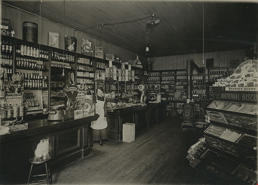
![Interior of a Kingsway Store, [190-] (date of original), copied 1976 thumbnail](/media/hpo/_Data/_BVM_Images/1976/1976_0153_0001_001.jpg?width=280)
Interior of a Kingsway Store
https://search.heritageburnaby.ca/link/museumdescription842
- Repository
- Burnaby Village Museum
- Date
- [190-] (date of original), copied 1976
- Collection/Fonds
- Burnaby Village Museum Photograph collection
- Description Level
- Item
- Physical Description
- 1 photograph : b&w ; 11.5 x 16.5 cm, mounted on card 17.5 x 22.5 cm
- Scope and Content
- Photograph of the interior of what has been identified by the accession register as a Kingsway Store. Inside the store, there is a woman wearing an apron standing by the counters who has been identified as Mrs. C.B. Button. Behind the counter, a large cash register can be seen. There are weights…
- Repository
- Burnaby Village Museum
- Collection/Fonds
- Burnaby Village Museum Photograph collection
- Description Level
- Item
- Physical Description
- 1 photograph : b&w ; 11.5 x 16.5 cm, mounted on card 17.5 x 22.5 cm
- Scope and Content
- Photograph of the interior of what has been identified by the accession register as a Kingsway Store. Inside the store, there is a woman wearing an apron standing by the counters who has been identified as Mrs. C.B. Button. Behind the counter, a large cash register can be seen. There are weights, various tin cans, Rennie's seeds, Christie's biscuits, etc. on display. There is a cat sitting on a stool in front of the counter. The interior has hardwood finishing on the floor, walls and ceiling.
- Geographic Access
- Kingsway
- Nelson Avenue
- Street Address
- 4920 Kingsway
- Accession Code
- HV976.153.1
- Access Restriction
- No restrictions
- Reproduction Restriction
- May be restricted by third party rights
- Date
- [190-] (date of original), copied 1976
- Media Type
- Photograph
- Historic Neighbourhood
- Central Park (Historic Neighbourhood)
- Planning Study Area
- Marlborough Area
- Scan Resolution
- 600
- Scan Date
- 2023-06-27
- Notes
- Title based on contents of photograph
Images
![Interior of a Kingsway Store, [190-] (date of original), copied 1976 thumbnail](/media/hpo/_Data/_BVM_Images/1976/1976_0153_0001_001.jpg)
![James Smith house, [1907] thumbnail](/media/hpo/_Data/_Archives_Images/_Unrestricted/126/137-001.jpg?width=280)
James Smith house
https://search.heritageburnaby.ca/link/archivedescription34808
- Repository
- City of Burnaby Archives
- Date
- [1907]
- Collection/Fonds
- Burnaby Historical Society fonds
- Description Level
- Item
- Physical Description
- 1 photograph : b&w ; 10.0 x 14.0 cm mounted on 17.7 x 22.cm cardboard
- Scope and Content
- Photograph of the exterior of the James Smith house, 6186 Royal Oak Avenue. A woman and two girls are seated on the porch stairs. The accession description states that the house is a B.C. Mills Prefab erected in 1907 by Mr. and Mrs. Smith.
- Repository
- City of Burnaby Archives
- Date
- [1907]
- Collection/Fonds
- Burnaby Historical Society fonds
- Subseries
- Grace Pletcher subseries
- Physical Description
- 1 photograph : b&w ; 10.0 x 14.0 cm mounted on 17.7 x 22.cm cardboard
- Description Level
- Item
- Record No.
- 137-001
- Access Restriction
- No restrictions
- Reproduction Restriction
- No known restrictions
- Accession Number
- BHS1985-06
- Scope and Content
- Photograph of the exterior of the James Smith house, 6186 Royal Oak Avenue. A woman and two girls are seated on the porch stairs. The accession description states that the house is a B.C. Mills Prefab erected in 1907 by Mr. and Mrs. Smith.
- Subjects
- Buildings - Residential - Houses
- Media Type
- Photograph
- Notes
- Title based on contents of photograph
- Annotations on the back of the cardboard read, "With love from Agnes" and "Mrs H Rolfe / Charles Rd. / South Portland / Maine."
- Geographic Access
- Royal Oak Avenue
- Street Address
- 6186 Royal Oak Avenue
- Historic Neighbourhood
- Central Park (Historic Neighbourhood)
- Planning Study Area
- Windsor Area
Images
![James Smith house, [1907] thumbnail](/media/hpo/_Data/_Archives_Images/_Unrestricted/126/137-001.jpg)

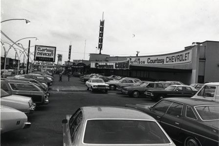
Jim Pattison Courtesy Chevrolet
https://search.heritageburnaby.ca/link/archivedescription79252
- Repository
- City of Burnaby Archives
- Date
- October 9, 1976
- Collection/Fonds
- Burnaby Public Library Contemporary Visual Archive Project
- Description Level
- Item
- Physical Description
- 1 photograph : b&w ; 11 x 16 cm mounted on cardboard
- Scope and Content
- Photograph shows cars in the lot of the Jim Pattison Courtesy Chevrolet at 5405 Kingsway. The building was originally Dueck's and was built in 1958 by Thompson, Berwick and Pratt.
- Repository
- City of Burnaby Archives
- Date
- October 9, 1976
- Collection/Fonds
- Burnaby Public Library Contemporary Visual Archive Project
- Physical Description
- 1 photograph : b&w ; 11 x 16 cm mounted on cardboard
- Description Level
- Item
- Record No.
- 556-222
- Access Restriction
- No restrictions
- Reproduction Restriction
- Reproduce for fair dealing purposes only
- Accession Number
- 2013-13
- Scope and Content
- Photograph shows cars in the lot of the Jim Pattison Courtesy Chevrolet at 5405 Kingsway. The building was originally Dueck's and was built in 1958 by Thompson, Berwick and Pratt.
- Media Type
- Photograph
- Photographer
- McCarron, John
- Notes
- Scope note taken directly from BPL photograph description.
- 1 b&w copy negative : 10 x 12.5 cm accompanying
- Geographic Access
- Kingsway
- Street Address
- 5405 Kingsway
- Historic Neighbourhood
- Central Park (Historic Neighbourhood)
- Planning Study Area
- Windsor Area
Images
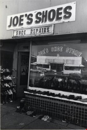
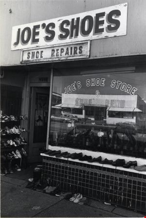
Joe's Shoe Store
https://search.heritageburnaby.ca/link/archivedescription79204
- Repository
- City of Burnaby Archives
- Date
- September 15, 1976
- Collection/Fonds
- Burnaby Public Library Contemporary Visual Archive Project
- Description Level
- Item
- Physical Description
- 1 photograph : b&w ; 11 x 16 cm mounted on cardboard
- Scope and Content
- Photograph shows Joe's Shoe Store at 4546 Kingsway.
- Repository
- City of Burnaby Archives
- Date
- September 15, 1976
- Collection/Fonds
- Burnaby Public Library Contemporary Visual Archive Project
- Physical Description
- 1 photograph : b&w ; 11 x 16 cm mounted on cardboard
- Description Level
- Item
- Record No.
- 556-205
- Access Restriction
- No restrictions
- Reproduction Restriction
- Reproduce for fair dealing purposes only
- Accession Number
- 2013-13
- Scope and Content
- Photograph shows Joe's Shoe Store at 4546 Kingsway.
- Names
- Joe's Shoe Store
- Media Type
- Photograph
- Photographer
- McCarron, John
- Notes
- Scope note taken directly from BPL photograph description.
- 1 b&w copy negative : 10 x 12.5 cm accompanying
- Geographic Access
- Kingsway
- Street Address
- 4546 Kingsway
- Historic Neighbourhood
- Central Park (Historic Neighbourhood)
- Planning Study Area
- Maywood Area
Images
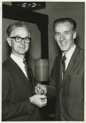
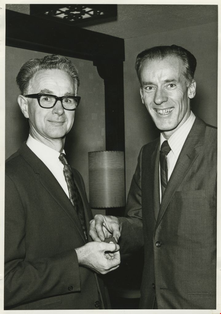
John Shaw and Mayor Bob Prittie
https://search.heritageburnaby.ca/link/archivedescription55597
- Repository
- City of Burnaby Archives
- Date
- 1971
- Collection/Fonds
- John Shaw fonds
- Description Level
- Item
- Physical Description
- 1 photograph : b&w ; 17.5 x 12.5 cm
- Scope and Content
- Photograph of John Shaw (left) receiving a long service award pin from Mayor Bob Prittie (right). The photograph was taken at the Burnaby Long Service Awards ceremony held at the Astor Hotel in 1971. John Shaw had worked for Burnaby for 35 years.
- Repository
- City of Burnaby Archives
- Date
- 1971
- Collection/Fonds
- John Shaw fonds
- Series
- Civil Service series
- Physical Description
- 1 photograph : b&w ; 17.5 x 12.5 cm
- Description Level
- Item
- Record No.
- 485-072
- Access Restriction
- No restrictions
- Reproduction Restriction
- Reproduce for fair dealing purposes only
- Accession Number
- 2005-15
- 2006-01
- 2007-18
- Scope and Content
- Photograph of John Shaw (left) receiving a long service award pin from Mayor Bob Prittie (right). The photograph was taken at the Burnaby Long Service Awards ceremony held at the Astor Hotel in 1971. John Shaw had worked for Burnaby for 35 years.
- Media Type
- Photograph
- Photographer
- LeBlanc, Don
- Notes
- Title based on contents of photograph
- Note on verso reads: "Me & Mayor Bob Prittie / Astor Hotel / Long Service Awards / 1971"
- Photographer's stamp on vrso
- Photographer identifies photograph as no. 5830
- Geographic Access
- Kingsway
- Street Address
- 4561 Kingsway
- Historic Neighbourhood
- Central Park (Historic Neighbourhood)
- Planning Study Area
- Marlborough Area
Images

Jubilee Methodist Church
https://search.heritageburnaby.ca/link/archivedescription36018
- Repository
- City of Burnaby Archives
- Date
- 1909
- Collection/Fonds
- Burnaby Historical Society fonds
- Description Level
- Item
- Physical Description
- 1 photograph : sepia postcard ; 8 x 13 cm
- Scope and Content
- Photographic postcard of the Jubilee Methodist Church.
- Repository
- City of Burnaby Archives
- Date
- 1909
- Collection/Fonds
- Burnaby Historical Society fonds
- Subseries
- Ephemera subseries
- Physical Description
- 1 photograph : sepia postcard ; 8 x 13 cm
- Description Level
- Item
- Record No.
- 212-001
- Access Restriction
- No restrictions
- Reproduction Restriction
- No known restrictions
- Accession Number
- BHS1988-12
- Scope and Content
- Photographic postcard of the Jubilee Methodist Church.
- Media Type
- Photograph
- Notes
- Title based on contents of photograph
- Geographic Access
- Sussex Avenue
- Street Address
- 6050 Sussex Avenue
- Historic Neighbourhood
- Central Park (Historic Neighbourhood)
- Planning Study Area
- Marlborough Area
Images


Kingsway
https://search.heritageburnaby.ca/link/archivedescription79943
- Repository
- City of Burnaby Archives
- Date
- September 15, 1976
- Collection/Fonds
- Burnaby Public Library Contemporary Visual Archive Project
- Description Level
- Item
- Physical Description
- 1 photograph : b&w ; 11 x 16 cm mounted on cardboard
- Scope and Content
- Photograph shows a view of Kingsway looking southeast from the 21st floor of the Panorama Towers in Grange Street. The Esso Car Clinic is in the centre of the photo.
- Repository
- City of Burnaby Archives
- Date
- September 15, 1976
- Collection/Fonds
- Burnaby Public Library Contemporary Visual Archive Project
- Physical Description
- 1 photograph : b&w ; 11 x 16 cm mounted on cardboard
- Description Level
- Item
- Record No.
- 556-514
- Access Restriction
- No restrictions
- Reproduction Restriction
- Reproduce for fair dealing purposes only
- Accession Number
- 2013-13
- Scope and Content
- Photograph shows a view of Kingsway looking southeast from the 21st floor of the Panorama Towers in Grange Street. The Esso Car Clinic is in the centre of the photo.
- Subjects
- Aerial Photographs
- Media Type
- Photograph
- Photographer
- McCarron, John
- Notes
- Scope note taken directly from BPL photograph description.
- 1 b&w copy negative : 10 x 12.5 cm accompanying
- Geographic Access
- Kingsway
- Historic Neighbourhood
- Central Park (Historic Neighbourhood)
- Planning Study Area
- Maywood Area
Images


Kingsway
https://search.heritageburnaby.ca/link/archivedescription35874
- Repository
- City of Burnaby Archives
- Date
- 1900 (date of original), copied 1986
- Collection/Fonds
- Burnaby Historical Society fonds
- Description Level
- Item
- Physical Description
- 1 photograph : b&w ; 12.7 x 17.8 cm print
- Scope and Content
- Photograph of Kingsway (then Westminster Road), looking east from Boundary Road near Central Park. Included in the photograph; Central Park Presbyterian Church, Masonic Hall and Reid's Hall.
- Repository
- City of Burnaby Archives
- Date
- 1900 (date of original), copied 1986
- Collection/Fonds
- Burnaby Historical Society fonds
- Subseries
- Pioneer Tales subseries
- Physical Description
- 1 photograph : b&w ; 12.7 x 17.8 cm print
- Description Level
- Item
- Record No.
- 204-733
- Access Restriction
- No restrictions
- Reproduction Restriction
- No known restrictions
- Accession Number
- BHS1988-03
- Scope and Content
- Photograph of Kingsway (then Westminster Road), looking east from Boundary Road near Central Park. Included in the photograph; Central Park Presbyterian Church, Masonic Hall and Reid's Hall.
- Subjects
- Buildings - Recreational - Community Halls
- Buildings - Religious - Churches
- Geographic Features - Roads
- Media Type
- Photograph
- Notes
- Title based on contents of photograph
- Geographic Access
- Westminster Avenue
- Kingsway
- Street Address
- 3777 Kingsway
- Historic Neighbourhood
- Central Park (Historic Neighbourhood)
- Planning Study Area
- Garden Village Area
Images


Kingsway and Central Park
https://search.heritageburnaby.ca/link/archivedescription79964
- Repository
- City of Burnaby Archives
- Date
- October 27, 1976
- Collection/Fonds
- Burnaby Public Library Contemporary Visual Archive Project
- Description Level
- Item
- Physical Description
- 1 photograph : b&w ; 11 x 16 cm mounted on cardboard
- Scope and Content
- Photograph shows a view of Kingsway looking west from Central Park Place.
- Repository
- City of Burnaby Archives
- Date
- October 27, 1976
- Collection/Fonds
- Burnaby Public Library Contemporary Visual Archive Project
- Physical Description
- 1 photograph : b&w ; 11 x 16 cm mounted on cardboard
- Description Level
- Item
- Record No.
- 556-527
- Access Restriction
- No restrictions
- Reproduction Restriction
- Reproduce for fair dealing purposes only
- Accession Number
- 2013-13
- Scope and Content
- Photograph shows a view of Kingsway looking west from Central Park Place.
- Subjects
- Aerial Photographs
- Media Type
- Photograph
- Photographer
- Norton, Paul
- Notes
- Scope note taken directly from BPL photograph description.
- 1 b&w copy negative : 10 x 12.5 cm accompanying
- Geographic Access
- Kingsway
- Historic Neighbourhood
- Central Park (Historic Neighbourhood)
- Planning Study Area
- Maywood Area
Images

![Kingsway at Central Park, [1908] (date of original) thumbnail](/media/hpo/_Data/_Archives_Images/_Unrestricted/251/293-001.jpg?width=280)
Kingsway at Central Park
https://search.heritageburnaby.ca/link/archivedescription36540
- Repository
- City of Burnaby Archives
- Date
- [1908] (date of original)
- Collection/Fonds
- Burnaby Historical Society fonds
- Description Level
- Item
- Physical Description
- 1 photograph : b&w ; 10 x 11.5 cm print
- Scope and Content
- Photograph of men driving horse-drawn carriages down Kingsway, east of Boundary Road. The Central Park Presbyterian Church is visible on the left, with Central Park on the right.
- Repository
- City of Burnaby Archives
- Date
- [1908] (date of original)
- Collection/Fonds
- Burnaby Historical Society fonds
- Subseries
- John DeForest subseries
- Physical Description
- 1 photograph : b&w ; 10 x 11.5 cm print
- Description Level
- Item
- Record No.
- 293-001
- Access Restriction
- No restrictions
- Reproduction Restriction
- No known restrictions
- Accession Number
- BHS1992-30
- Scope and Content
- Photograph of men driving horse-drawn carriages down Kingsway, east of Boundary Road. The Central Park Presbyterian Church is visible on the left, with Central Park on the right.
- Media Type
- Photograph
- Notes
- Title based on contents of photograph
- Geographic Access
- Central Park
- Kingsway
- Historic Neighbourhood
- Central Park (Historic Neighbourhood)
- Planning Study Area
- Maywood Area
Images
![Kingsway at Central Park, [1908] (date of original) thumbnail](/media/hpo/_Data/_Archives_Images/_Unrestricted/251/293-001.jpg)
![Lancelot Grimmer house, [1905] thumbnail](/media/hpo/_Data/_Archives_Images/_Unrestricted/251/290-001.jpg?width=280)
Lancelot Grimmer house
https://search.heritageburnaby.ca/link/archivedescription36531
- Repository
- City of Burnaby Archives
- Date
- [1905]
- Collection/Fonds
- Burnaby Historical Society fonds
- Description Level
- Item
- Physical Description
- 1 photograph : b&w ; 9 x 13 cm print
- Scope and Content
- Photograph of Martha Jane, Irene & Cynthia (Martha Jane's sister) Grimmer standing on the front porch of the Lancelot and Martha Jane Grimmer House.
- Repository
- City of Burnaby Archives
- Date
- [1905]
- Collection/Fonds
- Burnaby Historical Society fonds
- Subseries
- Grimmer family subseries
- Physical Description
- 1 photograph : b&w ; 9 x 13 cm print
- Description Level
- Item
- Record No.
- 290-001
- Access Restriction
- No restrictions
- Reproduction Restriction
- No known restrictions
- Accession Number
- BHS1992-26
- Scope and Content
- Photograph of Martha Jane, Irene & Cynthia (Martha Jane's sister) Grimmer standing on the front porch of the Lancelot and Martha Jane Grimmer House.
- Subjects
- Buildings - Residential - Houses
- Media Type
- Photograph
- Notes
- Title based on contents of photograph
- Geographic Access
- Grimmer Street
- Historic Neighbourhood
- Central Park (Historic Neighbourhood)
- Planning Study Area
- Windsor Area
Images
![Lancelot Grimmer house, [1905] thumbnail](/media/hpo/_Data/_Archives_Images/_Unrestricted/251/290-001.jpg)