Narrow Results By
Interview with John Kirbyson by Kathy Bossort September 28, 2015 - Track 4
https://search.heritageburnaby.ca/link/oralhistory559
- Repository
- City of Burnaby Archives
- Date Range
- 1980-2005
- Length
- 0:14:23
- Summary
- This portion of the interview is about John Kirbyson’s impression of the dispute between SFU and the City of Burnaby over land use and control on Burnaby Mountain, and Parks Dept. interests in the negotiations and agreement. He talks about how changing public values and perception of safety issues …
- Repository
- City of Burnaby Archives
- Summary
- This portion of the interview is about John Kirbyson’s impression of the dispute between SFU and the City of Burnaby over land use and control on Burnaby Mountain, and Parks Dept. interests in the negotiations and agreement. He talks about how changing public values and perception of safety issues affects parks management.
- Date Range
- 1980-2005
- Length
- 0:14:23
- Names
- Simon Fraser University
- Burnaby Parks, Recreation and Cultural Services Department
- Mancinelli, Stephen J. "Steve"
- Geographic Access
- Burnaby Mountain Conservation Area
- Central Park
- Interviewer
- Bossort, Kathy
- Interview Date
- September 28, 2015
- Scope and Content
- Recording is of an interview with John Kirbyson conducted by Kathy Bossort. John Kirbyson was one of 23 participants interviewed as part of the Community Heritage Commission’s Burnaby Mountain Oral History Project. The interview is mainly about John Kirbyson’s education and career as parks planner for the City of Burnaby Parks, Recreation and Cultural Services, and the development of the 1999 Burnaby Mountain Conservation Area Management Plan. The interview explores how parks management balances environmental and recreational values and safety, and the importance of good guidelines and public input in the parks planning process. John Kirbyson also talks about recreational activities and various developments on Burnaby Mountain in the 1990s, such as the Kamui Mintara sculptures.
- Biographical Notes
- John Kirbyson was born in Vancouver in 1954, to Arnold and Winnifred Kirbyson. After several years spent in Winnipeg and Calgary, the Kirbyson family moved to Hunter Street in Burnaby in 1969 where John remembers living near the City’s nursery. John earned his BSc degree at SFU in Physical Geography (1973-1978) and then worked for the City of Burnaby Parks, Recreation and Cultural Services between 1978 and 2005, where he moved from labourer to management positions. Supported by the City, he returned to SFU to earn his Masters degree in the School of Resource and Environment Management in 1991, his thesis being on restoration of Deer Lake. He was Manager of Parks Planning, Design and Development in the 1990s at the time that land on Burnaby Mountain was transferred from SFU to the City of Burnaby, and had the opportunity to direct the development of the first management plan for the Burnaby Mountain Conservation Area. From 2005 to 2010 John was Manager of the Parks, Recreation and Culture Dept. in Penticton, after which he has worked as an environmental consultant for Lees & Associates Landscape Architects and Planners. He is married to wife Linda and has three children: Linnaea, Jeremy and Colin.
- Total Tracks
- 7
- Total Length
- 1:33:43
- Interviewee Name
- Kirbyson, John W.
- Interview Location
- John Kirbyson's son's home in Langley
- Interviewer Bio
- Kathy Bossort is a retired archivist living in Ladner, BC. She worked at the Delta Museum and Archives after graduating from SLAIS (UBC) in 2001 with Masters degrees in library science and archival studies. Kathy grew up in Calgary, Alberta, and, prior to this career change, she lived in the West Kootenays, earning her living as a cook for BC tourist lodges and work camps. She continues to be interested in oral histories as a way to fill the gaps in the written record and bring richer meaning to history.
- Collection/Fonds
- Community Heritage Commission Special Projects fonds
- Media Type
- Sound Recording
Audio Tracks
Track four of interview with John Kirbyson
Track four of interview with John Kirbyson
https://search.heritageburnaby.ca/media/hpo/_Data/_Archives_Oral_Histories/_Unrestricted/MSS196-002/MSS196-002_Track_4.mp3Survey and Subdivision plans in New Westminster District Group 1 – Burnaby
https://search.heritageburnaby.ca/link/museumdescription6971
- Repository
- Burnaby Village Museum
- Date
- 1904-1908
- Collection/Fonds
- Burnaby Village Museum Map collection
- Description Level
- File
- Physical Description
- 7 plans : blueprint ink on paper mounted on 2 sides of cardboard 76 cm x 101.5 cm
- Scope and Content
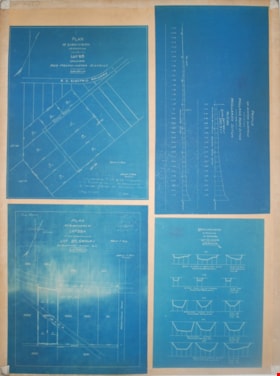
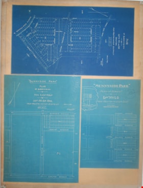
- Item consists of a large board of four New Westminster District Gp 1 -subdivision plans mounted on one side and three New Westminster District Gp 1 - subdivision plans mounted on the other side. Side A: 1. Blueprint "Plan / of Subdivision of / Lot 28A / in Subdivision of / Lot 97, Group 1 / Ne…
- Repository
- Burnaby Village Museum
- Collection/Fonds
- Burnaby Village Museum Map collection
- Description Level
- File
- Physical Description
- 7 plans : blueprint ink on paper mounted on 2 sides of cardboard 76 cm x 101.5 cm
- Material Details
- Scales [between1:120 and 1:3960]
- Index number on edge of board reads: "3"
- Scope and Content
- Item consists of a large board of four New Westminster District Gp 1 -subdivision plans mounted on one side and three New Westminster District Gp 1 - subdivision plans mounted on the other side. Side A: 1. Blueprint "Plan / of Subdivision of / Lot 28A / in Subdivision of / Lot 97, Group 1 / New Westminster District". The B.C.E.R. is identified running through the subdivision of XXVIIIA (Lot 28A). Plan is dated "Sept. 21st, 08" (Geographic location: Burnaby) 2. Blueprint "Measurements / of Discharge / in Ditches / Lots 155A, G.One" / "Scale, Twentieths. / 17/12/04" (Geographic location: Burnaby) 3. Blueprint "Plan / of Subdivision / of a portion of / Lot 95 / Group One / New Westminster District" B.C. Electric Railway runs through the top of the plan. The plan is dated May 23, 1906. (Geographic location: Burnaby) 4. Blueprint " Profile / on Water Surface / in / Holland Road Ditch / Woollard's Ditch / Dec. 3rd 1904 / Scales Hor. 200'=1" / Vert. 10'=1"" (Geographic location: Burnaby) Side B: 1. Blueprint " "Sunnyside Park" / plan of Subdivision / of / the East Half / of / Lot 39, GR.One, / New Westminster District / Scale 100'=1" (Geographic location: Burnaby) 2. Blueprint " "Sunnyside Park"/ plan of Subdivi..n / of / Lot 39, Gr.1. / New Westminster District" Index in upper left corner of plan shows location of Lot 39 in relation to Central Park and surrounding Lots. (Geographic location: Burnaby) 3. Blueprint "Plan / of Subdivision / of / Lot 163 and 165 / Group One / New Westminster District / Scale 5 chs=1 in." Streets within subdivision plan are identified as; North Arm Road, Ingram Street, Blair Street, Kennedy Street, Murray Street, Wiggins Road, Byrne Road, South Road along with North Arm Fraser River and B.C. Electric Railway. (Geographic location: Burnaby)
- Geographic Access
- Central Park
- Accession Code
- HV977.93.3
- Access Restriction
- No restrictions
- Reproduction Restriction
- No known restrictions
- Date
- 1904-1908
- Media Type
- Cartographic Material
- Historic Neighbourhood
- Central Park (Historic Neighbourhood)
- Scan Resolution
- 300
- Scale
- 72
- Notes
- Title based on contents of file
- Scale is measured in chains and feet. (One chain equals 792 inches)
- The term "Lot" can also refer to a "District Lot”

