Narrow Results By
Subject
- Advertising Medium - Signs and Signboards 2
- Aerial Photographs 2
- Animals - Dogs 2
- Animals - Horses 1
- Arts - Paintings 1
- Buildings 1
- Buildings - Civic 1
- Buildings - Commercial 6
- Buildings - Commercial - Drive-In Theatres 1
- Buildings - Commercial - General Stores 1
- Buildings - Commercial - Hotels and Motels 2
- Buildings - Commercial - Malls 1

Patterson Family Home
https://search.heritageburnaby.ca/link/archivedescription35208
- Repository
- City of Burnaby Archives
- Date
- 1908 (date of original), copied 1986
- Collection/Fonds
- Burnaby Historical Society fonds
- Description Level
- Item
- Physical Description
- 1 photograph : b&w ; 12.7 x 17.8 cm print
- Scope and Content
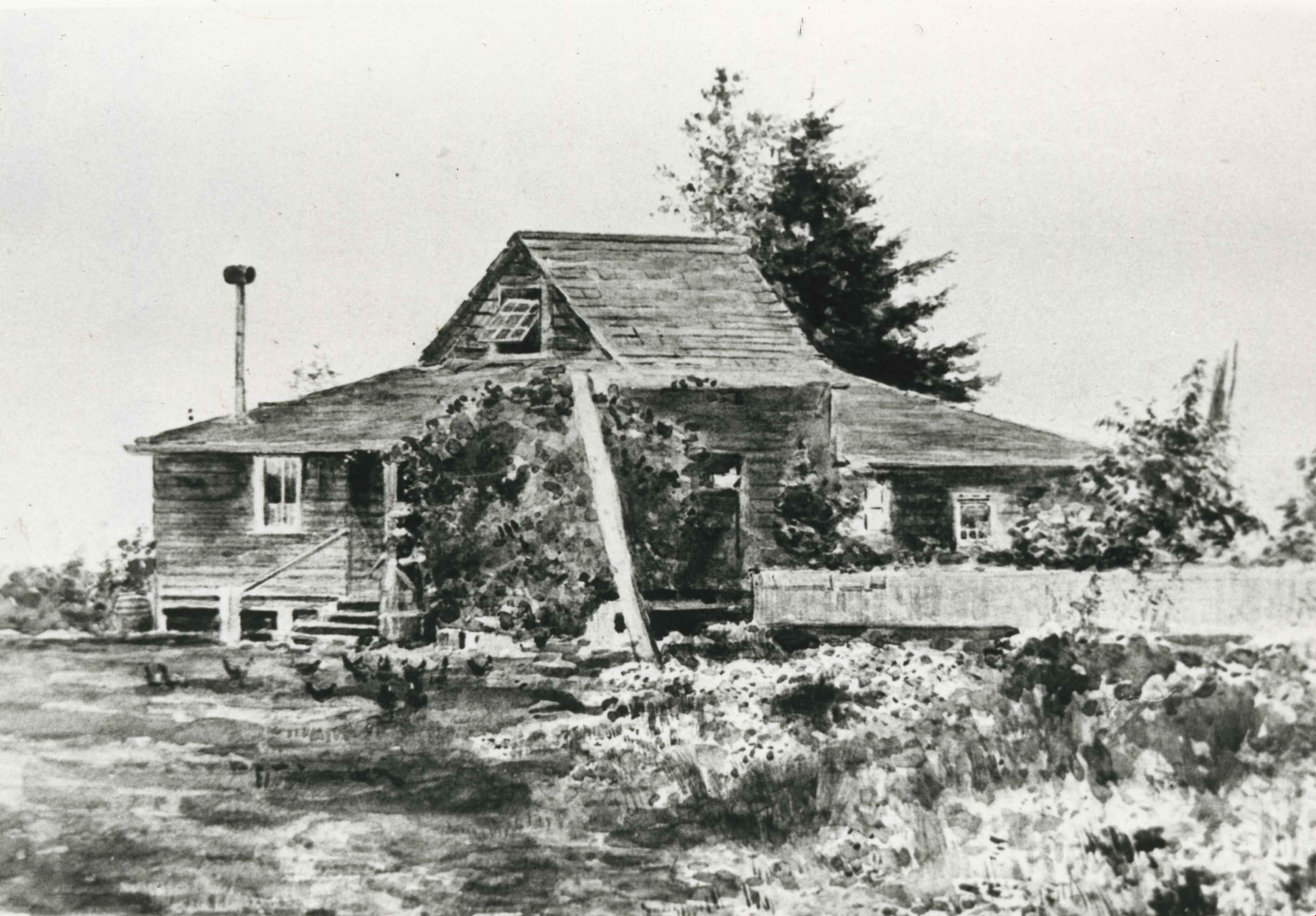
- Photograph of a 1908 watercolour of the original Patterson homestead built in 1894 on Patterson Trail, now Patterson Avenue. A woman feeding chickens can be seen by the front steps.
- Repository
- City of Burnaby Archives
- Date
- 1908 (date of original), copied 1986
- Collection/Fonds
- Burnaby Historical Society fonds
- Subseries
- Pioneer Tales subseries
- Physical Description
- 1 photograph : b&w ; 12.7 x 17.8 cm print
- Description Level
- Item
- Record No.
- 204-065
- Access Restriction
- No restrictions
- Reproduction Restriction
- No known restrictions
- Accession Number
- BHS1988-03
- Scope and Content
- Photograph of a 1908 watercolour of the original Patterson homestead built in 1894 on Patterson Trail, now Patterson Avenue. A woman feeding chickens can be seen by the front steps.
- Subjects
- Arts - Paintings
- Media Type
- Photograph
- Notes
- Title based on contents of photograph
- Geographic Access
- Patterson Avenue
- Historic Neighbourhood
- Central Park (Historic Neighbourhood)
Images
![Phillips-Hoyt Lumber Company, [1905] (date of original), copied 1992 thumbnail](/media/hpo/_Data/_Archives_Images/_Unrestricted/315/315-070.jpg?width=280)
Phillips-Hoyt Lumber Company
https://search.heritageburnaby.ca/link/archivedescription36715
- Repository
- City of Burnaby Archives
- Date
- [1905] (date of original), copied 1992
- Collection/Fonds
- Burnaby Historical Society fonds
- Description Level
- Item
- Physical Description
- 1 photograph : b&w ; 8.3 x 12.0 cm print
- Scope and Content
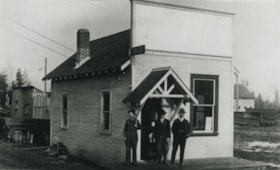
- Photograph of the exterior of the building housing the Phillips, Hoyt Lumber Co. office with three men standing outside. The building was located at 2730 McKay Avenue (old street numbering system) and the site is now a part of the Burnaby Public Library site.
- Repository
- City of Burnaby Archives
- Date
- [1905] (date of original), copied 1992
- Collection/Fonds
- Burnaby Historical Society fonds
- Subseries
- Burnaby Centennial Anthology subseries
- Physical Description
- 1 photograph : b&w ; 8.3 x 12.0 cm print
- Description Level
- Item
- Record No.
- 315-070
- Access Restriction
- No restrictions
- Reproduction Restriction
- No known restrictions
- Accession Number
- BHS1994-04
- Scope and Content
- Photograph of the exterior of the building housing the Phillips, Hoyt Lumber Co. office with three men standing outside. The building was located at 2730 McKay Avenue (old street numbering system) and the site is now a part of the Burnaby Public Library site.
- Subjects
- Buildings - Commercial
- Media Type
- Photograph
- Notes
- Title based on contents of photograph
- Geographic Access
- Willingdon Avenue
- Street Address
- 6100 Willingdon Avenue
- Historic Neighbourhood
- Central Park (Historic Neighbourhood)
- Planning Study Area
- Maywood Area
Images
![Phillips-Hoyt Lumber Company, [1905] (date of original), copied 1992 thumbnail](/media/hpo/_Data/_Archives_Images/_Unrestricted/315/315-070.jpg)
Phillips-Hoyt Lumber Company
https://search.heritageburnaby.ca/link/archivedescription36766
- Repository
- City of Burnaby Archives
- Date
- 1905 (date of original), copied 1992
- Collection/Fonds
- Burnaby Historical Society fonds
- Description Level
- Item
- Physical Description
- 1 photograph : b&w ; 7.9 x 12.5 cm print
- Scope and Content
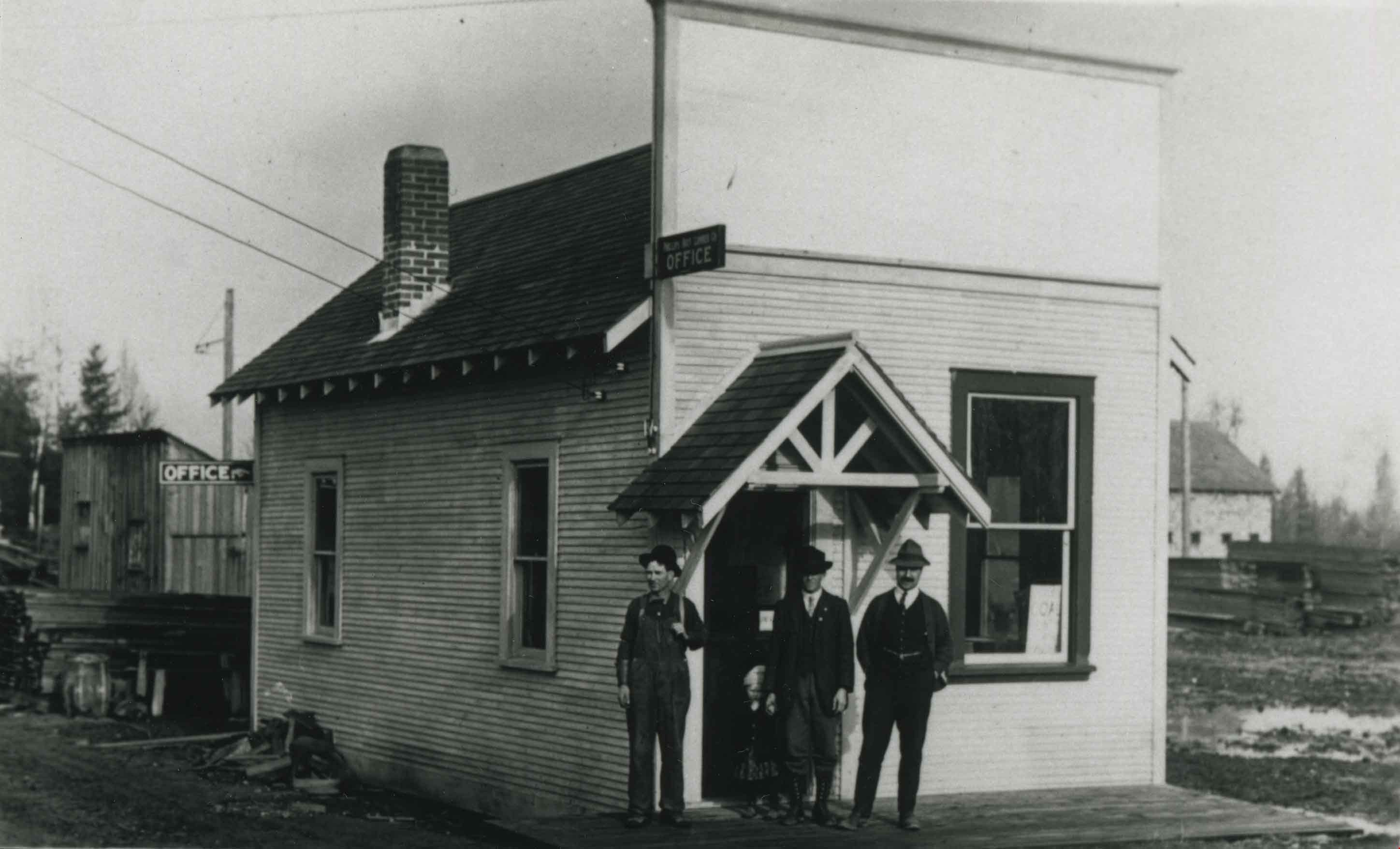
- Photograph of the exterior of the Phillips, Hoyt Lumber Co. on McKay Avenue with three men standing in front. This property is now part of the Burnaby Public Library site.
- Repository
- City of Burnaby Archives
- Date
- 1905 (date of original), copied 1992
- Collection/Fonds
- Burnaby Historical Society fonds
- Subseries
- Burnaby Centennial Anthology subseries
- Physical Description
- 1 photograph : b&w ; 7.9 x 12.5 cm print
- Description Level
- Item
- Record No.
- 315-121
- Access Restriction
- No restrictions
- Reproduction Restriction
- No known restrictions
- Accession Number
- BHS1994-04
- Scope and Content
- Photograph of the exterior of the Phillips, Hoyt Lumber Co. on McKay Avenue with three men standing in front. This property is now part of the Burnaby Public Library site.
- Subjects
- Buildings - Commercial
- Media Type
- Photograph
- Notes
- Title based on contents of photograph
- Geographic Access
- McKay Avenue
- Willingdon Avenue
- Street Address
- 6100 Willingdon Avenue
- Historic Neighbourhood
- Central Park (Historic Neighbourhood)
- Planning Study Area
- Maywood Area
Images
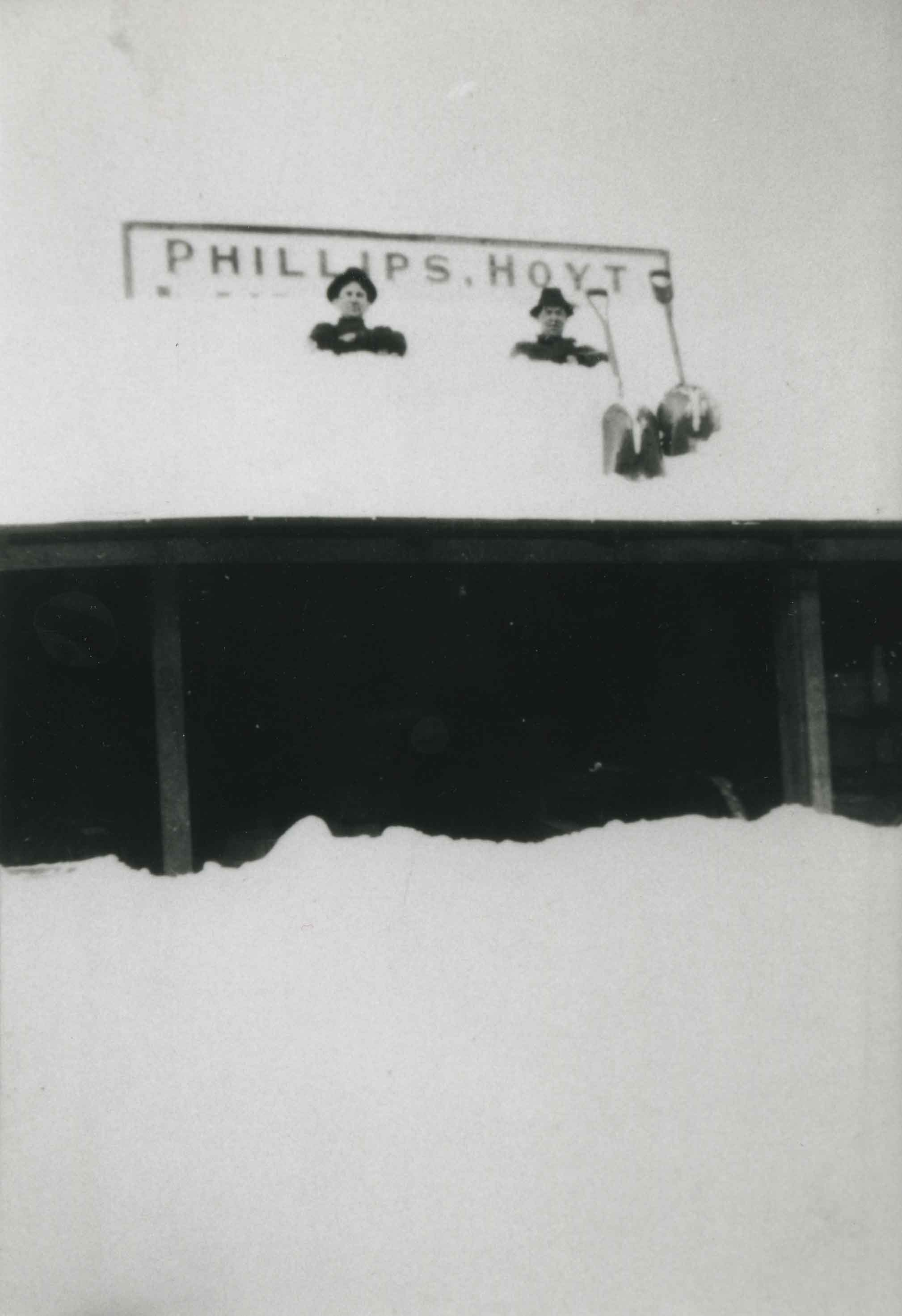
Phillips-Hoyt Lumber Company after snowfall
https://search.heritageburnaby.ca/link/archivedescription36769
- Repository
- City of Burnaby Archives
- Date
- 1905 (date of original), copied 1992
- Collection/Fonds
- Burnaby Historical Society fonds
- Description Level
- Item
- Physical Description
- 1 photograph : b&w ; 12.6 x 8.7 cm print
- Scope and Content
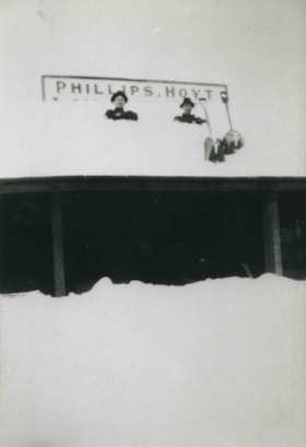
- Photograph of a building of the Phillips, Hoyt Lumber Co. after a snowfall. Two men are on the roof of the building with shovels.
- Repository
- City of Burnaby Archives
- Date
- 1905 (date of original), copied 1992
- Collection/Fonds
- Burnaby Historical Society fonds
- Subseries
- Burnaby Centennial Anthology subseries
- Physical Description
- 1 photograph : b&w ; 12.6 x 8.7 cm print
- Description Level
- Item
- Record No.
- 315-124
- Access Restriction
- No restrictions
- Reproduction Restriction
- No known restrictions
- Accession Number
- BHS1994-04
- Scope and Content
- Photograph of a building of the Phillips, Hoyt Lumber Co. after a snowfall. Two men are on the roof of the building with shovels.
- Subjects
- Buildings - Commercial
- Media Type
- Photograph
- Notes
- Title based on contents of photograph
- Geographic Access
- McKay Avenue
- Willingdon Avenue
- Street Address
- 6100 Willingdon Avenue
- Historic Neighbourhood
- Central Park (Historic Neighbourhood)
- Planning Study Area
- Maywood Area
Images
![Sambo's Pancake House, [196-] thumbnail](/media/hpo/_Data/_Archives_Images/_Unrestricted/126/201-001.jpg?width=280)
Sambo's Pancake House
https://search.heritageburnaby.ca/link/archivedescription35138
- Repository
- City of Burnaby Archives
- Date
- [196-]
- Collection/Fonds
- Burnaby Historical Society fonds
- Description Level
- Item
- Physical Description
- 1 photograph : col. postcard ; 8.9 x 14.0 cm
- Scope and Content
- Photographic postcard of the exterior and parking lot of Sambo's Pancake House, Kingsway. Printed on the top of the front of the postcard is "Sambo's Pancake House," and a sign on the building read's "Sambo's." Written on the back of the postcard: "Please surrender this card for 10% discount on you…
- Repository
- City of Burnaby Archives
- Date
- [196-]
- Collection/Fonds
- Burnaby Historical Society fonds
- Subseries
- Photographs subseries
- Physical Description
- 1 photograph : col. postcard ; 8.9 x 14.0 cm
- Description Level
- Item
- Record No.
- 201-001
- Access Restriction
- No restrictions
- Reproduction Restriction
- Reproduce for fair dealing purposes only
- Accession Number
- BHS1987-10
- Scope and Content
- Photographic postcard of the exterior and parking lot of Sambo's Pancake House, Kingsway. Printed on the top of the front of the postcard is "Sambo's Pancake House," and a sign on the building read's "Sambo's." Written on the back of the postcard: "Please surrender this card for 10% discount on your next visit to Sambo's, 5550 Kingsway, Burnaby. Offer good until Feb. 28th, 1969. Your host Sambo's."
- Subjects
- Geographic Features - Automobile Parking Lots
- Documentary Artifacts - Postcards
- Buildings - Commercial - Restaurants
- Names
- Sambo's Pancake House
- Media Type
- Photograph
- Notes
- Title based on contents of photograph
- Geographic Access
- Kingsway
- Street Address
- 5550 Kingsway
- Historic Neighbourhood
- Central Park (Historic Neighbourhood)
- Planning Study Area
- Windsor Area
Images
![Sambo's Pancake House, [196-] thumbnail](/media/hpo/_Data/_Archives_Images/_Unrestricted/126/201-001.jpg)
![Sanderson family home, [between 1950 and 1969] thumbnail](/media/hpo/_Data/_Archives_Images/_Unrestricted/513/521-022.jpg?width=280)
Sanderson family home
https://search.heritageburnaby.ca/link/archivedescription65790
- Repository
- City of Burnaby Archives
- Date
- [between 1950 and 1969]
- Collection/Fonds
- Field family fonds
- Description Level
- Item
- Physical Description
- 1 photograph (tiff) ; 600 ppi
- Scope and Content
- Photograph of the Sanderson family home (believed to be located at 3812/5457 Inman Avenue, one block north of Central Park). A larger house which still stands on this property replaced this house in 1921.
- Repository
- City of Burnaby Archives
- Date
- [between 1950 and 1969]
- Collection/Fonds
- Field family fonds
- Physical Description
- 1 photograph (tiff) ; 600 ppi
- Material Details
- Item is a scan of a b&w photograph
- Description Level
- Item
- Record No.
- 521-022
- Access Restriction
- No restrictions
- Reproduction Restriction
- Reproduce for fair dealing purposes only
- Accession Number
- 2010-14
- Scope and Content
- Photograph of the Sanderson family home (believed to be located at 3812/5457 Inman Avenue, one block north of Central Park). A larger house which still stands on this property replaced this house in 1921.
- Subjects
- Buildings - Residential - Houses
- Media Type
- Photograph
- Notes
- Title based on contents of photograph
- Geographic Access
- Inman Avenue
- Historic Neighbourhood
- Central Park (Historic Neighbourhood)
- Planning Study Area
- Maywood Area
Images
![Sanderson family home, [between 1950 and 1969] thumbnail](/media/hpo/_Data/_Archives_Images/_Unrestricted/513/521-022.jpg)
![Smith family home, [1960] (date of original), copied 1986 thumbnail](/media/hpo/_Data/_Archives_Images/_Unrestricted/204/204-310.jpg?width=280)
Smith family home
https://search.heritageburnaby.ca/link/archivedescription35452
- Repository
- City of Burnaby Archives
- Date
- [1960] (date of original), copied 1986
- Collection/Fonds
- Burnaby Historical Society fonds
- Description Level
- Item
- Physical Description
- 1 photograph : b&w ; 12.7 x 17.8 cm print
- Scope and Content
- Photograph of the Smith family home at 6186 Royal Oak Road. Although this photograph was taken in the 1960s, this was one of the first houses built on Royal Oak, in 1907. This was the home of James Smith and his wife, Agnes Smith (nee Taylor). They had four children: Grace Smith (later Grace Pletc…
- Repository
- City of Burnaby Archives
- Date
- [1960] (date of original), copied 1986
- Collection/Fonds
- Burnaby Historical Society fonds
- Subseries
- Pioneer Tales subseries
- Physical Description
- 1 photograph : b&w ; 12.7 x 17.8 cm print
- Description Level
- Item
- Record No.
- 204-310
- Access Restriction
- No restrictions
- Reproduction Restriction
- Reproduce for fair dealing purposes only
- Accession Number
- BHS1988-03
- Scope and Content
- Photograph of the Smith family home at 6186 Royal Oak Road. Although this photograph was taken in the 1960s, this was one of the first houses built on Royal Oak, in 1907. This was the home of James Smith and his wife, Agnes Smith (nee Taylor). They had four children: Grace Smith (later Grace Pletcher), Bob Smith, Warden Smith, and Ada Smith. It was a BC Mill Timber and Trading Co. prefabricated house originally built in BC and shipped to this site.
- Subjects
- Buildings - Residential - Houses
- Media Type
- Photograph
- Notes
- Title based on contents of photograph
- Geographic Access
- Royal Oak Avenue
- Street Address
- 6186 Royal Oak Avenue
- Historic Neighbourhood
- Central Park (Historic Neighbourhood)
- Planning Study Area
- Windsor Area
Images
![Smith family home, [1960] (date of original), copied 1986 thumbnail](/media/hpo/_Data/_Archives_Images/_Unrestricted/204/204-310.jpg)
Tidball-Cram family home
https://search.heritageburnaby.ca/link/archivedescription35605
- Repository
- City of Burnaby Archives
- Date
- 1908 (date of original), copied 1986
- Collection/Fonds
- Burnaby Historical Society fonds
- Description Level
- Item
- Physical Description
- 1 photograph : b&w ; 12.7 x 17.8 cm print
- Scope and Content
- Photograph of the Tidball-Cram family home, 3267Kingsway (later renumbered 5489 Kingsway) at Denbigh Avenue (Denbigh did not exist at the time; the area was the family's orchard). Grandfather Tidball (left) and Grandmother Tidball (right) are on the porch. The Tidball's daughter and son-in-law, Ali…
- Repository
- City of Burnaby Archives
- Date
- 1908 (date of original), copied 1986
- Collection/Fonds
- Burnaby Historical Society fonds
- Subseries
- Pioneer Tales subseries
- Physical Description
- 1 photograph : b&w ; 12.7 x 17.8 cm print
- Description Level
- Item
- Record No.
- 204-463
- Access Restriction
- No restrictions
- Reproduction Restriction
- No known restrictions
- Accession Number
- BHS1988-03
- Scope and Content
- Photograph of the Tidball-Cram family home, 3267Kingsway (later renumbered 5489 Kingsway) at Denbigh Avenue (Denbigh did not exist at the time; the area was the family's orchard). Grandfather Tidball (left) and Grandmother Tidball (right) are on the porch. The Tidball's daughter and son-in-law, Alice and William Cram, and their family joined the Tidballs on their farm after moving to Burnaby from the United States. The Crams and Tidballs produced and sold fruit, produce, honey, and cottage cheese.
- Subjects
- Buildings - Residential - Houses
- Media Type
- Photograph
- Notes
- Title based on contents of photograph
- Geographic Access
- Kingsway
- Street Address
- 5489 Kingsway
- Historic Neighbourhood
- Central Park (Historic Neighbourhood)
- Planning Study Area
- Windsor Area
Images


Topping a tree near Central Park
https://search.heritageburnaby.ca/link/archivedescription37280
- Repository
- City of Burnaby Archives
- Date
- 1904
- Collection/Fonds
- Burnaby Historical Society fonds
- Description Level
- Item
- Physical Description
- 1 photograph : sepia toned ; 21 x 26.5 cm
- Scope and Content
- Photograph of a man "topping" a large tree in the area near Central Park and Boundary Road.
- Repository
- City of Burnaby Archives
- Date
- 1904
- Collection/Fonds
- Burnaby Historical Society fonds
- Subseries
- Norah Code subseries
- Physical Description
- 1 photograph : sepia toned ; 21 x 26.5 cm
- Description Level
- Item
- Record No.
- 345-001
- Access Restriction
- No restrictions
- Reproduction Restriction
- No known restrictions
- Accession Number
- BHS1997-05
- Scope and Content
- Photograph of a man "topping" a large tree in the area near Central Park and Boundary Road.
- Media Type
- Photograph
- Photographer
- Code, Norah
- Notes
- Title based on contents of photograph
- Photographs in this collection were taken and compiled by Norah Code, former editor of the "Burnaby Courier" newspaper during the course of her work for the newspaper. A note with the file indicates that the man in the tree may be Ms. Code's father but his name is not provided.
- Geographic Access
- Boundary Road
- Central Park
- Historic Neighbourhood
- Central Park (Historic Neighbourhood)
- Planning Study Area
- Maywood Area
Images

![Violet Gibbs, [between 1963 and 1967] (date of original), copied 1991 thumbnail](/media/hpo/_Data/_Archives_Images/_Unrestricted/370/370-395.jpg?width=280)
Violet Gibbs
https://search.heritageburnaby.ca/link/archivedescription37807
- Repository
- City of Burnaby Archives
- Date
- [between 1963 and 1967] (date of original), copied 1991
- Collection/Fonds
- Burnaby Historical Society fonds
- Description Level
- Item
- Physical Description
- 1 photograph : b&w ; 4.3 x 2.9 cm print on contact sheet 20.7 x 26.7 cm
- Scope and Content
- Photograph of (left to right) the daughter of Violet Gibbs, Violet Gibbs with a vegetable from the garden in her hand and Clara MacDonald in the garden at the back of 3424 Olive Avenue (later renumbered 5827 Olive Avenue).
- Repository
- City of Burnaby Archives
- Date
- [between 1963 and 1967] (date of original), copied 1991
- Collection/Fonds
- Burnaby Historical Society fonds
- Subseries
- Burnaby Image Bank subseries
- Physical Description
- 1 photograph : b&w ; 4.3 x 2.9 cm print on contact sheet 20.7 x 26.7 cm
- Description Level
- Item
- Record No.
- 370-395
- Access Restriction
- No restrictions
- Reproduction Restriction
- No restrictions
- Accession Number
- BHS1999-03
- Scope and Content
- Photograph of (left to right) the daughter of Violet Gibbs, Violet Gibbs with a vegetable from the garden in her hand and Clara MacDonald in the garden at the back of 3424 Olive Avenue (later renumbered 5827 Olive Avenue).
- Subjects
- Geographic Features - Gardens
- Media Type
- Photograph
- Notes
- Title based on contents of photograph
- 1 b&w copy negative accompanying
- Negative has a pink cast
- Geographic Access
- Olive Avenue
- Street Address
- 5827 Olive Avenue
- Historic Neighbourhood
- Central Park (Historic Neighbourhood)
- Planning Study Area
- Maywood Area
Images
![Violet Gibbs, [between 1963 and 1967] (date of original), copied 1991 thumbnail](/media/hpo/_Data/_Archives_Images/_Unrestricted/370/370-395.jpg)
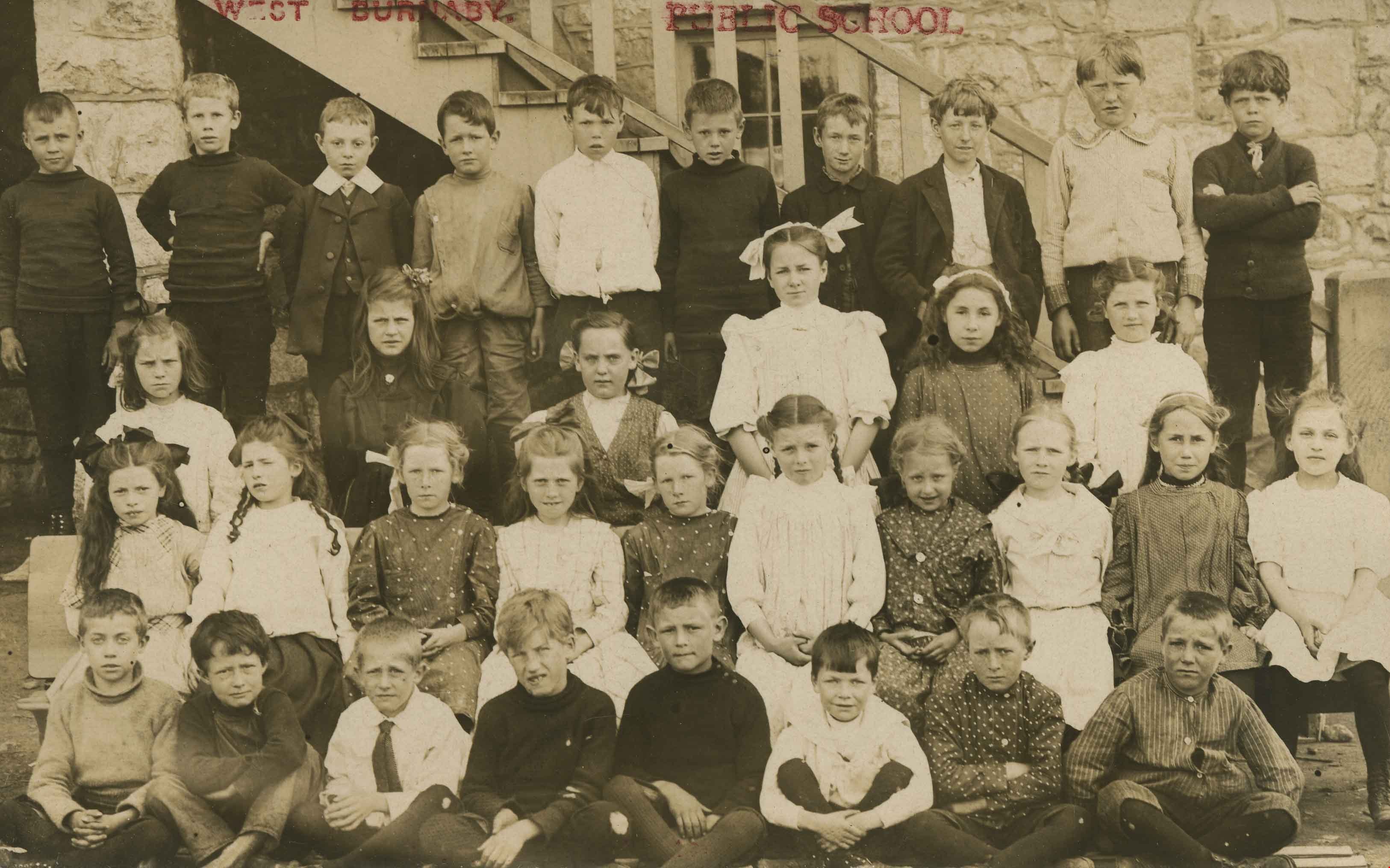
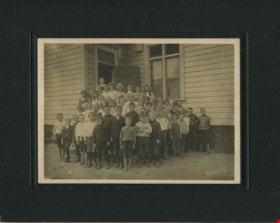
West Burnaby Public School
https://search.heritageburnaby.ca/link/archivedescription34521
- Repository
- City of Burnaby Archives
- Date
- 1907
- Collection/Fonds
- Burnaby Historical Society fonds
- Description Level
- Item
- Physical Description
- 1 photograph : sepia postcard ; 8.8 x 13.9 cm
- Scope and Content
- Photographic postcard of a West Burnaby School (later renamed Kingsway West School) class sitting and standing outside. The students are unidentified.
- Repository
- City of Burnaby Archives
- Date
- 1907
- Collection/Fonds
- Burnaby Historical Society fonds
- Subseries
- Elsie B. Wilson subseries
- Physical Description
- 1 photograph : sepia postcard ; 8.8 x 13.9 cm
- Description Level
- Item
- Record No.
- 034-003
- Access Restriction
- No restrictions
- Reproduction Restriction
- No known restrictions
- Accession Number
- BHS2007-04
- Scope and Content
- Photographic postcard of a West Burnaby School (later renamed Kingsway West School) class sitting and standing outside. The students are unidentified.
- Subjects
- Documentary Artifacts - Postcards
- Names
- Kingsway West School
- Media Type
- Photograph
- Notes
- Title based on contents of photograph
- Stamped across the top of the photograph, "West Burnaby / Public School"
- Geographic Access
- Kingsway
- Street Address
- 4800 Kingsway
- Historic Neighbourhood
- Central Park (Historic Neighbourhood)
- Planning Study Area
- Maywood Area
Images
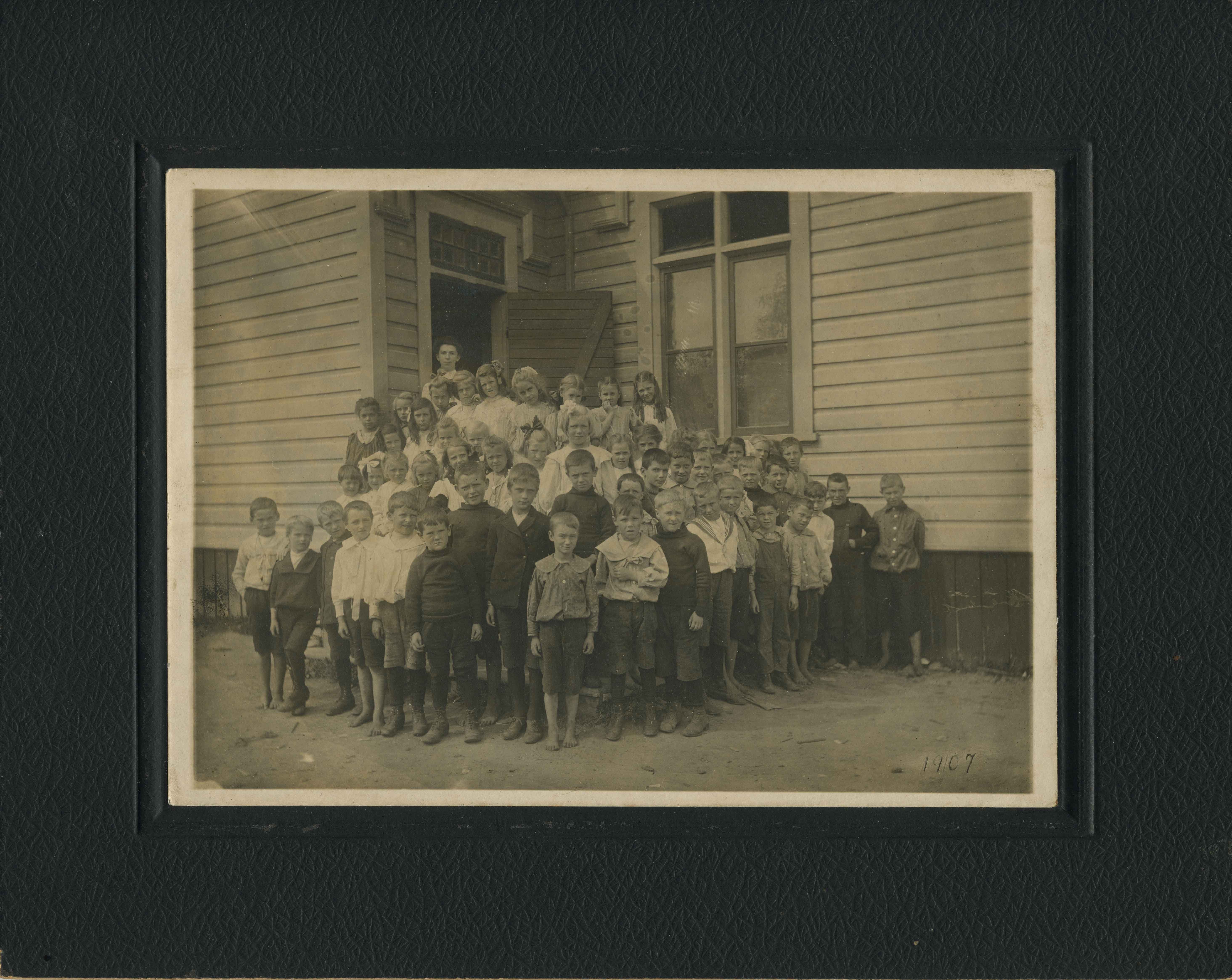
West Burnaby School Class
https://search.heritageburnaby.ca/link/archivedescription34519
- Repository
- City of Burnaby Archives
- Date
- 1904
- Collection/Fonds
- Burnaby Historical Society fonds
- Description Level
- Item
- Physical Description
- 1 photograph : b&w ; 12.8 x 17.8 cm mounted on cardboard 20.0 x 25.0 cm
- Scope and Content
- Photograph of a West Burnaby School (later renamed Kingsway West School) class standing outside of the school. Identified, back row, left to right: [unidentified], Georgina Bell, [first name unknown] Creamer, Gladys Bisset, Bernadette McNeil, Elsie Wilson, and Mabel Rowlinson. 2nd row, 5th from le…
- Repository
- City of Burnaby Archives
- Date
- 1904
- Collection/Fonds
- Burnaby Historical Society fonds
- Subseries
- Elsie B. Wilson subseries
- Physical Description
- 1 photograph : b&w ; 12.8 x 17.8 cm mounted on cardboard 20.0 x 25.0 cm
- Description Level
- Item
- Record No.
- 034-001
- Access Restriction
- No restrictions
- Reproduction Restriction
- No known restrictions
- Accession Number
- BHS2007-04
- Scope and Content
- Photograph of a West Burnaby School (later renamed Kingsway West School) class standing outside of the school. Identified, back row, left to right: [unidentified], Georgina Bell, [first name unknown] Creamer, Gladys Bisset, Bernadette McNeil, Elsie Wilson, and Mabel Rowlinson. 2nd row, 5th from left: Edith Marten. 3rd row, left to right: [first name unknown] McMaster, [unidentified], Jean Ross, [unidentified], Goldie Ralph, Mabel Ralph, Grace Marten, [3 unidentified children], Lois Rumble (later Wilson), [unidentified], and George Robertson. From row, left to right, starting at 7th child: Wilson Bailey, [first name unknown] Bond, [2 unidentified children], Bill Smith, Elgin Robertson, [2 unidentified children], Gordon Bailey, [2 unidentified children], [first name unknown] Bramble. The teacher, standing at the back left, is Miss Annie Theresa Forrest.
- Subjects
- Occupations - Teachers
- Names
- Bailey, Gordon
- Bailey, Wilson
- Bell, Georgina
- Bisset, Gladys
- Forrest, Annie Theresa
- Marten, Edith
- Marten, Grace
- McNeil, Bernadette
- Ralph, Mabel
- Robertson, Elgin
- Robertson, George
- Ross, Jean
- Rowlinson, Mabel
- Wilson, Lois Rumble
- Smith, Bill
- Kingsway West School
- Wilson, Elsie
- Media Type
- Photograph
- Notes
- Title based on contents of photograph
- Geographic Access
- Kingsway
- Street Address
- 4800 Kingsway
- Historic Neighbourhood
- Central Park (Historic Neighbourhood)
- Planning Study Area
- Maywood Area
Images
![Wilson family home, [190-] (date of original), copied 1986 thumbnail](/media/hpo/_Data/_Archives_Images/_Unrestricted/204/204-641.jpg?width=280)
Wilson family home
https://search.heritageburnaby.ca/link/archivedescription35783
- Repository
- City of Burnaby Archives
- Date
- [190-] (date of original), copied 1986
- Collection/Fonds
- Burnaby Historical Society fonds
- Description Level
- Item
- Physical Description
- 1 photograph : b&w ; 12.7 x 17.8 cm print
- Scope and Content
- Photograph of the Wilson family home on Westminster Road (now 4330 Kingsway) and Wilson Avenue (named after the family) near Central Park. Left to right: unidentified friend, Mrs. Annie Walmsley Wilson (mother), Annie Walmsley (half-sister, born to Annie Wilson and first husband, Samuel Walmsley),…
- Repository
- City of Burnaby Archives
- Date
- [190-] (date of original), copied 1986
- Collection/Fonds
- Burnaby Historical Society fonds
- Subseries
- Pioneer Tales subseries
- Physical Description
- 1 photograph : b&w ; 12.7 x 17.8 cm print
- Description Level
- Item
- Record No.
- 204-641
- Access Restriction
- No restrictions
- Reproduction Restriction
- No restrictions
- Accession Number
- BHS1988-03
- Scope and Content
- Photograph of the Wilson family home on Westminster Road (now 4330 Kingsway) and Wilson Avenue (named after the family) near Central Park. Left to right: unidentified friend, Mrs. Annie Walmsley Wilson (mother), Annie Walmsley (half-sister, born to Annie Wilson and first husband, Samuel Walmsley), and Elsie Wilson (half-sister).
- Subjects
- Buildings - Residential - Houses
- Media Type
- Photograph
- Notes
- Title based on contents of photograph
- Geographic Access
- Westminster Avenue
- Kingsway
- Street Address
- 4330 Kingsway
- Historic Neighbourhood
- Central Park (Historic Neighbourhood)
- Planning Study Area
- Maywood Area
Images
![Wilson family home, [190-] (date of original), copied 1986 thumbnail](/media/hpo/_Data/_Archives_Images/_Unrestricted/204/204-641.jpg)