Narrow Results By
Subject
- Accidents - Automobile Accidents 1
- Advertising Medium 2
- Advertising Medium - Signs and Signboards 1
- Aerial Photographs 1
- Buildings - Commercial - General Stores 1
- Buildings - Commercial - Hotels and Motels 1
- Buildings - Commercial - Restaurants 1
- Buildings - Commercial - Train Stations 1
- Buildings - Industrial 2
- Buildings - Industrial - Factories 1
- Buildings - Industrial - Powerhouses 5
- Buildings - Religious - Temples 1
Creator
- Alymer-Small, Sidney 1
- Artray Limited 5
- Atkinson, Dorothy Mallett 1
- Bancroft, Rose 1
- Bergson, George 9
- British Columbia Electric Company 1
- Burnaby Village Museum 2
- Burtch, Alvin 1
- Commercial Illustrators Industrial Photographers 1
- Croton Studio Limited 1
- Deforest, John Albert 1
- Draper, William Nelson 1
Person / Organization
- Beatty, Ella 1
- Bradbury, Dr. Bettina 2
- British Columbia Electric Railway Company 94
- British Columbia Hydro and Power Authority 1
- British Columbia Mills Timber and Trading Company 1
- Brown, Donald N. "Don" 1
- Burnaby Historical Society 1
- Burnham, Edward Lewis "Ted" 1
- Burtch, Alvin 1
- Clarke, Ellen 1
- Clarke, Joseph 1
- Conolly, Bud 1

Broadview Neighbourhood
https://search.heritageburnaby.ca/link/landmark750
- Repository
- Burnaby Heritage Planning
- Associated Dates
- 1905-1924
- Heritage Value
- Between 1905 and 1924, the Broadview neighbourhood in Burnaby was settled by almost 100 families who saw the advantage of living in an area that was served by two railway lines - the B.C. Electric Railway and the Great Northern Railway. Touted as being only a 20 minute car ride to the city centre, this neighbourhood expanded during the early 1920s with the promise of a new direct access road to the city being built by the Great Northern Railway company and new blocks being opened up on two government reserves adjoining it.
- Historic Neighbourhood
- Broadview (Historic Neighbourhood)
- Planning Study Area
- Cascade-Schou Area
Images


Central Park Neighbourhood
https://search.heritageburnaby.ca/link/landmark723
- Repository
- Burnaby Heritage Planning
- Associated Dates
- 1891-1904
- Heritage Value
- Central Park was one of the first and fastest-growing communities in Burnaby. Located along the electric tram line and the Vancouver Road (Kingsway), it was also chosen for a government settlement project referred to as the Central Park Small Holdings. The lands held by the Provincial Government were subdivided and sold around 1894 and by 1899 the settlement was large enough to warrant the construction of an Anglican Church there.
- Historic Neighbourhood
- Central Park (Historic Neighbourhood)
- Planning Study Area
- Maywood Area
Images


Joseph Clarke House
https://search.heritageburnaby.ca/link/landmark505
- Repository
- Burnaby Heritage Planning
- Description
- The Joseph Clarke House is a two and one-half storey, wood-frame house, with shingle siding, a front-gabled roof and a full open front verandah. It is located on Jersey Avenue within the Central Park neighbourhood of Burnaby.
- Associated Dates
- 1909
- Formal Recognition
- Heritage Designation, Community Heritage Register
- Other Names
- Joseph & Ellen Clarke House, Clarke Residence
- Street View URL
- Google Maps Street View
- Repository
- Burnaby Heritage Planning
- Other Names
- Joseph & Ellen Clarke House, Clarke Residence
- Geographic Access
- Jersey Avenue
- Sandell Street
- Associated Dates
- 1909
- Formal Recognition
- Heritage Designation, Community Heritage Register
- Enactment Type
- By-law No. 11930
- Enactment Date
- 29/08/2005
- Description
- The Joseph Clarke House is a two and one-half storey, wood-frame house, with shingle siding, a front-gabled roof and a full open front verandah. It is located on Jersey Avenue within the Central Park neighbourhood of Burnaby.
- Heritage Value
- Built circa 1909 for Central Park farmer Joseph Clarke (1851-1936) and his wife, Ellen (1864-1938), this Edwardian-era farm house is valued for its vernacular design, which demonstrates the utilitarian nature of working-class housing during the boom years prior to the First World War. The Joseph Clarke House is additionally valued for its link with the development of the Central Park neighbourhood during the Edwardian era. The advent of the Central Park interurban rail line in 1892, operated by the B.C. Electric Company, connected the area to Vancouver and led to its suburban development. This is one of the oldest surviving houses in the Central Park neighbourhood. It was designated as a municipal heritage site in 2005 and rehabilitated as part of the adjacent multi-family townhouse and apartment redevelopment.
- Defining Elements
- Key elements that define the heritage character of the Joseph Clarke House include its: - location on Jersey Avenue in the Central Park neighbourhood - residential form, scale and massing as expressed by its two and one-half storey height with rectangular plan, front bay window and front-gabled roof - wood-frame construction - Edwardian era detailing such as the open front verandah, asymmetrical front entrance, glazed front door with sidelights and triangular eave brackets
- Historic Neighbourhood
- Central Park (Historic Neighbourhood)
- Planning Study Area
- Garden Village Area
- Function
- Primary Historic--Single Dwelling
- Primary Current--Single Dwelling
- Community
- Burnaby
- Cadastral Identifier
- P.I.D. 027-101-428
- Boundaries
- The Joseph Clarke House is comprised of a single residential lot located at 5575 Jersey Avenue, Burnaby.
- Area
- 2370
- Contributing Resource
- Building
- Ownership
- Private
- Documentation
- City of Burnaby Planning and Building Department, Heritage Site Files
- Names
- Clarke, Joseph
- Clarke, Ellen
- Street Address
- 5575 Jersey Avenue
- Street View URL
- Google Maps Street View
Images


O.G. Naud House
https://search.heritageburnaby.ca/link/landmark509
- Repository
- Burnaby Heritage Planning
- Description
- The O.G. Naud House is a south facing, two-storey house with a bellcast hipped roof, set on a high basement. It features a double-height front verandah supported by classical columns. It is located on Victory Street in the Alta Vista neighbourhood of South Burnaby, and is one of the oldest houses i…
- Associated Dates
- 1908
- Formal Recognition
- Heritage Designation, Community Heritage Register
- Other Names
- Onezime & Charlsie Naud House
- Street View URL
- Google Maps Street View
- Repository
- Burnaby Heritage Planning
- Other Names
- Onezime & Charlsie Naud House
- Geographic Access
- Victory Street
- Associated Dates
- 1908
- Formal Recognition
- Heritage Designation, Community Heritage Register
- Enactment Type
- By-law No. 12316
- Enactment Date
- 26/05/2008
- Description
- The O.G. Naud House is a south facing, two-storey house with a bellcast hipped roof, set on a high basement. It features a double-height front verandah supported by classical columns. It is located on Victory Street in the Alta Vista neighbourhood of South Burnaby, and is one of the oldest houses in the area.
- Heritage Value
- Built in 1908, the O.G. Naud House is valued as one of the first houses to be built in the Alta Vista neighbourhood and is a direct link to the first settlement of the area. Close proximity to the B.C. Electric Railway streetcar line, at Royal Oak and Highland Park, permitted easy access to New Westminster and Vancouver. These transportation links, combined with spectacular views of the Fraser Valley, encouraged the early development of this South Burnaby neighbourhood. The O.G. Naud House is architecturally significant as an example of the influence of the Classical Revival style that had been popularized in Eastern Canada. The basic form of the house is a Foursquare, with a double-height verandah that dominates the symmetrically balanced façade, supported on lathe-turned columns. A central entry and regular fenestration further unify the façade composition. Construction employed locally available materials. The rough-cut foundation stone was harvested from boulders from the G. Ledingham property on the south side of Victory Street. The builder and first owner, Onezime George Naud (1858-1951), was originally from St. Albans, Quebec. He worked on railway construction in Alabama, where he met his wife, Charlsie Elizabeth Sims (1869-1974). He later took part in the 1898 Gold Rush in Atlin, then worked as a stonemason on CPR culverts and bridges across B.C. An accomplished stonemason, Naud also worked on the original Vancouver and New Westminster post offices, the Parliament buildings in Victoria, and the Capitol building in Olympia, Washington.
- Defining Elements
- The key characteristics that define the heritage character of the O.G. Naud House include its: - south-facing location, with generous set back from the street, in the Alta Vista neighbourhood of South Burnaby - residential form, scale and massing as expressed by its two-storey height plus full basement, bellcast hipped roof, rectangular plan and front projecting double-height verandah - masonry construction materials such as the rough-cut granite foundation - wood-frame construction, including lapped wooden siding and shingle siding extant under later cladding - Edwardian era features including lathe-turned columns, balustrades of dimensional lumber, scroll-cut bargeboards in front gable, and scroll-cut eave brackets - associated landscape features including lane access to the east, large cedar trees and perimeter plantings
- Historic Neighbourhood
- Alta Vista (Historic Neighbourhood)
- Planning Study Area
- Sussex-Nelson Area
- Function
- Primary Historic--Single Dwelling
- Community
- Alta Vista
- Cadastral Identifier
- P.I.D.003-100-375
- Boundaries
- The O.G. Naud House is comprised of a single residential lot located at 4737 Victory Street, Burnaby.
- Area
- 1099.47
- Contributing Resource
- Building
- Ownership
- Private
- Documentation
- City of Burnaby Planning and Building Department, Heritage Site Files
- Street Address
- 4737 Victory Street
- Street View URL
- Google Maps Street View
Images


Sperling Avenue (Pole Line Road)
https://search.heritageburnaby.ca/link/landmark761
- Repository
- Burnaby Heritage Planning
- Associated Dates
- 1905
- Heritage Value
- The road currently known as Sperling Avenue was originally the "Pole Line Road" - so named because it served as the route for a power transmission line to connect the Buntzen Lake Power Plant to the Burnaby sub-station at Griffiths Avenue in 1905. It was named after Rochfort Henry Sperling, the Superintendant of the B.C.E.R. Company. The B.C. Electric Railway contracted Herbert Gilley to open the Pole Line Road from Hastings to Johnston Road, as Gilley Brothers were already actively logging the area.
- Historic Neighbourhood
- Burnaby Lake (Historic Neighbourhood)
- Planning Study Area
- Sperling-Broadway Area
- Lochdale Area
- Ardingley-Sprott Area
- Morley-Buckingham Area
Images


St. John the Divine Anglican Church
https://search.heritageburnaby.ca/link/landmark514
- Repository
- Burnaby Heritage Planning
- Description
- St. John the Divine Anglican Church is a landmark wood-frame Gothic Revival church, with Gothic windows and spire. It is located on Kingsway, one of Burnaby’s main commercial thoroughfares, near the SkyTrain transit line and across the street from Central Park.
- Associated Dates
- 1905
- Formal Recognition
- Community Heritage Register
- Street View URL
- Google Maps Street View
- Repository
- Burnaby Heritage Planning
- Geographic Access
- Kingsway
- Associated Dates
- 1905
- Formal Recognition
- Community Heritage Register
- Enactment Type
- Council Resolution
- Enactment Date
- 09/06/2003
- Description
- St. John the Divine Anglican Church is a landmark wood-frame Gothic Revival church, with Gothic windows and spire. It is located on Kingsway, one of Burnaby’s main commercial thoroughfares, near the SkyTrain transit line and across the street from Central Park.
- Heritage Value
- St. John the Divine Anglican Church is valued as a symbol of the traditions of early Burnaby pioneers and as the oldest surviving church building in the city. Established in 1899, St. John was the first church in the community and was located at a prominent intersection of the old Vancouver-Westminster Road (now Kingsway) and the British Columbia Electric Railway’s interurban station at Central Park. This prominent intersection of the road and rail developed as the town centre of the Central Park district. The first St. John church was destroyed by fire, and was rebuilt at the same location in 1904-05. This church is additionally significant for its association with prominent local architect Joseph Henry Bowman (1864-1943) who emigrated from England in 1888. Bowman was a member of the parish, and designed both the first church and its subsequent replacement. Bowman’s prolific career embraced many stylistic changes and technological advances, and this church is a surviving example of one of his rare religious commissions. The design of the new church's nave and vestry was based on the Gothic Revival style of Christ Church Anglican in Surrey, B.C., which had been the former church of St. John’s incumbent Rev. William Bell. Evolving over time as the congregation grew, the church received a number of early additions, and in 1953 was substantially renovated and enlarged through a new design by Vancouver architect Ross Lort. The original church nave was separated from the tower and turned to allow for a large addition. The congregation relocated to a new church in 1998, and at that time removed the church's memorial windows, leaving behind a number of the original art glass windows installed in the 1920s. The church building was renovated in 2004-05, and surviving original elements were retained and restored, including of the original church tower and interior chancel ceiling. A valued feature of the building is the original cast iron church bell that remains in the tower. It was purchased by the children of the congregation in 1912, and in 1924 was rededicated on Armistice Day as a memorial to Burnaby resident Lt. James Donald McRae Reid, who died in the First World War.
- Defining Elements
- Key elements that define the heritage character of St. John the Divine Anglican Church include its: - location on the north side of Kingsway, opposite Central Park - ecclesiastical form, scale and massing as expressed by the offset tower and tall, gabled roof - tower with its original horizontal wooden drop siding, bellcast square roof with octagonal drum above and bellcast octagonal spire - cedar shingle roof cladding - metal cross at peak of spire - Gothic Revival details such as: Gothic lancet windows with leaded stained glass panels; Gothic entrance door at the base of the tower; pointed-arch louvers in the tower; and exterior gable end scissor-trusses - interior features such as wooden scissor-trusses with diagonal fir tongue and groove panelling on the ceiling above, fir tongue-and-groove panelling on the wall of the nave, and original cedar and fir pews and altar rails - cast iron bell in tower
- Historic Neighbourhood
- Central Park (Historic Neighbourhood)
- Planning Study Area
- Garden Village Area
- Architect
- Joesph Henry Bowman
- Function
- Primary Historic--Place of Worship
- Primary Current--Place of Worship
- Community
- Burnaby
- Cadastral Identifier
- 003-398-871
- Boundaries
- St. John the Divine Anglican Church is comprised of a single institutional lot located at 3891 Kingway, Burnaby.
- Area
- 3486.66
- Contributing Resource
- Building
- Ownership
- Private
- Street Address
- 3891 Kingsway
- Street View URL
- Google Maps Street View
Images


The Art of Railroading
https://search.heritageburnaby.ca/link/museumlibrary7506
- Repository
- Burnaby Village Museum
- Author
- Alymer-Small, Sidney
- Publication Date
- 1908
- Call Number
- 385 ALY
- Repository
- Burnaby Village Museum
- Collection
- Special Collection
- Material Type
- Book
- Call Number
- 385 ALY
- Author
- Alymer-Small, Sidney
- Place of Publication
- Chicago, IL
- Publisher
- Railway Publications Society
- Publication Date
- 1908
- Printer
- Frederick J. Drake & Co.
- Physical Description
- 924 p. : ill. 6 cm thick
- Library Subject (LOC)
- Railroads--Design and construction
- Railroads
- Electric railroads
- Subjects
- Transportation
- Notes
- Electrical Railroading / Electricity as applied to railroad transportation
Dorothy's dream house
https://search.heritageburnaby.ca/link/museumlibrary7354
- Repository
- Burnaby Village Museum
- Collection
- Reference Collection
- Material Type
- Moving Images
- Call Number
- 333.3 BCH VR
- Contributor
- British Columbia Electric Company
- Place of Publication
- [British Columbia, Canada]
- Publisher
- BC Hydro
- Publication Date
- c1954-1955
- Physical Description
- 1 videodisc (30 min.) : sd., col ; 4 3/4 in.
- Library Subject (LOC)
- Construction--British Columbia
- House construction
- Household appliances
- Lions Gate Bridge (Vancouver, B.C.)--History
- Women---British Columbia--Social conditions--1945-
- Kitchens
- British Columbia Electric Company
- British Columbia--History
- Geographic Access
- Vancouver
- Notes
- Summary: Promotional film. The planning, design, construction and features of a BCE "Ease-of-Living" modern home, equipped with up-to-date electrical appliances. Footage of special interest includes a view from a car crossing Lion's Gate Bridge and views of the British Properties.
- Credit note: director: A.J.H. Pullinger; photography: Jack McCallum; photography: Denny Brearley; sound: Dave Pomeroy; sound: Telesound Film Recordings Ltd.; editor: Werner Franz; script: Robert Francis; art direction: Marguerite Roozeboom; sponsored/presented by: British Columbia Electric Company; producing agency/company: Lew Parry Film Productions
George Bergson fonds
https://search.heritageburnaby.ca/link/museumdescription19275
- Repository
- Burnaby Village Museum
- Date
- 1955-1995
- Collection/Fonds
- George Bergson fonds
- Description Level
- Fonds
- Physical Description
- 28 photographs : prints + slides + negatives
- Scope and Content
- Fonds consists of a selection of photographs taken by George Bergson that document interurban trams and the BCER, the construction of stage 4 at the Bridge Studios in Burnaby and views of Burnaby Village Museum.
- Repository
- Burnaby Village Museum
- Collection/Fonds
- George Bergson fonds
- Description Level
- Fonds
- Physical Description
- 28 photographs : prints + slides + negatives
- Scope and Content
- Fonds consists of a selection of photographs taken by George Bergson that document interurban trams and the BCER, the construction of stage 4 at the Bridge Studios in Burnaby and views of Burnaby Village Museum.
- History
- George Bergson became interested in photography after taking a photography course in high school and since then has created over 40,000 photographs. George's particular interest has been the BCER Interurban trams and rail transportation in British Columbia. In his eary years, George worked as a CNR electrical apprentice in Vancouver and before he retired in 1990, George worked as a maintenance supervisor at Bridge Studios. While working as a maintenance supervisor at Bridge Studios, he managed to get the siding off of the Great Northern Railway to Bridge Studios and after removing the ties and rails he donated them to the Sḵwx̱wú7mesh Railway Museum. Photographer, George Bergson and transportation historian, Henry Ewert, were the last people to take a ride on the BCER Interurban no.1203 on November 18, 1956. George has also donated hundreds of his photographs to the City of Vancouver Archives and the City of Coquitlam Archives.
- Creator
- Bergson, George
- Accession Code
- BV988.7
- BV019.46
- BV022.28
- Date
- 1955-1995
- Media Type
- Photograph
- Notes
- Title based on contents of fonds
Jesse Love farmhouse series
https://search.heritageburnaby.ca/link/museumdescription9782
- Repository
- Burnaby Village Museum
- Date
- [1893-1970] (date of originals), copied 1988-1998, predominant 1988-2000
- Collection/Fonds
- Burnaby Village Museum fonds
- Description Level
- Series
- Physical Description
- approx. 84 cm of textual records + approx. 1,910 photographs + approx. 100 architectural drawings + 3 audio cassettes + 1 videocassette
- Scope and Content
- Series consists of records involved in the purchase, moving, restoration, research, conservation and exhibiting of the Love family farmhouse by Burnaby Village Museum. Records have been arranged into the following subseries: 1) Love farmhouse conservation work files subseries 2) Love farmhouse re…
- Repository
- Burnaby Village Museum
- Collection/Fonds
- Burnaby Village Museum fonds
- Series
- Jesse Love farmhouse series
- Description Level
- Series
- Physical Description
- approx. 84 cm of textual records + approx. 1,910 photographs + approx. 100 architectural drawings + 3 audio cassettes + 1 videocassette
- Scope and Content
- Series consists of records involved in the purchase, moving, restoration, research, conservation and exhibiting of the Love family farmhouse by Burnaby Village Museum. Records have been arranged into the following subseries: 1) Love farmhouse conservation work files subseries 2) Love farmhouse restoration photographs subseries 3) Love farmhouse curatorial files subseries 4) Love farmouse research files subseries 5) Love family photographs 6) Love farmhouse Oral History subseries 7) Love farmhouse architectural drawings subseries
- History
- Jesse Love was born in Swindon, England in 1847 and left England to work on a dairy farm in the Toronto area. While working on the farm in Toronto, he met Martha Leonard who he married in 1879. Martha was born on February 3, 1858 in Bedfordshire, England and had come to Canada with her parents George and Ann Leonard. While living in Toronto, Jesse and Martha had two children, George born March 22, 1880 and Annie Elizabeth on August 24, 1881. About one year after Annie was born, the Love family moved to North Dakota to grow wheat. While living there, they had two more children, Henry who was born August 24, 1883 and Edith Minnie born October 9, 1885. The family decided to move further west after hearing about the fairer weather conditions from Martha’s father, George Leonard, who had settled in Vancouver in 1885. On May 23, 1887, Jesse, Martha and their four children arrived in Vancouver after travelling across Canada from Winnipeg on the first transcontinental train. The Loves made their home in Vancouver while Jesse helped clear land on Granville Street. Their fifth child, Thomas Robert was born on September 17, 1887 and soon after, the family moved to Lulu Island in Richmond where they lived growing vegetables and selling them to Vancouver hotels. While living and farming on Lulu island, the couple had two more girls, Martha (Dot or Dorothy) born on December 17, 1889 and Sarah Marie, born February 8, 1892. On October 6, 1893 an agreement was signed by Jesse Love to purchase 14.52 acres of land from Joseph C. Armstrong. The acreage covered the north east section of District Lot 25 within the newly incorporated District of the Municipality of Burnaby. It was here where the original Love house was built (between October 1893 and April 15, 1894) by Jesse Love with the help of local builder George Salt and father in law, George Leonard. The house consisted of an entrance hall, dining room, lean to kitchen, master bedroom and three bedrooms upstairs. A road was constructed and named Cumberland in 1905 and ran from District Lot 25 through to District Lot 11. The address for the Love home was 1390 Cumberland Road and in the early 1960’s the address was renumbered 7651 Cumberland Street. On the land surrounding the house, Jesse Love planted an orchard along with strawberries and raspberries which he sold at the Fraser Valley Market, T.S. Anandale’s Grocery Store in New Westminster and to hotels around Vancouver. Jesse Love served on the Burnaby School Board and also as a District Councillor in 1901 and from 1904-1907. While living in the house, Jesse and Martha had four more children, Phoebe Leonard, born April 15, 1894, Esther, born August 28, 1896, John Leonard, born June 7, 1899 and Hannah Victoria (also known as Girlie) who was born May 12, 1902. As the family grew to eleven children, additions along with some substantial remodelling in the craftsman style took place. In about 1898, a north wing addition was added to include a parlour with two windows, the construction of two more bedrooms and the relocation of the stair case to the North West wall. In 1903 the front door moved to the north elevation, a front porch was extended along the east wall and a summer lean to kitchen was added to the west elevation. Between 1905 and 1910, a tin embossed ceiling was installed along with an addition of the main kitchen which included a pantry, bathtub and a back porch. In about 1912, five craftsman style windows replaced the original pioneer tent style, the front verandah was enlarged to wrap around the south and east elevations, a back door was installed in the kitchen to access the verandah and wood shingle siding and brackets were added to the exterior. In 1918, at the age of 31 years, Robert Love fell ill due to an influenza epidemic and died on November 23, 1918. Following their son’s death, Martha Love became weak and on August 24, 1920, she passed away. By this time, Jesse had sold off a large percentage of his land and his youngest daughter, Girlie decided to stay on to live and care for him. Since the house was too large for just the two of them, Jesse invited any other children to return and share the residence. For a while his son, George and his wife joined them until 1925, followed by his daughter Sarah Parker (nee Love), her husband William and their three children, Albert, Bill and Elsie. The house remained pretty unchanged until 1928 after Jesse Love died of pneumonia (March 10, 1928) and the house was purchased by Sarah and her husband William Parker who continued to live there with their children. The master bedroom wall on the main floor opened up to the dining room, the kitchen pantry and bathtub converted to an alcove with a marble counter and enlarged window and sink while the bathroom was moved to the upstairs and the furnace and coolers were installed in the crawl space under the kitchen. A hot water tank was installed in the house in 1966. Sarah continued to live in the house until a little while after her husband William died in 1961. She sold the house to her daughter Elsie and husband John Hughes in 1966, who lived in the house along with their son Brent, until August 23, 1971. Mahbir Molchan Papan and his wife Geraldine Papan bought the house August 23, 1971 and by 1982, the house was sold to Nirmal Singh Singha and Narinder Singha. The Papans continued to rent the house from Nirmal Singh Singha and Narinder Singha until the late 1980s. In 1988, the house was scheduled for demolition with the remaining property to be subdivided. Fortunately, a neighbour, Mr. Harvey Elder recognized the farmhouse's historical significance and contacted the Burnaby Historical Society. Following this event, the owners agreed to donate the building to the Burnaby Village Museum (under the Century Park Museum Association) who financed the move of the house from Cumberland Street to the museum site. Heritage planner and architect, Robert Lemon provided guidance for the project. Prior to the move, the two porches were removed and demolished while the kitchen and roof were both separated from the main house. The kitchen and roof of the house were transported to Burnaby Village Museum on May 20, 1988 by Nickel Bros. House Moving company, while the main frame of the house completed its transportation to the museum near the end of May 1988 (due to low overhead wires). The house was moved down Cumberland Street to 10th Avenue, up Canada Way to Sperling and set on temporary footings near Hart House. Robert Lemon oversaw structural improvements such as, upgrading floor joists and creating new foundations to replace the original timber foundation of the farmhouse. The restoration went through several phases of work between 1988 until it opened in November 1998. Restoration began on both the interior and exterior features to be interpreted from the period of 1925. On November 23, 1992, the building was designated a heritage building under Heritage Designation Bylaw 1992, Bylaw Number 9807. In 1993, the architecture firm of Brian G. Hart Associates was appointed for the design and construction supervision of the restoration project. Plans were created for a foundation on the museum site in 1989 and the farmhouse was eventually settled on a permanent foundation behind the Burnaby Village Museum administration building in 1993 along with the reattachment of the roof. The kitchen section was reattached to the main house in 1994 along with skirting around the foundation and the reshingling of the exterior. In 1996, the tin ceiling was removed to make way for the installation of the internal electrical system along with sprinklers, ceiling heating and fire break gyprock. The dining room ceiling joists were consolidated, a pantry and bathroom were added to the kitchen, the downstairs bedroom wall was opened and filled, the dining and kitchen doorways were widened. In 1997, a wheelchair ramp was installed along with a concrete sidewalk, stair rails, cement pads at the base of the stairs and a gravel sink for any excess water. Interior work included painting of the kitchen, restoration and furnishing of the kitchen pantry, insulation of the house floor to protect from rodents along with the reconstruction of the kitchen and house chimneys. The registrar worked together with the curator and conservator and was tasked with a large research project on the house including the family contacts and family history, property information, plans, photographs, artifacts, furnishings, stories etc. all organized in files for easy retrieval. A great deal of research and conservation was undertaken in order to make the interior of the house authentic to the time period as possible. One of the biggest projects was selecting and obtaining wall coverings since much of the original wallpaper was incomplete and poor condition. The conservator and registrar were lucky enough to locate a few samples of the original paper and engage the Bradbury and Bradbury Art Wallpaper Company of Benica, California to reproduce replica designs for free. The City of Burnaby now has its own series “Burnaby Village Papers” produced by this company which are titled “Burnaby Wall”; “Burnaby Border” and “Burnaby Ceiling”. All three of these wallpaper designs have been used in the Love farm house and are also commercially available through the Bradbury and Bradbury Art Wallpaper Company. In 1997, restoration of the kitchen was completed and opened to the public. After the completion of the dining room, main floor bedroom and parlour, the Love farmhouse exhibit opened on November 29, 1998 with an open invitation to the public and extended members of the Love family. Officials including the Mayor, Doug Drummond and Love family members were all present to cut the ribbon for the special event.
- Accession Code
- BV018.41; BV020.5
- Access Restriction
- Restricted access
- Date
- [1893-1970] (date of originals), copied 1988-1998, predominant 1988-2000
- Arrangement
- The majority of the records within series and subseries were arranged by a staff members of Burnaby Village Museum who worked on the historical research and restoration of the house. Other photographs documenting the move and further restoration work were added later and included in the arrangment by format and subject.
- Notes
- Title based on content of series
- Jesse Love farmhouse is described as an Artifact under BV988.33.1
- Some records within this collection have restricted access and are subject to FIPPA
- Accessions BV018.41 and BV020.5 form this fonds
Riverway West School Parent-Teachers Association subseries
https://search.heritageburnaby.ca/link/archivedescription110
- Repository
- City of Burnaby Archives
- Date
- 1923-1967
- Collection/Fonds
- Burnaby Historical Society fonds
- Description Level
- Subseries
- Physical Description
- 1 scrapbook.
- Scope and Content
- Subseries consists of a Riverway West School PTA scrapbook and photographs.
- Repository
- City of Burnaby Archives
- Date
- 1923-1967
- Collection/Fonds
- Burnaby Historical Society fonds
- Physical Description
- 1 scrapbook.
- Description Level
- Subseries
- Accession Number
- BHS1992-03
- Scope and Content
- Subseries consists of a Riverway West School PTA scrapbook and photographs.
- History
- The original Riverway West School was a one room school house built in 1923 just west of the ravine at Sussex Avenue and Marine Drive. Miss Marion Swanson was the first teacher at the school ande Mr. Morrison its first custodian. Miss Carrie Kidd taught from 1924 to 1935, with the enrolment increasing from 18 in 1924 to 42 pupils in 1929, and including grades one to seven. In 1930 grades one to four were at Riverway while the older students went to Nelson. It continued on as a one-room school of four grades until 1952. As the school was seen by parents to be “greatly lacking” for students and teachers “in comfortable accommodations and vital equipment necessary for their extra curricular and recreational needs, such as were enjoyed by children in the larger schools” they formed a parent-teacher association in September 1951 to remedy the situation. From the beginning the PTA was very active in making its desires known to the School Board and “the school was very fortunate to have an organisation which put forth such a united effort on behalf of the children”. Their first bazaar fundraiser allowed the PTA to purchase a hot plate and the necessary utensils to provide the students with soup and cocoa during the cold weather. At their request, the School Board improved the electrical wiring in the school and built a roof over the stairs to the basement and provided more sports equipment for the children. Art classes and piano classes were started through the efforts of the members and in 1953 a cub pack and a brownie pack with PTA members as Cub Leaders and Brownie Leaders was created. A ditto machine and school library were the direct results of successful bazaars held by the PTA. The PTA also made a survey of the school district in 1951 to analyse the future school population and presented the results to the School Board. Following this, a portable unit was erected beside the existing school house for use the following September. It was in use until 1958. In the late 1950s, the PTA approached the School Board and the Burnaby Parks and Recreation Commission and proposed a park on the grounds adjacent to their school to relieve a playfield deficiency. The creation of Riverway West Park was the direct result of this proposal. As Parks Planner Paul Stocksted pointed out in 1961, “All of this would not have been possible had not the people associated with the PTA insisted on the solution to the problem of inadequate play areas.” In 1957 the first unit of the new Riverway West School underwent construction. Designed by Carlberg and Jackson with Remigio Maniaga as the contractor, it was completed in September of 1957 and consisted of four classrooms, an activity room and administration facilities. A two classroom addition, also designed by Carlberg and Jackson. was completed on the last day of 1959, three months after its construction began.
- Media Type
- Textual Record
- Photograph
- Notes
- PC273, MSS068
- Title based on creator and contents of subseries
Waplington family fonds
https://search.heritageburnaby.ca/link/museumdescription4613
- Repository
- Burnaby Village Museum
- Date
- 1911-2004
- Collection/Fonds
- Waplington family fonds
- Description Level
- Fonds
- Physical Description
- 1 album (88 photographs + textual records) + 2 photographs in frames
- Scope and Content
- Fonds consists of records documenting the lives of both the Waplington and Fleming families who resided at 3813 Deer Lake. Records include a family photograph album; two framed portraits: one of John Waplington and Doris Waplington (nee Caswell) (possibly on their wedding day) and Frances (nee Wapl…
- Repository
- Burnaby Village Museum
- Collection/Fonds
- Waplington family fonds
- Description Level
- Fonds
- Physical Description
- 1 album (88 photographs + textual records) + 2 photographs in frames
- Scope and Content
- Fonds consists of records documenting the lives of both the Waplington and Fleming families who resided at 3813 Deer Lake. Records include a family photograph album; two framed portraits: one of John Waplington and Doris Waplington (nee Caswell) (possibly on their wedding day) and Frances (nee Waplington) and Ray Fleming; a copy of a handwritten memoir "The Way it Was / 1913-1925"; as well as a computer printed copy of "In and Out of / A Cedar Shake Shack" / "The life of a little girl from World War I / to Canada's Diamond Jubilee" both written by Frances L. Fleming (nee Waplington). Fonds is arranged into series: 1) Waplington and Fleming families album series 2) Frances Fleming manuscripts series 3) Waplington family documents series 4) Waplington family photographs series
- History
- John (Jack) Waplington emigrated from Nottingham, England in 1904, arriving in Quebec City and continuing on to Ontario before eventually settling in British Columbia. Somewhere on his journey his right hand was crushed in an industrial accident and amputated. Following his recovery, Jack continued to work his way across Canada until he found employment at Stave Falls, B.C. and married Sarah Alice Cogswell (nee Nickerson). Jack and Sarah (nicknamed Cutie) Waplington had three children; Frances Louise Waplington (1913-2004), John Hazen Waplington and Grace Bancroft Waplington. In 1916, the Waplingtons rented the Walker house at Hill Station on the Burnaby Lake Interurban Line and in 1920 Jack built a cedar shack on 5 acres of land at 4925 Douglas Road (northwest corner of Douglas and Laurel). According to a memoir by Frances Waplington, life was rough living in the cedar shack on Douglas Road with no electricity or running water and by 1925 the family was lucky to purchase "Brookfield", the former home of Louis Claude Hill located at 3813 Deer Lake Avenue. The home was not in good shape having been empty for some time but was located on ¾ of an acre and purchased at a fair price of $1000. The house was surrounded by grass and flowers gone wild and very tall fir trees. The house had running water, electricity and was heated by a wood burning stove in the kitchen and hall and a fireplace in the living room. There was no refrigeration other than the ice box. The three Waplington children, Frances, John and Grace continued to attend Douglas Road School. The family renovated and restored the house at Deer Lake as well as the grounds, adding in flower and vegetable gardens. The large area of grass which formerly housed a tennis court was rolled flat and reseeded. Jack Waplington continued to work for the power company which became B.C. Electric Company and eventually B.C. Power and Hydro. The Waplingtons continued to live at 3813 Deer Lake until 1946 when they sold their home to their daughter Frances who married Ray Fleming. Jack and Sarah Waplington retired and moved to Lasquiti island. Frances "Fanny" Waplington married Reyland "Ray" Fleming October 11, 1935. Ray and Frances Fleming had three children; John (Jack) Reyland, Edith (Edie) Louise and Sara Maureen. In 1941 Ray was hired by the B.C. Electric Company to work at Buntzen Lake hydro station. There was no housing at the hydro station so the family lived on a 42’ coastal boat, the Cohoe Bay tied up to the dock at Buntzen Lake. Since it was war time, there was fear that the two hydro plants at Stave Falls and Buntzen Lake could be targeted for bombing so the Fleming family had to learn about air raid sirens, bunkers, helmets and gas masks. The children attended a one room classroom at Buntzen Lake and participated in school drills when the air raid siren sounded. By 1947 the Fleming family moved to the Waplington home at 3813 Deer lake Avenue after purchasing it from Frances’ parents. Ray continued to work for B.C. Electric and eventually B.C. Power and B.C. Hydro. The children walked or rode bicycles to and from Douglas Road School. At the time the family moved into their home there were no buses only the Interurban streetcar to take them to Vancouver. Douglas Road station was the nearest stop to Deer Lake on the Burnaby Lake Line. The closest neighbours were the Oakalla Prison farm (located off of Royal Oak hill overlooking Deer Lake) and the Ceperley mansion. Prison breaks were common and both the Waplington and Fleming families would often hear air raid sirens blare to warn them. The neighbourhood would go on high alert and the children would immediately run home to safety. Mr. Fleming was well prepared with his 22 rifle nearby should it be needed. After Sarah Waplington died, Jack Waplington returned to Deer Lake to live in a house trailer on the property that was owned by the Flemings. In 1959, after the Fleming children had grown and moved on, Ray and Frances Fleming sold the property to the Municipality of Burnaby. The Municipality rented it out for several years prior to its demolition around 1970 to make way for Burnaby’s Heritage Village. Frances Louise Fleming received her teaching degree from the Vancouver Normal School at the end of World War II but found it extremely difficult to secure a permanent teaching position as a woman. Between 1944 and 1954, Frances was hired and fired eight times from teaching positions despite excellent reports. Finally in 1954, she was invited to teach in an adjoining district with a permanent teaching appointment to follow. Over the years, Frances taught in Vancouver, Burnaby, Pender Harbour and served as vice principal at Magee Secondary. In the early 1970s Frances was appointed provincial superintendent of schools at Quesnel and then moved to Victoria to be assistant superintendent of integrated and supportive services and then in 1973, she became assistant superintendent of the department of public intstruction. Frances retired from teaching soon after, moving to the Sunshine Coast with her husband Ray. Frances was awarded the Order of British Columbia in 1997, was an accomplished writer who regularly contributed articles to the Vancouver Sun newspaper and othe publications. Ray Fleming died in 2002 and Frances Fleming died in 2004.
- Accession Code
- BV016.46
- Date
- 1911-2004
- Media Type
- Photograph
- Textual Record
- Arrangement
- Series arrangement is based on physical arrangement of records by donor. Family album was scanned in it's original order and items from within family album were removed and described at item and file level.
- Notes
- Title based on content of fonds
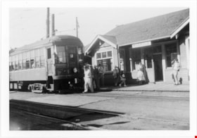
B.C. Electric Railway tram at Marpole Station
https://search.heritageburnaby.ca/link/museumdescription2899
- Repository
- Burnaby Village Museum
- Date
- 28 Sep. 1957
- Collection/Fonds
- Burnaby Village Museum Photograph collection
- Description Level
- Item
- Physical Description
- 1 photograph : b&w ; 9 x 13 cm
- Scope and Content
- Photograph of B.C. Electric Railway tram at Marpole Station on the B.C. Electric Railway Lulu Island branch.
- Repository
- Burnaby Village Museum
- Collection/Fonds
- Burnaby Village Museum Photograph collection
- Description Level
- Item
- Physical Description
- 1 photograph : b&w ; 9 x 13 cm
- Scope and Content
- Photograph of B.C. Electric Railway tram at Marpole Station on the B.C. Electric Railway Lulu Island branch.
- Subjects
- Transportation - Electric Railroads
- Accession Code
- BV012.36.7
- Access Restriction
- No restrictions
- Reproduction Restriction
- No known restrictions
- Date
- 28 Sep. 1957
- Media Type
- Photograph
- Scan Resolution
- 600
- Scan Date
- 2022-07-26
- Notes
- Title based on contents of photograph
- Typewritten text on verso of photograph reads: "A busy scene at the Marpole Station on the / B.C.E.R. Lulu Island branch, as with white / flags up, Special B.C.E.R. #1222, with a gro (sic) / group of rail fans on board, pauses for / orders, before proceeding on. / September 28, 1957"
Images
![B.C. Electric Company, [1958] thumbnail](/media/Hpo/_Data/_Archives_Images/_Unrestricted/001/100-001.jpg?width=280)
B.C. Electric Company
https://search.heritageburnaby.ca/link/archivedescription34691
- Repository
- City of Burnaby Archives
- Date
- [1958]
- Collection/Fonds
- Burnaby Historical Society fonds
- Description Level
- Item
- Physical Description
- 1 photograph : b&w ; 20.2 x 25.6 cm
- Scope and Content
- Photograph of the exterior of the B.C. Electric Co. gas distribution centre building.
- Repository
- City of Burnaby Archives
- Date
- [1958]
- Collection/Fonds
- Burnaby Historical Society fonds
- Subseries
- Photographs subseries
- Physical Description
- 1 photograph : b&w ; 20.2 x 25.6 cm
- Description Level
- Item
- Record No.
- 100-001
- Access Restriction
- No restrictions
- Reproduction Restriction
- Reproduce for fair dealing purposes only
- Accession Number
- BHS2007-04
- Scope and Content
- Photograph of the exterior of the B.C. Electric Co. gas distribution centre building.
- Subjects
- Buildings - Industrial
- Media Type
- Photograph
- Photographer
- Graphic Industries Limited
- Notes
- Title based on contents of photograph
- Printed at bottom right front of photo, "B.C. Electric"
- Stamp on back of photo reads, "Photo by Graphic Industries Ltd. / File No. 4383 / Vancouver, Canada / MUtual 1-4174"
Images
![B.C. Electric Company, [1958] thumbnail](/media/Hpo/_Data/_Archives_Images/_Unrestricted/001/100-001.jpg)

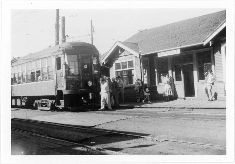
B.C. Electric Railway no. 1232 coming into New Westminster Depot
https://search.heritageburnaby.ca/link/museumdescription2895
- Repository
- Burnaby Village Museum
- Date
- 12 Feb. 1956
- Collection/Fonds
- Burnaby Village Museum Photograph collection
- Description Level
- Item
- Physical Description
- 1 photograph : b&w ; 9 x 9 cm
- Scope and Content
- Photograph of B.C. Electric Railway tram no.1232 coming into New Westminster Depot off the Marpole Line. The Mc & Mc store is visible in the background.
- Repository
- Burnaby Village Museum
- Collection/Fonds
- Burnaby Village Museum Photograph collection
- Description Level
- Item
- Physical Description
- 1 photograph : b&w ; 9 x 9 cm
- Scope and Content
- Photograph of B.C. Electric Railway tram no.1232 coming into New Westminster Depot off the Marpole Line. The Mc & Mc store is visible in the background.
- Subjects
- Transportation - Electric Railroads
- Accession Code
- BV012.36.3
- Access Restriction
- No restrictions
- Reproduction Restriction
- No known restrictions
- Date
- 12 Feb. 1956
- Media Type
- Photograph
- Scan Resolution
- 600
- Scan Date
- 2022-07-26
- Notes
- Title based on contents of photograph
- Typewritten text on verso of photograph reads: "BCER #1232 coming into New Westminster Depot / off the Marpole / Line. / Sunday, Feburary 12, 1956"
Images
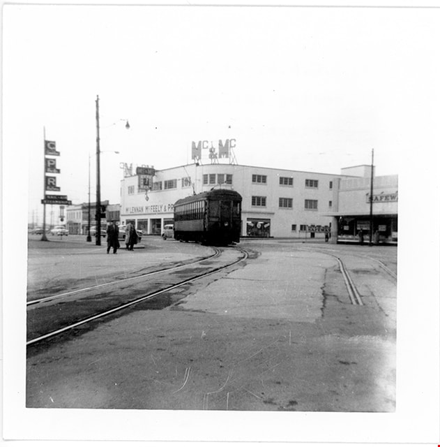
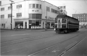
B.C. Electric Railway tram no. 1207 heading west to Marpole
https://search.heritageburnaby.ca/link/museumdescription2901
- Repository
- Burnaby Village Museum
- Date
- 1955
- Collection/Fonds
- Burnaby Village Museum Photograph collection
- Description Level
- Item
- Physical Description
- 1 photograph : b&w ; 9 x 13.5 cm
- Scope and Content
- Photograph of B.C. Electric Railway tram no. 1207 heading west towards Marpole on a Sunday afternoon in 1955. The Mc & Mc (McLennan & McFeeley) store in New Westminster is visible behind.
- Repository
- Burnaby Village Museum
- Collection/Fonds
- Burnaby Village Museum Photograph collection
- Description Level
- Item
- Physical Description
- 1 photograph : b&w ; 9 x 13.5 cm
- Scope and Content
- Photograph of B.C. Electric Railway tram no. 1207 heading west towards Marpole on a Sunday afternoon in 1955. The Mc & Mc (McLennan & McFeeley) store in New Westminster is visible behind.
- Subjects
- Transportation - Electric Railroads
- Accession Code
- BV012.36.9
- Access Restriction
- No restrictions
- Reproduction Restriction
- No known restrictions
- Date
- 1955
- Media Type
- Photograph
- Scan Resolution
- 600
- Scan Date
- 2022-07-26
- Notes
- Title based on contents of photograph
- Typewritten text on verso of photograph reads: "After threading the cross over from the New / Westminster depot, BCER #1207 heads west / to Marpole on a Sunday after noon in 1955. / #1207 has been brought back from the USA and / is now being refurbished in the POCO garage / of B.C. Transit"
Images

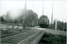
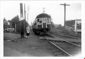
B.C. Electric Railway tram no. 1216 near Byrne Road stop
https://search.heritageburnaby.ca/link/museumdescription2910
- Repository
- Burnaby Village Museum
- Date
- Oct. 1956
- Collection/Fonds
- Burnaby Village Museum Photograph collection
- Description Level
- Item
- Physical Description
- 1 photograph : b&w print ; 9 x 13.5 cm
- Scope and Content
- Photograph of B.C. Electric Railway tram no. 1216 approaching a level crossing and the Byrne Road stop on the New Westminster to Marpole line.
- Repository
- Burnaby Village Museum
- Collection/Fonds
- Burnaby Village Museum Photograph collection
- Description Level
- Item
- Physical Description
- 1 photograph : b&w print ; 9 x 13.5 cm
- Scope and Content
- Photograph of B.C. Electric Railway tram no. 1216 approaching a level crossing and the Byrne Road stop on the New Westminster to Marpole line.
- Accession Code
- BV012.37.8
- Access Restriction
- No restrictions
- Reproduction Restriction
- May be restricted by third party rights
- Date
- Oct. 1956
- Media Type
- Photograph
- Scan Resolution
- 600
- Scan Date
- 2022-07-26
- Notes
- Title based on contents of photograph
- Typewritten text on verso of photograph reads: "On a partly foggy and frosty morning of / October 1956, B.C.E.R. #1216, westbound / to Vancouver on theNew Westminster Div - / ision of the Marpole Line pauses at the / Byrne Road Station."
Images

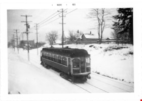
B.C. Electric Railway tram no. 1306 on Central Park Line
https://search.heritageburnaby.ca/link/museumdescription2902
- Repository
- Burnaby Village Museum
- Date
- 1952
- Collection/Fonds
- Burnaby Village Museum Photograph collection
- Description Level
- Item
- Physical Description
- 1 photograph : b&w ; 9 x 13 cm
- Scope and Content
- Phototgraph of B.C. Electric Railway tram no. 1306 running on the tracks between Earles Road and Collingwood west on the Central Park Line. The ground is covered with snow.
- Repository
- Burnaby Village Museum
- Collection/Fonds
- Burnaby Village Museum Photograph collection
- Description Level
- Item
- Physical Description
- 1 photograph : b&w ; 9 x 13 cm
- Scope and Content
- Phototgraph of B.C. Electric Railway tram no. 1306 running on the tracks between Earles Road and Collingwood west on the Central Park Line. The ground is covered with snow.
- Accession Code
- BV012.36.10
- Access Restriction
- No restrictions
- Reproduction Restriction
- No known restrictions
- Date
- 1952
- Media Type
- Photograph
- Scan Resolution
- 600
- Scan Date
- 2022-07-26
- Notes
- Title based on contents of photograph
- "Khulman built BCER #1306 / running between Earles Road and Collingwood / west on Central Park Line 1952 / Earles Road substation in background"
Images

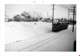
B.C. Electric Railway tram no. 1309 tram on Central Park Line
https://search.heritageburnaby.ca/link/museumdescription2896
- Repository
- Burnaby Village Museum
- Date
- 1953
- Collection/Fonds
- Burnaby Village Museum Photograph collection
- Description Level
- Item
- Physical Description
- 1 photograph : b&w ; 9 x 13 cm
- Scope and Content
- Photograph of B.C. Electric Railway tram no. 1309 travelling along the Central Park Line westbound to Vancouver between Collingwood West and Earls Road after a winter storm. The tracks and hillside are covered with snow.
- Repository
- Burnaby Village Museum
- Collection/Fonds
- Burnaby Village Museum Photograph collection
- Description Level
- Item
- Physical Description
- 1 photograph : b&w ; 9 x 13 cm
- Scope and Content
- Photograph of B.C. Electric Railway tram no. 1309 travelling along the Central Park Line westbound to Vancouver between Collingwood West and Earls Road after a winter storm. The tracks and hillside are covered with snow.
- Accession Code
- BV012.36.4
- Access Restriction
- No restrictions
- Reproduction Restriction
- No known restrictions
- Date
- 1953
- Media Type
- Photograph
- Scan Resolution
- 600
- Scan Date
- 2022-07-26
- Notes
- Title based on contents of photograph
- Typewritten text on verso of photograph reads: "Home built B.C.E.R. #1309 hurries along / Central Park line westbound to Vancovuer / between Collingwood West and Earls Road / after a winter snow storm in 1953"
Images

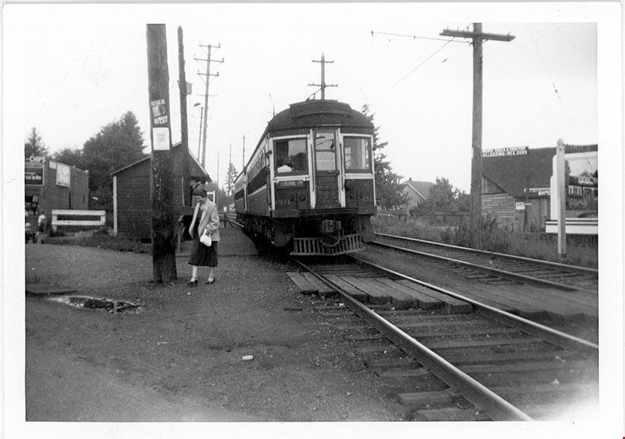
B.C. Electric Railway tram no. 1311 at Jubilee Station
https://search.heritageburnaby.ca/link/museumdescription2900
- Repository
- Burnaby Village Museum
- Date
- 1952
- Collection/Fonds
- Burnaby Village Museum Photograph collection
- Description Level
- Item
- Physical Description
- 1 photograph : b&w ; 9 x 13 cm
- Scope and Content
- Photograph of B.C. Electric Railway tram no. 1311 at Jubilee Station on the Central Park Line westbound towards Vancouver.
- Repository
- Burnaby Village Museum
- Collection/Fonds
- Burnaby Village Museum Photograph collection
- Description Level
- Item
- Physical Description
- 1 photograph : b&w ; 9 x 13 cm
- Scope and Content
- Photograph of B.C. Electric Railway tram no. 1311 at Jubilee Station on the Central Park Line westbound towards Vancouver.
- Subjects
- Transportation - Electric Railroads
- Accession Code
- BV012.36.8
- Access Restriction
- No restrictions
- Reproduction Restriction
- No known restrictions
- Date
- 1952
- Media Type
- Photograph
- Scan Resolution
- 600
- Scan Date
- 2022-07-26
- Notes
- Title based on contents of photograph
- Typewritten text on verso of photograph reads: "B.C.E.R. #1311 and train at Jubilee Station / on Central Park Line westbound to Vancouver / 1952."
Images