Narrow Results By
![Anderson family home, [1930] (date of original), copied 1986 thumbnail](/media/hpo/_Data/_Archives_Images/_Unrestricted/204/204-034.jpg?width=280)
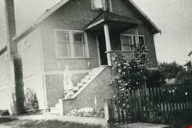
Anderson family home
https://search.heritageburnaby.ca/link/archivedescription35177
- Repository
- City of Burnaby Archives
- Date
- [1930] (date of original), copied 1986
- Collection/Fonds
- Burnaby Historical Society fonds
- Description Level
- Item
- Physical Description
- 1 photograph : b&w ; 12.7 x 17.8 cm print
- Scope and Content
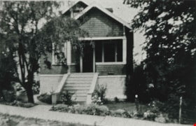
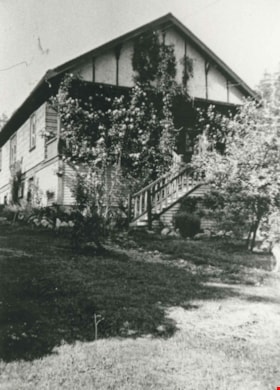
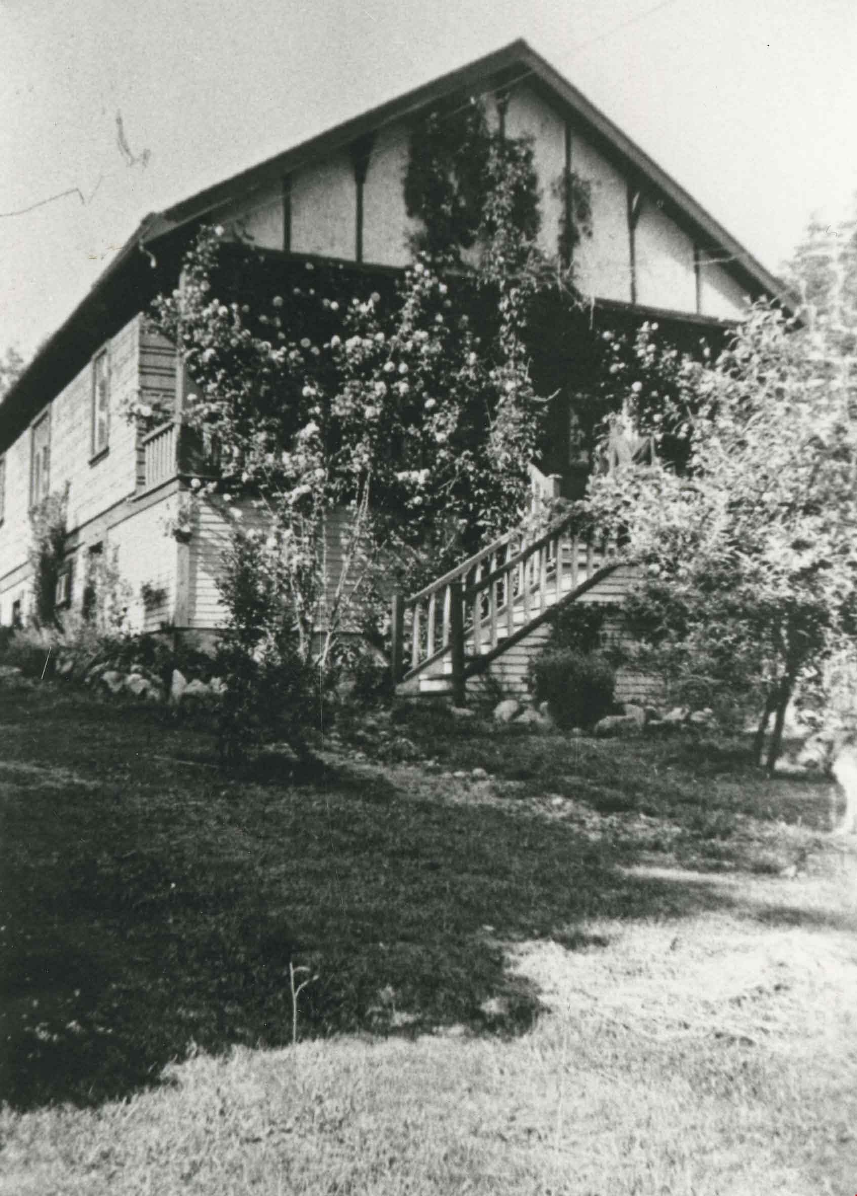
- Photograph of the Anderson family home at 4127 McGill Street in North Burnaby. The house was built ca. 1923.
- Repository
- City of Burnaby Archives
- Date
- [1930] (date of original), copied 1986
- Collection/Fonds
- Burnaby Historical Society fonds
- Subseries
- Pioneer Tales subseries
- Physical Description
- 1 photograph : b&w ; 12.7 x 17.8 cm print
- Description Level
- Item
- Record No.
- 204-034
- Access Restriction
- No restrictions
- Reproduction Restriction
- No known restrictions
- Accession Number
- BHS1988-03
- Scope and Content
- Photograph of the Anderson family home at 4127 McGill Street in North Burnaby. The house was built ca. 1923.
- Subjects
- Buildings - Residential - Houses
- Media Type
- Photograph
- Notes
- Title based on contents of photograph
- Geographic Access
- McGill Street
- Street Address
- 4127 McGill Street
- Historic Neighbourhood
- Vancouver Heights (Historic Neighbourhood)
- Planning Study Area
- Burnaby Heights Area
Images
![Anderson family home, [1930] (date of original), copied 1986 thumbnail](/media/hpo/_Data/_Archives_Images/_Unrestricted/204/204-034.jpg)
![Avalon, [1906] (date of original), copied 1986 thumbnail](/media/hpo/_Data/_Archives_Images/_Unrestricted/204/204-785.jpg?width=280)
Avalon
https://search.heritageburnaby.ca/link/archivedescription35925
- Repository
- City of Burnaby Archives
- Date
- [1906] (date of original), copied 1986
- Collection/Fonds
- Burnaby Historical Society fonds
- Description Level
- Item
- Physical Description
- 1 photograph : b&w ; 12.7 x 17.8 cm print
- Scope and Content
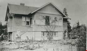
- Photograph of three people and a dog standing in front of the Hart family cottage on Deer Lake.
- Repository
- City of Burnaby Archives
- Date
- [1906] (date of original), copied 1986
- Collection/Fonds
- Burnaby Historical Society fonds
- Subseries
- Pioneer Tales subseries
- Physical Description
- 1 photograph : b&w ; 12.7 x 17.8 cm print
- Description Level
- Item
- Record No.
- 204-785
- Access Restriction
- No restrictions
- Reproduction Restriction
- No known restrictions
- Accession Number
- BHS1988-03
- Scope and Content
- Photograph of three people and a dog standing in front of the Hart family cottage on Deer Lake.
- Media Type
- Photograph
- Notes
- Title based on contents of photograph
- Geographic Access
- Deer Lake
- Deer Lake Avenue
- Street Address
- 6664 Deer Lake Avenue
- Historic Neighbourhood
- Burnaby Lake (Historic Neighbourhood)
- Planning Study Area
- Morley-Buckingham Area
Images
![Avalon, [1906] (date of original), copied 1986 thumbnail](/media/hpo/_Data/_Archives_Images/_Unrestricted/204/204-785.jpg)

Burrard Inlet Squatters
https://search.heritageburnaby.ca/link/archivedescription35583
- Repository
- City of Burnaby Archives
- Date
- 1930 (date of original), copied 1986
- Collection/Fonds
- Burnaby Historical Society fonds
- Description Level
- Item
- Physical Description
- 1 photograph : b&w ; 12.7 x 17.8 cm print
- Scope and Content
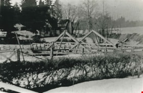
- Photograph of squatters in "Crabtown" along Burrard Inlet. Squatters proliferated during Great Depression, not eliminated until 1950s. Many of shacks were brightly decorated, attractive and clean. This photograph was taken looking West along the southern shoreline (Burnaby side) of Burrard Inlet.
- Repository
- City of Burnaby Archives
- Date
- 1930 (date of original), copied 1986
- Collection/Fonds
- Burnaby Historical Society fonds
- Subseries
- Pioneer Tales subseries
- Physical Description
- 1 photograph : b&w ; 12.7 x 17.8 cm print
- Description Level
- Item
- Record No.
- 204-441
- Access Restriction
- No restrictions
- Reproduction Restriction
- No known restrictions
- Accession Number
- BHS1988-03
- Scope and Content
- Photograph of squatters in "Crabtown" along Burrard Inlet. Squatters proliferated during Great Depression, not eliminated until 1950s. Many of shacks were brightly decorated, attractive and clean. This photograph was taken looking West along the southern shoreline (Burnaby side) of Burrard Inlet.
- Subjects
- Buildings - Residential - Houses
- Geographic Features - Inlets
- Persons - Residents - Squatters
- Media Type
- Photograph
- Notes
- Title based on contents of photograph
Images

Cambell family home
https://search.heritageburnaby.ca/link/archivedescription35786
- Repository
- City of Burnaby Archives
- Date
- 1930 (date of original), copied 1986
- Collection/Fonds
- Burnaby Historical Society fonds
- Description Level
- Item
- Physical Description
- 1 photograph : b&w ; 12.7 x 17.8 cm print
- Scope and Content
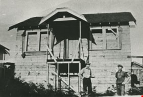
- Photograph of the second Campbell family home at 4120 Eton Street. John Campbell, the family's father, and his friends built this larger house, and then razed the former one on the lot.
- Repository
- City of Burnaby Archives
- Date
- 1930 (date of original), copied 1986
- Collection/Fonds
- Burnaby Historical Society fonds
- Subseries
- Pioneer Tales subseries
- Physical Description
- 1 photograph : b&w ; 12.7 x 17.8 cm print
- Description Level
- Item
- Record No.
- 204-644
- Access Restriction
- No restrictions
- Reproduction Restriction
- No known restrictions
- Accession Number
- BHS1988-03
- Scope and Content
- Photograph of the second Campbell family home at 4120 Eton Street. John Campbell, the family's father, and his friends built this larger house, and then razed the former one on the lot.
- Subjects
- Buildings - Residential - Houses
- Media Type
- Photograph
- Notes
- Title based on contents of photograph
- The former home on this lot is photo 204-643
- Geographic Access
- Eton Street
- Street Address
- 4120 Eton Street
- Historic Neighbourhood
- Vancouver Heights (Historic Neighbourhood)
- Planning Study Area
- Burnaby Heights Area
Images

Campend
https://search.heritageburnaby.ca/link/archivedescription35144
- Repository
- City of Burnaby Archives
- Date
- 1938 (date of original), copied 1986
- Collection/Fonds
- Burnaby Historical Society fonds
- Description Level
- Item
- Physical Description
- 1 photograph : b&w ; 12.7 x 17.8 cm print
- Scope and Content
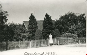
- Photograph of "Campend," the Shankie family home. Janet Shankie is standing in the gateway. The house was formerly numbered 3718 Barker Avenue and later renumbered 5155 Barker Avenue. An annotation at the bottom front of the photograph reads, "Campend 1938."
- Repository
- City of Burnaby Archives
- Date
- 1938 (date of original), copied 1986
- Collection/Fonds
- Burnaby Historical Society fonds
- Subseries
- Pioneer Tales subseries
- Physical Description
- 1 photograph : b&w ; 12.7 x 17.8 cm print
- Description Level
- Item
- Record No.
- 204-001
- Access Restriction
- No restrictions
- Reproduction Restriction
- No known restrictions
- Accession Number
- BHS1988-03
- Scope and Content
- Photograph of "Campend," the Shankie family home. Janet Shankie is standing in the gateway. The house was formerly numbered 3718 Barker Avenue and later renumbered 5155 Barker Avenue. An annotation at the bottom front of the photograph reads, "Campend 1938."
- Subjects
- Buildings - Residential - Houses
- Names
- Bower, Janet Shankie
- Media Type
- Photograph
- Notes
- Title based on caption on photograph
- Geographic Access
- Barker Avenue
- Street Address
- 5155 Barker Avenue
- Historic Neighbourhood
- Central Park (Historic Neighbourhood)
- Planning Study Area
- Garden Village Area
Images

![Claude Hill family home, [1905] (date of original), copied 1986 thumbnail](/media/hpo/_Data/_Archives_Images/_Unrestricted/204/204-770.jpg?width=280)
Claude Hill family home
https://search.heritageburnaby.ca/link/archivedescription35911
- Repository
- City of Burnaby Archives
- Date
- [1905] (date of original), copied 1986
- Collection/Fonds
- Burnaby Historical Society fonds
- Description Level
- Item
- Physical Description
- 1 photograph : b&w ; 12.7 x 17.8 cm print
- Scope and Content
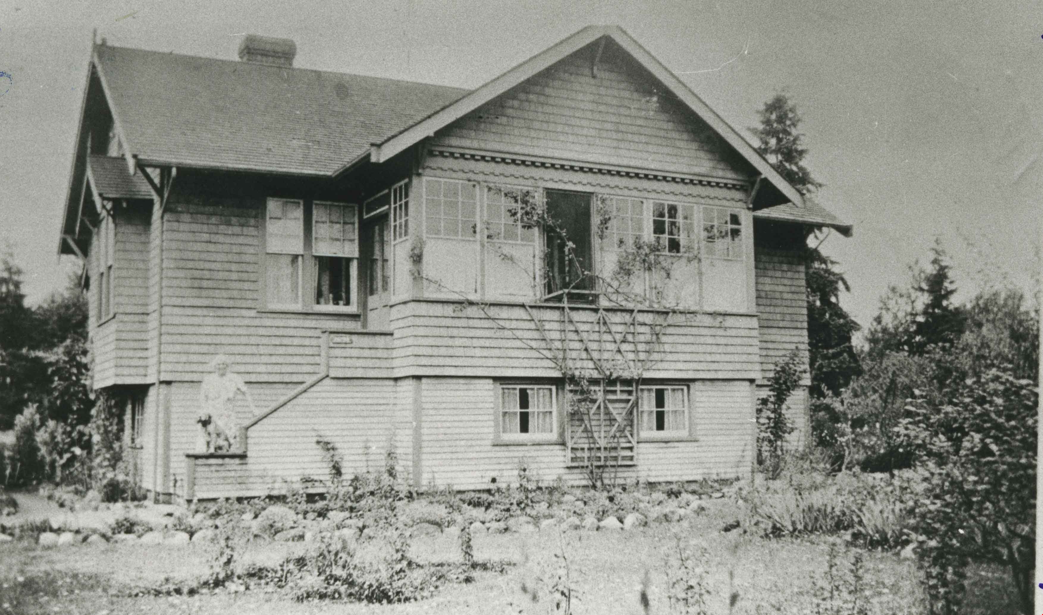
- Photograph of the Claude Hill family home, "Brookfield," built in 1896. He and his family lived there until 1906, when he built a new home on the same property. The property later became the site of the Burnaby Village Museum.
- Repository
- City of Burnaby Archives
- Date
- [1905] (date of original), copied 1986
- Collection/Fonds
- Burnaby Historical Society fonds
- Subseries
- Pioneer Tales subseries
- Physical Description
- 1 photograph : b&w ; 12.7 x 17.8 cm print
- Description Level
- Item
- Record No.
- 204-770
- Access Restriction
- No restrictions
- Reproduction Restriction
- No known restrictions
- Accession Number
- BHS1988-03
- Scope and Content
- Photograph of the Claude Hill family home, "Brookfield," built in 1896. He and his family lived there until 1906, when he built a new home on the same property. The property later became the site of the Burnaby Village Museum.
- Subjects
- Buildings - Residential - Houses
- Media Type
- Photograph
- Notes
- Title based on contents of photograph
- Geographic Access
- Deer Lake Avenue
- Street Address
- 6501 Deer Lake Avenue
- Historic Neighbourhood
- Burnaby Lake (Historic Neighbourhood)
- Planning Study Area
- Morley-Buckingham Area
Images
![Claude Hill family home, [1905] (date of original), copied 1986 thumbnail](/media/hpo/_Data/_Archives_Images/_Unrestricted/204/204-770.jpg)
![Dallamore Family Home, [1900] (date of original), copied 1986 thumbnail](/media/hpo/_Data/_Archives_Images/_Unrestricted/204/204-130.jpg?width=280)
Dallamore Family Home
https://search.heritageburnaby.ca/link/archivedescription35273
- Repository
- City of Burnaby Archives
- Date
- [1900] (date of original), copied 1986
- Collection/Fonds
- Burnaby Historical Society fonds
- Description Level
- Item
- Physical Description
- 1 photograph : b&w ; 12.7 x 17.8 cm print
- Scope and Content
- Photograph of the Dallamore family home on Silver Avenue near the B.C. Electric interurban tracks. Grace Dallamore's grandparents, the Harmers, and her parents, the Dallamores, owned this entire block of land. This house was built ca. 1896 by F.L. Harmer, a carpenter who settled in Burnaby in 189…
- Repository
- City of Burnaby Archives
- Date
- [1900] (date of original), copied 1986
- Collection/Fonds
- Burnaby Historical Society fonds
- Subseries
- Pioneer Tales subseries
- Physical Description
- 1 photograph : b&w ; 12.7 x 17.8 cm print
- Description Level
- Item
- Record No.
- 204-130
- Access Restriction
- No restrictions
- Reproduction Restriction
- No known restrictions
- Accession Number
- BHS1988-03
- Scope and Content
- Photograph of the Dallamore family home on Silver Avenue near the B.C. Electric interurban tracks. Grace Dallamore's grandparents, the Harmers, and her parents, the Dallamores, owned this entire block of land. This house was built ca. 1896 by F.L. Harmer, a carpenter who settled in Burnaby in 1894.
- Media Type
- Photograph
- Notes
- Title based on contents of photograph
- Geographic Access
- Silver Avenue
- Street Address
- 6380 Silver Avenue
- Historic Neighbourhood
- Central Park (Historic Neighbourhood)
- Planning Study Area
- Maywood Area
Images
![Dallamore Family Home, [1900] (date of original), copied 1986 thumbnail](/media/hpo/_Data/_Archives_Images/_Unrestricted/204/204-130.jpg)
![Lewarne family home, [1933] (date of original), copied 1986 thumbnail](/media/hpo/_Data/_Archives_Images/_Unrestricted/204/204-053.jpg?width=280)
Lewarne family home
https://search.heritageburnaby.ca/link/archivedescription35196
- Repository
- City of Burnaby Archives
- Date
- [1933] (date of original), copied 1986
- Collection/Fonds
- Burnaby Historical Society fonds
- Description Level
- Item
- Physical Description
- 1 photograph : b&w ; 12.7 x 20.3 cm print
- Scope and Content
- Photograph of Lewarne family home on Nelson Avenue in Alta Vista.
- Repository
- City of Burnaby Archives
- Date
- [1933] (date of original), copied 1986
- Collection/Fonds
- Burnaby Historical Society fonds
- Subseries
- Pioneer Tales subseries
- Physical Description
- 1 photograph : b&w ; 12.7 x 20.3 cm print
- Description Level
- Item
- Record No.
- 204-053
- Access Restriction
- No restrictions
- Reproduction Restriction
- No known restrictions
- Accession Number
- BHS1988-03
- Scope and Content
- Photograph of Lewarne family home on Nelson Avenue in Alta Vista.
- Subjects
- Buildings - Residential - Houses
- Media Type
- Photograph
- Notes
- Title based on contents of photograph
- Geographic Access
- Nelson Avenue
- Historic Neighbourhood
- Alta-Vista (Historic Neighbourhood)
- Planning Study Area
- Sussex-Nelson Area
Images
![Lewarne family home, [1933] (date of original), copied 1986 thumbnail](/media/hpo/_Data/_Archives_Images/_Unrestricted/204/204-053.jpg)

Lewis family
https://search.heritageburnaby.ca/link/archivedescription35698
- Repository
- City of Burnaby Archives
- Date
- 1903 (date of original), copied 1986
- Collection/Fonds
- Burnaby Historical Society fonds
- Description Level
- Item
- Physical Description
- 1 photograph : b&w ; 12.7 x 17.8 cm print
- Scope and Content
- Photograph of (left to right) Lillie Lewis (sister - later Lillie Porter), William Lewis (father), Evelyn Lewis (sister), and Ernest Lewis (brother) picking strawberries at the side of their house. Note the apple trees all around. The other people in the picture are unidentified hired help.
- Repository
- City of Burnaby Archives
- Date
- 1903 (date of original), copied 1986
- Collection/Fonds
- Burnaby Historical Society fonds
- Subseries
- Pioneer Tales subseries
- Physical Description
- 1 photograph : b&w ; 12.7 x 17.8 cm print
- Description Level
- Item
- Record No.
- 204-556
- Access Restriction
- No restrictions
- Reproduction Restriction
- No known restrictions
- Accession Number
- BHS1988-03
- Scope and Content
- Photograph of (left to right) Lillie Lewis (sister - later Lillie Porter), William Lewis (father), Evelyn Lewis (sister), and Ernest Lewis (brother) picking strawberries at the side of their house. Note the apple trees all around. The other people in the picture are unidentified hired help.
- Subjects
- Occupations - Agricultural Labourers
- Agriculture - Fruit and Berries
- Occupations - Farmers
- Buildings - Residential - Houses
- Media Type
- Photograph
- Photographer
- Cooksley, William Thomas
- Notes
- Title based on contents of photograph
- Geographic Access
- 4th Street
- 18th Avenue
- Historic Neighbourhood
- East Burnaby (Historic Neighbourhood)
- Planning Study Area
- Second Street Area
Images


Lewis family
https://search.heritageburnaby.ca/link/archivedescription35699
- Repository
- City of Burnaby Archives
- Date
- 1904 (date of original), copied 1986
- Collection/Fonds
- Burnaby Historical Society fonds
- Description Level
- Item
- Physical Description
- 1 photograph : b&w ; 12.7 x 17.8 cm print
- Scope and Content
- Photograph of the Lewis family. Left to right: Mrs. Emma Lewis (mother) and children Evelyn, Lizzie, Lillie (later, Lillie Porter), Albert and Ernest in front of their home. Note the cherry trees, mostly Queen Anne reds.
- Repository
- City of Burnaby Archives
- Date
- 1904 (date of original), copied 1986
- Collection/Fonds
- Burnaby Historical Society fonds
- Subseries
- Pioneer Tales subseries
- Physical Description
- 1 photograph : b&w ; 12.7 x 17.8 cm print
- Description Level
- Item
- Record No.
- 204-557
- Access Restriction
- No restrictions
- Reproduction Restriction
- No known restrictions
- Accession Number
- BHS1988-03
- Scope and Content
- Photograph of the Lewis family. Left to right: Mrs. Emma Lewis (mother) and children Evelyn, Lizzie, Lillie (later, Lillie Porter), Albert and Ernest in front of their home. Note the cherry trees, mostly Queen Anne reds.
- Subjects
- Buildings - Residential - Houses
- Media Type
- Photograph
- Notes
- Title based on contents of photograph
- Geographic Access
- 4th Street
- 18th Avenue
- Historic Neighbourhood
- East Burnaby (Historic Neighbourhood)
- Planning Study Area
- Second Street Area
Images

![Love family home, [1908] (date of original), copied 1986 thumbnail](/media/hpo/_Data/_Archives_Images/_Unrestricted/204/204-580.jpg?width=280)
Love family home
https://search.heritageburnaby.ca/link/archivedescription35722
- Repository
- City of Burnaby Archives
- Date
- [1908] (date of original), copied 1986
- Collection/Fonds
- Burnaby Historical Society fonds
- Description Level
- Item
- Physical Description
- 1 photograph : b&w ; 12.7 x 17.8 cm print
- Scope and Content
- Photograph of the Love family home, 1390 Cumberland Road (later renumbered 7651 Cumberland Street), East Burnaby. The house was built by Jesse Love. In 1988, this house was moved to the site of the Burnaby Village Museum at Deer Lake Avenue, where it remains today.
- Repository
- City of Burnaby Archives
- Date
- [1908] (date of original), copied 1986
- Collection/Fonds
- Burnaby Historical Society fonds
- Subseries
- Pioneer Tales subseries
- Physical Description
- 1 photograph : b&w ; 12.7 x 17.8 cm print
- Description Level
- Item
- Record No.
- 204-580
- Access Restriction
- No restrictions
- Reproduction Restriction
- No known restrictions
- Accession Number
- BHS1988-03
- Scope and Content
- Photograph of the Love family home, 1390 Cumberland Road (later renumbered 7651 Cumberland Street), East Burnaby. The house was built by Jesse Love. In 1988, this house was moved to the site of the Burnaby Village Museum at Deer Lake Avenue, where it remains today.
- Media Type
- Photograph
- Notes
- Title based on contents of photograph
- Annotation on bottom of photograph reads, "1390 Cumberland Rd, the old home"
- Geographic Access
- Cumberland Street
- Street Address
- 6501 Deer Lake Avenue
- Historic Neighbourhood
- East Burnaby (Historic Neighbourhood)
- Planning Study Area
- Cariboo-Armstrong Area
Images
![Love family home, [1908] (date of original), copied 1986 thumbnail](/media/hpo/_Data/_Archives_Images/_Unrestricted/204/204-580.jpg)

Marine Drive Game Farm
https://search.heritageburnaby.ca/link/archivedescription35158
- Repository
- City of Burnaby Archives
- Date
- 1930 (date of original), copied 1986
- Collection/Fonds
- Burnaby Historical Society fonds
- Description Level
- Item
- Physical Description
- 1 photograph : b&w ; 12.7 x 17.8 cm print
- Scope and Content
- Photograph of the Marine Drive Game Farm, founded and owned by William "Bill" Greenslade's father, William Greenslade, Sr. It was located at 3295 Marine Drive (later renumbered 5421 Marine Drive).
- Repository
- City of Burnaby Archives
- Date
- 1930 (date of original), copied 1986
- Collection/Fonds
- Burnaby Historical Society fonds
- Subseries
- Pioneer Tales subseries
- Physical Description
- 1 photograph : b&w ; 12.7 x 17.8 cm print
- Description Level
- Item
- Record No.
- 204-015
- Access Restriction
- No restrictions
- Reproduction Restriction
- No known restrictions
- Accession Number
- BHS1988-03
- Scope and Content
- Photograph of the Marine Drive Game Farm, founded and owned by William "Bill" Greenslade's father, William Greenslade, Sr. It was located at 3295 Marine Drive (later renumbered 5421 Marine Drive).
- Names
- Marine Drive Game Farm
- Media Type
- Photograph
- Notes
- Title based on contents of photograph
- Geographic Access
- Marine Drive
- Street Address
- 5421 Marine Drive
- Historic Neighbourhood
- Fraser Arm (Historic Neighbourhood)
- Planning Study Area
- Clinton-Glenwood Area
Images

![Pearson family home, [1930] (date of original), copied 1986 thumbnail](/media/hpo/_Data/_Archives_Images/_Unrestricted/204/204-036.jpg?width=280)
Pearson family home
https://search.heritageburnaby.ca/link/archivedescription35179
- Repository
- City of Burnaby Archives
- Date
- [1930] (date of original), copied 1986
- Collection/Fonds
- Burnaby Historical Society fonds
- Description Level
- Item
- Physical Description
- 1 photograph : b&w ; 12.7 x 17.8 cm print
- Scope and Content
- Photograph of the Pearson family home at 2215 Inverness Street (later renumbered and renamed 6693 Arcola Street) built by George Pearson after arriving from the Prairies.
- Repository
- City of Burnaby Archives
- Date
- [1930] (date of original), copied 1986
- Collection/Fonds
- Burnaby Historical Society fonds
- Subseries
- Pioneer Tales subseries
- Physical Description
- 1 photograph : b&w ; 12.7 x 17.8 cm print
- Description Level
- Item
- Record No.
- 204-036
- Access Restriction
- No restrictions
- Reproduction Restriction
- No known restrictions
- Accession Number
- BHS1988-03
- Scope and Content
- Photograph of the Pearson family home at 2215 Inverness Street (later renumbered and renamed 6693 Arcola Street) built by George Pearson after arriving from the Prairies.
- Subjects
- Buildings - Residential - Houses
- Media Type
- Photograph
- Notes
- Title based on contents of photograph
- Geographic Access
- Arcola Street
- Street Address
- 6693 Arcola Street
- Historic Neighbourhood
- Edmonds (Historic Neighbourhood)
- Planning Study Area
- Kingsway-Beresford Area
Images
![Pearson family home, [1930] (date of original), copied 1986 thumbnail](/media/hpo/_Data/_Archives_Images/_Unrestricted/204/204-036.jpg)
Picken family home
https://search.heritageburnaby.ca/link/archivedescription35468
- Repository
- City of Burnaby Archives
- Date
- 1931 (date of original), copied 1986
- Collection/Fonds
- Burnaby Historical Society fonds
- Description Level
- Item
- Physical Description
- 1 photograph : b&w ; 12.7 x 17.8 cm print
- Scope and Content
- Photograph of the Picken family home, "Aintree" by the Brunette River, with the mailing address of 2600 Cariboo Road, R.R. 2, New Westminster. The number was later changed to 6825 Cariboo Road, and the mail redirected through Burnaby. The Picken family consisted of Stanley B. Picken (dam keeper …
- Repository
- City of Burnaby Archives
- Date
- 1931 (date of original), copied 1986
- Collection/Fonds
- Burnaby Historical Society fonds
- Subseries
- Pioneer Tales subseries
- Physical Description
- 1 photograph : b&w ; 12.7 x 17.8 cm print
- Description Level
- Item
- Record No.
- 204-326
- Access Restriction
- No restrictions
- Reproduction Restriction
- No known restrictions
- Accession Number
- BHS1988-03
- Scope and Content
- Photograph of the Picken family home, "Aintree" by the Brunette River, with the mailing address of 2600 Cariboo Road, R.R. 2, New Westminster. The number was later changed to 6825 Cariboo Road, and the mail redirected through Burnaby. The Picken family consisted of Stanley B. Picken (dam keeper on the Brunette River), his wife Isabel Picken (formerly Isabel Ponton) and their children.
- Media Type
- Photograph
- Notes
- Title based on contents of photograph
- Geographic Access
- Cariboo Road
- Street Address
- 6825 Cariboo Road
- Historic Neighbourhood
- Burquitlam (Historic Neighbourhood)
- Planning Study Area
- Burnaby Lake Area
Images

![Pitman family home, [193-] (date of original), copied 1986 thumbnail](/media/hpo/_Data/_Archives_Images/_Unrestricted/204/204-622.jpg?width=280)
Pitman family home
https://search.heritageburnaby.ca/link/archivedescription35764
- Repository
- City of Burnaby Archives
- Date
- [193-] (date of original), copied 1986
- Collection/Fonds
- Burnaby Historical Society fonds
- Description Level
- Item
- Physical Description
- 1 photograph : b&w ; 12.7 x 17.8 cm print
- Scope and Content
- Photograph of the Pitman family home, 2766 Cassie Avenue (later renumbered 6291 Cassie Avenue), South Burnaby, near the McKay Interurban station.
- Repository
- City of Burnaby Archives
- Date
- [193-] (date of original), copied 1986
- Collection/Fonds
- Burnaby Historical Society fonds
- Subseries
- Pioneer Tales subseries
- Physical Description
- 1 photograph : b&w ; 12.7 x 17.8 cm print
- Description Level
- Item
- Record No.
- 204-622
- Access Restriction
- No restrictions
- Reproduction Restriction
- No known restrictions
- Accession Number
- BHS1988-03
- Scope and Content
- Photograph of the Pitman family home, 2766 Cassie Avenue (later renumbered 6291 Cassie Avenue), South Burnaby, near the McKay Interurban station.
- Subjects
- Buildings - Residential - Houses
- Media Type
- Photograph
- Notes
- Title based on contents of photograph
- Geographic Access
- Cassie Avenue
- Street Address
- 6291 Cassie Avenue
- Historic Neighbourhood
- Central Park (Historic Neighbourhood)
- Planning Study Area
- Maywood Area
Images
![Pitman family home, [193-] (date of original), copied 1986 thumbnail](/media/hpo/_Data/_Archives_Images/_Unrestricted/204/204-622.jpg)
Rigby family home
https://search.heritageburnaby.ca/link/archivedescription35778
- Repository
- City of Burnaby Archives
- Date
- 1930 (date of original), copied 1986
- Collection/Fonds
- Burnaby Historical Society fonds
- Description Level
- Item
- Physical Description
- 1 photograph : b&w ; 12.7 x 17.8 cm print
- Scope and Content
- Photograph of the Rigby family home at 2319 Alder Avenue (later renumbered and renambed 6908 Palm Avenue) in South Burnaby. Identified: (right, wearing cap) Joe Rigby (husband of Edna Armitage). He built this house for his bride after buying a 200 x 50 foot lot for $200, $15 down. The Rigby chil…
- Repository
- City of Burnaby Archives
- Date
- 1930 (date of original), copied 1986
- Collection/Fonds
- Burnaby Historical Society fonds
- Subseries
- Pioneer Tales subseries
- Physical Description
- 1 photograph : b&w ; 12.7 x 17.8 cm print
- Description Level
- Item
- Record No.
- 204-636
- Access Restriction
- No restrictions
- Reproduction Restriction
- No known restrictions
- Accession Number
- BHS1988-03
- Scope and Content
- Photograph of the Rigby family home at 2319 Alder Avenue (later renumbered and renambed 6908 Palm Avenue) in South Burnaby. Identified: (right, wearing cap) Joe Rigby (husband of Edna Armitage). He built this house for his bride after buying a 200 x 50 foot lot for $200, $15 down. The Rigby children, Joe and Doreen, were raised here.
- Subjects
- Buildings - Residential - Houses
- Media Type
- Photograph
- Notes
- Title based on contents of photograph
- Geographic Access
- Palm Avenue
- Street Address
- 6908 Palm Avenue
- Historic Neighbourhood
- Central Park (Historic Neighbourhood)
- Planning Study Area
- Windsor Area
Images

Rorison family home
https://search.heritageburnaby.ca/link/archivedescription35379
- Repository
- City of Burnaby Archives
- Date
- 1930 (date of original), copied 1986
- Collection/Fonds
- Burnaby Historical Society fonds
- Description Level
- Item
- Physical Description
- 1 photograph : b&w ; 12.7 x 17.8 cm print
- Scope and Content
- Photograph of the William Rorison family home at 3907 River Road (later becoming 4593 Marine Drive at Strathern Avenue) in the South Slope area. William Rorison built this house next to another for his mother-in-law. The Rorison family consisted of William Rorison, his wife Alma Rorison (nee Cropl…
- Repository
- City of Burnaby Archives
- Date
- 1930 (date of original), copied 1986
- Collection/Fonds
- Burnaby Historical Society fonds
- Subseries
- Pioneer Tales subseries
- Physical Description
- 1 photograph : b&w ; 12.7 x 17.8 cm print
- Description Level
- Item
- Record No.
- 204-236
- Access Restriction
- No restrictions
- Reproduction Restriction
- No known restrictions
- Accession Number
- BHS1988-03
- Scope and Content
- Photograph of the William Rorison family home at 3907 River Road (later becoming 4593 Marine Drive at Strathern Avenue) in the South Slope area. William Rorison built this house next to another for his mother-in-law. The Rorison family consisted of William Rorison, his wife Alma Rorison (nee Cropley) and their children: Kay (later Kay North), Evelyn, Bill, Hugh, and John.
- Subjects
- Buildings - Residential - Houses
- Media Type
- Photograph
- Notes
- Title based on contents of photograph
- Geographic Access
- Marine Drive
- Street Address
- 4593 Marine Drive
- Historic Neighbourhood
- Fraser Arm (Historic Neighbourhood)
- Planning Study Area
- Sussex-Nelson Area
Images
Rowanlea
https://search.heritageburnaby.ca/link/archivedescription35283
- Repository
- City of Burnaby Archives
- Date
- 1930 (date of original), copied 1986
- Collection/Fonds
- Burnaby Historical Society fonds
- Description Level
- Item
- Physical Description
- 1 photograph: b&w ; 12.7 x 17.8 cm print
- Scope and Content
- Photograph of Urquhart family home after its completion. A woman and her dog are faintly visible standing on the steps. The house was built section by section over several years and called "Rowanlea" because of Rowan trees around property. The home was located at Griffiths Avenue and Burford Street…
- Repository
- City of Burnaby Archives
- Date
- 1930 (date of original), copied 1986
- Collection/Fonds
- Burnaby Historical Society fonds
- Subseries
- Pioneer Tales subseries
- Physical Description
- 1 photograph: b&w ; 12.7 x 17.8 cm print
- Description Level
- Item
- Record No.
- 204-140
- Access Restriction
- No restrictions
- Reproduction Restriction
- No known restrictions
- Accession Number
- BHS1988-03
- Scope and Content
- Photograph of Urquhart family home after its completion. A woman and her dog are faintly visible standing on the steps. The house was built section by section over several years and called "Rowanlea" because of Rowan trees around property. The home was located at Griffiths Avenue and Burford Street. The house was previously numbered 2674, then changed to 6625, and later 6637 Griffiths Avenue.
- Subjects
- Buildings - Residential - Houses
- Media Type
- Photograph
- Notes
- Title based on contents of photograph
- Geographic Access
- Griffiths Avenue
- Street Address
- 6637 Griffiths Avenue
- Historic Neighbourhood
- Edmonds (Historic Neighbourhood)
- Planning Study Area
- Kingsway-Beresford Area
Images
![Setter family home, [1930] (date of original), copied 1986 thumbnail](/media/hpo/_Data/_Archives_Images/_Unrestricted/204/204-009.jpg?width=280)
Setter family home
https://search.heritageburnaby.ca/link/archivedescription35152
- Repository
- City of Burnaby Archives
- Date
- [1930] (date of original), copied 1986
- Collection/Fonds
- Burnaby Historical Society fonds
- Description Level
- Item
- Physical Description
- 1 photograph : b&w ; 12.7 x 17.8 cm print
- Scope and Content
- Photograph of the Setter family's first home near Central Park.
- Repository
- City of Burnaby Archives
- Date
- [1930] (date of original), copied 1986
- Collection/Fonds
- Burnaby Historical Society fonds
- Subseries
- Pioneer Tales subseries
- Physical Description
- 1 photograph : b&w ; 12.7 x 17.8 cm print
- Description Level
- Item
- Record No.
- 204-009
- Access Restriction
- No restrictions
- Reproduction Restriction
- No known restrictions
- Accession Number
- BHS1988-03
- Scope and Content
- Photograph of the Setter family's first home near Central Park.
- Subjects
- Buildings - Residential - Houses
- Media Type
- Photograph
- Notes
- Title based on contents of photograph
- Geographic Access
- Cassie Avenue
- Historic Neighbourhood
- Central Park (Historic Neighbourhood)
- Planning Study Area
- Maywood Area
Images
![Setter family home, [1930] (date of original), copied 1986 thumbnail](/media/hpo/_Data/_Archives_Images/_Unrestricted/204/204-009.jpg)
Speirs family home
https://search.heritageburnaby.ca/link/archivedescription35324
- Repository
- City of Burnaby Archives
- Date
- 1930 (date of original), copied 1986
- Collection/Fonds
- Burnaby Historical Society fonds
- Description Level
- Item
- Physical Description
- 1 photograph : b&w ; 12.7 x 17.8 cm print
- Scope and Content
- Photograph of Dell Speirs in front of the Speirs family home on Watling Street (near Frederick Avenue). Dell was the wife of Bill Speirs.
- Repository
- City of Burnaby Archives
- Date
- 1930 (date of original), copied 1986
- Collection/Fonds
- Burnaby Historical Society fonds
- Subseries
- Pioneer Tales subseries
- Physical Description
- 1 photograph : b&w ; 12.7 x 17.8 cm print
- Description Level
- Item
- Record No.
- 204-181
- Access Restriction
- No restrictions
- Reproduction Restriction
- No known restrictions
- Accession Number
- BHS1988-03
- Scope and Content
- Photograph of Dell Speirs in front of the Speirs family home on Watling Street (near Frederick Avenue). Dell was the wife of Bill Speirs.
- Subjects
- Buildings - Residential - Houses
- Names
- Speirs, Dell
- Media Type
- Photograph
- Notes
- Title based on contents of photograph
- Geographic Access
- Watling Street
- Historic Neighbourhood
- Alta-Vista (Historic Neighbourhood)
- Planning Study Area
- Sussex-Nelson Area
Images
