Narrow Results By
Decade
- 2020s 56
- 2010s 52
- 2000s 24
- 1990s 56
- 1980s 31
- 1970s 53
- 1960s 79
- 1950s 79
- 1940s 59
- 1930s
- 1920s 78
- 1910s 164
- 1900s
- 1890s 25
- 1880s 6
- 1870s 3
- 1860s 3
- 1850s 1
- 1840s 1
- 1830s 1
- 1820s 1
- 1810s 1
- 1800s 1
- 1790s 1
- 1780s 1
- 1770s 1
- 1760s 1
- 1750s 1
- 1740s 1
- 1730s 1
- 1720s 1
- 1710s 1
- 1700s 1
- 1690s 1
- 1680s 1
- 1670s 1
- 1660s 1
- 1650s 1
- 1640s 1
- 1630s 1
- 1620s 1
- 1610s 1
- 1600s 1
Creator
- Bancroft, Rose 1
- Bekins Moving and Storage Company Limited 1
- British Columbia Underwriters' Association 4
- Brown, Donald N. "Don" 1
- Burnaby Village Museum 1
- Burnett, David H. 1
- Burnett, Geoffrey K. 1
- Burnett & McGugan, Engineers and Surveyors 8
- City Map and White Print Co. 1
- City of Burnaby 2
- Coast Map and Blue Print Co. 1
- Digney, Andy 24
![All Saints Church, [ca.1910] thumbnail](/media/hpo/_Data/_BVM_Cartographic_Material/2003/2003_0083_0046_001.jpg?width=280)
All Saints Church
https://search.heritageburnaby.ca/link/museumdescription11924
- Repository
- Burnaby Village Museum
- Date
- [ca.1910]
- Collection/Fonds
- Ronald G. Scobbie collection
- Description Level
- Item
- Physical Description
- 1 plan : black ink and watercol. on paper ; 30.45 x 30.5 cm
- Scope and Content
- Item consists of building insurance plan of "All Saints Church / Lot "A" BK 29 DL 98 GP1 N.W.D.". Watling Street is idenfied to the north of the church building and Royal Oak Avenue to the west.
- Repository
- Burnaby Village Museum
- Collection/Fonds
- Ronald G. Scobbie collection
- Description Level
- Item
- Physical Description
- 1 plan : black ink and watercol. on paper ; 30.45 x 30.5 cm
- Material Details
- Scale 1 inch = 20 feet
- Scope and Content
- Item consists of building insurance plan of "All Saints Church / Lot "A" BK 29 DL 98 GP1 N.W.D.". Watling Street is idenfied to the north of the church building and Royal Oak Avenue to the west.
- Subjects
- Buildings - Religious - Churches
- Accession Code
- BV003.83.46
- Access Restriction
- No restrictions
- Reproduction Restriction
- No known restrictions
- Date
- [ca.1910]
- Media Type
- Cartographic Material
- Scan Resolution
- 600
- Scan Date
- 15-Jan-2021
- Scale
- 100
- Notes
- Transcribed title
- Note in pencil on verso reads: ""All Saints Church / Lot "A" BK 29 DL 98 / Scale 1 inch = 20 feet"
- Note in balck in on verso reads: "3704"
Images
![All Saints Church, [ca.1910] thumbnail](/media/hpo/_Data/_BVM_Cartographic_Material/2003/2003_0083_0046_001.jpg)
Andy Digney Film
https://search.heritageburnaby.ca/link/archivedescription85335
- Repository
- City of Burnaby Archives
- Date
- [between 1934 and 1961]
- Collection/Fonds
- Digney Family fonds
- Description Level
- Item
- Physical Description
- 2 optical discs (approx. 2 hrs, 40 min) : digital, b&w, col., si.
- Scope and Content
- Item is a collection of 18 short films on DVD. These films were created by Andy Digney using his 8 mm camera and provide views of the Digney family gatherings, trips, vacations at home and abroad. They also provide glimpses of Burnaby parades, celebrations and the Digney Speedway. The 18 segments h…
- Repository
- City of Burnaby Archives
- Date
- [between 1934 and 1961]
- Collection/Fonds
- Digney Family fonds
- Physical Description
- 2 optical discs (approx. 2 hrs, 40 min) : digital, b&w, col., si.
- Description Level
- Item
- Record No.
- 562-003
- Access Restriction
- No restrictions
- Reproduction Restriction
- May be restricted by third party rights
- Accession Number
- 2014-04
- Scope and Content
- Item is a collection of 18 short films on DVD. These films were created by Andy Digney using his 8 mm camera and provide views of the Digney family gatherings, trips, vacations at home and abroad. They also provide glimpses of Burnaby parades, celebrations and the Digney Speedway. The 18 segments have all been described at item level.
- Subjects
- Animals - Dogs
- Recreational Activities - Fishing
- Recreational Activities - Camping
- Recreational Activities - Picnics
- Geographic Features - Rivers
- Events - Parades
- Media Type
- Moving Images
- Photographer
- Digney, Andy
- Creator
- Digney, Andy
- Notes
- Title based on contents of film
- The original 8mm film footage was digitized and broken down into 18 segments, reflecting the original order. Items are described as 562-003-1 : 562-003-18

Andy's first film
https://search.heritageburnaby.ca/link/archivedescription85207
- Repository
- City of Burnaby Archives
- Date
- 1934
- Collection/Fonds
- Digney Family fonds
- Description Level
- Item
- Physical Description
- 1 film clip (10 min., 3 sec.) : digital, b&w, col., si.
- Scope and Content
- Item is a silent digitized (DVD) film segment with footage identified as 'Reel 1' . Film footage flucuates between black and white and colour providing a look into activities of Andy Digney and his family while they resided in Brandon, Manitoba. Footage documents outdoor activities such as camping…
- Repository
- City of Burnaby Archives
- Date
- 1934
- Collection/Fonds
- Digney Family fonds
- Physical Description
- 1 film clip (10 min., 3 sec.) : digital, b&w, col., si.
- Description Level
- Item
- Record No.
- 562-003-1
- Access Restriction
- No restrictions
- Reproduction Restriction
- May be restricted by third party rights
- Accession Number
- 2014-04
- Scope and Content
- Item is a silent digitized (DVD) film segment with footage identified as 'Reel 1' . Film footage flucuates between black and white and colour providing a look into activities of Andy Digney and his family while they resided in Brandon, Manitoba. Footage documents outdoor activities such as camping,fishing, boating, golfing, swimming, picnicing and a parade in Banff, Alberta.
- Subjects
- Animals - Dogs
- Recreational Activities - Fishing
- Recreational Activities - Camping
- Recreational Activities - Picnics
- Recreational Activities - Golf
- Geographic Features - Rivers
- Events - Parades
- Media Type
- Moving Images
- Photographer
- Digney, Andy
- Creator
- Digney, Andy
- Notes
- Title based on contents of film
Images
Video
Andy's first film, 1934
![Anglican Church, [ca.1910] thumbnail](/media/hpo/_Data/_BVM_Cartographic_Material/2003/2003_0083_0043_001.jpg?width=280)
Anglican Church
https://search.heritageburnaby.ca/link/museumdescription11921
- Repository
- Burnaby Village Museum
- Date
- [ca.1910]
- Collection/Fonds
- Ronald G. Scobbie collection
- Description Level
- Item
- Physical Description
- 1 plan : black ink and watercol. on paper ; 30.45 x 30.5 cm
- Scope and Content
- Item consists of building insurance plan of "Anglican Church / Lot 2 BK 37 DL69, GP.1, N.W.D. (15th Ave. (Dominion) is identified to the north of Lots 1, 2 and 3).
- Repository
- Burnaby Village Museum
- Collection/Fonds
- Ronald G. Scobbie collection
- Description Level
- Item
- Physical Description
- 1 plan : black ink and watercol. on paper ; 30.45 x 30.5 cm
- Material Details
- Scale 1 inch = 20 feet
- Scope and Content
- Item consists of building insurance plan of "Anglican Church / Lot 2 BK 37 DL69, GP.1, N.W.D. (15th Ave. (Dominion) is identified to the north of Lots 1, 2 and 3).
- Subjects
- Buildings - Religious - Churches
- Accession Code
- BV003.83.43
- Access Restriction
- No restrictions
- Reproduction Restriction
- No known restrictions
- Date
- [ca.1910]
- Media Type
- Cartographic Material
- Scan Resolution
- 600
- Scan Date
- 15-Jan-2021
- Scale
- 100
- Notes
- Transcribed title
- Note in pencil on verso reads: "Anglican Church / Lot 2 Bk 37 DL69 / 1"=20' "
- Note in balck in on verso reads: "3704"
Images
![Anglican Church, [ca.1910] thumbnail](/media/hpo/_Data/_BVM_Cartographic_Material/2003/2003_0083_0043_001.jpg)
Bancroft family subseries
https://search.heritageburnaby.ca/link/archivedescription63795
- Repository
- City of Burnaby Archives
- Date
- [1900]-1979
- Collection/Fonds
- Burnaby Historical Society fonds
- Description Level
- Subseries
- Physical Description
- Textual records and other materials
- Scope and Content
- Subseries consists of publications, correspondence and other miscellaneous papers relating to the Bancroft family's interests and work history. Topics include gardening, raising poultry, the Liberal government and the Royal Canadian Air Force. Also included in the subseries are photographs of the…
- Repository
- City of Burnaby Archives
- Date
- [1900]-1979
- Collection/Fonds
- Burnaby Historical Society fonds
- Subseries
- Bancroft family subseries
- Physical Description
- Textual records and other materials
- Description Level
- Subseries
- Accession Number
- BHS1986-44
- BHS2004-06
- Scope and Content
- Subseries consists of publications, correspondence and other miscellaneous papers relating to the Bancroft family's interests and work history. Topics include gardening, raising poultry, the Liberal government and the Royal Canadian Air Force. Also included in the subseries are photographs of the Bancroft family and friends and ephemera pertaining to agricultural farming and the air force.
- History
- Rose Croucher was born to Ann Eliza "Annie" (b. August 1861, d. 1962) and R. Coucher in January 1895. In 1907, the Croucher family moved to British Columbia. As a student, Rose studied geometrical drawing using Blair’s Canadian Drawing Series workbooks. On on February 21, 1914, Rose married James Oakes Bancroft in Vancouver, BC. Together they had three children: James A. (b. 1916 or 1917), Rosie (date unknown), and George E. (b. August 1927). The Bancroft family were poultry farmers throughout the early 1900s, transporting their farmed eggs from Burnaby to the Hudson’s Bay Company Vancouver using the British Columbia Electric Railway system. Rose Bancroft also served as Secretary-Treasurer of the Central Park Poultry Co-op Association in the 1920s until her husband's death in 1930 at the age of 42. In the late thirties and early forties, while James A. Bancroft was stationed in Calgary with the Royal Canadian Air Force, his younger siblings lived together with their mother and grandmother at 1963 21st Avenue in Burnaby. Rosie Bancroft studied French and English history in Social Studies in 1937; her brother George studied the seasons in General Science II in 1942. Rose died in 1965 at the age of 76.
- Media Type
- Textual Record
- Photograph
- Cartographic Material
- Creator
- Bancroft, Rose
- Notes
- MSS030, PC490, PC507, and MSS110
- Title based on creator and contents of subseries
B.C. Electric Railway cutoff - Highland Park
https://search.heritageburnaby.ca/link/archivedescription751
- Repository
- City of Burnaby Archives
- Date
- 1912-1951
- Collection/Fonds
- City Council and Office of the City Clerk fonds
- Description Level
- File
- Physical Description
- 3 folders textual records and cartographic material
- Scope and Content
- File contains correspondence, reports, Council minutes, and agreements between the Corporation of the District of Burnaby and the B.C. Electric Co. regarding the construction of the Highland Park Cut-off. File also includes 1912 blueprint "Plan of Portion of 20th Street in DL171 and 53, Gp. 1, NWD…
- Repository
- City of Burnaby Archives
- Date
- 1912-1951
- Collection/Fonds
- City Council and Office of the City Clerk fonds
- Physical Description
- 3 folders textual records and cartographic material
- Description Level
- File
- Record No.
- 2489
- Accession Number
- 2001-02
- Scope and Content
- File contains correspondence, reports, Council minutes, and agreements between the Corporation of the District of Burnaby and the B.C. Electric Co. regarding the construction of the Highland Park Cut-off. File also includes 1912 blueprint "Plan of Portion of 20th Street in DL171 and 53, Gp. 1, NWD, Bby."
- Media Type
- Textual Record
- Cartographic Material
- Notes
- Plans/maps are located in file and have not been moved to map case.
Board of Railway Commissioners
https://search.heritageburnaby.ca/link/archivedescription396
- Repository
- City of Burnaby Archives
- Date
- 1909-1912
- Collection/Fonds
- City Council and Office of the City Clerk fonds
- Description Level
- File
- Physical Description
- Textual record, cartographic material, and architectural drawings
- Scope and Content
- File contains correspondence and reports related to the activities of the Board of Railway Commissioners such as the movement of stations, culvert work, and the maintenance of crossings. File also includes white linen plan and blueprint plans (4) of culverts at Cariboo Road and V.W. and Y.Rlwy Jun…
- Repository
- City of Burnaby Archives
- Date
- 1909-1912
- Collection/Fonds
- City Council and Office of the City Clerk fonds
- Physical Description
- Textual record, cartographic material, and architectural drawings
- Description Level
- File
- Record No.
- 2096
- Accession Number
- 2001-02
- Scope and Content
- File contains correspondence and reports related to the activities of the Board of Railway Commissioners such as the movement of stations, culvert work, and the maintenance of crossings. File also includes white linen plan and blueprint plans (4) of culverts at Cariboo Road and V.W. and Y.Rlwy Junction, 1911.
- Notes
- Plans/maps are located in file and have not been moved to map case.
Boundary Plan - Location for Burnaby Council of the West Boundary of Lots 161 and 175 Group One
https://search.heritageburnaby.ca/link/archivedescription8042
- Repository
- City of Burnaby Archives
- Date
- [1909]
- Collection/Fonds
- City Council and Office of the City Clerk fonds
- Description Level
- Item
- Physical Description
- Cartographic material
- Scope and Content
- Item consists of one plan on waxed linen with colour ink noting the western boundary of District Lots 161 and 175.
- Repository
- City of Burnaby Archives
- Date
- [1909]
- Collection/Fonds
- City Council and Office of the City Clerk fonds
- Physical Description
- Cartographic material
- Description Level
- Item
- Record No.
- 10997
- Accession Number
- 2001-02
- Scope and Content
- Item consists of one plan on waxed linen with colour ink noting the western boundary of District Lots 161 and 175.
- Media Type
- Cartographic Material
- Notes
- Located in map case.
Brandon, Manitoba
https://search.heritageburnaby.ca/link/archivedescription85231
- Repository
- City of Burnaby Archives
- Date
- 1934
- Collection/Fonds
- Digney Family fonds
- Description Level
- Item
- Physical Description
- 1 film clip (14 min., 12 sec.) : digital, b&w, col., si.
- Scope and Content
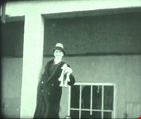
- Item is a silent digitized (DVD) film segment with footage identified as 'Reel 2' . Film footage flucuates between black and white and colour opening with a glimpse of a dog show in the winter outside the Oak Theatre in Brandon, Manitoba. Andy Digney appears in a hat in front of a poster. He sol…
- Repository
- City of Burnaby Archives
- Date
- 1934
- Collection/Fonds
- Digney Family fonds
- Physical Description
- 1 film clip (14 min., 12 sec.) : digital, b&w, col., si.
- Description Level
- Item
- Record No.
- 562-003-2
- Access Restriction
- No restrictions
- Reproduction Restriction
- May be restricted by third party rights
- Accession Number
- 2014-04
- Scope and Content
- Item is a silent digitized (DVD) film segment with footage identified as 'Reel 2' . Film footage flucuates between black and white and colour opening with a glimpse of a dog show in the winter outside the Oak Theatre in Brandon, Manitoba. Andy Digney appears in a hat in front of a poster. He sold the Oak Theatre in 1935 when the family moved to British Columbia. Other glimpses provide a view of an ice jam on the Assinboine River,Brandon floods, the Sandhills animal farm, the North Hill Motorcycle hill climb and an RCMP show in Regina.
- Media Type
- Moving Images
- Photographer
- Digney, Andy
- Creator
- Digney, Andy
- Notes
- Title based on contents of film
Images

Video
Brandon, Manitoba, 1934
![Broadview Presbyterian Church, [ca.1910] thumbnail](/media/hpo/_Data/_BVM_Cartographic_Material/2003/2003_0083_0049_001.jpg?width=280)
Broadview Presbyterian Church
https://search.heritageburnaby.ca/link/museumdescription11927
- Repository
- Burnaby Village Museum
- Date
- [ca.1910]
- Collection/Fonds
- Ronald G. Scobbie collection
- Description Level
- Item
- Physical Description
- 1 plan : black ink and watercol. on paper ; 30.45 x 30.5 cm
- Scope and Content
- Item consists of building insurance plan of "Broadview Presbyterian Church / Lot 6, BK 31, DL 69 / GP1 N.W.D." . Fourteenth Avenue (Manor) is identified to the north and Douglas Ave. to the east.
- Repository
- Burnaby Village Museum
- Collection/Fonds
- Ronald G. Scobbie collection
- Description Level
- Item
- Physical Description
- 1 plan : black ink and watercol. on paper ; 30.45 x 30.5 cm
- Material Details
- Scale 1 inch = 20 feet
- Scope and Content
- Item consists of building insurance plan of "Broadview Presbyterian Church / Lot 6, BK 31, DL 69 / GP1 N.W.D." . Fourteenth Avenue (Manor) is identified to the north and Douglas Ave. to the east.
- Subjects
- Buildings - Religious - Churches
- Accession Code
- BV003.83.49
- Access Restriction
- No restrictions
- Reproduction Restriction
- No known restrictions
- Date
- [ca.1910]
- Media Type
- Cartographic Material
- Scan Resolution
- 600
- Scan Date
- 15-Jan-2021
- Scale
- 100
- Notes
- Transcribed title
- Note in pencil on verso reads: "Broadview Presbyterian Church / Lot 6, BK 31, DL 69 / 1" = 20' "
- Note in balck in on verso reads: "3704"
Images
![Broadview Presbyterian Church, [ca.1910] thumbnail](/media/hpo/_Data/_BVM_Cartographic_Material/2003/2003_0083_0049_001.jpg)
![Burnaby, [between 1937 and 1938] thumbnail](/media/Hpo/_Data/_Archives_Moving_Images/_Unrestricted/562-002-5.jpg?width=280)
Burnaby
https://search.heritageburnaby.ca/link/archivedescription85235
- Repository
- City of Burnaby Archives
- Date
- [between 1937 and 1938]
- Collection/Fonds
- Digney Family fonds
- Description Level
- Item
- Physical Description
- 1 film clip (9 min., 26 sec.) : digital, b&w, col., si.
- Scope and Content
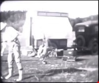
- Item is a silent digitized film segment identified as Reel 5. The film segment opens with black and white footage of a Burnaby May Day Parade. Children are seen in costumes pushing carriages and bicycles along with pets as they come to gather at Central Park for judging. This event is followed with…
- Repository
- City of Burnaby Archives
- Date
- [between 1937 and 1938]
- Collection/Fonds
- Digney Family fonds
- Physical Description
- 1 film clip (9 min., 26 sec.) : digital, b&w, col., si.
- Description Level
- Item
- Record No.
- 562-003-5
- Access Restriction
- No restrictions
- Reproduction Restriction
- May be restricted by third party rights
- Accession Number
- 2014-04
- Scope and Content
- Item is a silent digitized film segment identified as Reel 5. The film segment opens with black and white footage of a Burnaby May Day Parade. Children are seen in costumes pushing carriages and bicycles along with pets as they come to gather at Central Park for judging. This event is followed with colour footage of a gymkhana event with people riding horses at the Lubbock farm in Burnaby and closes with Victory Bond fundraising outside the Oak Theatre, a parade on Kingsway and contrails from an airplane. Many of the men can be seen marching in the parade with their A.R.P. (Air Raid Precautions) uniforms and arm bands.
- Media Type
- Moving Images
- Photographer
- Digney, Andy
- Creator
- Digney, Andy
- Notes
- Title based on contents of film
- Geographic Access
- Kingsway
- Historic Neighbourhood
- Central Park (Historic Neighbourhood)
- Planning Study Area
- Sussex-Nelson Area
Images
![Burnaby, [between 1937 and 1938] thumbnail](/media/Hpo/_Data/_Archives_Moving_Images/_Unrestricted/562-002-5.jpg)
Video
Burnaby, [between 1937 and 1938]
Burnaby, [between 1937 and 1938]
https://search.heritageburnaby.ca/media/hpo/_Data/_Archives_Moving_Images/_Unrestricted/562-003-5.m4v![Burnaby and Digney recreational events, [between 1934 and 1938] thumbnail](/media/Hpo/_Data/_Archives_Moving_Images/_Unrestricted/562-003-3.jpg?width=280)
Burnaby and Digney recreational events
https://search.heritageburnaby.ca/link/archivedescription85208
- Repository
- City of Burnaby Archives
- Date
- [between 1934 and 1938]
- Collection/Fonds
- Digney Family fonds
- Description Level
- Item
- Physical Description
- 1 film clip (10 min., 30 sec.) : digital, b&w, col., si.
- Scope and Content
- Item is a silent digitized colour and black and white film segment identified as Reel 3. The film segment opens with footage of Digney family automobile travels and of Pelican Lake, Alberta where the family spent their summer, the footage switches to footage of a parade somewhere in the Rockies (B…
- Repository
- City of Burnaby Archives
- Date
- [between 1934 and 1938]
- Collection/Fonds
- Digney Family fonds
- Physical Description
- 1 film clip (10 min., 30 sec.) : digital, b&w, col., si.
- Description Level
- Item
- Record No.
- 562-003-3
- Access Restriction
- No restrictions
- Reproduction Restriction
- May be restricted by third party rights
- Accession Number
- 2014-04
- Scope and Content
- Item is a silent digitized colour and black and white film segment identified as Reel 3. The film segment opens with footage of Digney family automobile travels and of Pelican Lake, Alberta where the family spent their summer, the footage switches to footage of a parade somewhere in the Rockies (Banff) which begins in black and white and changes to colour format. This is followed by colour footage of car racing at the Digney Speedway located on 10 acres of property on MacPherson Ave. Jelopy stock car racing is seen taking place with crowds of people looking on.
- Subjects
- Sports - Swimming
- Events - Parades
- Persons - Children
- Persons - Crowds
- Sports - Automobile Racing
- Media Type
- Moving Images
- Photographer
- Digney, Andy
- Creator
- Digney, Andy
- Notes
- Title based on contents of film
- Geographic Access
- MacPherson Avenue
- Historic Neighbourhood
- Alta-Vista (Historic Neighbourhood)
- Planning Study Area
- Clinton-Glenwood Area
Images
![Burnaby and Digney recreational events, [between 1934 and 1938] thumbnail](/media/Hpo/_Data/_Archives_Moving_Images/_Unrestricted/562-003-3.jpg)
Video
Burnaby and Digney recreational events, [between 1934 and 1938]
Burnaby and Digney recreational events, [between 1934 and 1938]
https://search.heritageburnaby.ca/media/hpo/_Data/_Archives_Moving_Images/_Unrestricted/562-003-3.m4vBurnaby Image Bank subseries
https://search.heritageburnaby.ca/link/archivedescription64462
- Repository
- City of Burnaby Archives
- Date
- [1910] (date of original) -1993
- Collection/Fonds
- Burnaby Historical Society fonds
- Description Level
- Subseries
- Physical Description
- Photographs and other material
- Scope and Content
- Subseries consists of the SFU/Burnaby Centennial Committee's Image Bank project records. Records include: Image Bank database and backups in a variety of formats; 813 photographs collected by Simon Fraser University Archives staff; eleven screened negatives from the Burnaby Image Bank that were us…
- Repository
- City of Burnaby Archives
- Date
- [1910] (date of original) -1993
- Collection/Fonds
- Burnaby Historical Society fonds
- Subseries
- Burnaby Image Bank subseries
- Physical Description
- Photographs and other material
- Description Level
- Subseries
- Access Restriction
- Open Access
- Accession Number
- BHS1999-03
- BHS2004-13
- BHS2001-15
- Scope and Content
- Subseries consists of the SFU/Burnaby Centennial Committee's Image Bank project records. Records include: Image Bank database and backups in a variety of formats; 813 photographs collected by Simon Fraser University Archives staff; eleven screened negatives from the Burnaby Image Bank that were used for the publication "Burnaby: A Cultural Inventory and Resource Guide"; and one VHS tape and DVD access copy of "Burnaby's Photographic Family Album / Burnaby Image Bank Collection / Volume 1 / 1992" which was created by the Committee for public viewing and purchase. The collection of photographs for the Image Bank project were gathered from various donors to commemorate the Centennial of the City of Burnaby. All photographs were collected from Burnaby families' personal albums by Simon Fraser University Archives staff during 1991 with a focus on the history of the people and the landscape of Burnaby. Photographs were collected from every decade for every neighbourhood in effort to describe the City's evolving ethnic, cultural and physical landscape. In March 1992, 20 of these images were selected by a jury for their aesthetic quality and displayed at the Bennett Library Gallery at Simon Fraser University for the "Images of Burnaby" exhibition. This exhibit travelled to various locations between 1992-1993 within Burnaby and Douglas College in New Westminster. The entire 800+ collection was made available for public purchase and viewing on video cassette. As well, each Burnaby school and each branch of the Burnaby Public Library received their own VHS copy for information and research purposes. The "Image Bank" video collection was buried alongside the video "Images and Voices of Burnaby" in the City of Burnaby's time capsule, mounted at City Hall in 1992.
- Media Type
- Photograph
- Textual Record
- Moving Images
- Creator
- SFU/Burnaby Centennial Committee
- Notes
- Title based on contents of subseries
- PC 370, MSS131, MSS088, MI577

Burnaby Park track
https://search.heritageburnaby.ca/link/museumdescription11918
- Repository
- Burnaby Village Museum
- Date
- June 30, 1932
- Collection/Fonds
- Ronald G. Scobbie collection
- Description Level
- Item
- Physical Description
- 1 survey plan : ink on waxed linen sheet ; 27 x 39 cm
- Scope and Content
- Item consists of a survey plan titled “Burnaby Park Track”.
- Repository
- Burnaby Village Museum
- Collection/Fonds
- Ronald G. Scobbie collection
- Description Level
- Item
- Physical Description
- 1 survey plan : ink on waxed linen sheet ; 27 x 39 cm
- Scope and Content
- Item consists of a survey plan titled “Burnaby Park Track”.
- Accession Code
- BV003.83.41
- Access Restriction
- No restrictions
- Reproduction Restriction
- No known restrictions
- Date
- June 30, 1932
- Media Type
- Cartographic Material
- Notes
- Transcribed title
- Note in pencil reads: ‘4222”
Images

![Burnaby Sports Day, [between 1936 and 1939] thumbnail](/media/Hpo/_Data/_Archives_Moving_Images/_Unrestricted/562-002-3.jpg?width=280)
Burnaby Sports Day
https://search.heritageburnaby.ca/link/archivedescription85204
- Repository
- City of Burnaby Archives
- Date
- [between 1936 and 1939]
- Collection/Fonds
- Digney Family fonds
- Description Level
- Item
- Physical Description
- 1 film clip (8 min., 37 sec.) : digital, col., si.
- Scope and Content
- Item is a digitized copy of a silent colour film segment with footage of the annual Sports Day events held at Burnaby Central Park. The film opens with an unidentified dedication ceremony and tree planting in an unknown location and switches to students marching into Central Park. Hundreds of child…
- Repository
- City of Burnaby Archives
- Date
- [between 1936 and 1939]
- Collection/Fonds
- Digney Family fonds
- Physical Description
- 1 film clip (8 min., 37 sec.) : digital, col., si.
- Description Level
- Item
- Record No.
- 562-002-3
- Access Restriction
- No restrictions
- Reproduction Restriction
- May be restricted by third party rights
- Accession Number
- 2012-15
- Scope and Content
- Item is a digitized copy of a silent colour film segment with footage of the annual Sports Day events held at Burnaby Central Park. The film opens with an unidentified dedication ceremony and tree planting in an unknown location and switches to students marching into Central Park. Hundreds of children and Youth are showcased in sporting field events and competitions such as track and field sports, acrobatics, gymnastics, dancing, leap frog, skipping, rugby.
- Subjects
- Events - Parades
- Occupations
- Occupations - Labourers
- Organizations - Mens' Societies and Clubs
- Organizations - Womens' Societies and Clubs
- Media Type
- Moving Images
- Photographer
- Digney, Andy
- Creator
- Digney, Andy
- Notes
- Title based on contents of film
- Film clip originates from digitized version of original 16 mm film footage (item 562-002). This segment was part of digitized portion titled 'May Day Events'
- Geographic Access
- Kingsway
- Central Park
- Street Address
- 3883 Imperial Street
- Historic Neighbourhood
- Central Park (Historic Neighbourhood)
- Planning Study Area
- Sussex-Nelson Area
Images
![Burnaby Sports Day, [between 1936 and 1939] thumbnail](/media/Hpo/_Data/_Archives_Moving_Images/_Unrestricted/562-002-3.jpg)
Video
Burnaby Sports Day, [between 1936 and 1939]
Burnaby Sports Day, [between 1936 and 1939]
https://search.heritageburnaby.ca/media/hpo/_Data/_Archives_Moving_Images/_Unrestricted/562-002-3.m4v![Burnaby, Vancouver and the north shore, [between 1937 and 1938] thumbnail](/media/Hpo/_Data/_Archives_Moving_Images/_Unrestricted/562-003-6.jpg?width=280)
Burnaby, Vancouver and the north shore
https://search.heritageburnaby.ca/link/archivedescription85238
- Repository
- City of Burnaby Archives
- Date
- [between 1937 and 1938]
- Collection/Fonds
- Digney Family fonds
- Description Level
- Item
- Physical Description
- 1 film clip (5 min., 21 sec.) : digital, b&w, col., si.
- Scope and Content
- Item is a silent digitized film segment identified as Reel 6. The film segment opens with colour footage of people lawn bowling at Burnaby's Central Park. Dot Digney, Sid and Connie Swan can be seen bowling. This footage is followed with Andy Digney and Charles E. Jones at the Bird's of Paradise b…
- Repository
- City of Burnaby Archives
- Date
- [between 1937 and 1938]
- Collection/Fonds
- Digney Family fonds
- Physical Description
- 1 film clip (5 min., 21 sec.) : digital, b&w, col., si.
- Description Level
- Item
- Record No.
- 562-003-6
- Access Restriction
- No restrictions
- Reproduction Restriction
- May be restricted by third party rights
- Accession Number
- 2014-04
- Scope and Content
- Item is a silent digitized film segment identified as Reel 6. The film segment opens with colour footage of people lawn bowling at Burnaby's Central Park. Dot Digney, Sid and Connie Swan can be seen bowling. This footage is followed with Andy Digney and Charles E. Jones at the Bird's of Paradise bird sanctuary followed by footage of Stanley Park. The footage continues and interchanges between black and white and colour as the Digney's take a ferry ride to North Vancouver where they visit the Capilano Suspension Bridge and Fishermen's Cove. The reel closes with footage of skiers on Grouse Mountain and a fire at Pier D in 1938.
- Media Type
- Moving Images
- Photographer
- Digney, Andy
- Creator
- Digney, Andy
- Notes
- Title based on contents of film
- Geographic Access
- Kingsway
- Historic Neighbourhood
- Central Park (Historic Neighbourhood)
- Planning Study Area
- Kingsway-Beresford Area
Images
![Burnaby, Vancouver and the north shore, [between 1937 and 1938] thumbnail](/media/Hpo/_Data/_Archives_Moving_Images/_Unrestricted/562-003-6.jpg)
Video
Burnaby, Vancouver and the north shore, [between 1937 and 1938]
Burnaby, Vancouver and the north shore, [between 1937 and 1938]
https://search.heritageburnaby.ca/media/hpo/_Data/_Archives_Moving_Images/_Unrestricted/562-003-6.m4vCameron Road
https://search.heritageburnaby.ca/link/archivedescription324
- Repository
- City of Burnaby Archives
- Date
- [1904]
- Collection/Fonds
- City Council and Office of the City Clerk fonds
- Description Level
- File
- Physical Description
- Textual record and cartographic material
- Scope and Content
- File contains Cameron Road Plan.
- Repository
- City of Burnaby Archives
- Date
- [1904]
- Collection/Fonds
- City Council and Office of the City Clerk fonds
- Physical Description
- Textual record and cartographic material
- Description Level
- File
- Record No.
- 2017
- Accession Number
- 2001-02
- Scope and Content
- File contains Cameron Road Plan.
- Media Type
- Textual Record
- Cartographic Material
- Notes
- Plans/maps are located in file and have not been moved to map case.
Cancellation of plan - Block 2, DL 77
https://search.heritageburnaby.ca/link/archivedescription1142
- Repository
- City of Burnaby Archives
- Date
- [Between 1890 - 1918]
- Collection/Fonds
- City Council and Office of the City Clerk fonds
- Description Level
- File
- Physical Description
- Textual record and cartographic material
- Scope and Content
- Files consists of cancellation of plan Block 2, DL 77 and two accompanied blueprints 434 (April 8, 1890) and 238 (December 30, 1887)
- Repository
- City of Burnaby Archives
- Date
- [Between 1890 - 1918]
- Collection/Fonds
- City Council and Office of the City Clerk fonds
- Physical Description
- Textual record and cartographic material
- Description Level
- File
- Record No.
- 2933
- Accession Number
- 2001-02
- Scope and Content
- Files consists of cancellation of plan Block 2, DL 77 and two accompanied blueprints 434 (April 8, 1890) and 238 (December 30, 1887)
- Media Type
- Textual Record
- Cartographic Material
- Notes
- Plan of Lot 77, group 1 NWD : M9-B-1-4. Plan of subdivision of blocks 2-6, lot 77, group 1 NWD : M9-B-1-5
Capitol Hill replotting - Sundry
https://search.heritageburnaby.ca/link/archivedescription1607
- Repository
- City of Burnaby Archives
- Date
- 1931-1933
- Collection/Fonds
- City Council and Office of the City Clerk fonds
- Description Level
- File
- Physical Description
- 2 folders textual records and cartographic material
- Scope and Content
- File contains records pertaining to the replotting of Capitol Hill, including a blueprint of sidewalk over tracks at Ardley, B.C. Also includes a draft of bylaw # 1452.
- Repository
- City of Burnaby Archives
- Date
- 1931-1933
- Collection/Fonds
- City Council and Office of the City Clerk fonds
- Physical Description
- 2 folders textual records and cartographic material
- Description Level
- File
- Record No.
- 3420
- Accession Number
- 2001-02
- Scope and Content
- File contains records pertaining to the replotting of Capitol Hill, including a blueprint of sidewalk over tracks at Ardley, B.C. Also includes a draft of bylaw # 1452.
- Media Type
- Textual Record
- Cartographic Material
- Notes
- Plans/maps are located in file and have not been moved to map case.
Children's theatrical performance at the Oak Theatre
https://search.heritageburnaby.ca/link/archivedescription85469
- Repository
- City of Burnaby Archives
- Date
- 1939
- Collection/Fonds
- Digney Family fonds
- Description Level
- Item
- Physical Description
- 1 film clip (1 min., 36 sec.) : digital, b&w ; si.
- Scope and Content
- Item is a digitized copy of a black and white film segment of an unidentified theatrical production at the Oak Theatre with children as the performers. Children appear in costume with some dressed as mice or rats and cats dancing and performing on the stage while others are dressed as townsfolk. Th…
- Repository
- City of Burnaby Archives
- Date
- 1939
- Collection/Fonds
- Digney Family fonds
- Physical Description
- 1 film clip (1 min., 36 sec.) : digital, b&w ; si.
- Description Level
- Item
- Record No.
- 562-002-5
- Access Restriction
- No restrictions
- Reproduction Restriction
- May be restricted by third party rights
- Accession Number
- 2012-15
- Scope and Content
- Item is a digitized copy of a black and white film segment of an unidentified theatrical production at the Oak Theatre with children as the performers. Children appear in costume with some dressed as mice or rats and cats dancing and performing on the stage while others are dressed as townsfolk. The play closely resembles the folk tale 'The Pied Piper of Hamelin' (also known as The Pan Piper, the Rat Catcher of Hamelin).
- Names
- Oak Theatre
- Media Type
- Moving Images
- Photographer
- Digney, Andy
- Creator
- Digney, Andy
- Notes
- Title based on contents of film
- Film clip originates from digitized version of original 16 mm film footage (item 562-002). This segment was part of digitized portion titled 'Royal Visit'
- Storage location refers to location of DVD containing this clip. See 562-002 notes for more information. Additional copies of video file stored in Permanent drive accession folder.
- Geographic Access
- Kingsway
- Central Park
- Historic Neighbourhood
- Central Park (Historic Neighbourhood)
- Planning Study Area
- Sussex-Nelson Area
Images
Video
Children's theatrical performance at the Oak Theatre, 1939
Children's theatrical performance at the Oak Theatre, 1939
https://search.heritageburnaby.ca/media/hpo/_Data/_Archives_Moving_Images/_Unrestricted/562-002-5.m4v![Copy of Official British Columbia Road Maps, [193-] thumbnail](/media/hpo/_Data/_BVM_Cartographic_Material/1972/1972_0179_0001_001.jpg?width=280)
Copy of Official British Columbia Road Maps
https://search.heritageburnaby.ca/link/museumdescription18945
- Repository
- Burnaby Village Museum
- Date
- [193-]
- Collection/Fonds
- Burnaby Village Museum Map collection
- Physical Description
- 1 map : lithographic print on sheet ; 43 x 56 cm folded to 22 x 11 cm
- Scope and Content
- Item consists of Road maps of British Columbia presented by Union Oil Company of Canada Limited. Includes seventeen maps printed on both sides of sheet. One side of sheet includes ten separate road maps titled "Cariboo"; "Chilcotin Plateau"; "150 Mile House to Prince George"; "Prince George - Burns…
- Repository
- Burnaby Village Museum
- Collection/Fonds
- Burnaby Village Museum Map collection
- Physical Description
- 1 map : lithographic print on sheet ; 43 x 56 cm folded to 22 x 11 cm
- Material Details
- Scale not defined
- Scope and Content
- Item consists of Road maps of British Columbia presented by Union Oil Company of Canada Limited. Includes seventeen maps printed on both sides of sheet. One side of sheet includes ten separate road maps titled "Cariboo"; "Chilcotin Plateau"; "150 Mile House to Prince George"; "Prince George - Burns Lake"; "Burns Lake - Hazelton"; "Similkameen - Nicola"; "Salmon Arm to Revelstoke"; "Ashcroft to Salmon Arm / Kamloops to Vernon"; "Okanagan Valley"; "Boundary District". Other side of sheet includes seven road maps titled "Vancouver Island"; "Vancouver to Yale"' "Fraser Canyon Section Cariboo Road"; "Lytton to 150 Mile House"; "Arrow and Kootenay Lakes"; "The Kootenays"; "Columbia Valley". When folded, cover of maps reads "COPY OF / OFFICIAL / BRITISH COLUMBIA / ROAD-MAPS" / Presented by / UNION OIL / COMPANY / of Canada Ltd."; verso of cover includes advertisement for Union Motor oil "MOTORITE"; inside cover includes advertisement for Union Gasoline with title reading "See Canada's Evergreen Playground".
- Responsibility
- Union Oil Company of Canada Limited
- Accession Code
- HV972.179.1
- Access Restriction
- No restrictions
- Reproduction Restriction
- No known restrictions
- Date
- [193-]
- Media Type
- Cartographic Material
- Scan Resolution
- 600
- Scan Date
- 2023-08-17
- Notes
- Title based on contents of map
Images
![Copy of Official British Columbia Road Maps, [193-] thumbnail](/media/hpo/_Data/_BVM_Cartographic_Material/1972/1972_0179_0001_001.jpg)

Crossing - B.C. Electric Railway Co.
https://search.heritageburnaby.ca/link/archivedescription657
- Repository
- City of Burnaby Archives
- Date
- 1909-1913
- Collection/Fonds
- City Council and Office of the City Clerk fonds
- Description Level
- File
- Physical Description
- Textual record and cartographic material
- Scope and Content
- File contains correspondence and reports pertaining to crossings on B.C. Electric Railway lines at Cariboo, Hastings, Boundary, Gilley, Jubilee, McKay, and Patterson.
- Repository
- City of Burnaby Archives
- Date
- 1909-1913
- Collection/Fonds
- City Council and Office of the City Clerk fonds
- Physical Description
- Textual record and cartographic material
- Description Level
- File
- Record No.
- 2382
- Accession Number
- 2001-02
- Scope and Content
- File contains correspondence and reports pertaining to crossings on B.C. Electric Railway lines at Cariboo, Hastings, Boundary, Gilley, Jubilee, McKay, and Patterson.
- Media Type
- Textual Record
- Cartographic Material
- Notes
- Vancouver and Lulu Island Railway Westminster and Eburne Byrne Road Crossing at Station 355 : M9-A-6-5; Trapp Road Crossing at Station 425 : M9-A-6-6
Crossings - Great Northern Railway
https://search.heritageburnaby.ca/link/archivedescription807
- Repository
- City of Burnaby Archives
- Date
- 1913-1951
- Collection/Fonds
- City Council and Office of the City Clerk fonds
- Description Level
- File
- Physical Description
- Textual record and cartographic material
- Scope and Content
- File contains agreement for the construction of a sidewalk by the Railway Company, and correspondence related to these transactions. File also includes blueprint plan of sidewalk over [GNR] tracks and right of way for the Corporation of the District of Burnaby, 1931; blueprint "Sketch Showing Sigh…
- Repository
- City of Burnaby Archives
- Date
- 1913-1951
- Collection/Fonds
- City Council and Office of the City Clerk fonds
- Physical Description
- Textual record and cartographic material
- Description Level
- File
- Record No.
- 2558
- Accession Number
- 2001-02
- Scope and Content
- File contains agreement for the construction of a sidewalk by the Railway Company, and correspondence related to these transactions. File also includes blueprint plan of sidewalk over [GNR] tracks and right of way for the Corporation of the District of Burnaby, 1931; blueprint "Sketch Showing Sight Clearance and Distances and Sperling Avenue Grade Crossing" [c1945]; and blueprint "Plan of Proposed Road Crossing of Phillips Avenue."
- Media Type
- Textual Record
- Cartographic Material
- Notes
- Plans/maps are located in file and have not been moved to map case.
C.W. Parker no. 119 carousel series
https://search.heritageburnaby.ca/link/museumdescription17810
- Repository
- Burnaby Village Museum
- Date
- [190-] (date of originals) - 2012
- Collection/Fonds
- Burnaby Village Museum fonds
- Description Level
- Series
- Physical Description
- 238 photographs + 3 audio cassettes + 2 sound recordings (mp3) + 6 videocassettes + 8 video recordings (mp4)
- Scope and Content
- Series consists of records created and adminstered by the Burnaby Village Museum pertaining to the history, acquistion, restoration, preservation and documentation of the C.W. Parker no. 119 carousel. Series have been arranged into the following subseries: 1) Carousel photographs subseries 2) Caro…
- Repository
- Burnaby Village Museum
- Collection/Fonds
- Burnaby Village Museum fonds
- Description Level
- Series
- Physical Description
- 238 photographs + 3 audio cassettes + 2 sound recordings (mp3) + 6 videocassettes + 8 video recordings (mp4)
- Scope and Content
- Series consists of records created and adminstered by the Burnaby Village Museum pertaining to the history, acquistion, restoration, preservation and documentation of the C.W. Parker no. 119 carousel. Series have been arranged into the following subseries: 1) Carousel photographs subseries 2) Carousel sound recordings and films subseries
- History
- "The C.W. Parker no. 119 carousel was built in 1912 in Leavenworth Kansas by the Charles Wallace Parker Company. It was the one hundred and nineteenth carousel made by the company and was so named the C.W. Parker no. 119 carousel. In 1913 the carousel was sold to Mr. F.K. Leggett of Houston Texas for $5,886.00 and was originally equipped with a steam engine and ""wishbones/grass-hopper/jumping horse"" mechanisms. It toured Texas for two years with the Lone Star Circus until 1915 when the machine was shipped back to the factory. It is believed that the machine was rebuilt by the factory with fancier horses and heavier rounding boards referred to as the “Superior” style. Some of the horses were built around 1917 and some between 1920 and 1922. The factory records consulted do not tell for certain where the machine went between 1915 and 1936, possibly to San Jose, California from 1918 until 1922 and then to San Francisco California, or Tacoma, Washington. Accounts from the family of James W. "Jimmy" Robertson, supervisor of rides for Happyland, tell of him travelling with his wife Dora Robertson to Washington, Oregon and California in the fall of 1935 or early 1936 to pick up a new carousel for Happyland. By May 1936, the C.W. Parker no. 119 carousel was in operation in Happlyland inside Hastings Park. The Parker #119 carousel was installed in a pavilion in Happyland which had been built in 1928 by a rival company (Philadelphia Toboggan Company - P.T.C.) and was located next to the "Shoot the Chutes" ride in Hastings Park. Here it remained until Happyland was demolished in 1957. The C.W. Parker no. 119 carousel was then moved to a new small pavilion in Playland until that too was demolished in 1972. From 1972 to 1990, the C.W. Parker no. 119 carousel was operated outdoors inside Playland, and was put away each winter. In 1989 it was announced that the carousel would be sold off horse by horse at an auction in New York. Venus Solano and Doug McCallum and other local people came together to save the carousel and formed The Lower Mainland Association of Friends of the Vancouver Carousel (also known as "Friends of the Carousel"). The first directors of the society consisted of, President and Chairman, Venus Solano; Secretary, Doug McCallum; Director, Keith Jamieson and Director, Nina Freid Rhodes. In May 1989, the Friends of the Carousel approached the Burnaby Village Museum Association who agreed to provide a home for the carousel, pending the approval of Burnaby Municipal Council. Don Wrigley who was president of the Burnaby Village Museum Association joined the board of The Friends of the Carousel as a liaison. The Friends of the Carousel first acquired two horses from the carousel, who were named Julius and Belle. These two carousel horses were used in fundraising over the summer of 1990, at which time the carousel was operating again for a short time inside Playland. The carousel horse named Julius was restored by William Dentzel III (a descendant of one of North America’s original carousel manufacturers) and the carousel horse named Belle was partially stripped and repaired. These carousel horses served as before and after examples of restoration. In June 1990 Don Wrigley was elected as president of The Friends of the Carousel and they set about raising the $350,000 to purchase the carousel and begin restoration work. With a lot of hard work, the help of the Government of British Columbia and the support of the Municipality of Burnaby, the carousel was purchased. Funds were also raised by The Friends of the Carousel to pay for the restoration, and Burnaby agreed to build a new pavilion for it as a Centennial project. Keith Jamieson, a carousel expert, was brought in to coordinate the rebuilding project and restoration work. The Centennial Parker Carousel (C.W. Parker no. 119 carousel) and the Don Wrigley Pavilion where the carousel is housed, opened at Burnaby Village Museum on March 25, 1993.
- Accession Code
- BV013.19
- BV019.21
- BV019.39
- BV020.5
- BV020.12
- BV022.2
- X5124
- X5125
- Date
- [190-] (date of originals) - 2012
- Media Type
- Photograph
- Moving Images
- Sound Recording
- Related Material
- Lower Mainland Association of the Friends of the Vancouver Carousel fonds
- Keith Jamieson fonds
- Faye Diamond fonds
- See also: Burnaby Village Museum artifacts for the C.W. Parker no. 119 carousel as well as souvenir memorabilia from Lower Mainland Association of Friends of the Vancouver Carousel
- Arrangement
- Records have been created by various staff members of Burnaby Village Museum during the acquistion and research of the carousel. Some records were compiled together into a collection by subject and arranged according to their general material designations within the Burnaby Village Museum archival collection.
- Notes
- Title based on contents of series
- Further accruals are expected
- Contact Burnaby Village Museum to access sound recordings and moving images
Daily Telegraph War Map of Germany with bombing sites
https://search.heritageburnaby.ca/link/museumdescription20312
- Repository
- Burnaby Village Museum
- Date
- [before 1938] (date of creation of map), annotations added [between 1943 and 1945]
- Collection/Fonds
- Joseph H.C. Corsbie fonds
- Description Level
- Item
- Physical Description
- 1 map : col. lithographic print ; 51 x 77 cm
- Scope and Content
- Item consists of a map entitled "Daily Telegraph War Map of Germany" with secondary title "Daily Telegraph WAR MAP No. 10 Revised Edition". Map was produced prior to the Second World War [pre-Munich International Boundary lines]. Map depicts approximately 47 N to 55 N and from 3E to 22E. The countr…
- Repository
- Burnaby Village Museum
- Collection/Fonds
- Joseph H.C. Corsbie fonds
- Description Level
- Item
- Physical Description
- 1 map : col. lithographic print ; 51 x 77 cm
- Scope and Content
- Item consists of a map entitled "Daily Telegraph War Map of Germany" with secondary title "Daily Telegraph WAR MAP No. 10 Revised Edition". Map was produced prior to the Second World War [pre-Munich International Boundary lines]. Map depicts approximately 47 N to 55 N and from 3E to 22E. The country of Germany sits at the centre of the map bordered by Holland, Belgium and France to the west; Switzerland, Austria and Hungary to the south; Lithuania, Poland, Czechoslavakia, Hungary and Romania to the east and Denmark and the Baltic Sea to the north. Annotations in green ink on the map mark areas of Germany that were bombed during World War Two and were added by Royal Canadian Air Force First Officer Joseph (Joe) H. Corsbie during his service.
- Creator
- Geographia Limited
- Publisher
- Hutchinsons & Co. (Publishers Ltd.) LONDON & MELBORNE"
- Parallel Title
- WAR MAP No. 10 Revised Edition
- Subjects
- Wars - World War, 1939-1945
- Accession Code
- BV020.31.35
- Access Restriction
- No restrictions
- Reproduction Restriction
- No known restrictions
- Date
- [before 1938] (date of creation of map), annotations added [between 1943 and 1945]
- Media Type
- Cartographic Material
- Notes
- Title based on contents of map
- Label printed on verso of map reads: "Daily Telegraph / War Map No. 10 / GERMANY / (REVISED EDITION) / PRICE 1/-NET"
- Copyright. "GEOGRAPHIA" LTD. 167 FLEET STREET, LONDON, E.C.4
- Specially drawn for the Daily Telegraph by "Geographia" Ltd."
- Scale: "Heights in English Feet / Scale of English Miles / Kilometres"
Digney Family fonds
https://search.heritageburnaby.ca/link/archivedescription85415
- Repository
- City of Burnaby Archives
- Date
- 1936-19[61]
- Collection/Fonds
- Digney Family fonds
- Description Level
- Fonds
- Physical Description
- 1 photograph : b&w + 1 film reel : col. ; 16mm + 7 optical discs (DVDs) + 1 portable drive
- Scope and Content
- Fonds consists of a reel of film (digitized into four segments) created by Andy Digney; a panorama photograph of the Digney Pee-Wee Bowling League from 1958 or 1959; and 18 film segments on DVD that were originally created by Andy Digney between 1934 and 1961 and digitized by his grandson Paul Dign…
- Repository
- City of Burnaby Archives
- Date
- 1936-19[61]
- Collection/Fonds
- Digney Family fonds
- Physical Description
- 1 photograph : b&w + 1 film reel : col. ; 16mm + 7 optical discs (DVDs) + 1 portable drive
- Description Level
- Fonds
- Access Restriction
- No restrictions
- Reproduction Restriction
- May be restricted by third party rights
- Scope and Content
- Fonds consists of a reel of film (digitized into four segments) created by Andy Digney; a panorama photograph of the Digney Pee-Wee Bowling League from 1958 or 1959; and 18 film segments on DVD that were originally created by Andy Digney between 1934 and 1961 and digitized by his grandson Paul Digney in 2012. The 16mm film is divided into the following segments: the Oak Theatre in 1936 (construction and opening); the Royal Visit (from the King and Queen) in 1939; Burnaby Sports and May Day events (ca. 1937); and the Labour parade (ca. 1935). The 18 film segments contain footage of the Digney family at their home in Brandon, Manitoba, and Burnaby; views of the Oak Theatre and Digney Speedway in operation; and their travels throughout British Columbia and abroad. The 18 film segments are described at the item level and titled: Andy's first film; Brandon, Manitoba; Burnaby and Digney recreational events; Trip to Kamloops; Burnaby; Burnaby, Vancouver and the north shore; Galiano Island, Oak Theatre and Calgary; Travels to Ontario, Quebec and England; Travels to England #2; Travels to England #3; Parades; Digney family in Burnaby; Paul Digney and family; Digney family and the Oak Theatre gardens; Digney family at Bonsor Avenue and family outings; Building and opening the Digney Speedway; Digney family travel the praries; and San Francisco Trip.
- History
- Andy Digney was born in London, England, on July 27, 1886. His given names were Andrew Charles. In 1905, he immigrated with his elder brother to Raymore, Saskatchewan, and worked on a farm. In 1914, he met and married Alice Swan and in 1920 they had their one and only child, Ernest ('Dig'). The young family lived in Beatty, Saskatchewan, where they ran a small general store with a pool hall over the top. Andy sold the store and they moved to Carberry, Manitoba, where Andy worked selling lightning rods and hanging wallpaper. At this time, he met and formed a partnership with someone who owned a hand cranked move projector and in the evenings, he and his wife traveled to church halls in neighbouring towns, showing movies. Eventually, Digney purchased his own movie projector and opened a small theatre in Carberry. He worked odd jobs during the daytime and projected movies in his small theatre at night. Eventually he made enough money to move to Brandon, Manitoba, where he purchased a restaurant, which he turned into a theatre with living quarters above. Andy called the theatre 'The Oak' since the mighty oak was strong and stood forever. After starting the first Oak Theatre in Brandon, Manitoba, when talking pictures came along, Andy Digney, his wife Alice and son Ernest ('Dig') moved to Burnaby in 1935 and chose the site of their new theatre and home at the corner of Kingsway and Marlborough. The Oak Theatre - which opened on August 4, 1937 - was hailed as an artistic masterpiece for its ultra modern white stucco exterior, floodlights and pink-and-green neon marquee. The interior featured a mirrored ceiling, fireplace, and aquarium and had a colour scheme of orchid, royal blue, silver and black. Andy was a very involved member of the Burnaby community, becoming the founding president of the Lion's club and the chairman of the committee raising money for war bonds during World War II. In 1944, Andy suffered a severe heart attack, forcing him to retire, so in 1945, he sold the theatre to Odeon Theatres of Canada who continued to operate at this location until 1968 when competition forced its closure and demolition. Andy and his family relocated to a home on Bonsor Avenue on 3/4 acres where he spent much of his time cultivating a lovely garden. In about 1946, Andy was approached by the B.C. Midget Auto Racing Association [original name retained for historical accuracy], who were looking for a good location to race the smaller racing cars popular at the time. Andy was interested and purchased 10 acres of property located near the corner of Irmin Street and MacPherson Avenue and built a race track. The Digney Speedway opened on July 8, 1948, with stands that had capacity of holding 4500 people. In 1949, when the popularity of this kind of racing declined, Digney started racing roadsters. However, he struggled to find local drivers, and it was expensive to bring in drivers from elsewhere. In 1951, Digney found a winner: jalopy racing. Local men would buy 1930s cars and strip them down, remove the glass, and weld the doors shut. By early 1952 over 40 cars were showing up for jalopy races. By the early 1950s, the Speedway was well established, with coverage in the sports pages and on radio. Andy's son Dig worked at the race track but moved away with his wife in 1951 to work in Seattle. Dig and his wife Joyce, along with their two young sons, Paul and Bruce, returned to Burnaby in 1953, moving into a 550-square-foot apartment located above the Digney Speedway restrooms. In 1954, Simpson Sears built a large store on Kingsway and their parking lot came up to the back garden of the family home on Bonsor Avenue. Andy thought of building small stores on his property but in the end decided to build a bowling alley, clearing out his beautiful garden. The Digney Bowl opened on August 19, 1955, and Andy, Alice, Dig, and Joyce all worked at both the Speedway and the bowling alley. In 1956, Andy decided to finally retire and sold the bowling alley and home to his son Dig, which he paid for over time. Dig and his family moved into the house on Bonsor Avenue and ran the bowling alley until their son Bruce took over in 1980. Andy Digney died in 1964 while travelling with his wife in England. Alice died on June 3, 1982, and Dig died on November 27, 2009.
- Media Type
- Moving Images
- Photographer
- Digney, Andy
- Creator
- Digney family
- Notes
- Title based on contents of fonds
- Photo/MI catalogue 562
Digney family home at Christmas
https://search.heritageburnaby.ca/link/archivedescription85470
- Repository
- City of Burnaby Archives
- Date
- 1939
- Collection/Fonds
- Digney Family fonds
- Description Level
- Item
- Physical Description
- 1 film clip (1min., 18 sec.) : digital, col. ; si.
- Scope and Content
- Item is a digitized copy of a silent colour film segment of the Digney family at Christmas. Film opens with views of a rhododendrun bush and moves into footage showing the outside and inside their home at Christmas time.
- Repository
- City of Burnaby Archives
- Date
- 1939
- Collection/Fonds
- Digney Family fonds
- Physical Description
- 1 film clip (1min., 18 sec.) : digital, col. ; si.
- Description Level
- Item
- Record No.
- 562-002-6
- Access Restriction
- No restrictions
- Reproduction Restriction
- May be restricted by third party rights
- Accession Number
- 2012-15
- Scope and Content
- Item is a digitized copy of a silent colour film segment of the Digney family at Christmas. Film opens with views of a rhododendrun bush and moves into footage showing the outside and inside their home at Christmas time.
- Subjects
- Holidays - Christmas
- Names
- Digney, Andy
- Media Type
- Moving Images
- Photographer
- Digney, Andy
- Creator
- Digney, Andy
- Notes
- Title based on contents of film
- Film clip originates from digitized version of original 16 mm film footage (item 562-002). This segment was part of digitized portion titled 'Royal Visit'
- Geographic Access
- Central Park
- Kingsway
- Historic Neighbourhood
- Central Park (Historic Neighbourhood)
- Planning Study Area
- Sussex-Nelson Area
Images

Video
Digney family home at Christmas, 1939
Digney family home at Christmas, 1939
https://search.heritageburnaby.ca/media/hpo/_Data/_Archives_Moving_Images/_Unrestricted/562-002-6.m4v![Digney family in Burnaby, [between 1939 and 1959] thumbnail](/media/Hpo/_Data/_Archives_Moving_Images/_Unrestricted/562-003-12.jpg?width=280)
Digney family in Burnaby
https://search.heritageburnaby.ca/link/archivedescription85249
- Repository
- City of Burnaby Archives
- Date
- [between 1939 and 1959]
- Collection/Fonds
- Digney Family fonds
- Description Level
- Item
- Physical Description
- 1 film clip (5 min., 17sec.) : digital, col., si.
- Scope and Content
- Item is a digitized film colour segment identified as Reel 12. The film is a compilation of Digney family events. The film opens with children Paul and Bruce Digney running around the Digney family yard at their home on Bonsor Avenue with Andy and Ernest (Dig) Digney looking on. This is followed by…
- Repository
- City of Burnaby Archives
- Date
- [between 1939 and 1959]
- Collection/Fonds
- Digney Family fonds
- Physical Description
- 1 film clip (5 min., 17sec.) : digital, col., si.
- Description Level
- Item
- Record No.
- 562-003-12
- Access Restriction
- No restrictions
- Reproduction Restriction
- May be restricted by third party rights
- Accession Number
- 2014-04
- Scope and Content
- Item is a digitized film colour segment identified as Reel 12. The film is a compilation of Digney family events. The film opens with children Paul and Bruce Digney running around the Digney family yard at their home on Bonsor Avenue with Andy and Ernest (Dig) Digney looking on. This is followed by interspersed footage of the family's pet dog Nero and puppies along with some brief glimpses of the Royal visit (King George VI and Queen Elizabeth) and cavilicade in 1939 along Kingsway. The film then switches to footage of Digney family Christmas festivities, a cat playing with a fish in a bowl and summer time at Pelican Lake in the 1940s and ends with a dog playing with a ball.
- Media Type
- Moving Images
- Photographer
- Digney, Andy
- Creator
- Digney, Andy
- Notes
- Title based on contents of film
- Geographic Access
- Bonsor Avenue
- Kingsway
- Historic Neighbourhood
- Central Park (Historic Neighbourhood)
- Planning Study Area
- Maywood Area
Images
![Digney family in Burnaby, [between 1939 and 1959] thumbnail](/media/Hpo/_Data/_Archives_Moving_Images/_Unrestricted/562-003-12.jpg)
Video
Digney family in Burnaby, [between 1939 and 1959]
Digney family in Burnaby, [between 1939 and 1959]
https://search.heritageburnaby.ca/media/hpo/_Data/_Archives_Moving_Images/_Unrestricted/562-003-12.m4v![Digney family travels in the praries and the rockies, [between 1935 and 1936] thumbnail](/media/Hpo/_Data/_Archives_Moving_Images/_Unrestricted/562-003-17.jpg?width=280)
Digney family travels in the praries and the rockies
https://search.heritageburnaby.ca/link/archivedescription85311
- Repository
- City of Burnaby Archives
- Date
- [between 1935 and 1936]
- Collection/Fonds
- Digney Family fonds
- Description Level
- Item
- Physical Description
- 1 film clip ( 12 min., 37 sec.) : digital, b&w, col., si.
- Scope and Content
- Item is a digitized film segment identified as Reel 17. The film opens with colour footage with views of a lake (possibly Pelican Lake, Manitoba) and switches to black and white footage of Dig Digney playing in a canoe on a lake and family camping adventures as they travel west from Manitoba throug…
- Repository
- City of Burnaby Archives
- Date
- [between 1935 and 1936]
- Collection/Fonds
- Digney Family fonds
- Physical Description
- 1 film clip ( 12 min., 37 sec.) : digital, b&w, col., si.
- Description Level
- Item
- Record No.
- 562-003-17
- Access Restriction
- No restrictions
- Reproduction Restriction
- May be restricted by third party rights
- Accession Number
- 2014-04
- Scope and Content
- Item is a digitized film segment identified as Reel 17. The film opens with colour footage with views of a lake (possibly Pelican Lake, Manitoba) and switches to black and white footage of Dig Digney playing in a canoe on a lake and family camping adventures as they travel west from Manitoba through to Saskatchewan and visit with Dorothy Swan (Alice Digney's sister) who is dressed in her nurses' uniform. Their travels continue as they visit the Calgary Zoo, the foothills of Alberta, Bow River and falls, Banff Hot Springs and Lake Louise pools.
- Media Type
- Moving Images
- Photographer
- Digney, Andy
- Creator
- Digney, Andy
- Notes
- Title based on contents of film
Images
![Digney family travels in the praries and the rockies, [between 1935 and 1936] thumbnail](/media/Hpo/_Data/_Archives_Moving_Images/_Unrestricted/562-003-17.jpg)
Video
Digney family travels in the praries and the rockies, [between 1935 and 1936]
Digney family travels in the praries and the rockies, [between 1935 and 1936]
https://search.heritageburnaby.ca/media/hpo/_Data/_Archives_Moving_Images/_Unrestricted/562-003-17.m4vDitches and water courses
https://search.heritageburnaby.ca/link/archivedescription662
- Repository
- City of Burnaby Archives
- Date
- 1908
- Collection/Fonds
- City Council and Office of the City Clerk fonds
- Description Level
- File
- Physical Description
- Textual record and cartographic material
- Scope and Content
- File contains reports, correspondence, declarations and appeals related to the construction of ditches and water courses as well as the application to construct ditches made by Ida I. Dow, William Buckoll, and O. Goodacre. File also includes white linen plan of "Proposed Ditch in lot 153, G1, NWD…
- Repository
- City of Burnaby Archives
- Date
- 1908
- Collection/Fonds
- City Council and Office of the City Clerk fonds
- Physical Description
- Textual record and cartographic material
- Description Level
- File
- Record No.
- 2387
- Accession Number
- 2001-02
- Scope and Content
- File contains reports, correspondence, declarations and appeals related to the construction of ditches and water courses as well as the application to construct ditches made by Ida I. Dow, William Buckoll, and O. Goodacre. File also includes white linen plan of "Proposed Ditch in lot 153, G1, NWD" located at M9-B-3-20.
- Media Type
- Textual Record
- Cartographic Material
- Notes
- A map of Proposed Ditch in Lot 153 : M9-B-3-20
Ditches and water courses (Sprott)
https://search.heritageburnaby.ca/link/archivedescription668
- Repository
- City of Burnaby Archives
- Date
- 1908
- Collection/Fonds
- City Council and Office of the City Clerk fonds
- Description Level
- File
- Physical Description
- Textual records, cartographic material and architectural material
- Scope and Content
- File contains correspondence, certificates signed by the District Engineer attesting to the fact that ditches were constructed according to the Ditches and Waterworks Act, as well as notices to residents that ditches were to be built along their property. File also includes 2 blueprint plans and 1…
- Repository
- City of Burnaby Archives
- Date
- 1908
- Collection/Fonds
- City Council and Office of the City Clerk fonds
- Physical Description
- Textual records, cartographic material and architectural material
- Description Level
- File
- Record No.
- 2393
- Accession Number
- 2001-02
- Scope and Content
- File contains correspondence, certificates signed by the District Engineer attesting to the fact that ditches were constructed according to the Ditches and Waterworks Act, as well as notices to residents that ditches were to be built along their property. File also includes 2 blueprint plans and 1 linen map of DL 79.
- Notes
- Plans/maps are located in file and have not been moved to map case.
Ditches - Woolard v. Burnaby
https://search.heritageburnaby.ca/link/archivedescription670
- Repository
- City of Burnaby Archives
- Date
- 1904-1907
- Collection/Fonds
- City Council and Office of the City Clerk fonds
- Description Level
- File
- Physical Description
- Textual record and cartographic material
- Scope and Content
- File contains correspondence and court transcripts from the trial John Woolard v. Municipality of Burnaby which arose from charges brought against Burnaby for interfering with a ditch built by Woolard. File includes a blueprint plan of "Profile on Water Surface in Holland Road Ditch and Woollard's…
- Repository
- City of Burnaby Archives
- Date
- 1904-1907
- Collection/Fonds
- City Council and Office of the City Clerk fonds
- Physical Description
- Textual record and cartographic material
- Description Level
- File
- Record No.
- 2395
- Accession Number
- 2001-02
- Scope and Content
- File contains correspondence and court transcripts from the trial John Woolard v. Municipality of Burnaby which arose from charges brought against Burnaby for interfering with a ditch built by Woolard. File includes a blueprint plan of "Profile on Water Surface in Holland Road Ditch and Woollard's Ditch " (1904) and a linen plan of Woollard's and Hooland Road ditches (lot 155a, group 1).
- Media Type
- Textual Record
- Cartographic Material
- Notes
- Plans/maps are located in file and have not been moved to map case.
Donald N. Brown subseries
https://search.heritageburnaby.ca/link/archivedescription35
- Repository
- City of Burnaby Archives
- Date
- 1925 (date of original)-1995
- Collection/Fonds
- Burnaby Historical Society fonds
- Description Level
- Subseries
- Physical Description
- Textual records and other material
- Scope and Content
- Subseries consists of photographs taken by Freeman Donald N. Brown while involved in Burnaby Historical Society activities and textual records pertaining to his career with the Royal Canadian Mounted Police. Also included in the subseries are documents and photographs from his involvement with vari…
- Repository
- City of Burnaby Archives
- Date
- 1925 (date of original)-1995
- Collection/Fonds
- Burnaby Historical Society fonds
- Subseries
- Donald N. Brown subseries
- Physical Description
- Textual records and other material
- Description Level
- Subseries
- Accession Number
- BHS1987-03
- BHS2003-04
- BHS1992-20
- BHS1995-09
- BHS2000-10
- BHS1991-41
- BHS2001-12
- BHS2004-01
- BHS2004-12
- Scope and Content
- Subseries consists of photographs taken by Freeman Donald N. Brown while involved in Burnaby Historical Society activities and textual records pertaining to his career with the Royal Canadian Mounted Police. Also included in the subseries are documents and photographs from his involvement with various community groups including the Oakalla Lands Citizens' Committee, renovations of Burnaby Village Museum, and the restoration of Interurban tram no. 1223.
- History
- Donald Neil "Don" Brown was born in Birmingham, England. In 1922, while still an infant, he and his family moved to Winnipeg, Canada. On September 8, 1939, Don left his Senior Matriculation classes to join the Royal Canadian Engineers. Two weeks later, he eloped with his high school sweetheart, Helen J., just months before he was to be shipped overseas with the 3rd Contingent of Canadian Troops. He served in the army with the Royal Canadian Engineer’s 12th Field Company and saw action in both Sicily and Italy. In 1945, Don returned to obtain his Senior Matriculation and a year of university studies before re-enlisting in the army as a Second Lieutenant. He spent the next two years stationed in Chilliwack with Helen and their first child. In 1947, he left the army to join the ranks of the British Columbia Provincial Police force, embarking on a three-decade long career. His first assignment brought him to Burnaby where he served from 1947-1954, first as a member of the BC Police Department and then as a Royal Canadian Mounted Policeman. In 1954, Don was transferred to Regina, Saskatchewan and then to Ottawa, Ontario to serve in the Crime Detection Laboratories. He became a qualified Examiner of Questioned Documents and provided expert testimony in handwriting, counterfeiting, graphic arts, and alterations. He attained the rank of first Corporal, and then Sergeant in the RCMP. He was transferred to Vancouver to be the Second in Charge of a new laboratory and head of the Document Section in July, 1963. On December 9, 1967, Helen Brown ran as an independent for the position of Alderman on the Burnaby Council. She was not elected. In May 1970, Don was promoted to Sub-Inspector and transferred to Edmonton to take command of the new Crime Detection Laboratory. By 1972, he was promoted to full Inspector. Transferred back to Vancouver in 1975, Don became the Officer-in-Charge of a new Crime Laboratory and took over the National Police Services pilot project for British Columbia. He was rewarded for this work with a promotion to Superintendent in September 1975. In 1976, after a distinguished 35 years combined service to the armed forces and the police, Don retired and founded his own laboratory to carry on his work in the field of questioned documents. He became a Fellow (Emeritus) of the American Academy of Forensic Sciences, a Life Member (Emeritus) and Past Director of the Canadian Society of Forensic Sciences, a Member of the American Society of Questioned Document Examiners, and a Diplomate of the American Board of Forensic Document Examiners. After his retirement, Don became involved in local politics and, with the blessing of his wife and six children, joined the Burnaby Voters’ Association as their Secretary. In 1978 he was elected to a two-year term as a Burnaby School Trustee. During the next municipal election in November 1979, he successfully ran for Alderman. Don Brown served Burnaby as Alderman from 1979 to 1985. During this time, Don also became a member of the Community College for the Retired, the Horsemen’s Society and the Burnaby Historical Society. He also gave his support to Arts Council programs and numerous other community functions over the years and author "Why?: The Last Years of the British Columbia Policy 1858-1950" about the BC Provincial Police. In 1991, Don was appointed as Chair of the Burnaby Centennial Committee, dedicating himself to making Burnaby’s Centennial celebration a memorable success. His contributions were always supported by his wife Helen, and their work during the Centennial Year was just one example of the strength of their 66-year partnership. They were both formally recognized for their efforts when they were chosen to receive the Kushiro Cup and named the Citizens of the Year in 1992. Also that year, Don was a recipient of the Canadian 125 Medal and one year later, in March 1993, Donald Brown was awarded Burnaby’s highest honour and was made a Freeman of the City of Burnaby. Don passed away in 2009.
- Media Type
- Textual Record
- Photograph
- Moving Images
- Creator
- Brown, Donald N. "Don"
- Notes
- Title based on contents of fonds
- PC194, PC241, MSS098, MSS148
![Dundonald United Church, [ca.1910] thumbnail](/media/hpo/_Data/_BVM_Cartographic_Material/2003/2003_0083_0052_001.jpg?width=280)
Dundonald United Church
https://search.heritageburnaby.ca/link/museumdescription11930
- Repository
- Burnaby Village Museum
- Date
- [ca.1910]
- Collection/Fonds
- Ronald G. Scobbie collection
- Description Level
- Item
- Physical Description
- 1 plan : black ink and watercol. on paper ; 30.45 x 30.5 cm
- Scope and Content
- Item consists of a building insurance plan of "Dundonald United Church / Lots 9, 10 BK 28 DL 159 GP 1 / N.W.D.". Clinton Street is identified to the north of Lots nine and ten.
- Repository
- Burnaby Village Museum
- Collection/Fonds
- Ronald G. Scobbie collection
- Description Level
- Item
- Physical Description
- 1 plan : black ink and watercol. on paper ; 30.45 x 30.5 cm
- Material Details
- Scale 1 inch = 20 feet
- Scope and Content
- Item consists of a building insurance plan of "Dundonald United Church / Lots 9, 10 BK 28 DL 159 GP 1 / N.W.D.". Clinton Street is identified to the north of Lots nine and ten.
- Subjects
- Buildings - Religious - Churches
- Names
- Dundonald United Church
- Accession Code
- BV003.83.52
- Access Restriction
- No restrictions
- Reproduction Restriction
- No known restrictions
- Date
- [ca.1910]
- Media Type
- Cartographic Material
- Scan Resolution
- 600
- Scan Date
- 15-Jan-2021
- Scale
- 100
- Notes
- Transcribed title
- Note in pencil on verso reads: "_ _Church / Lots 9 & 10 BK 28 DL 159 / 1" = 20' "
- Note in black ink on verso reads: "3704"
Images
![Dundonald United Church, [ca.1910] thumbnail](/media/hpo/_Data/_BVM_Cartographic_Material/2003/2003_0083_0052_001.jpg)
Easthope family subseries
https://search.heritageburnaby.ca/link/archivedescription99
- Repository
- City of Burnaby Archives
- Date
- 1924-1982
- Collection/Fonds
- Burnaby Historical Society fonds
- Description Level
- Subseries
- Physical Description
- Photographs and other material
- Scope and Content
- Subseries consists of photographs, papers, and film footage related to the Easthope family, including George Jr. and Dorothy May's home at 6671 Halifax Street in Burnaby.
- Repository
- City of Burnaby Archives
- Date
- 1924-1982
- Collection/Fonds
- Burnaby Historical Society fonds
- Subseries
- Easthope family subseries
- Physical Description
- Photographs and other material
- Description Level
- Subseries
- Accession Number
- BHS2003-06
- BHS2003-10
- Scope and Content
- Subseries consists of photographs, papers, and film footage related to the Easthope family, including George Jr. and Dorothy May's home at 6671 Halifax Street in Burnaby.
- History
- The Easthope family has lived in Burnaby since 1889, when Ernest and Ann Easthope emigrated from Wolverhapton, England with eight of their nine children and settled in the Edmonds district. They later moved to Vancouver where Ernest started Easthope Bros., a marine engine business on Georgia Street with two of his sons, Percy and George. George married Elizabeth Tisdale of Sapperton, BC in 1902 and in 1905, George Jr. was born, eventually having eight siblings. In 1926, the family moved to Lochdale, Burnaby, where the children attended St. Helen's Catholic private school, Capitol Hill School and Burnaby North High School. George Jr. married Dorothy May Parkes (b. 1903), and by 1930, they had built a house at 6671 Halifax Street in Burnaby where they lived for the rest of their married lives. George Jr. died in 1986.
- Media Type
- Textual Record
- Photograph
- Moving Images
- Creator
- Easthope family
- Notes
- Title based on contents of subseries
- PC451, MSS105, MI630
Engineering Department fonds
https://search.heritageburnaby.ca/link/archivedescription43
- Repository
- City of Burnaby Archives
- Date
- 1912-2014
- Collection/Fonds
- Engineering Department fonds
- Description Level
- Fonds
- Physical Description
- 1m of textual records, approximately 2000 cartographic and architecural drawings
- Scope and Content
- Fonds consists of records created by the Engineering department including environmental service files, physical plant plans, and administrative records.
- Repository
- City of Burnaby Archives
- Date
- 1912-2014
- Collection/Fonds
- Engineering Department fonds
- Physical Description
- 1m of textual records, approximately 2000 cartographic and architecural drawings
- Description Level
- Fonds
- Access Restriction
- Subject to FOIPPA
- Reproduction Restriction
- Reproductions subject to FOIPPA
- Scope and Content
- Fonds consists of records created by the Engineering department including environmental service files, physical plant plans, and administrative records.
- History
- In 2020, responsibility for environmental management transferred to Climate Action and Energy, with Engineering retaining responsibility for geotechnical investigations and graffiti management. In 2022, Engineering became responsible for a consolidated Transportation group that aligns transportation planning and implementation functions. Green Fleet and Equipment also moved from Climate Action and Energy to the Public Works division of the Engineering Department. In 2022, Facilities Management was transferred from Engineering to the newly-created Lands and Facilities Department. James Lota served as General Manager, Engineering from 2021-2022. Jozsef Dioszeghy has served in the role since April 2022.
- Creator
- City of Burnaby
- Notes
- Title based on contents of fonds.
Ephemera subseries
https://search.heritageburnaby.ca/link/archivedescription97408
- Repository
- City of Burnaby Archives
- Date
- 1893 (date of original)-2004
- Collection/Fonds
- Burnaby Historical Society fonds
- Description Level
- Subseries
- Physical Description
- Textual records and cartographic records
- Scope and Content
- Subseries consists of newspapers, printed material, publications, artworks, maps and other ephemera items collected or purchased by the Burnaby Historical Society for inclusion in their Community Archives.
- Repository
- City of Burnaby Archives
- Date
- 1893 (date of original)-2004
- Collection/Fonds
- Burnaby Historical Society fonds
- Subseries
- Ephemera subseries
- Physical Description
- Textual records and cartographic records
- Description Level
- Subseries
- Accession Number
- BHS1985-22
- BHS1986-01
- BHS1986-16
- BHS1986-43
- BHS1988-02
- BHS1988-12
- BHS1988-14
- BHS1989-09
- BHS1989-11
- BHS1989-14
- BHS1989-16
- BHS1991-26
- BHS1991-35
- BHS1991-40
- BHS1992-01
- BHS1994-09
- BHS1995-13
- BHS1995-17
- BHS1996-10
- BHS1997-06
- BHS1997-10
- BHS1999-04
- BHS1999-08
- BHS2000-12
- BHS2004-09
- BHS2004-11
- BHS2005-04
- BHS2005-05
- BHS2007-03
- BHS2007-04
- Scope and Content
- Subseries consists of newspapers, printed material, publications, artworks, maps and other ephemera items collected or purchased by the Burnaby Historical Society for inclusion in their Community Archives.
- Media Type
- Textual Record
- Cartographic Material
- Notes
- Title based on content of subseries
- PC212, PC219, PC472, PC598, MSS005, MSS010, MSS034, MSS038, MSS046, MSS076, MSS081, MSS090, MSS111, MSS114, MSS119, MSS195
Fire Department fonds
https://search.heritageburnaby.ca/link/archivedescription47
- Repository
- City of Burnaby Archives
- Date
- 1920-2019
- Collection/Fonds
- Fire Department fonds
- Description Level
- Fonds
- Physical Description
- 1 m of textual records, graphic material, and cartographic material
- Scope and Content
- Fonds consists of news clippings; notes correspondence; and layout and research materials used in the development and creation of the Burnaby Fire Department history entitled “Follow that Fire.” Also consists of administrative records created by the Fire Department related to its management, direct…
- Repository
- City of Burnaby Archives
- Date
- 1920-2019
- Collection/Fonds
- Fire Department fonds
- Physical Description
- 1 m of textual records, graphic material, and cartographic material
- Description Level
- Fonds
- Access Restriction
- Subject to FOIPPA
- Reproduction Restriction
- Reproductions subject to FOIPPA
- Scope and Content
- Fonds consists of news clippings; notes correspondence; and layout and research materials used in the development and creation of the Burnaby Fire Department history entitled “Follow that Fire.” Also consists of administrative records created by the Fire Department related to its management, direction, coordination, training services, and planning, including daily record books, emergency preparedness pamphlets, a departmental practice manual, procedural directives, scrapbooks, and an orthophoto map (in 63 pieces) of the City of Burnaby.
- History
- Serving the City since 1911, the Burnaby Fire Department is committed to providing timely, professional, and effective fire-related emergency services to save lives, property and the environment. Their dedicated staff serves the City via seven fire stations located strategically across Burnaby. Each of our stations is equipped with up-to-date vehicles and equipment. Their highly skilled and trained team of men and women provide many services, including fire suppression and prevention, investigation, inspection, training, medical, vehicle extrication, technical and other speciality rescues, hazardous materials response and public education services. The following information pertains to the publication "Follow That Fire": Communities have always lived with the threat of fire. Early Burnaby residents banded together to extinguish out-of-control brush fires. In the 1920s, the Municipal Police were responsible for fire-related matters, earning three dollars for attending a fire. Donations to the Vancouver and New Westminster Fire Departments' Benevolent Funds brought the first fire engines to Burnaby's rescue. As the population increased, by-laws were enacted to develop a full-time fire service. Several members saw the value in jotting down recollections of their experiences as Burnaby firemen, which sparked an interest in completing the History of the Burnaby Fire Department. While researching this project, the author was fortunate in being able to draw from the resources of retired chiefs Fred Blake and Lewis Auvache, who were original members of the Department. The Department's progression includes heated and sometimes humorous debates regarding who should be responsible for fire protection, deciding if there was a need for a fire services, and how taxes would be levied to support the service. Photographs throughout the text represent stages of development which include a pictorial record of Burnaby fire trucks from 1923 to the present platform ladder trucks. From its humble beginning as two separate fire departments operating from a converted police horse stable and a water pumping station, the Burnaby Fire Department has developed into a professional organization serving its citizens from six fire stations.
- Media Type
- Textual Record
- Photograph
- Cartographic Material
- Creator
- City of Burnaby
- Notes
- Title based on contents of fonds.
Fire insurance plans - Greater Vancouver - Volume XVIII - Municipality of Burnaby
https://search.heritageburnaby.ca/link/museumdescription17798
- Repository
- Burnaby Village Museum
- Date
- 1927-1950
- Collection/Fonds
- Burnaby Village Museum Map collection
- Description Level
- Item
- Physical Description
- 22 plans on 12 sheets : col. lithographic print ; 64 x 54 cm
- Scope and Content
- Item consists of fire insurance plans titled "Greater Vancouver / Volume XVIII / Municipality / of Burnaby" surveyed May 1927, revised in October 1940 and September 1950. Includes a two page key plan (G and H) and twenty associated plans numbered; 1801; 1802; 1803; 1804; 1805; 1806; 1807; 1808; 18…
- Repository
- Burnaby Village Museum
- Collection/Fonds
- Burnaby Village Museum Map collection
- Description Level
- Item
- Physical Description
- 22 plans on 12 sheets : col. lithographic print ; 64 x 54 cm
- Material Details
- Scales between [1:600] and [1:6000]
- Scope and Content
- Item consists of fire insurance plans titled "Greater Vancouver / Volume XVIII / Municipality / of Burnaby" surveyed May 1927, revised in October 1940 and September 1950. Includes a two page key plan (G and H) and twenty associated plans numbered; 1801; 1802; 1803; 1804; 1805; 1806; 1807; 1808; 1809; 1810; 1811; 1812; 1813; 1814; 1815; 1819; 1820; 1821; 1822 and 1832.
- Publisher
- Plan Department of Fire Branch of British Columbia Underwriters' Association
- Accession Code
- BV987.1.70
- Access Restriction
- No restrictions
- Reproduction Restriction
- May be restricted by third party rights
- Date
- 1927-1950
- Media Type
- Cartographic Material
- Scan Resolution
- 400
- Scan Date
- 11/17/2021
- Notes
- Title based on contents of item
- Scale 1 inch = 50 feet
- These plans were removed from a bound book with labels on cover page reading: "Plan No. 90 / THIS INSURANCE PLAN / of / Vancouver VOLUME "8" / IN THE PROPERTY OF THE / British Columbia Insurance Underwriter's Association / Vancouver B.C. / AND IS LOANED / MELVILLE F. THOMSON CO. .../ Date May 26th, 1934"; / "Plan No. 74 / THIS INSURANCE PLAN / OF / VANCOUVER VOLUME "9"" / Plan No. 11 / THIS INSURANCE PLAN / OF / BURNABY VOLUMES 15-19" / "THIS PLAN IS THE PROPERTY OF / THE / BRITISH LAW INSURANCE COMPANY / LIMITED"
- Contact Burnaby Village Museum to view associated fire insurance plans
Fire insurance plans - Greater Vancouver - Volume XVII - Municipality of Burnaby
https://search.heritageburnaby.ca/link/museumdescription17797
- Repository
- Burnaby Village Museum
- Date
- 1927-1950
- Collection/Fonds
- Burnaby Village Museum Map collection
- Description Level
- Item
- Physical Description
- 4 plans on 4 sheets : col. lithographic prints
- Scope and Content
- Item consists of fire insurance plans titled "Greater Vancouver / Volume XVII / Municipality / of Burnaby" surveyed May 1927, revised in October 1940 and September 1950. Includes a two page key plan (E and F) and two associated plans numbered 1729 and 1738 (located within District Lot 35).
- Repository
- Burnaby Village Museum
- Collection/Fonds
- Burnaby Village Museum Map collection
- Description Level
- Item
- Physical Description
- 4 plans on 4 sheets : col. lithographic prints
- Scope and Content
- Item consists of fire insurance plans titled "Greater Vancouver / Volume XVII / Municipality / of Burnaby" surveyed May 1927, revised in October 1940 and September 1950. Includes a two page key plan (E and F) and two associated plans numbered 1729 and 1738 (located within District Lot 35).
- Publisher
- Plan Department of Fire Branch of British Columbia Underwriters' Association
- Accession Code
- BV987.1.70
- Access Restriction
- No restrictions
- Reproduction Restriction
- May be restricted by third party rights
- Date
- 1927-1950
- Media Type
- Cartographic Material
- Historic Neighbourhood
- Central Park (Historic Neighbourhood)
- Planning Study Area
- Garden Village Area
- Scan Resolution
- 400
- Scan Date
- 2021-11-17
- Notes
- Title based on contents of item
- These plans were removed from a bound book with labels on cover page reading: "Plan No. 90 / THIS INSURANCE PLAN / of / Vancouver VOLUME "8" / IN THE PROPERTY OF THE / British Columbia Insurance Underwriter's Association / Vancouver B.C. / AND IS LOANED / MELVILLE F. THOMSON CO. .../ Date May 26th, 1934"; / "Plan No. 74 / THIS INSURANCE PLAN / OF / VANCOUVER VOLUME "9"" / Plan No. 11 / THIS INSURANCE PLAN / OF / BURNABY VOLUMES 15-19" / "THIS PLAN IS THE PROPERTY OF / THE / BRITISH LAW INSURANCE COMPANY / LIMITED"
- Contact Burnaby Village Museum to view associated fire insurance plans XVIII
Fire insurance plans - Greater Vancouver - Volume XV - Municipality of Burnaby
https://search.heritageburnaby.ca/link/museumdescription17795
- Repository
- Burnaby Village Museum
- Date
- 1927-1940
- Collection/Fonds
- Burnaby Village Museum Map collection
- Description Level
- Item
- Physical Description
- 11 plans on 8 sheets : col. lithographic print ; 64 x 54 cm
- Scope and Content
- Item consists of fire insurance plans titled "Greater Vancouver / Volume XV / Municipality / of Burnaby" surveyed May 1927 and revised October 1940. Volume XV includes a two page Key Plan (A and B) identifying associated plan numbers and district lots and nine numbered fire insurance plans identifi…
- Repository
- Burnaby Village Museum
- Collection/Fonds
- Burnaby Village Museum Map collection
- Description Level
- Item
- Physical Description
- 11 plans on 8 sheets : col. lithographic print ; 64 x 54 cm
- Material Details
- Scales between [1:600] and [1:6000]
- Scope and Content
- Item consists of fire insurance plans titled "Greater Vancouver / Volume XV / Municipality / of Burnaby" surveyed May 1927 and revised October 1940. Volume XV includes a two page Key Plan (A and B) identifying associated plan numbers and district lots and nine numbered fire insurance plans identified as; 1507; 1508 ; 1517; 1518; 1519; 1520;1521; 1531and 1532.
- Publisher
- Plan Department of Fire Branch of British Columbia Underwriters' Association
- Accession Code
- BV987.1.70
- Access Restriction
- No restrictions
- Reproduction Restriction
- May be restricted by third party rights
- Date
- 1927-1940
- Media Type
- Cartographic Material
- Historic Neighbourhood
- Vancouver Heights (Historic Neighbourhood)
- Planning Study Area
- Burnaby Heights Area
- Willingdon Heights Area
- Scan Resolution
- 400
- Notes
- Title based on contents of item
- These plans are contained within a bound book with labels on cover page reading: "Plan No. 90 / THIS INSURANCE PLAN / of / Vancouver VOLUME "8" / IN THE PROPERTY OF THE / British Columbia Insurance Underwriter's Association / Vancouver B.C. / AND IS LOANED / MELVILLE F. THOMSON CO. .../ Date May 26th, 1934"; / "Plan No. 74 / THIS INSURANCE PLAN / OF / VANCOUVER VOLUME "9"" / Plan No. 11 / THIS INSURANCE PLAN / OF / BURNABY VOLUMES 15-19" / "THIS PLAN IS THE PROPERTY OF / THE / BRITISH LAW INSURANCE COMPANY / LIMITED"
- Fire insurance plans cover various district lots in Burnaby including: District Lot 116,121, 186 and 187.
- Sticker adhered to Key Plan B reads: "
- Contact Burnaby Village Museum to view fire insurance plans that are part of Volume XV
Fire insurance Plans of Greater Vancouver and Burnaby series
https://search.heritageburnaby.ca/link/museumdescription17803
- Repository
- Burnaby Village Museum
- Date
- 1925-1957
- Collection/Fonds
- Burnaby Village Museum Map collection
- Description Level
- Series
- Physical Description
- over 100 plans on multiple sheets : col. lithographic prints
- Scope and Content
- Series consists of fire insurance plans of Greater Vancouver and Burnaby created by the British Columbia Insurance Underwriters Association and a fire insurance plan of the Dominion Bridge Company, Burnaby Plant created by Associated Factory Mutual Fire Insurance Co.
- Repository
- Burnaby Village Museum
- Collection/Fonds
- Burnaby Village Museum Map collection
- Description Level
- Series
- Physical Description
- over 100 plans on multiple sheets : col. lithographic prints
- Scope and Content
- Series consists of fire insurance plans of Greater Vancouver and Burnaby created by the British Columbia Insurance Underwriters Association and a fire insurance plan of the Dominion Bridge Company, Burnaby Plant created by Associated Factory Mutual Fire Insurance Co.
- History
- The British Columbia Underwriters' Association was founded in Victoria in 1880, most likely under the name British Columbia Fire Underwriters Association. In 1928 the organisation changed its name to the British Columbia Insurance Underwriters Association, and again in 1940 to the British Columbia Underwriters Association.
- Accession Code
- HV972.111
- BV987.1.70
- BV015.10.1
- Date
- 1925-1957
- Media Type
- Cartographic Material
- Notes
- Title based on contents of series
Fred K. Leggett family fonds
https://search.heritageburnaby.ca/link/museumdescription18773
- Repository
- Burnaby Village Museum
- Date
- [1900]-1993, predominant [1900-1947]
- Collection/Fonds
- Fred K. Leggett family fonds
- Description Level
- Fonds
- Physical Description
- 16 photographs + 1 videocassette
- Scope and Content
- Fonds consists of a collection of photographs of the Leggett family, the C.W. Parker no. 119 carousel, the Lone Star Circus, a film created by family members that documents the opening day of the C.W. Parker no. 119 carousel at Burnaby Village Museum along with photographs of Parker Carousel "Carry…
- Repository
- Burnaby Village Museum
- Collection/Fonds
- Fred K. Leggett family fonds
- Description Level
- Fonds
- Physical Description
- 16 photographs + 1 videocassette
- Scope and Content
- Fonds consists of a collection of photographs of the Leggett family, the C.W. Parker no. 119 carousel, the Lone Star Circus, a film created by family members that documents the opening day of the C.W. Parker no. 119 carousel at Burnaby Village Museum along with photographs of Parker Carousel "Carry Us All" in Alum Rock San Jose.
- History
- Fred Kirk Leggett was the first owner of the C.W. Parker no. 119 carousel. Fred and Norvie Leggett had six children including, Norvie, Fred D., Leon, Dedie and Ralph. The eldest daughter (name unknown) of F.K. and Norvie Leggett died in 1911. In 1913 the carousel was sold to Fred K. Leggett of Houston Texas for $5,886.00 and was originally equipped with a steam engine and ""wishbones/grass-hopper/jumping horse"" mechanisms. It toured Texas for two years with the Lone Star Circus until 1915 when the machine was shipped back to the factory. It is believed that the machine was rebuilt by the factory with fancier horses and heavier rounding boards referred to as the “Superior” style. Some of the horses were built around 1917 and some between 1920 and 1922. The factory records consulted do not tell for certain where the machine went between 1915 and 1936, possibly to San Jose, California from 1918 until 1922 and then to San Francisco California, or Tacoma, Washington. The carousel was installed at Happyland in the nineteen thirties and then moved to Playland and the PNE. In 1989 "The Lower Mainland Association of Friends of the Vancouver Carousel" came together save the carousel from destruction. With a lot of hard work, the help of the Government of British Columbia and the support of the Municipality of Burnaby, the carousel was purchased. Funds were also raised by The Friends of the Carousel to pay for the restoration, and Burnaby agreed to build a new pavilion for it as a Centennial project. The Centennial Parker Carousel (C.W. Parker no. 119 carousel) and the Don Wrigley Pavilion where the carousel is housed, opened at Burnaby Village Museum on March 25, 1993. The eldest daughter of F.K. Leggett, Norvie Leggett Frame and other members of the Leggett family were in attendance for the opening of the newly restored carousel at Burnaby Village Museum in 1993.
- Responsibility
- Frame, Norvie Leggett
- Accession Code
- BV993.18
- BV993.51
- BV004.94
- BV005.49
- BV005.63
- Date
- [1900]-1993, predominant [1900-1947]
- Media Type
- Photograph
- Moving Images
- Arrangement
- Fonds is arranged by subject from various donations that orignated from the Leggett family.
- Notes
- Title based on contents of fonds
- Contact Burnaby Village Museum to view video content
![Galiano Island, Oak Theatre and Calgary, [between 1939 and 1941] thumbnail](/media/Hpo/_Data/_Archives_Moving_Images/_Unrestricted/562-003-7.jpg?width=280)
Galiano Island, Oak Theatre and Calgary
https://search.heritageburnaby.ca/link/archivedescription85241
- Repository
- City of Burnaby Archives
- Date
- [between 1939 and 1941]
- Collection/Fonds
- Digney Family fonds
- Description Level
- Item
- Physical Description
- 1 film clip (9 min., 51 sec.) : digital, col., si.
- Scope and Content
- Item is a silent digitized colour film segment identified as Reel 7. The film segment opens with footage of the shores of Galiano Island and soon switches to a game of table tennis and a boat ride up Burrard Inlet with Grannie Swan and company. The boat ride continues to the marina at Horseshoe Bay…
- Repository
- City of Burnaby Archives
- Date
- [between 1939 and 1941]
- Collection/Fonds
- Digney Family fonds
- Physical Description
- 1 film clip (9 min., 51 sec.) : digital, col., si.
- Description Level
- Item
- Record No.
- 562-003-7
- Access Restriction
- No restrictions
- Reproduction Restriction
- May be restricted by third party rights
- Accession Number
- 2014-04
- Scope and Content
- Item is a silent digitized colour film segment identified as Reel 7. The film segment opens with footage of the shores of Galiano Island and soon switches to a game of table tennis and a boat ride up Burrard Inlet with Grannie Swan and company. The boat ride continues to the marina at Horseshoe Bay where the family goes ashore. This footage is followed with a dark segment of footage of a paegant at the Oak Theatre in 1941 and the gardens of the Oak Theatre. The film has a break and continues with footage of the Digney family travels to the Calgary Breweries, Calgary Zoo, and the Calgary Stampede parade and fairgrounds, Alberta, closing with footage of the Rockies and Rogers Pass.
- Subjects
- Animals - Birds
- Events - Parades
- Media Type
- Moving Images
- Photographer
- Digney, Andy
- Creator
- Digney, Andy
- Notes
- Title based on contents of film
- Geographic Access
- Burrard Inlet
- Historic Neighbourhood
- Central Park (Historic Neighbourhood)
- Planning Study Area
- Kingsway-Beresford Area
Images
![Galiano Island, Oak Theatre and Calgary, [between 1939 and 1941] thumbnail](/media/Hpo/_Data/_Archives_Moving_Images/_Unrestricted/562-003-7.jpg)
Video
Galiano Island, Oak Theatre and Calgary, [between 1939 and 1941]
Galiano Island, Oak Theatre and Calgary, [between 1939 and 1941]
https://search.heritageburnaby.ca/media/hpo/_Data/_Archives_Moving_Images/_Unrestricted/562-003-7.m4vGunn Road diversion (Banfield, J.J.)
https://search.heritageburnaby.ca/link/archivedescription319
- Repository
- City of Burnaby Archives
- Date
- 1905-1911
- Collection/Fonds
- City Council and Office of the City Clerk fonds
- Description Level
- File
- Physical Description
- Textual record and cartographic material
- Scope and Content
- File contains records, including blueprint, related to the proposed diversion of Gunn Road.
- Repository
- City of Burnaby Archives
- Date
- 1905-1911
- Collection/Fonds
- City Council and Office of the City Clerk fonds
- Physical Description
- Textual record and cartographic material
- Description Level
- File
- Record No.
- 2010
- Accession Number
- 2001-02
- Scope and Content
- File contains records, including blueprint, related to the proposed diversion of Gunn Road.
- Media Type
- Textual Record
- Cartographic Material
- Notes
- White linen plan : Diversion of Gunn Road Lots 10 and 4 Group One" : M9-A-3-17.
Hastings Road
https://search.heritageburnaby.ca/link/archivedescription458
- Repository
- City of Burnaby Archives
- Date
- 1908-1909
- Collection/Fonds
- City Council and Office of the City Clerk fonds
- Description Level
- File
- Physical Description
- Textual record and cartographic material
- Scope and Content
- File consists of correspondence and reports arising from a survey of Hastings Road and two maps associated with the correspondence. One map is of Hastings Road through Westminster District and the the other is a tracing of Douglas Road from original notes of the Royal Engineers.
- Repository
- City of Burnaby Archives
- Date
- 1908-1909
- Collection/Fonds
- City Council and Office of the City Clerk fonds
- Physical Description
- Textual record and cartographic material
- Description Level
- File
- Record No.
- 2163
- Accession Number
- 2001-02
- Scope and Content
- File consists of correspondence and reports arising from a survey of Hastings Road and two maps associated with the correspondence. One map is of Hastings Road through Westminster District and the the other is a tracing of Douglas Road from original notes of the Royal Engineers.
- Media Type
- Textual Record
- Cartographic Material
- Notes
- A map of Hastings Road through N. West (1909) : M9-B-1-1; "Tracing of original notes from Royal Engineers of Douglas Road" : M9-B-1-2
Hastings Road diversion
https://search.heritageburnaby.ca/link/archivedescription322
- Repository
- City of Burnaby Archives
- Date
- [1906]
- Collection/Fonds
- City Council and Office of the City Clerk fonds
- Description Level
- File
- Physical Description
- Textual record and cartographic material
- Scope and Content
- File contains record of surveys done for Hastings Road diversion. White linen plans in map case.
- Repository
- City of Burnaby Archives
- Date
- [1906]
- Collection/Fonds
- City Council and Office of the City Clerk fonds
- Physical Description
- Textual record and cartographic material
- Description Level
- File
- Record No.
- 2015
- Accession Number
- 2001-02
- Scope and Content
- File contains record of surveys done for Hastings Road diversion. White linen plans in map case.
- Media Type
- Textual Record
- Cartographic Material
- Notes
- Survey of Hastings Road from Hastings Townsite to Still Creek : M9-A-3-2; M9-A-3-7
Herbert Yee Law family fonds
https://search.heritageburnaby.ca/link/museumdescription18929
- Repository
- Burnaby Village Museum
- Date
- [1938-1959] (date of originals), 2017-2019 (date of duplication)
- Collection/Fonds
- Herbert Yee Law family fonds
- Description Level
- Fonds
- Physical Description
- 4 photographs (tiffs + jpgs)
- Scope and Content
- Fonds consists of a collection of photographs of Herbert Yee Law, United Fruit Growers, his farm on Marine Drive and a scanned copy of a survey plan of District Lots 163, 162, 157, 158 and 165.
- Repository
- Burnaby Village Museum
- Collection/Fonds
- Herbert Yee Law family fonds
- Description Level
- Fonds
- Physical Description
- 4 photographs (tiffs + jpgs)
- Scope and Content
- Fonds consists of a collection of photographs of Herbert Yee Law, United Fruit Growers, his farm on Marine Drive and a scanned copy of a survey plan of District Lots 163, 162, 157, 158 and 165.
- History
- Herbert (Yee) Law was born in New Westminster British Columbia in 1916. Between 1938 and 1945, Yee Law worked for the United Fraser Growers Limited in Vancouver. The company was a wholesaler that purchased produce from Chinese farmers. In 1948 Yee Law purchased land from another Chinese family along Marine Drive in the Big Bend Area of Burnaby. From this location, Yee Law operated a Chinese market garden. Yee Law and his wife Jean had five daughters who attended schools in the area including Riverway West School, McPherson Park School and Burnaby South High School. In 1954, Yee Law continued to live in the area but left his farm to work for a plastic bag company on Annacis Island. Herbert (Yee) Law died in 2003.
- Creator
- Law, Yee "Herbert"
- Accession Code
- BV017.40
- BV019.11
- Date
- [1938-1959] (date of originals), 2017-2019 (date of duplication)
- Media Type
- Photograph
- Cartographic Material
- Notes
- Title based on contents of fonds
![Highways map of British Columbia, Alberta and adjacent states, [1930] thumbnail](/media/hpo/_Data/_BVM_Cartographic_Material/1977/1977_0037_0187_001.jpg?width=280)
Highways map of British Columbia, Alberta and adjacent states
https://search.heritageburnaby.ca/link/museumdescription9668
- Repository
- Burnaby Village Museum
- Date
- [1930]
- Collection/Fonds
- Burnaby Village Museum Map collection
- Description Level
- Item
- Physical Description
- 1 map : col. lithographic print ; both sides ; 89.5 x 58 cm, folded to 11.5 x 20 cm
- Scope and Content
- Double sided road map published by Imperial Oil, Ltd. and featuring the main travelled highway routes of British Columbia, Alberta and the Northwestern-most states of the United States of America. The map is a colour lithograph. The main map is green, with the highways highlighted in red. The litho…
- Repository
- Burnaby Village Museum
- Collection/Fonds
- Burnaby Village Museum Map collection
- Description Level
- Item
- Physical Description
- 1 map : col. lithographic print ; both sides ; 89.5 x 58 cm, folded to 11.5 x 20 cm
- Material Details
- Scale 1 inch = 20 miles
- A.R. THOMSON / CHIEF CARTOGRAPHER
- Scope and Content
- Double sided road map published by Imperial Oil, Ltd. and featuring the main travelled highway routes of British Columbia, Alberta and the Northwestern-most states of the United States of America. The map is a colour lithograph. The main map is green, with the highways highlighted in red. The lithograph was created in Canada by Rolph Clark Stone Ltd in Toronto. The opposite side of the map features inset maps of the following: the Trans-Canada Highway, the highway between Prince Rupert and Prince George, the highway through the Canadian Rockies, and the highway through the Peace River District. Small city plan maps of highways through major cities, as well as advertisements for Imperial Oil products, are also found on the opposite side of the main map. This map is one of four produced by Imperial Oil that covered the most populated areas of Canada from coast to coast and paralleled Imperial Oil's distribution service.
- Creator
- Thomson, A.R.
- Publisher
- Imperial Oil Limited
- Accession Code
- HV977.37.187
- Access Restriction
- No restrictions
- Reproduction Restriction
- No known restrictions
- Date
- [1930]
- Media Type
- Cartographic Material
- Scan Resolution
- 600
- Scan Date
- 2023-11-10
- Notes
- Title based on content of map
Zoomable Images
![Highways map of British Columbia, Alberta and adjacent states, [1930] thumbnail](/media/hpo/_Data/_BVM_Cartographic_Material/1977/1977_0037_0187_003_seadragon/1977_0037_0187_003.jpg?w=280)

![Indexed map of Greater Vancouver, [193-] thumbnail](/media/hpo/_Data/_BVM_Cartographic_Material/1976/1976_0026_0001_001.jpg?width=280)
Indexed map of Greater Vancouver
https://search.heritageburnaby.ca/link/museumdescription8201
- Repository
- Burnaby Village Museum
- Date
- [193-]
- Collection/Fonds
- Burnaby Village Museum Map collection
- Description Level
- Item
- Physical Description
- 1 map + 1 p. textual records : b&w lithographic print on 1 sheet ; 46 x 41 cm folded to 23 x 10 cm
- Scope and Content
- Item consists of a promotional brochure for Bekins Moving and Storage, with an indexed map of Greater Vancouver showing distances from the Bekins building located at Pender Street and Beatty Street on one side, and text and images advertising the company's services and facilities on the other side.…
- Repository
- Burnaby Village Museum
- Collection/Fonds
- Burnaby Village Museum Map collection
- Description Level
- Item
- Physical Description
- 1 map + 1 p. textual records : b&w lithographic print on 1 sheet ; 46 x 41 cm folded to 23 x 10 cm
- Material Details
- Scale not defined
- Printing on two sides of sheet
- Folded into eight sections
- Scope and Content
- Item consists of a promotional brochure for Bekins Moving and Storage, with an indexed map of Greater Vancouver showing distances from the Bekins building located at Pender Street and Beatty Street on one side, and text and images advertising the company's services and facilities on the other side. Cover of folded map reads "Indexed Map of Greater Vancouver / The Great Northwest for Opportunity / Compliments of / Bekins Moving and / Storage Co.".
- Responsibility
- Bekins Moving and Storage Company Limited
- Accession Code
- HV976.26.1
- Access Restriction
- No restrictions
- Reproduction Restriction
- No known restrictions
- Date
- [193-]
- Media Type
- Cartographic Material
- Textual Record
- Scan Resolution
- 600
- Scan Date
- 2023-08-17
- Notes
- Title based on contents of map
![Indexed map of Greater Vancouver, [193-] thumbnail](/media/hpo/_Data/_BVM_Cartographic_Material/1976/1976_0026_0001_001_seadragon/1976_0026_0001_001.jpg?w=280)