More like 'Brunette River'
Narrow Results By
![Brunette River, [1907] thumbnail](/media/hpo/_Data/_Archives_Images/_Unrestricted/126/133-005.jpg?width=280)
Brunette River
https://search.heritageburnaby.ca/link/archivedescription34774
- Repository
- City of Burnaby Archives
- Date
- [1907]
- Collection/Fonds
- Burnaby Historical Society fonds
- Description Level
- Item
- Physical Description
- 1 photograph : sepia ; 12.6 x 17.5 cm
- Scope and Content
- Photograph of the Brunette River.
- Repository
- City of Burnaby Archives
- Date
- [1907]
- Collection/Fonds
- Burnaby Historical Society fonds
- Subseries
- Gerald Davy subseries
- Physical Description
- 1 photograph : sepia ; 12.6 x 17.5 cm
- Description Level
- Item
- Record No.
- 133-005
- Access Restriction
- No restrictions
- Reproduction Restriction
- No known restrictions
- Accession Number
- BHS1985-01
- Scope and Content
- Photograph of the Brunette River.
- Media Type
- Photograph
- Photographer
- Davy, Gerald
- Notes
- Title based on contents of photograph
- Geographic Access
- Brunette River
- Planning Study Area
- Burnaby Lake Area
- Cariboo-Armstrong Area
Images
![Brunette River, [1907] thumbnail](/media/hpo/_Data/_Archives_Images/_Unrestricted/126/133-005.jpg)
![Brunette River, [1907] thumbnail](/media/hpo/_Data/_Archives_Images/_Unrestricted/126/133-011.jpg?width=280)
Brunette River
https://search.heritageburnaby.ca/link/archivedescription34780
- Repository
- City of Burnaby Archives
- Date
- [1907]
- Collection/Fonds
- Burnaby Historical Society fonds
- Description Level
- Item
- Physical Description
- 1 photograph : b&w ; 10.0 x 12.6 cm
- Scope and Content
- Photograph of the Brunette River.
- Repository
- City of Burnaby Archives
- Date
- [1907]
- Collection/Fonds
- Burnaby Historical Society fonds
- Subseries
- Gerald Davy subseries
- Physical Description
- 1 photograph : b&w ; 10.0 x 12.6 cm
- Description Level
- Item
- Record No.
- 133-011
- Access Restriction
- No restrictions
- Reproduction Restriction
- No known restrictions
- Accession Number
- BHS1985-01
- Scope and Content
- Photograph of the Brunette River.
- Media Type
- Photograph
- Photographer
- Davy, Gerald
- Notes
- Title based on contents of photograph
- Geographic Access
- Brunette River
- Planning Study Area
- Burnaby Lake Area
- Cariboo-Armstrong Area
Images
![Brunette River, [1907] thumbnail](/media/hpo/_Data/_Archives_Images/_Unrestricted/126/133-011.jpg)
![Brunette River, [1907] thumbnail](/media/hpo/_Data/_Archives_Images/_Unrestricted/126/133-013.jpg?width=280)
Brunette River
https://search.heritageburnaby.ca/link/archivedescription34782
- Repository
- City of Burnaby Archives
- Date
- [1907]
- Collection/Fonds
- Burnaby Historical Society fonds
- Description Level
- Item
- Physical Description
- 1 photograph : b&w ; 10.0 x 12.6 cm
- Scope and Content
- Photograph of the Brunette River.
- Repository
- City of Burnaby Archives
- Date
- [1907]
- Collection/Fonds
- Burnaby Historical Society fonds
- Subseries
- Gerald Davy subseries
- Physical Description
- 1 photograph : b&w ; 10.0 x 12.6 cm
- Description Level
- Item
- Record No.
- 133-013
- Access Restriction
- No restrictions
- Reproduction Restriction
- No known restrictions
- Accession Number
- BHS1985-01
- Scope and Content
- Photograph of the Brunette River.
- Media Type
- Photograph
- Photographer
- Davy, Gerald
- Notes
- Title based on contents of photograph
- Geographic Access
- Brunette River
- Planning Study Area
- Burnaby Lake Area
- Cariboo-Armstrong Area
Images
![Brunette River, [1907] thumbnail](/media/hpo/_Data/_Archives_Images/_Unrestricted/126/133-013.jpg)
![Brunette River in the winter, [1907] thumbnail](/media/hpo/_Data/_Archives_Images/_Unrestricted/126/133-007.jpg?width=280)
Brunette River in the winter
https://search.heritageburnaby.ca/link/archivedescription34776
- Repository
- City of Burnaby Archives
- Date
- [1907]
- Collection/Fonds
- Burnaby Historical Society fonds
- Description Level
- Item
- Physical Description
- 1 photograph : sepia ; 9.6 x 11.8 cm
- Scope and Content
- Photograph of the Brunette River in the winter.
- Repository
- City of Burnaby Archives
- Date
- [1907]
- Collection/Fonds
- Burnaby Historical Society fonds
- Subseries
- Gerald Davy subseries
- Physical Description
- 1 photograph : sepia ; 9.6 x 11.8 cm
- Description Level
- Item
- Record No.
- 133-007
- Access Restriction
- No restrictions
- Reproduction Restriction
- No known restrictions
- Accession Number
- BHS1985-01
- Scope and Content
- Photograph of the Brunette River in the winter.
- Media Type
- Photograph
- Photographer
- Davy, Gerald
- Notes
- Title based on contents of photograph
- Stamped on back of photograph: "Rotograph D."
- Geographic Access
- Brunette River
- Planning Study Area
- Burnaby Lake Area
- Cariboo-Armstrong Area
Images
![Brunette River in the winter, [1907] thumbnail](/media/hpo/_Data/_Archives_Images/_Unrestricted/126/133-007.jpg)

The Green Timbers
https://search.heritageburnaby.ca/link/archivedescription34299
- Repository
- City of Burnaby Archives
- Date
- 1923
- Collection/Fonds
- Burnaby Historical Society fonds
- Description Level
- Item
- Physical Description
- 1 photograph : b&w ; 12.2 x 7.5 cm on page 23.5 x 17.5 cm
- Scope and Content
- Photograph taken looking down a tree-lined road, and is labelled "The Green Timbers". An automobile is parked along the side of the road. The Green Timbers was a famous roadway that went through Surrey and by the 1920s it was known as the only remaining stretch of virgin forest all the way from Ca…
- Repository
- City of Burnaby Archives
- Date
- 1923
- Collection/Fonds
- Burnaby Historical Society fonds
- Subseries
- Peers family subseries
- Physical Description
- 1 photograph : b&w ; 12.2 x 7.5 cm on page 23.5 x 17.5 cm
- Description Level
- Item
- Record No.
- 020-006
- Access Restriction
- No restrictions
- Reproduction Restriction
- No known restrictions
- Accession Number
- BHS2007-04
- Scope and Content
- Photograph taken looking down a tree-lined road, and is labelled "The Green Timbers". An automobile is parked along the side of the road. The Green Timbers was a famous roadway that went through Surrey and by the 1920s it was known as the only remaining stretch of virgin forest all the way from California to British Columbia. In more recent years, this area in Surrey has been declared an urban forest park.
- Media Type
- Photograph
- Notes
- Title based on caption accompanying photograph
Images


The Green Timbers
https://search.heritageburnaby.ca/link/archivedescription34300
- Repository
- City of Burnaby Archives
- Date
- 1923
- Collection/Fonds
- Burnaby Historical Society fonds
- Description Level
- Item
- Physical Description
- 1 photograph : b&w ; 12.2 x 7.5 cm on page 23.5 x 17.5 cm
- Scope and Content
- Photograph is labelled "The Green Timbers" and shows a view looking down a tree-line road. The Green Timbers was a famous roadway that went through Surrey and by the 1920s it was known as the only remaining stretch of virgin forest all the way from California to British Columbia. In more recent ye…
- Repository
- City of Burnaby Archives
- Date
- 1923
- Collection/Fonds
- Burnaby Historical Society fonds
- Subseries
- Peers family subseries
- Physical Description
- 1 photograph : b&w ; 12.2 x 7.5 cm on page 23.5 x 17.5 cm
- Description Level
- Item
- Record No.
- 020-007
- Access Restriction
- No restrictions
- Reproduction Restriction
- No known restrictions
- Accession Number
- BHS2007-04
- Scope and Content
- Photograph is labelled "The Green Timbers" and shows a view looking down a tree-line road. The Green Timbers was a famous roadway that went through Surrey and by the 1920s it was known as the only remaining stretch of virgin forest all the way from California to British Columbia. In more recent years, this area in Surrey has been declared an urban forest park.
- Media Type
- Photograph
- Notes
- Title based on caption accompanying photograph
Images


Linden Avenue
https://search.heritageburnaby.ca/link/archivedescription35000
- Repository
- City of Burnaby Archives
- Date
- 1908 (date of original), copied 1986
- Collection/Fonds
- Burnaby Historical Society fonds
- Description Level
- Item
- Physical Description
- 1 photograph : b&w ; 8.8 x 12.5 cm print
- Scope and Content
- Photograph of trees and stumps on Linden Avenue, Edmonds District. The caption at the bottom right of the photograph reads, "Linden Ave. / Edmonds 1908."
- Repository
- City of Burnaby Archives
- Date
- 1908 (date of original), copied 1986
- Collection/Fonds
- Burnaby Historical Society fonds
- Subseries
- Patterson family subseries
- Physical Description
- 1 photograph : b&w ; 8.8 x 12.5 cm print
- Description Level
- Item
- Record No.
- 171-021
- Access Restriction
- No restrictions
- Reproduction Restriction
- No known restrictions
- Accession Number
- BHS1986-20
- Scope and Content
- Photograph of trees and stumps on Linden Avenue, Edmonds District. The caption at the bottom right of the photograph reads, "Linden Ave. / Edmonds 1908."
- Media Type
- Photograph
- Geographic Access
- Linden Avenue
- Historic Neighbourhood
- Edmonds (Historic Neighbourhood)
- Planning Study Area
- Richmond Park Area
Images


At the river's edge
https://search.heritageburnaby.ca/link/archivedescription34445
- Repository
- City of Burnaby Archives
- Date
- 1927
- Collection/Fonds
- Burnaby Historical Society fonds
- Description Level
- Item
- Physical Description
- 1 photograph : b&w ; 6.8 x 12 cm on page 17.4 x 26 cm
- Scope and Content
- Photograph of a house sitting near the river bank in the vicinity of Nicomen Island, Deroche and Dewndey. Mountains are visible in the background
- Repository
- City of Burnaby Archives
- Date
- 1927
- Collection/Fonds
- Burnaby Historical Society fonds
- Subseries
- Peers family subseries
- Physical Description
- 1 photograph : b&w ; 6.8 x 12 cm on page 17.4 x 26 cm
- Description Level
- Item
- Record No.
- 020-152
- Access Restriction
- No restrictions
- Reproduction Restriction
- No known restrictions
- Accession Number
- BHS2007-04
- Scope and Content
- Photograph of a house sitting near the river bank in the vicinity of Nicomen Island, Deroche and Dewndey. Mountains are visible in the background
- Media Type
- Photograph
- Notes
- Title based on contents of photograph
Images


Cable Crossing at Mile 57
https://search.heritageburnaby.ca/link/archivedescription34397
- Repository
- City of Burnaby Archives
- Date
- 1926
- Collection/Fonds
- Burnaby Historical Society fonds
- Description Level
- Item
- Physical Description
- 1 photograph : b&w ; 7.2 x 9.5 cm on page 17.4 x 26.2 cm
- Scope and Content
- Photograph taken looking over a river towards Cheam Peak, which is visible in the background. A cable can be seen stretching over the river. This photograph appears to have been taken by Arthur Peers, who travelled through the Fraser River Valley and worked on the construction of the Trans-Provinc…
- Repository
- City of Burnaby Archives
- Date
- 1926
- Collection/Fonds
- Burnaby Historical Society fonds
- Subseries
- Peers family subseries
- Physical Description
- 1 photograph : b&w ; 7.2 x 9.5 cm on page 17.4 x 26.2 cm
- Description Level
- Item
- Record No.
- 020-104
- Access Restriction
- No restrictions
- Reproduction Restriction
- No known restrictions
- Accession Number
- BHS2007-04
- Scope and Content
- Photograph taken looking over a river towards Cheam Peak, which is visible in the background. A cable can be seen stretching over the river. This photograph appears to have been taken by Arthur Peers, who travelled through the Fraser River Valley and worked on the construction of the Trans-Provincial Highway during the later 1920s.
- Media Type
- Photograph
- Photographer
- Peers, Arthur Francis "Mike"
- Notes
- Title based on caption accompanying photograph
Images


Construction of dykes on Nicomen Island
https://search.heritageburnaby.ca/link/archivedescription34330
- Repository
- City of Burnaby Archives
- Date
- 1927
- Collection/Fonds
- Burnaby Historical Society fonds
- Description Level
- Item
- Physical Description
- 1 photograph : sepia ; 5 x 13.5 cm on page 17.5 x 22.7 cm
- Scope and Content
- Photograph of a farm and field along the Fraser River next to dykes that are being built on Nicomen Island.
- Repository
- City of Burnaby Archives
- Date
- 1927
- Collection/Fonds
- Burnaby Historical Society fonds
- Subseries
- Peers family subseries
- Physical Description
- 1 photograph : sepia ; 5 x 13.5 cm on page 17.5 x 22.7 cm
- Description Level
- Item
- Record No.
- 020-037
- Access Restriction
- No restrictions
- Reproduction Restriction
- No known restrictions
- Accession Number
- BHS2007-04
- Scope and Content
- Photograph of a farm and field along the Fraser River next to dykes that are being built on Nicomen Island.
- Media Type
- Photograph
- Notes
- Title based on caption accompanying photograph
Images


Dreadnought Island
https://search.heritageburnaby.ca/link/archivedescription34418
- Repository
- City of Burnaby Archives
- Date
- 1925
- Collection/Fonds
- Burnaby Historical Society fonds
- Description Level
- Item
- Physical Description
- 1 photograph : sepia ; 4 x 7.7 cm on page 17.4 x 26.4 cm
- Scope and Content
- Photograph of Dreadnought Island in the middle of the river. This photograph appears to have been taken by Arthur Peers, who travelled through the Fraser River Valley and worked on the construction of the Trans-Provincial Highway during the later 1920s.
- Repository
- City of Burnaby Archives
- Date
- 1925
- Collection/Fonds
- Burnaby Historical Society fonds
- Subseries
- Peers family subseries
- Physical Description
- 1 photograph : sepia ; 4 x 7.7 cm on page 17.4 x 26.4 cm
- Description Level
- Item
- Record No.
- 020-125
- Access Restriction
- No restrictions
- Reproduction Restriction
- No known restrictions
- Accession Number
- BHS2007-04
- Scope and Content
- Photograph of Dreadnought Island in the middle of the river. This photograph appears to have been taken by Arthur Peers, who travelled through the Fraser River Valley and worked on the construction of the Trans-Provincial Highway during the later 1920s.
- Media Type
- Photograph
- Photographer
- Peers, Arthur Francis "Mike"
- Notes
- Title based on caption accompanying photograph
Images


Dyke construction on Nicomen Island
https://search.heritageburnaby.ca/link/archivedescription34332
- Repository
- City of Burnaby Archives
- Date
- 1927
- Collection/Fonds
- Burnaby Historical Society fonds
- Description Level
- Item
- Physical Description
- 1 photograph : sepia ; 5.7 x 13.2 cm on page 17.5 x 22.7 cm
- Scope and Content
- Photograph of machinery and equipment working on the construction of dykes on Nicomen Island.
- Repository
- City of Burnaby Archives
- Date
- 1927
- Collection/Fonds
- Burnaby Historical Society fonds
- Subseries
- Peers family subseries
- Physical Description
- 1 photograph : sepia ; 5.7 x 13.2 cm on page 17.5 x 22.7 cm
- Description Level
- Item
- Record No.
- 020-039
- Access Restriction
- No restrictions
- Reproduction Restriction
- No known restrictions
- Accession Number
- BHS2007-04
- Scope and Content
- Photograph of machinery and equipment working on the construction of dykes on Nicomen Island.
- Media Type
- Photograph
- Notes
- Title based on caption accompanying photograph
Images


Dykes on Nicomen Island
https://search.heritageburnaby.ca/link/archivedescription34333
- Repository
- City of Burnaby Archives
- Date
- 1927
- Collection/Fonds
- Burnaby Historical Society fonds
- Description Level
- Item
- Physical Description
- 1 photograph : sepia ; 6.5 x 13.7 cm on page 17.5 x 22.7 cm
- Scope and Content
- Photograph of a barn (in the background), along the river bank near the dykes under construction on Nicomen Island.
- Repository
- City of Burnaby Archives
- Date
- 1927
- Collection/Fonds
- Burnaby Historical Society fonds
- Subseries
- Peers family subseries
- Physical Description
- 1 photograph : sepia ; 6.5 x 13.7 cm on page 17.5 x 22.7 cm
- Description Level
- Item
- Record No.
- 020-040
- Access Restriction
- No restrictions
- Reproduction Restriction
- No known restrictions
- Accession Number
- BHS2007-04
- Scope and Content
- Photograph of a barn (in the background), along the river bank near the dykes under construction on Nicomen Island.
- Media Type
- Photograph
- Notes
- Title based on caption accompanying photograph
Images


Fraser Canyon
https://search.heritageburnaby.ca/link/archivedescription34413
- Repository
- City of Burnaby Archives
- Date
- 1925
- Collection/Fonds
- Burnaby Historical Society fonds
- Description Level
- Item
- Physical Description
- 1 photograph : b&w ; 7 x 12 cm on page 17.5 x 26.5 cm
- Scope and Content
- Photograph of the Fraser Canyon. The railway line can be seen in the foreground and a caption accompanying the photograph reads "View up the Canyon, 2 Miles out of Yale." This photograph appears to have been taken by Arthur Peers, who travelled through the Fraser River Valley and worked on the con…
- Repository
- City of Burnaby Archives
- Date
- 1925
- Collection/Fonds
- Burnaby Historical Society fonds
- Subseries
- Peers family subseries
- Physical Description
- 1 photograph : b&w ; 7 x 12 cm on page 17.5 x 26.5 cm
- Description Level
- Item
- Record No.
- 020-120
- Access Restriction
- No restrictions
- Reproduction Restriction
- No known restrictions
- Accession Number
- BHS2007-04
- Scope and Content
- Photograph of the Fraser Canyon. The railway line can be seen in the foreground and a caption accompanying the photograph reads "View up the Canyon, 2 Miles out of Yale." This photograph appears to have been taken by Arthur Peers, who travelled through the Fraser River Valley and worked on the construction of the Trans-Provincial Highway during the later 1920s.
- Media Type
- Photograph
- Photographer
- Peers, Arthur Francis "Mike"
- Notes
- Title based on contents of photograph
Images


The Fraser, low water
https://search.heritageburnaby.ca/link/archivedescription34412
- Repository
- City of Burnaby Archives
- Date
- 1925
- Collection/Fonds
- Burnaby Historical Society fonds
- Description Level
- Item
- Physical Description
- 1 photograph : sepia ; 7 x 12.2 cm on page 17.5 x 26.5 cm
- Scope and Content
- Photograph of the Fraser River canyon, with the railway line visible to the left. A caption accompanying the photograph reads "The Fraser, Low Water, 1925." This photograph appears to have been taken by Arthur Peers, who travelled through the Fraser River Valley and worked on the construction of t…
- Repository
- City of Burnaby Archives
- Date
- 1925
- Collection/Fonds
- Burnaby Historical Society fonds
- Subseries
- Peers family subseries
- Physical Description
- 1 photograph : sepia ; 7 x 12.2 cm on page 17.5 x 26.5 cm
- Description Level
- Item
- Record No.
- 020-119
- Access Restriction
- No restrictions
- Reproduction Restriction
- No known restrictions
- Accession Number
- BHS2007-04
- Scope and Content
- Photograph of the Fraser River canyon, with the railway line visible to the left. A caption accompanying the photograph reads "The Fraser, Low Water, 1925." This photograph appears to have been taken by Arthur Peers, who travelled through the Fraser River Valley and worked on the construction of the Trans-Provincial Highway during the later 1920s.
- Media Type
- Photograph
- Photographer
- Peers, Arthur Francis "Mike"
- Notes
- Title based on caption accompanying photograph
Images


Looking down river from the dykes
https://search.heritageburnaby.ca/link/archivedescription34399
- Repository
- City of Burnaby Archives
- Date
- 1926
- Collection/Fonds
- Burnaby Historical Society fonds
- Description Level
- Item
- Physical Description
- 1 photograph : b&w ; 7 x 10.7 cm on page 17.5 x 26.5 cm
- Scope and Content
- Photograph of an unidentified river at the foot of the mountains with railroad tracks in the foregound. Snow is covering the ground. This photograph appears to have been taken by Arthur Peers, who travelled through the Fraser River Valley and worked on the construction of the Trans-Provincial Highw…
- Repository
- City of Burnaby Archives
- Date
- 1926
- Collection/Fonds
- Burnaby Historical Society fonds
- Subseries
- Peers family subseries
- Physical Description
- 1 photograph : b&w ; 7 x 10.7 cm on page 17.5 x 26.5 cm
- Description Level
- Item
- Record No.
- 020-106
- Access Restriction
- No restrictions
- Reproduction Restriction
- No known restrictions
- Accession Number
- BHS2007-04
- Scope and Content
- Photograph of an unidentified river at the foot of the mountains with railroad tracks in the foregound. Snow is covering the ground. This photograph appears to have been taken by Arthur Peers, who travelled through the Fraser River Valley and worked on the construction of the Trans-Provincial Highway during the later 1920s.
- Media Type
- Photograph
- Photographer
- Peers, Arthur Francis "Mike"
- Notes
- Title based on caption accompanying photograph
Images

![Yale, BC, [1925] thumbnail](/media/hpo/_Data/_Archives_Images/_Unrestricted/001/020-076.jpg?width=280)
Yale, BC
https://search.heritageburnaby.ca/link/archivedescription34369
- Repository
- City of Burnaby Archives
- Date
- [1925]
- Collection/Fonds
- Burnaby Historical Society fonds
- Description Level
- Item
- Physical Description
- 1 photograph : sepia ; 7 x 11.6 cm on page 17.5 x 26.4 cm
- Scope and Content
- Photograph of railway tracks along a river at a location identified as Yale, B.C. This photograph appears to have been taken by Arthur Peers, who travelled through the Fraser River Valley and worked on the construction of the Trans-Provincial Highway during the later 1920s.
- Repository
- City of Burnaby Archives
- Date
- [1925]
- Collection/Fonds
- Burnaby Historical Society fonds
- Subseries
- Peers family subseries
- Physical Description
- 1 photograph : sepia ; 7 x 11.6 cm on page 17.5 x 26.4 cm
- Description Level
- Item
- Record No.
- 020-076
- Access Restriction
- No restrictions
- Reproduction Restriction
- No known restrictions
- Accession Number
- BHS2007-04
- Scope and Content
- Photograph of railway tracks along a river at a location identified as Yale, B.C. This photograph appears to have been taken by Arthur Peers, who travelled through the Fraser River Valley and worked on the construction of the Trans-Provincial Highway during the later 1920s.
- Media Type
- Photograph
- Photographer
- Peers, Arthur Francis "Mike"
- Notes
- Title based on caption accompanying photograph
Images
![Yale, BC, [1925] thumbnail](/media/hpo/_Data/_Archives_Images/_Unrestricted/001/020-076.jpg)

Bridge over a frozen river
https://search.heritageburnaby.ca/link/archivedescription34449
- Repository
- City of Burnaby Archives
- Date
- 1925
- Collection/Fonds
- Burnaby Historical Society fonds
- Description Level
- Item
- Physical Description
- 1 photograph : sepia ; 6.1 x 11.8 cm
- Scope and Content
- Photograph of a railroad bridge spanning a river that has frozen over.
- Repository
- City of Burnaby Archives
- Date
- 1925
- Collection/Fonds
- Burnaby Historical Society fonds
- Subseries
- Peers family subseries
- Physical Description
- 1 photograph : sepia ; 6.1 x 11.8 cm
- Description Level
- Item
- Record No.
- 020-156
- Access Restriction
- No restrictions
- Reproduction Restriction
- No known restrictions
- Accession Number
- BHS2007-04
- Scope and Content
- Photograph of a railroad bridge spanning a river that has frozen over.
- Subjects
- Structures - Bridges
- Transportation - Rail
- Natural Phenomena - Snow
- Geographic Features - Rivers
- Media Type
- Photograph
- Notes
- Title based on contents of photograph
Images


Bridge over Deer Lake Brook
https://search.heritageburnaby.ca/link/archivedescription39323
- Repository
- City of Burnaby Archives
- Date
- 1922
- Collection/Fonds
- Peers Family and Hill Family fonds
- Description Level
- Item
- Physical Description
- 1 photograph : b&w ; 6.2 x 9.8 cm on page 24.5 x 32.5 cm (pasted in album)
- Scope and Content
- Photograph of a bridge over Deer Lake Brook, covered with snow. This photograph was probably taken on the property belonging to Claude Hill, known as "Brookfield."
- Repository
- City of Burnaby Archives
- Date
- 1922
- Collection/Fonds
- Peers Family and Hill Family fonds
- Physical Description
- 1 photograph : b&w ; 6.2 x 9.8 cm on page 24.5 x 32.5 cm (pasted in album)
- Description Level
- Item
- Record No.
- 477-642
- Access Restriction
- No restrictions
- Reproduction Restriction
- No known restrictions
- Accession Number
- 2007-12
- Scope and Content
- Photograph of a bridge over Deer Lake Brook, covered with snow. This photograph was probably taken on the property belonging to Claude Hill, known as "Brookfield."
- Media Type
- Photograph
- Notes
- Title based on contents of photograph
- Geographic Access
- Deer Lake Brook
- Deer Lake Avenue
- Street Address
- 6501 Deer Lake Avenue
- Historic Neighbourhood
- Burnaby Lake (Historic Neighbourhood)
- Planning Study Area
- Morley-Buckingham Area
Images

Bridge over Jones Creek
https://search.heritageburnaby.ca/link/archivedescription34389
- Repository
- City of Burnaby Archives
- Date
- 1926
- Collection/Fonds
- Burnaby Historical Society fonds
- Description Level
- Item
- Physical Description
- 1 photograph : b&w ; 7 x 12 cm on page 17.5 x 26.5 cm
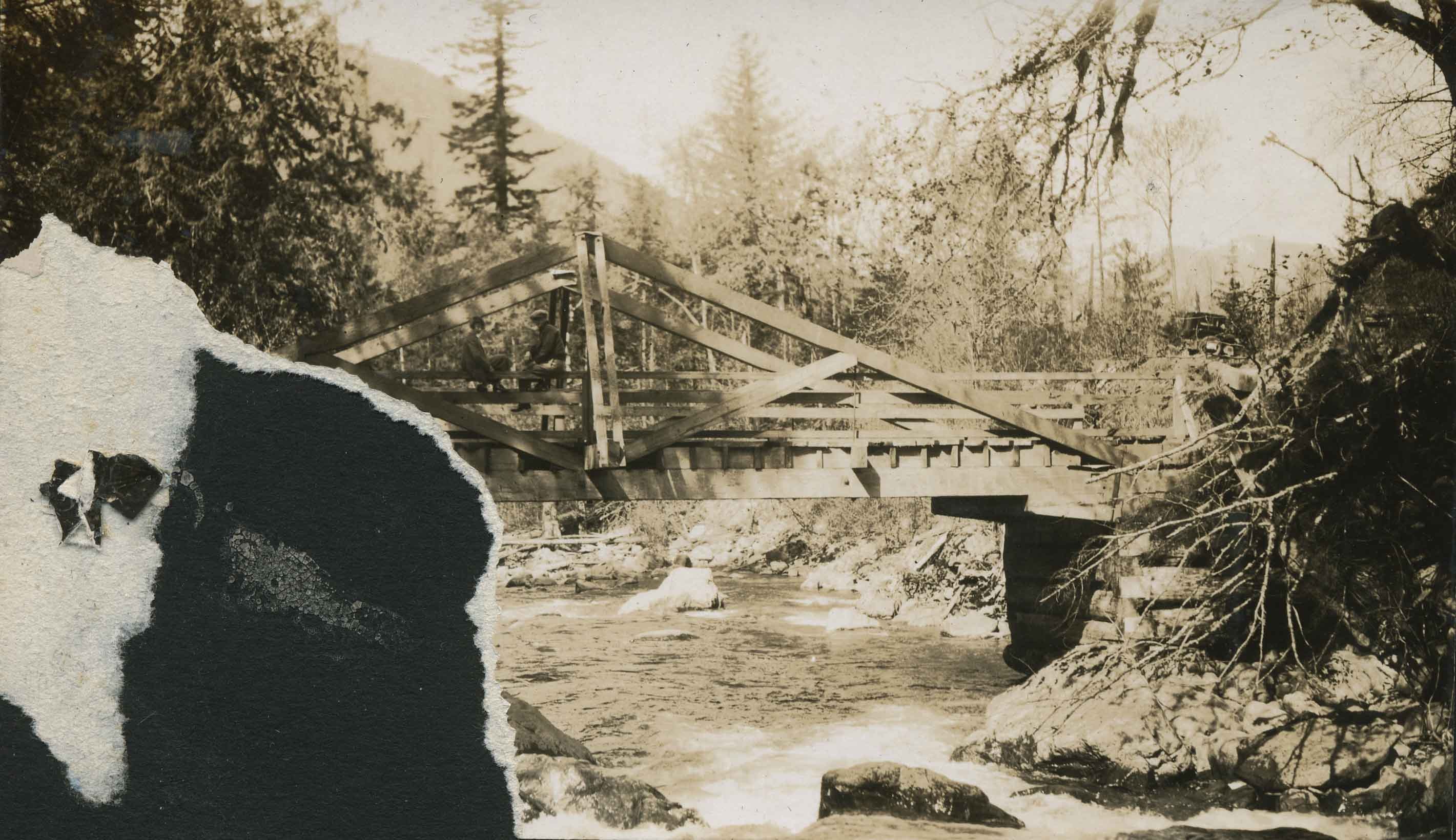
- Scope and Content
- Photograph ofa wooden bridge spanning a river identified as Jones Creek. The lower left corner of the photograph has been torn away. This photograph appears to have been taken by Arthur Peers, who travelled through the Fraser River Valley and worked on the construction of the Trans-Provincial High…
- Repository
- City of Burnaby Archives
- Date
- 1926
- Collection/Fonds
- Burnaby Historical Society fonds
- Subseries
- Peers family subseries
- Physical Description
- 1 photograph : b&w ; 7 x 12 cm on page 17.5 x 26.5 cm
- Description Level
- Item
- Record No.
- 020-096
- Access Restriction
- No restrictions
- Reproduction Restriction
- No known restrictions
- Accession Number
- BHS2007-04
- Scope and Content
- Photograph ofa wooden bridge spanning a river identified as Jones Creek. The lower left corner of the photograph has been torn away. This photograph appears to have been taken by Arthur Peers, who travelled through the Fraser River Valley and worked on the construction of the Trans-Provincial Highway during the later 1920s.
- Media Type
- Photograph
- Photographer
- Peers, Arthur Francis "Mike"
- Notes
- Title based on caption accompanying photograph
Images