Narrow Results By
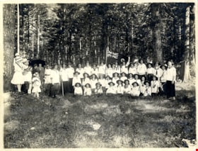
First Burnaby Girl Guide Company in Central Park
https://search.heritageburnaby.ca/link/museumdescription4906
- Repository
- Burnaby Village Museum
- Date
- 1 Jul 1916
- Collection/Fonds
- Burnaby Girl Guides fonds
- Description Level
- Item
- Physical Description
- 1 photograph : sepia ; 16.5 x 21.5 cm
- Scope and Content
- Photograph of the 1st Burnaby Company in Central Park in Burnaby. The girl guides are dressed in white uniforms and are gathered together for a group photograph in a clearing in the woods. One of the girls at the centre of the group is holding a commonwealth flag.
- Repository
- Burnaby Village Museum
- Collection/Fonds
- Burnaby Girl Guides fonds
- Description Level
- Item
- Physical Description
- 1 photograph : sepia ; 16.5 x 21.5 cm
- Scope and Content
- Photograph of the 1st Burnaby Company in Central Park in Burnaby. The girl guides are dressed in white uniforms and are gathered together for a group photograph in a clearing in the woods. One of the girls at the centre of the group is holding a commonwealth flag.
- Names
- Girl Guides of Canada
- Geographic Access
- Central Park
- Accession Code
- BV015.35.264
- Access Restriction
- No restrictions
- Reproduction Restriction
- No known restrictions
- Date
- 1 Jul 1916
- Media Type
- Photograph
- Historic Neighbourhood
- Central Park (Historic Neighbourhood)
- Planning Study Area
- Maywood Area
- Scan Resolution
- 600
- Scan Date
- January 6, 2021
- Scale
- 100
- Notes
- Title based on contents of photograph
- Note in blue ink on verso of photograph reads: "Central Park, Burnaby / July 1, 1916 / 1st Burnaby Company"
- Stamp on verso of photograph reads: "FRANCEL MORKILL / GIRL GUIDE LIBRARY"
- Signature in blue ink on verso of photograph reads: "Amy Leigh"
- Notes in red pencil on verso of photograph read: "8 _ 50%"
- Photograph is a part of scrapbook "Burnaby Girl Guides. -- [1914]-1969, predominant ca. 1920" (BV.015.35.164)
Images

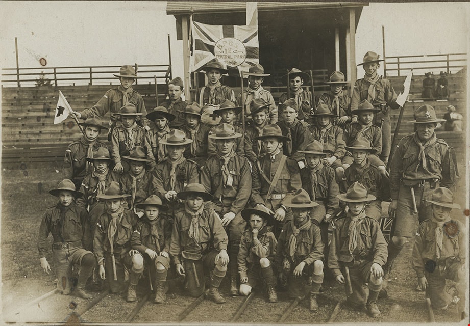
First Central Park B.P. Boy Scouts, 1910
https://search.heritageburnaby.ca/link/museumdescription1055
- Repository
- Burnaby Village Museum
- Date
- 1910
- Collection/Fonds
- Burnaby Village Museum Photograph collection
- Description Level
- Item
- Physical Description
- 1 photograph : b&w ; 12.1 x 17.3 cm mounted on cardboard 22.0 x 27.0 cm
- Scope and Content
- Photograph of the First Central Park troop of Boy Scouts. All but two of them are in uniform, standing at attention. There are 22 boys and 7 men. A man in the centre is holding a flagpole with a Union Jack attached. The Boy Scouts are standing on a cleared field behind which is a building and fores…
- Repository
- Burnaby Village Museum
- Collection/Fonds
- Burnaby Village Museum Photograph collection
- Description Level
- Item
- Physical Description
- 1 photograph : b&w ; 12.1 x 17.3 cm mounted on cardboard 22.0 x 27.0 cm
- Scope and Content
- Photograph of the First Central Park troop of Boy Scouts. All but two of them are in uniform, standing at attention. There are 22 boys and 7 men. A man in the centre is holding a flagpole with a Union Jack attached. The Boy Scouts are standing on a cleared field behind which is a building and forest growth. The location may be Central Park. A caption printed on the bottom front of the frame reads, "First Central Park / B.P. Boy Scou [sic] / 1910." Printed on the lower right front of the frame, "W. Brown, Photo. / New Westminster, B.C."
- Names
- Boy Scouts of Canada
- Geographic Access
- Central Park
- Imperial Street
- Street Address
- 3883 Imperial Street
- Accession Code
- HV973.152.2
- Access Restriction
- No restrictions
- Reproduction Restriction
- No known restrictions
- Date
- 1910
- Media Type
- Photograph
- Historic Neighbourhood
- Central Park (Historic Neighbourhood)
- Planning Study Area
- Maywood Area
- Related Material
- See HV973.152.1 for another photograph of the first central park BP boy scouts.
- Scan Resolution
- 600
- Scan Date
- 2023-06-06
- Photographer
- Brown, William Thomas
- Notes
- Title based on caption of photograph
Images


![First Central Park B.P. Boy Scouts, Central Park, BC, [1910] thumbnail](/media/hpo/_Data/_BVM_Images/1973/1973_0152_0001_001.jpg?width=280)
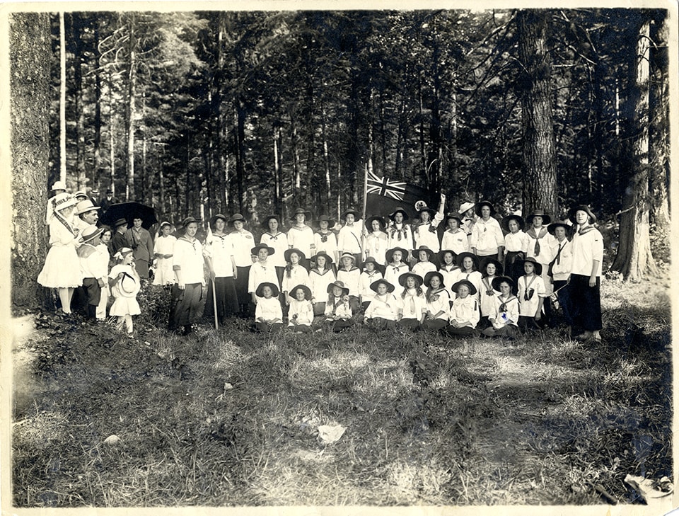
First Central Park B.P. Boy Scouts, Central Park, BC
https://search.heritageburnaby.ca/link/museumdescription1054
- Repository
- Burnaby Village Museum
- Date
- [1910]
- Collection/Fonds
- Burnaby Village Museum Photograph collection
- Description Level
- Item
- Physical Description
- 1 photograph : sepia ; 12.3 x 17.8 cm mounted on cardboard 22.0 x 27.0 cm
- Scope and Content
- Photograph of the First Central Park Troop of Boy Scouts. They are wearing uniforms and posed outside in front of bleachers at Central Park. There are 28 boys ranging in age from about seven to twelve, and four adults. A boy in the back row is holding a Union Jack with a circle in the middle in whi…
- Repository
- Burnaby Village Museum
- Collection/Fonds
- Burnaby Village Museum Photograph collection
- Description Level
- Item
- Physical Description
- 1 photograph : sepia ; 12.3 x 17.8 cm mounted on cardboard 22.0 x 27.0 cm
- Scope and Content
- Photograph of the First Central Park Troop of Boy Scouts. They are wearing uniforms and posed outside in front of bleachers at Central Park. There are 28 boys ranging in age from about seven to twelve, and four adults. A boy in the back row is holding a Union Jack with a circle in the middle in which is written, "B.P.B.S. / 1st / Central Park / Troop." A caption printed on the bottom front of the frame reads, "First Central Park B.P. Boy Scouts, Central Park, B.C." A annotation on the back of the photo reads, "Mr. Robertson."
- Names
- Boy Scouts of Canada
- Geographic Access
- Imperial Street
- Central Park
- Street Address
- 3883 Imperial Street
- Accession Code
- HV973.152.1
- Access Restriction
- No restrictions
- Reproduction Restriction
- No known restrictions
- Date
- [1910]
- Media Type
- Photograph
- Historic Neighbourhood
- Central Park (Historic Neighbourhood)
- Planning Study Area
- Maywood Area
- Related Material
- See HV973.152.2 for another photograph of the first central park BP boy scouts.
- Scan Resolution
- 600
- Scan Date
- 2023-06-06
- Notes
- Title based on caption of photograph
Images
![First Central Park B.P. Boy Scouts, Central Park, BC, [1910] thumbnail](/media/hpo/_Data/_BVM_Images/1973/1973_0152_0001_001.jpg)
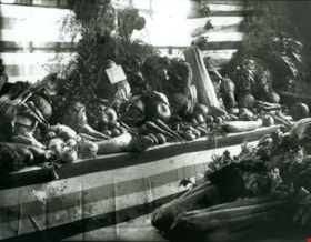
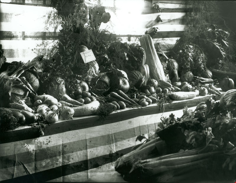
First Prize Vegetable display
https://search.heritageburnaby.ca/link/museumdescription3090
- Repository
- Burnaby Village Museum
- Date
- September 1914
- Collection/Fonds
- Burnaby Village Museum Photograph collection
- Description Level
- Item
- Physical Description
- 1 photograph : b&w glass negative ; 16 x 20.9 cm
- Scope and Content
- Photograph of a vegetable display at the 14th Annual Exhibition of the Central Park Agricultural Association and Farmers' Institute that took place from the 17th to 19th of September, 1914. The display "Surprise Poultry Yards Collection of Vegetables" features the First Prize card on its display.
- Repository
- Burnaby Village Museum
- Collection/Fonds
- Burnaby Village Museum Photograph collection
- Description Level
- Item
- Physical Description
- 1 photograph : b&w glass negative ; 16 x 20.9 cm
- Scope and Content
- Photograph of a vegetable display at the 14th Annual Exhibition of the Central Park Agricultural Association and Farmers' Institute that took place from the 17th to 19th of September, 1914. The display "Surprise Poultry Yards Collection of Vegetables" features the First Prize card on its display.
- Geographic Access
- Central Park
- Imperial Street
- Street Address
- 3883 Imperial Street
- Accession Code
- HV972.11.3
- Access Restriction
- No restrictions
- Reproduction Restriction
- No known restrictions
- Date
- September 1914
- Media Type
- Photograph
- Historic Neighbourhood
- Central Park (Historic Neighbourhood)
- Planning Study Area
- Maywood Area
- Related Material
- For another photograph of a vegetable display at the agricultural exhibition, see HV972.11.17. For a photograph of flower displays at the exhibition, see HV972.11.20
- Scan Resolution
- 300
- Scan Date
- 14/8/2006
- Scale
- 100
- Notes
- Title based on contents of photograph
- 1 b&w contact print accompanying negative
Images
![Men in Central Park, Burnaby, [1910] thumbnail](/media/hpo/_Data/_BVM_Images/1985/1985_0114_0001_001.jpg?width=280)
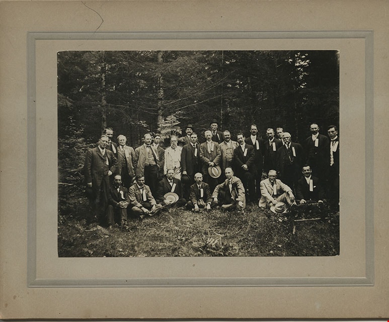
Men in Central Park, Burnaby
https://search.heritageburnaby.ca/link/museumdescription204
- Repository
- Burnaby Village Museum
- Date
- [1910]
- Collection/Fonds
- Burnaby Village Museum Photograph collection
- Description Level
- Item
- Physical Description
- 1 photograph : b&w ; 11.4 x 15.7 cm mounted on cardboard 17.8 x 22.7 cm
- Scope and Content
- Photograph of a group of twenty-five middle aged men dressed in suits, vests and hats, in Central Park in Burnaby. They all have ribbons pinned to their lapels. The information written on the ribbons is not visible. A note on file at the Burnaby Village Museum indicates that this group may have bee…
- Repository
- Burnaby Village Museum
- Collection/Fonds
- Burnaby Village Museum Photograph collection
- Description Level
- Item
- Physical Description
- 1 photograph : b&w ; 11.4 x 15.7 cm mounted on cardboard 17.8 x 22.7 cm
- Scope and Content
- Photograph of a group of twenty-five middle aged men dressed in suits, vests and hats, in Central Park in Burnaby. They all have ribbons pinned to their lapels. The information written on the ribbons is not visible. A note on file at the Burnaby Village Museum indicates that this group may have been a fraternal lodge group.
- Subjects
- Geographic Features - Parks
- Geographic Access
- Central Park
- Imperial Street
- Street Address
- 3883 Imperial Street
- Accession Code
- BV985.114.1
- Access Restriction
- No restrictions
- Reproduction Restriction
- No known restrictions
- Date
- [1910]
- Media Type
- Photograph
- Historic Neighbourhood
- Central Park (Historic Neighbourhood)
- Planning Study Area
- Maywood Area
- Scan Resolution
- 600
- Scan Date
- 2024-01-23
- Notes
- Title based on contents of photograph
Images
![Men in Central Park, Burnaby, [1910] thumbnail](/media/hpo/_Data/_BVM_Images/1985/1985_0114_0001_001.jpg)
![Prize Winning Flower displays, [September 1914] thumbnail](/media/hpo/_Data/_BVM_Images/1971/197200110020.jpg?width=280)
Prize Winning Flower displays
https://search.heritageburnaby.ca/link/museumdescription3106
- Repository
- Burnaby Village Museum
- Date
- [September 1914]
- Collection/Fonds
- Burnaby Village Museum Photograph collection
- Description Level
- Item
- Physical Description
- 1 photograph : b&w glass negative ; 16 x 20.8 cm
- Scope and Content
- Photograph of various flower displays with signs that indicate the prize they earned at the 14th Annual Central Park Agricultural Association and Farmers's Institute Exhibition. There are at least three First Prize flower displays in view and one Special Prize. This is most likely at the 14th An…
- Repository
- Burnaby Village Museum
- Collection/Fonds
- Burnaby Village Museum Photograph collection
- Description Level
- Item
- Physical Description
- 1 photograph : b&w glass negative ; 16 x 20.8 cm
- Scope and Content
- Photograph of various flower displays with signs that indicate the prize they earned at the 14th Annual Central Park Agricultural Association and Farmers's Institute Exhibition. There are at least three First Prize flower displays in view and one Special Prize. This is most likely at the 14th Annual Exhibition of the Central Park Agricultural Association and Farmers' Institute that took place from the 17th to 19th of September, 1914. An earlier catalogue record from 1988 notes that the pictures hanging from the backwall are probably children's school work from Kingsway West School. It also adds the agricultural fair was held between 1902 to 1921 in the Central Park Agricultural Hall built in 1902 in Central Park on Kingsway and the B.C.E.R. tracks.
- Geographic Access
- Central Park
- Imperial Street
- Street Address
- 3883 Imperial Street
- Accession Code
- HV972.11.20
- Access Restriction
- No restrictions
- Reproduction Restriction
- No known restrictions
- Date
- [September 1914]
- Media Type
- Photograph
- Historic Neighbourhood
- Central Park (Historic Neighbourhood)
- Planning Study Area
- Maywood Area
- Related Material
- For photographs of vegetable displays at the agricultural exhibition, see HV972.11.3 and HV972.11.17.
- Scan Resolution
- 300
- Scan Date
- 14/8/2006
- Scale
- 100
- Notes
- Title based on contents of photograph
- 1 b&w contact print accompanying negative
Images
![Prize Winning Flower displays, [September 1914] thumbnail](/media/hpo/_Data/_BVM_Images/1971/197200110020.jpg)

Survey and Subdivision plans in New Westminster District Group 1 – Burnaby
https://search.heritageburnaby.ca/link/museumdescription6971
- Repository
- Burnaby Village Museum
- Date
- 1904-1908
- Collection/Fonds
- Burnaby Village Museum Map collection
- Description Level
- File
- Physical Description
- 7 plans : blueprint ink on paper mounted on 2 sides of cardboard 76 cm x 101.5 cm
- Scope and Content
- Item consists of a large board of four New Westminster District Gp 1 -subdivision plans mounted on one side and three New Westminster District Gp 1 - subdivision plans mounted on the other side. Side A: 1. Blueprint "Plan / of Subdivision of / Lot 28A / in Subdivision of / Lot 97, Group 1 / Ne…
- Repository
- Burnaby Village Museum
- Collection/Fonds
- Burnaby Village Museum Map collection
- Description Level
- File
- Physical Description
- 7 plans : blueprint ink on paper mounted on 2 sides of cardboard 76 cm x 101.5 cm
- Material Details
- Scales [between1:120 and 1:3960]
- Index number on edge of board reads: "3"
- Scope and Content
- Item consists of a large board of four New Westminster District Gp 1 -subdivision plans mounted on one side and three New Westminster District Gp 1 - subdivision plans mounted on the other side. Side A: 1. Blueprint "Plan / of Subdivision of / Lot 28A / in Subdivision of / Lot 97, Group 1 / New Westminster District". The B.C.E.R. is identified running through the subdivision of XXVIIIA (Lot 28A). Plan is dated "Sept. 21st, 08" (Geographic location: Burnaby) 2. Blueprint "Measurements / of Discharge / in Ditches / Lots 155A, G.One" / "Scale, Twentieths. / 17/12/04" (Geographic location: Burnaby) 3. Blueprint "Plan / of Subdivision / of a portion of / Lot 95 / Group One / New Westminster District" B.C. Electric Railway runs through the top of the plan. The plan is dated May 23, 1906. (Geographic location: Burnaby) 4. Blueprint " Profile / on Water Surface / in / Holland Road Ditch / Woollard's Ditch / Dec. 3rd 1904 / Scales Hor. 200'=1" / Vert. 10'=1"" (Geographic location: Burnaby) Side B: 1. Blueprint " "Sunnyside Park" / plan of Subdivision / of / the East Half / of / Lot 39, GR.One, / New Westminster District / Scale 100'=1" (Geographic location: Burnaby) 2. Blueprint " "Sunnyside Park"/ plan of Subdivi..n / of / Lot 39, Gr.1. / New Westminster District" Index in upper left corner of plan shows location of Lot 39 in relation to Central Park and surrounding Lots. (Geographic location: Burnaby) 3. Blueprint "Plan / of Subdivision / of / Lot 163 and 165 / Group One / New Westminster District / Scale 5 chs=1 in." Streets within subdivision plan are identified as; North Arm Road, Ingram Street, Blair Street, Kennedy Street, Murray Street, Wiggins Road, Byrne Road, South Road along with North Arm Fraser River and B.C. Electric Railway. (Geographic location: Burnaby)
- Geographic Access
- Central Park
- Accession Code
- HV977.93.3
- Access Restriction
- No restrictions
- Reproduction Restriction
- No known restrictions
- Date
- 1904-1908
- Media Type
- Cartographic Material
- Historic Neighbourhood
- Central Park (Historic Neighbourhood)
- Scan Resolution
- 300
- Scale
- 72
- Notes
- Title based on contents of file
- Scale is measured in chains and feet. (One chain equals 792 inches)
- The term "Lot" can also refer to a "District Lot”
Images


![Survey and Subdivision plans in New Westminster District Group 1 – Burnaby, [1905-1917] thumbnail](/media/hpo/_Data/_BVM_Cartographic_Material/1977/1977_0093_0022a_001.jpg?width=280)
Survey and Subdivision plans in New Westminster District Group 1 – Burnaby
https://search.heritageburnaby.ca/link/museumdescription6991
- Repository
- Burnaby Village Museum
- Date
- [1905-1917]
- Collection/Fonds
- Burnaby Village Museum Map collection
- Description Level
- File
- Physical Description
- 12 plans : 6 black ink on paper + 2 black & col. ink on paper + 4 graphite on paper
- Scope and Content
- Item consists of a large board of six New Westminster District subdivision plans mounted on one side and six New Westminster District subdivision plans mounted on the other side. Side A: 1. Plan drawn in graphite with markings in black ink "Surveyed for Mr. W. Wilson / Paterson Stat. B.C.E.R." . …
- Repository
- Burnaby Village Museum
- Collection/Fonds
- Burnaby Village Museum Map collection
- Description Level
- File
- Physical Description
- 12 plans : 6 black ink on paper + 2 black & col. ink on paper + 4 graphite on paper
- Material Details
- Scales [between 1:360 and 1:3168]
- Index number on edge of board reads: "22"
- Scope and Content
- Item consists of a large board of six New Westminster District subdivision plans mounted on one side and six New Westminster District subdivision plans mounted on the other side. Side A: 1. Plan drawn in graphite with markings in black ink "Surveyed for Mr. W. Wilson / Paterson Stat. B.C.E.R." . Plan includes subdivision of lots situated between B.C.E. Railway and Vancouver Road (Kingsway). (Geographic location: Burnaby) 2. Subdivision plan (no title) drawn in black ink with annotations in graphite. Plan covers District Lots 2, 4 and 6, west of North Road. Plan is stamped: "Albert J. Hill, Civil Engineer / and / Provincial Land Surveyor, / New Westminster, / B.C. (Geographic location: Burnaby) 3. Plan of "Portion of Municipality" with intials "RB" [sic] (handwritten in blue crayon). Plan covers the area north east of the City of New Westminster including District Lots 11, 13, 14, 12, 1 and 2. Plan is stamped: "Albert J. Hill, Civil Engineer / and / Provincial Land Surveyor, / New Westminster, / B.C. (Geographic location: Burnaby) 4."Plan / of Subdivision of / N.W.1/4 Lot 175 / Group 1 New West. Dist. / B.C. / Scale 4 chs = 1 in. " Plan is stamped: "Albert J. Hill, Civil Engineer / and / Provincial Land Surveyor, / New Westminster, / B.C. and initialed : "RB" [sic] (in blue pencil crayon) (Geographic location: Burnaby) 5. "Subdivision / of a Portion of / Lot 15 Group 1 / New Westminster Dist. / Scale 4 chs = 1 in". Plan provides numbered sudivisions - Lots 1 to 15 of District Lot 15 in red ink. (Geographic location: Burnaby) 6. Plan of "Central Park & / Vicinity" Plan includes subdivisions of District Lot 153 east of Central Park District Lot 151 and subdivision of District Lot 36 and 49 west of Boundary Road (Vancouver). Plan is stamped: "Albert J. Hill, Civil Engineer / and / Provincial Land Surveyor, / New Westminster, / B.C. and initialed : "RB" [sic] (in blue pencil crayon). (Geographic location: Burnaby) Side B: 1. Subdivision plan (no title) drawn in black ink. Plan identifies lots between Vancouver Road (Yale Road is crossed out and replaced with Vancouver Road) and B.C.E. Railway. "Scale 2 chs = 1 in" (Geographic location: Burnaby) 2. Plan of "Subdivision Lot 1 / Lot 69 Gr. 1 / Scale 30' = 1 " " Plan identifies Boundary Road, Still Creek and a Road Allowance between District Lot 118 and District Lot 69. Plan was "Surveyed for Burnaby Mun. Council / March 11th 1908 / G.K.B." (Geographic location: Burnaby) 3. Plan drawn in black ink (no title) showing a subdivision in Lot 25 with names "Newcomb", "Debeck" and "Armstrong" along with roads identified as Third Street, Cumberland Street, Armstrong Street and Cariboo [sic] Street and including Lots 27, 11 and 13.Plan is stamped: "Albert J. Hill, Civil Engineer / and / Provincial Land Surveyor, / New Westminster, / B.C. and initialed : "RB" [sic] (in blue pencil crayon). (Geographic location: Burnaby) 4. Handrawn subdivision plan in graphite titled: "Lot 13, Gr.1" with intials "RB" [sic] (handwritten in blue crayon). Plan is bordered by Armstrong Street (Lot 11, G.1), Cumberland St. (Lot 25, G.1) and Tenth Avenue (City Boundary). The plan is singed by "Albert J. Hill / P.L.S." and one of the subdivided lots is identified with the name: "W. Karrymann". (Geographic location: Burnaby) 5. Handrawn sketch in graphite titled: "Lot 88, Gr.1" with intials "RB" [sic] (handwritten in blue crayon). Plan appears to be a draft of a subdivision plan of a portion of District Lot 88 along Cumberland Road. The plan is signed: "16/7/17 _W.F. Draper [sic] / B.C.L.S." (Geographic location: Burnaby) 6. "Plan / of Subdivision / of Blocks 61, 62 and 2 / Lot 30 / Group 1 / N.W. Dist. / Scale 1ch = 1 in". Plan is intialed by: "PB" with a note: "Also see board 2 / for duplicate" (handwritten in blue crayon). (Geographic location: Burnaby)
- Creator
- Hill, Albert James
- Geographic Access
- Boundary Road
- Kingsway
- Cumberland Street
- Accession Code
- HV977.93.22
- Access Restriction
- No restrictions
- Reproduction Restriction
- No known restrictions
- Date
- [1905-1917]
- Media Type
- Cartographic Material
- Historic Neighbourhood
- Central Park (Historic Neighbourhood)
- Scan Resolution
- 300
- Scale
- 100
- Notes
- Title based on contents of file
- Scale is measured in chains and feet. (One chain equals 792 inches)
- The term "Lot" can also refer to a "District Lot”
- Some plans are stamped: "Albert J. Hill, Civil Engineer / and / Provincial Land Surveyor, / New Westminster, / B.C." and intialed: "RB" [sic]
Images
![Survey and Subdivision plans in New Westminster District Group 1 – Burnaby, [1905-1917] thumbnail](/media/hpo/_Data/_BVM_Cartographic_Material/1977/1977_0093_0022a_001.jpg)

![Vegetable display, [September 1914] thumbnail](/media/hpo/_Data/_BVM_Images/1971/197200110017.jpg?width=280)
Vegetable display
https://search.heritageburnaby.ca/link/museumdescription3103
- Repository
- Burnaby Village Museum
- Date
- [September 1914]
- Collection/Fonds
- Burnaby Village Museum Photograph collection
- Description Level
- Item
- Physical Description
- 1 photograph : b&w glass negative ; 16.4 x 21.3 cm
- Scope and Content
- Photograph of a vegetable display with a sign that reads, "GROWN FROM/ RENNIE'S/ SEEDS" and another sign indicating that the display is "Not for Competition/ Burnaby Production/ by/ Wm. Baily [illegible]". This is most likely at the 14th Annual Exhibition of the Central Park Agricultural Associati…
- Repository
- Burnaby Village Museum
- Collection/Fonds
- Burnaby Village Museum Photograph collection
- Description Level
- Item
- Physical Description
- 1 photograph : b&w glass negative ; 16.4 x 21.3 cm
- Scope and Content
- Photograph of a vegetable display with a sign that reads, "GROWN FROM/ RENNIE'S/ SEEDS" and another sign indicating that the display is "Not for Competition/ Burnaby Production/ by/ Wm. Baily [illegible]". This is most likely at the 14th Annual Exhibition of the Central Park Agricultural Association and Farmers' Institute that took place from 17th to 19th of September 1914. An earlier catalogue record from 1988 notes that the agricultural fair was held between 1902 to 1921 in the Central Park Agricultural Hall built in 1902 in Central Park on Kingsway and the B.C.E.R. tracks.
- Geographic Access
- Central Park
- Imperial Street
- Street Address
- 3883 Imperial Street
- Accession Code
- HV972.11.17
- Access Restriction
- No restrictions
- Reproduction Restriction
- No known restrictions
- Date
- [September 1914]
- Media Type
- Photograph
- Historic Neighbourhood
- Central Park (Historic Neighbourhood)
- Planning Study Area
- Maywood Area
- Related Material
- For another photograph of a vegetable display at the agricultural exhibition, see HV972.11.3. For a photograph of flower displays at the exhibition, see HV972.11.20
- Scan Resolution
- 300
- Scan Date
- 14/8/2006
- Scale
- 100
- Notes
- Title based on contents of photograph
- 1 b&w contact print accompanying copy negative
Images
![Vegetable display, [September 1914] thumbnail](/media/hpo/_Data/_BVM_Images/1971/197200110017.jpg)